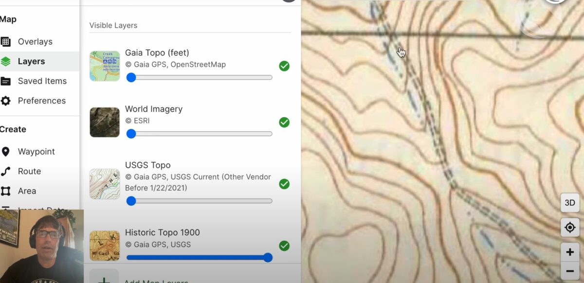
There’s nothing more serendipitous than stumbling across an old road bed while bushwhacking. But you don’t just have to rely on blind luck. With a combination of modern satellite imagery and historical USGA topo maps, you can incorporate such features into your route planning.
In the following video, Ryan Jordan demonstrates:
- how to find and use historical USGS topo maps in Gaia GPS
- how to identify person-made features in satellite imagery
- how to use Gaia GPS layers to confirm your suspicions about possible routes of least resistance
Editor’s Note: This video was shot before we released our First Look review of the Tarptent Dipole Li 1 and 2, so that’s why you’ll notice it blurred out in the video. If you missed that review, check it out here!
And don’t miss our How to Use Gaia GPS Masterclass for more tips like this!
Learn More
Browse our curated recommendations in the Backpacking Light Gear Shop – a product research & discovery tool where you can find Member gear reviews, Gear Swap (used gear) listings, and more info about specific products recommended by our staff and members.
Gear Shop » Software
Related Content
- enroll in our How to Use Gaia GPS Masterclass (free for unlimited members)
- watch the related video: How to Use Gaia GPS Slope Angle Overlays & Satellite Imagery to Plan Off-trail Routes
- listen to our Digital Route Planning podcast episode
- read our How to Plan a Backpacking Trip Trailhead
DISCLOSURE (Updated April 9, 2024)
- Backpacking Light does not accept compensation or donated/discounted products in exchange for product mentions or placements in editorial coverage. Some (but not all) of the links in this review may be affiliate links. If you click on one of these links and visit one of our affiliate partners (usually a retailer site), and subsequently place an order with that retailer, we receive a commission on your entire order, which varies between 3% and 15% of the purchase price. Affiliate commissions represent less than 15% of Backpacking Light's gross revenue. More than 70% of our revenue comes from Membership Fees. So if you'd really like to support our work, don't buy gear you don't need - support our consumer advocacy work and become a Member instead. Learn more about affiliate commissions, influencer marketing, and our consumer advocacy work by reading our article Stop wasting money on gear.

Discussion
Become a member to post in the forums.
Companion forum thread to: How to use Gaia GPS to Find Hidden Backcountry Routes
Learn Ryan Jordan’s process for discovering hidden backcountry routes by integrating current base maps, satellite imagery layers, and historical USGS maps.
This is a good tip. I’ve seen many trails decommissioned in my own lifetime, and I continue to use them. This led me to understand that historical USGS maps can be a good resource for abandoned routes and I’ve been doing it routinely for many years. As you probably know, you can download them from the USGS site directly with no fee.
Nice job Ryan. Love the tip. Also love the length of this video. I was drinking my coffee and had a few minutes so dove in. Fewer chances for the longer stuff. Thank you!
Become a member to post in the forums.