In the northwest corner of the Kodiak Archipelago is a 50,000-acre annex of the Kodiak National Wildlife Refuge on Afognak Island. It is characterized by old-growth, moss-enrobed Sitka spruce forest, steep mountains that stood as nunataks during the most recent glacial maximum, and a myriad of large and small mountain lakes. It is home to one of the largest Roosevelt elk herds on Afognak Island, the ‘Waterfall’ herd. There are only a small number of salmon streams in the area due to the steep gradients and waterfalls limiting spawning habitat. The coastline is convoluted and rugged, facing the Shelikof Strait across which “Ring of Fire” volcanoes dominate the Katmai skyline. This is one of the most remote and least visited parts of Alaska. And also, one of the most beautiful.
Much of the Kodiak Archipelago is a nearly impenetrable vegetative wall of salmonberry and alder. The alpine is the only pleasant hiking option in many areas. But in the KNWR section of Afognak Island, a lush and pleasantly inviting understory of blueberry, skunk cabbage, ferns, and dwarf salmonberry make cross country travel possible. In some pockets, a thick jungle of devils club awaits, but when you can find a well-trodden elk trail going in your intended direction of travel, even these areas can be easily negotiated. [Note: for those not familiar with devils club, a common coastal Alaskan witticism is that if you find yourself trapped between a patch of devils club and a bear, always run towards the bear.]
One of the best kept secrets for budget-minded adventurers in Alaska is taking the “mail plane.” These are relatively inexpensive seat fares that offer access to many small communities throughout Alaska, and one of my favorite jumping off points for travel in the north end of the Kodiak Archipelago is to fly to Port William on the south side of Shuyak Island, a twice-weekly, 45-minute, $140 hop in a float plane. Nicely situated in Shuyak Strait between Shuyak Island (a state park) and Afognak Island, Port William is a now-defunct herring saltery and salmon cannery from which you can travel in literally any direction depending on ‘which way the wind is blowing.’
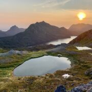
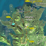
I began my loop down through the length of the KNWR on Afognak Island by paddling across Shuyak Strait from Port William and into Redfox Bay. From there I hiked across a forested peninsula to Bluefox Bay, a lovely and protected, island-dotted, mountain-ringed embayment at the entrance to Shuyak Strait. A short hike following the outlet of Red Peak Lake brought me to the alpine south of Red Peak where I camped the first night. Stunning views of the mountains and lakes of NW Afognak set the foreground for a sweeping vista that stretches across the Shelikof Strait to the towering, snowy shield volcanoes of the Alaska Peninsula. Forest fires thousands of miles away in Siberia offered a slight haze that made for a brooding, sepia sunset.
The next morning I hiked over a low mountain from which I could observe almost my entire intended route, including a section where I had never traveled before; a ridgeline running from Foul Bay to the southern border of the KNWR. I scanned for wildlife as I moved but the Waterfall elk herd rarely comes this far north in numbers. The area offers good denning options for brown bears and the lack of major salmon runs makes the forest and alpine a desirable respite for sows with cubs to forage with less danger of coming across a boar, which are known to kill cubs. It is far less common to see Kodiak bears on Afognak Island compared to Kodiak due to the dense forest cover, and indeed the only bears I encountered were sows with cubs. Alaska is thick with nesting birds in the summers, and the forest air is a lovely cacophony of their calls announcing territories or seeking mates.
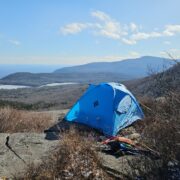
I was forced to drop below the alpine and into the forest to negotiate a low break in the ridge that led me south. Here I encountered the only real salmonberry and alder patch of the whole trip, and even that only caused me a few hundred yards of brush swimming; a veritable miracle of easy passage for anyone familiar with typical coastal Alaskan travel. Back in the alpine I continued south to a small mountain tarn still half frozen in mid-July and ringed with sun cupped snow slopes and ribbons of flower meadow. That evening as I prepared to turn in, a sow with a single cub traversed the cirque on the opposite side of the tarn and they grazed their way across the slope as the light faded. The cub had the typical “natal collar” of light ruff around its neck and down its chest, but the mother conspicuously also wore a silvery collar and bright frosted ear tips- a very unusual patterning for a Kodiak bear.
The next morning I swung around the southernmost extent of the mountain horseshoe I was following, and this is where I began to see bachelor groups of bull Roosevelt elk from the Waterfall herd, and eventually also about 70 cows and calves from the main body of the herd. They were grazing and resting contentedly in the warmth of midday at the transition from lower elevation brush to the alpine. Now traveling north towards Foul Bay and Hidden Lake, I followed well-defined elk trails through jack spruce and flower meadows. The slope off the last peak in the ridge down to Hidden Lake Creek could have been a nightmare of head-high and thickly intertwined devils club, but I was able to follow a hoof-chopped, muddy elk trail all the way to the river below. A short paddle up the river brought me to a low falls marking the outlet of Hidden Lake. After paddling the length of Hidden Lake, I hiked through lush (and markedly more inviting forest than I had experienced a few hours earlier) to reach tidewater at Devil Inlet.
The narrow entrance to the inlet restricts the volume of seawater flooding and ebbing into the basin. The tidal range inside the inlet is only 1-2 feet while outside in the Shelikof the tidal swing can be over 15 feet. This sets up a class 2 rapid at the narrows that reverses its flow 4 times per day, and only offers a few minutes of calm, slack water at a mid-stage of the outside tide. The rapid is easily avoided using wide game trails on either side of the narrows in the forest. At the entrance to Devil Inlet is a lovely granite cape capped by a small flower meadow that offers a perfect campsite with views into the inlet, out into Devil Bay, and again across the Shelikof to the mainland. Pocket beaches on either side of the tiny cape offer good landing and launch options no matter the wind direction, though the Shelikof Strait is no place for a small boat in anything other than the most benign conditions.
On the 4th day I spent most of the day in the packraft, working my way up through Devil Bay, past the entrance to Bluefox Bay, and into Shuyak Strait to Port Lawrence, a small bight just west of Port William, which is a fine spot to spend the last night before the morning mail plane. The final morning just involved paddling around a small headland and waiting at the old cannery for the mail plane back to Kodiak to arrive.


Home › Forums › Hiking and Packrafting the Kodiak National Wildlife Refuge on Afognak Island, Alaska