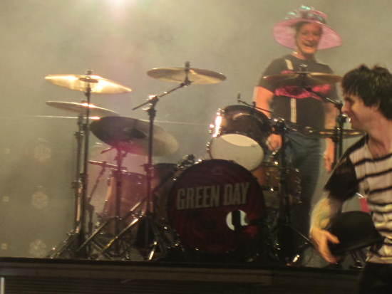
LOL!!!!! How about Green Day?
Topic
Become a member to post in the forums.
LOL!!!!! How about Green Day?
I exported the map that I posted earlier and then imported it into Garmin Basecamp. The points plot, and everything looks good at least with the high level map that comes with Basecamp.
So, you should be able to export and load to your GPS if your GPS is compatible with GPX format, possibly KML also although I haven’t tried that.
The universe seems to be conspiring to derail this trip for me but looks like Houston has cleared me for launch.
Here are the driving instructions per MapQuest; do these look correct?
20. Merge onto I-680 S via EXIT 40 toward Benicia/San Jose.
21. Merge onto US-101 S toward Los Angeles 25.2 mi
22. Take the Masten Ave exit. 0.4 mi
23. Turn left onto Masten Ave. If you reach US-101 S you've gone about 0.2 miles too far 1.0 mi
24. Turn right onto Center Ave. 0.4 mi
25. Take the 2nd left onto Rucker Ave. Rucker Ave is 0.3 miles past Villa Real Ct
If you reach Omar Ave you've gone about 0.5 miles too far 0.8 mi
26. Turn right onto New Ave. 1.6 mi
27. Turn left onto Roop Rd. Roop Rd is 0.1 miles past Justin Morgan Dr
If you reach Dryden Ave you've gone about 0.3 miles too far 1.9 mi
28. Turn left to stay on Roop Rd. 1.3 mi
29. Roop Rd becomes Gilroy Hot Springs Rd. 3.4 mi
30. [4200-4699] GILROY HOT SPRINGS RD.
Your destination is 0.7 miles past Canada Rd
If you reach the end of Gilroy Hot Springs Rd you've gone about 2.7 miles too far
That doesn’t sound right. You should be on E Dunne Ave. let me look it up.
Ian,
I think that’s taking you to another entrance, not the entrance you want. Try these Google directions. They’re arbitrarily from the Oakland airport, but you can customize your start point as suits you.
EDIT: if the link isn’t working, try cutting and pasting this: http://goo.gl/maps/7xpqc
Thanks Jim. I see a discrepancy with the address but I know the address for some of our local parks are off site so I wasn't sure.
Edit: We were typing at the same time. I just looked at the link for Google and will use them instead. Thanks for your help.
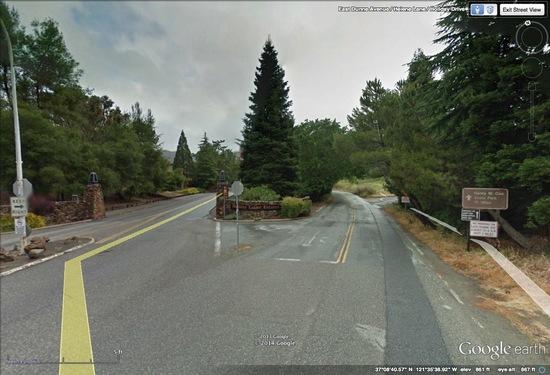
Basically, you just get off the 101 onto E Dunne Ave and keep going until you get to Henry Coe State Park. Click to enlarge
I had issues too, until I went with a different source and came up with the E Dunne Rd. Fewer points to check in my 5 hour drive. Still need to get a newer CA map in case I end up in downtown Fresno.
Feeling better, hope to still go, family situ is looking much better. Been loaded since Saturday, just need a few dinners and some more breakfast food.
Duane
Been loaded since Saturday…
Well, I do hope you’ll sober up before you drive down, Duane. You can always get loaded again once you arrive…
Ian,
Just choose "Morgan Hill, CA" as your destination instead of Henry Coe State Park. There are 3 exits for Morgan Hill; Dunne St is the middle one.
All:
What are folks bringing for insulation, standing around camp? I'm unable to get my head wrapped around the idea that it is nearly summer conditions at Henry Coe. Also, it looks like a rain shell isn't really necessary this weekend. Thoughts?
HJ, I'll be hitting it hard Friday and Saturday, I'm bringing three SN Celebration Ales, stand back. :) Ken is hauling my chair. Who has the ice concession?
I can't quite wrap around either to go prepped for a summer like trip. I have some down gear, but a summer quilt (new).
Duane
I’m thinking it’ll still be plenty cold at night. Probably not freezing conditions, but cold enough. I’m for sure bringing a down sweater and a shell. Not sure about the down pants; probably won’t need them. I’m bringing my Summerlite bag (32F/0C rating) and a 3/4 length NeoAir (to be used with my backpack under my feet. I’m going to use a light weight bivy under my tarp since it might be windy according to the forecast.
> I have some down gear, but a summer quilt (new).
Bring your quilt and your down gear. If it gets too cold for the quilt, wear the down gear under the quilt, yes?
Click to enlarge.
Could it really be that warm at night? They’re predicting temps down in the 30’s in nearby Morgan Hill. I think I’m going to plan for temps in the 40’s at night.
Thanks for steering Ian the right way.
It is nearly 8PM It is still 57 degrees out. 46 at 6AM Pretty mild. But standing around, well I am bringing a jacket certainly.
"Thanks for steering Ian the right way.'
Never an easy task I must admit.
"Never an easy task I must admit."
I see it was a group effort. Take a look at this photo of the confusing intersection. The rest of your drive is simple. This might be your only hiccup.
Stay right. It gets real windy and narrow. 10 miles more and you are there. Those coming by bicycle, you're animals.
I'm thinking if everyone vows not to bring a rain shell, and if in fact nobody brings a rain shell to the GGG, our collective odds of getting some rain in this state might actually improve. This would be directly proportional to the increased individual odd that each of will get rain sheerly because of murphy's law with respect to forgotten rain gear. Anyway, worth a shot.
On a more serious note, are we definitive on alcohol stoves? I'm thinking a canister stove will be best for me, but wanted to know if, for example, the burn-off is on the even list or off. I read most of these 15 pages but not all so … sorry if I missed it.
Use your fire sense. No wood fires so burn off is off. Canisters would be easy.
The automated weather station referenced above is one ridge over, at the same elevation, 0.75 miles as the crow flies, from the GGG camp sites: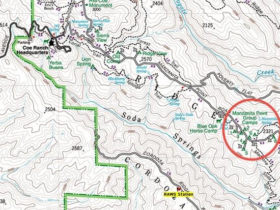
For the past week, lows have been 44° F to 52° F, highs 70° F to 74° F, though the NWS forecast is mid-60s for this weekend.
You can check the weather station and forecasts at the last minute to help decide how much warm clothing to bring.
Standing around shooting the breeze at 44° F first thing in the morning can get chilly.
— Rex
Last spring Coe Park installed two large water tanks very close to the GGG camp sites. One tank is about 0.7 mile before you get to the camp sites; the other is right in the middle of the group camp sites.
Quoting from the Pine Ridge Association newsletter late Spring 2013:
New! Two Water Tanks for Visitors
Eric Griggs has just installed two 500-gallon water tanks, one at the junction of Manzanita Point Road and Poverty Flat Road and one at the junction of the Madrone Soda Springs Trail, the China Hole Trail, and the Manzanita Point Road. The PRA board agreed to fund the purchase of the tanks last year and Eric has just installed them on wooden platforms set on concrete supports at these two busy trail intersections. Be sure to tell people about them, and mention that the water is potable; Eric is working out the wrinkles to have the signage added but until that’s in place visitors need to know. Having that water available will save park staff lots of trips to help dehydrated visitors, especially with the weather warming.
— Rex
I only have two sleeping bag options at the moment. One is a large, fairly heavy synthetic 0*F mummy bag. The other is a synthetic 40* quilt. Based on these weather forecasts I'm thinking I might bring the quilt instead. A couple hand warmers for good measure and it should be a lot less bulky and heavy than the 0* bag.
This will be my first backpacking experience not requiring a bear vault. Hahaha. I'm still trying to wrap my head around what to do with all the extra space in my pack. ;-)
Heck, I've been snow/snowless camping already this season with most nights in the teens and one sub zero night close to Carson Pass. I'll just sleep on a gc in my shorts since Henry Coe will be so warm. :)
Duane
That’s 35 people per pit; standing in a circle shoulder-to-shoulder at 18 inches (hah!), means everyone is about 8.4 feet from the fire pit. Not much warmth.
Or, we could huddle like penguins: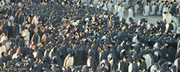
Coordinated Movements Prevent Jamming in an Emperor Penguin Huddle
— Rex
Become a member to post in the forums.
 Carbon Fiber Power Bank20,000 mAh power bank with a lightweight carbon-fiber shell.
 Loading...