Perhaps a "repeat post", but Search didn't find it …
Topic
Become a member to post in the forums.
Perhaps a "repeat post", but Search didn't find it …
We are in full Spring mode here. I do not think we will get anymore cold weather. No more snow. and not much rain in the future. Going to continue being really, really dry. Better dust off the canister stoves.
It's storming today supposedly – saw the clouds building up there yesterday. But it's not likely to make a huge difference, as the melting already started with the ridiculous warm weather. Just enough to make people who think they can go out for a week without snow in March frustrated.
I'm wondering how long before the mass exodus begins, and the trees all start to fall.
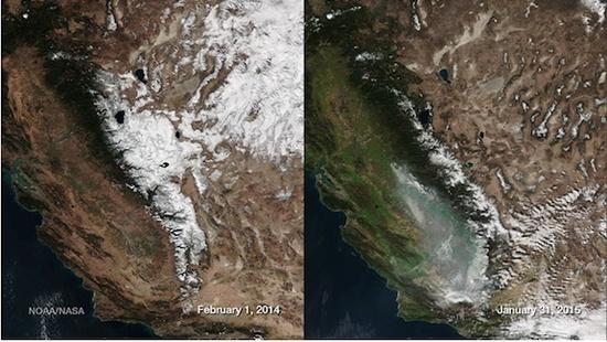
I just called a bunch of wilderness rangers in various USFS offices around the Sierra. It's really bad. Yosemite is reporting no snow below about 8500 feet…the overall snowpack is at 5% of normal.
If you've been reading the news, you know that the snowpack in some parts of the Sierra is 5% of normal. That's a disaster.
It's so dry that we're seriously considering taking a few backpacking trips this spring that head up into the Sierra high country. Normally, we're not excited about sleeping on snow, spending ten hours of darkness in our tent, or slipping and sliding over ice and mush for much of the day.
But this year, those seems like high class problems. There is no snow in the Sierra, particularly if you head further south. We called four different ranger stations in the last twenty-four hours to discuss the conditions on the trails in their area. Here's what we learned:
Beasore Road out of Bass Lake in the Sierra National Forest is open and clear all way to Globe Rock. The side roads to the various trailheads in that region may also be clear, but nobody from the USFS has bothered to drive them yet. This road generally doesn't open up until late May or June. It's March. Snow levels are at about 8500 feet or so. They suggested that hikers might be more worried about mud than snow.
On the East side, many roads and trailheads are open in the Hoover Wilderness. Snow begins at about 8,000 to 8,500 feet, and doesn't really get to full coverage until about 9,000 feet. Kirman Lake, Buckeye Canyon, and most of those East side trailheads are at least open.
Emigrant Wilderness snows levels are lower, down to about 7,500 feet, so the roads and trailheads are not open. 108 is closed at the snow park 7 miles past Dodge Ridge. Crabtree Road is closed at Dodge Ridge.
Donner Pass snow level in the Tahoe NF is much lower, down to 6,500 feet or so. If you want to hike this area, you'll be hiking on snow.
Of course, all of this could change if we were blessed with a couple of massive snowstorms…that don't seem to be on the horizon.
For all those in CA- Hope you saw this article http://www.latimes.com/opinion/op-ed/la-oe-famiglietti-drought-california-20150313-story.html
Might be some bigger issues to worry about than backpacking in the coming years! Let the mass exodus commence.
one word Californians need to get used to:
Desalination
We have the largest water resource in the world…
It's called the Pacific Ocean.
Billy
It looks like California already has 17 desalinization plants in the works. Although, the process comes with its own set of problems. I don't think its the answer. Ultimately, I don't think that there will be enough water for the current population there going forward.
There is a desalination plant in Santa Cruz. It was shut down a long time ago as the process was not considered a viable option.
Before you consider desalinization very much, you have to ask about the source of energy necessary to run such a plant. They require a lot of energy. So, increasing the capacity of solar energy production might be very important.
The snow levels in the Sierra Nevada are awfully disappointing. However, instead of complaining about it, I prefer to plan my trips this year to take advantage of it. In general, that would mean going earlier and going higher than on a normal year. Think of those places where there was a difficult stream crossing. It might be only a trickle this year.
–B.G.–
From a backpacking perspective and as someone who lives 30 minutes from the Sierra, this is great news. More backpacking, more trips, better trail conditions. Later in the season I suppose water will be a concern for longer trips, but as long as there are a few pools of water – where small lakes used to be – by summer's end, backpackers will be ok. I am looking forward to it very much.
As a citizen of CA, it is quite unsettling to see the drought get worse and worse. The tendency is to blame people for overwatering, wasting water, et al, and to be sure, that isn't helping the situation. I am in favor of the water restrictions as someone who has tried my best to conserve (becoming a homeowner = wake up call). But the point is, if this continues, massive scale change will need to take place and certainly there will have to be an 'exodus' of some sort. Blaming or complaining at that point will only make about as much sense as it does for residents of the Sahara (on another note, Sa-har-a…Si-err-a..ok I'll stop). In my county, many, many, people that rely on well-water have had them go dry. People who live in the central valley know how much farming is done here and how much water farmers need, almonds or otherwise. It's not looking good, but IMO it's fullfilling what the Bible says: "in the last days, critical times, hard to deal with will be here."
This article (SCIENCE) mentions that the water shortfall is est. at some 63,000,000,000,000 gallons. Let’s make that number appriciable…
One estimate for the population of California is 38.8 million. Let’s round up to 40M. Let’s also assume that each person – man,woman, child – uses 100 gallons of water a day, which is one estimate from the USGS. If all 40 million people stopped using water completely, how long would it take to replenish the drought shortfall? Forty. Five. Years.
This only assumes that the drought would be cancelled out via water usage and not via the weather and perhaps doesn’t take into account farm/industry usage, but it still is a sobering figure…45 years of zero usage.
This may seem like a benefit to backpacking but the real life consequences aren't so rosy.
More than half the nations fruits, vegetables, and nuts are grown in California. It is also the number one producing dairy state. There are a number of produce items that are exclusively grown in California. Many other farm areas (outside of CA) have been subjected to drought as well. Those that aren't currently in drought have their own set of problems. Minimal topsoil being one of them.
Things are going to start to get really interesting..and expensive.
This sums it up: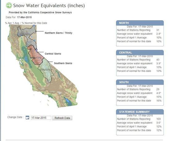
"This may seem like a benefit to backpacking…"
Not really… I expect fires and smoke to ruin the Sierra backpacking experience from late July on into September… what is normally prime time…
Sure you can backpack when there is smoke, but the views are gone, it stinks, and when the smoke is bad it will be very unhealthy… even dangerous to you health.
billy
there is a plan being discussed to build a huge pipe line from the Mississippi River to California.
problem solved …
@Art: Except the mighty Mississippi experienced its own drought a few years back, causing the Feds to dig (dredge) the bottom to let the all-important barge traffic sail.
http://mobile.nytimes.com/2012/08/20/us/in-midst-of-drought-keeping-cargo-moving-on-mississippi.html?referrer=&_r=0
Note it is dredged regularly but in 2012, more was needed due to drought. The states relying on the Mississippi were even eyeing the protected Missouri River. I think future megadrought needs to be factored in all these water movement schemes before taxpayer or ratepayer money is spent on pipelines from soon to be deserts to deserts. Same issue may affect the lower NM part of the Gila btw, so I am affected by western water issues too. ADD it made for some nice late winter backpack trips though!
Columbia is closer. Cleaner? If you ignore radiation from Hanford…
Although you were probably kidding (?), building a pipeline large enough to deliver any meaningful amount of water to CA is going to take upwards of a decade or more. Maybe someone can figure out Miss. river flow rates and see what it'd take to deliver a 63 trillion gallon shortfall…
The ship has sailed for a pipeline. If it was to come from anywhere it'd be from British Columbia. For those that have read Cadillac Desert, you'll remember the discussion about the mega dam project there.
No way that gets passed today.
The shortfall mentioned in the article abstract, and causing the uplift in California, is for all of California including the flora and fauna. In the big picture we are indeed short that amount, but water conveyance structures are typically only constructed to benefit human uses.
Over the years there have been many proposals to bring water into California from far away including the Columbia River, British Columbia, the Mississippi. None of those have gotten very far.
And rightfully so. The land can only sustain a certain number of people, farms, industry. Yet they keep approving more housing developments. Gotta keep housing prices low, or price increases cascade down the chain.
Good thing solar panels are coming down in price, that might balance the increased cost of water from desalinization.
Watching my 500gal in my rain barrels dwindle away,
Steve
> Gotta keep housing prices low, or price increases cascade down the chain.
Might be more relevant to say
Gotta keep the real estate and building companies booming because they bribe so many polis.
Cheers
The solution is simple.
Control human population.
"Control human population."
Mother Nature is just now getting around to it in her own deliberate, ineluctable way.
Become a member to post in the forums.
 New Ultralight ShelterFreestanding silpoly shelter for lightweight adventures.
 Loading...