Topic
Why it’s best not to rely on cellphone navigation when hiking
Forum Posting
A Membership is required to post in the forums. Login or become a member to post in the member forums!
Home › Forums › General Forums › Philosophy & Technique › Why it’s best not to rely on cellphone navigation when hiking
- This topic has 209 replies, 11 voices, and was last updated 4 years, 11 months ago by
 BlackHatGuy.
-
AuthorPosts
-
Jan 16, 2020 at 9:40 pm #3627485
This is all you need, boys—
 A series of good topo maps to get you from Point A to Point B—and—A simple call/text cellphone to call the Wife once a week to make sure she didn’t sell the house and move to Texas.
The drooling fascination with the holy Smartphone is ruining a whole generation of Americans—in my opinion—just look around—and the last thing I ever want to do on a backpacking trip is carry any device which allows me to get online. At home I’m a decadent slave to the InterWad—on a trip I’m permanently OFFLINE. No screen maps, no GPS, no live streaming, no FB, no blogging—A paper map is more than enough and has been for the last 40 years of hiking.
Jan 16, 2020 at 10:15 pm #3627487Roger,
Methinks there are many who read our posts very quickly. So now I understand why until lately your posts were quite short, sometimes with a picture or two. Bravo! Will try to crawl back up onto the wagon, unless posting about a completed MYOG project where folks are entitled to more explanation along with the photos. But please don’t stop with your comical remarks, or I will be forced to start posting cartoons again.Jan 16, 2020 at 10:34 pm #3627488Thanks Tipi for the perfect example of a post worthy of the OK Boomer response.
Jan 17, 2020 at 1:53 am #3627492Amazing how “passionate” people get over what others (often strangers) decide they want to use while hiking
Using extremes from each side is pretty pointless
Cell phone/GPS batteries do die, (has happened to me) but extra batteries or powerpacks offset this
Screens do break when dropped, (has happened to me) but rarely are they completely useless after, usually it’s a cracked but working screen
Water ingress is a concern, (has happened to me) there are many waterproof phones these day
Sure there are concerns and real world problems, but that’s also the same with maps
1/ It’s automatically being assumed there is good accurate reliable maps of the area you’re walking in, not the case for many areas here in Greece
2/ In strong winds, maps can be blown away, (has happened to me)
3/ Compasses can fail, air bubbles or inadvertently being stored near a magnet, (has happened to me)
4/ Like phones a compass can break if dropped or in my case accidentally stood on
5/ For longer hikes that can be a lot of maps to carry
6/ It’s a balance between carrying heavier bulkier waterproof maps, or easier to carry paper maps, not surprisingly paper maps aren’t much use when wet (has happened to me)
Using phones/GPS or maps, neither replaces the experience and skill of finding your way and map ready
Taking a map and compass doesn’t automatically mean you can read it, likewise using a phone/GPS doesn’t mean you can’t get lost, in both case situational awareness is as important as the device
Depending on the situation i tend to switch between and use both a map/compass and a GPS phone
My phone is also my camera, book, audiobook, music player and contact with my family
Unfortunately i also need to work, so having a phone enables me to work remotely and be outdoors rather than being stuck in a office all day if i didn’t have a smartphone
Each to the own though
Jan 17, 2020 at 5:26 am #3627498Amazing how “passionate” people get over what others (often strangers) decide they want to use while hiking…
…Each to the own though
Well said. HYOH. Everybody enjoy yourself and be safe. I’m taking my smartphone with a good hiking app as one tool to help prevent me from getting lost or re-routing if necessary much quicker than just a map alone.
Jan 17, 2020 at 7:55 am #3627505Ken – “Thanks Tipi for the perfect example of a post worthy of the OK Boomer response.”
My work is done. I’ve even got chief justice Roberts to use the phrase.
The only time I use the InterWad on my phone while hiking is to get a weather report. I don’t worry that I missed something important on BPL.
With the inreach you can send a preset message to that address and it’ll send back a weather report for your location as Doug suggested. That doesn’t require cell coverage.
Jan 17, 2020 at 8:30 am #3627513It does make me chuckle that folks think that taking advantage of the technology available is somehow sinful.
Somehow I don’t see the folks participating on this site being preoccupied w/ their “devices” like we have all seen in a restaurant or elsewhere. It’s simply a tool to navigate (and store maps, take photos with, make notes, etc); a tool that has many advantages over a map/compass. I also don’t recall anyone posting that they’ve thrown their maps and compass in the trash and exclusively relying on a smartphone-that wouldn’t be prudent. I’m a prudent person.
It’s an effective tool, nothing more. It’s not sinful :)
Jan 17, 2020 at 8:40 am #3627514By all means, HYOH.
That being siad, there is no reason to not take advantage of technology when and where it is prudent. While hiking in Iceland, I was glad to use GPX to navigate a trail during white out conditions in the snow. Cairns, a map and a compass would not have helped. My 2 cents.
Jan 17, 2020 at 11:25 am #3627554@ Jerry
“With the inreach you can send a preset message to that address and it’ll send back a weather report for your location as Doug suggested. That doesn’t require cell coverage.”
more please…. pretty please….. And feel free to start or address that reply to: “ok whatever”
that address: What address?
as Doug suggested: Where is that suggestion?
So I guess there is some address you can text and get a reasonably detailed weather report in reply? I know Garmin will provide a weather report on 2 levels with the more detailed costing extra. Is this some other service? I get the impression from prior experience/disappointment with Garmin’s higher paid level of weather report that they are using the GFS model which can be pretty good inside 60-72 hours (the report in the case in mind missed a BIG snowstorm @ 48 hours) and is quite often pretty far off (or far enough for trouble…) outside that time frame.
Now we can have a discussion about how you should be prepared for any and all weather no matter what OR you can rely on electronically reported weather and adjust accordingly OR you can try to do both and even if reasonably prepared still use information received electronically to get out of the way….. ok whatever
Jan 17, 2020 at 11:53 am #3627563@obxcola: This is the site Jerry’s talking about, I’ve talked about it before in other threads but not this one. Site is pretty easy to understand, and there is more than one report you can get depending on how you form your query, and you can use different weather reporting ‘agencies’ (for lack of a better term) – explained on the site.
Jan 17, 2020 at 1:20 pm #3627583thanks Doug, that’s what I was talking about, I tried to put details but the inreach website doesn’t seem to be working or I am just incapable right now
send the message “wx now” to “[email protected]”
I just made it one of my preset messages so it costs me $0.50 to receive the message
Maybe it takes an hour to get the reply
I’ve been using that a time or two on each trip
Jan 17, 2020 at 1:28 pm #3627585“Maybe it takes an hour to get the reply”
Depends on where you are. I’ve gotten a reply within 5 minutes, and at other times it might take 20 minutes. Never had it take an hour, I don’t think.
Jan 17, 2020 at 1:42 pm #3627590maybe I’m counting the time for the inreach to acquire satellites and so forth
Jan 17, 2020 at 4:03 pm #3627619Thanks a bunch guys! That’s some really useful info! I don’t seem to have managed to develop the knack of predicting the weather.
Jan 17, 2020 at 4:40 pm #3627628“No one here will think any less of you if you simply resist the urge to post an uninformed comical “opinion”.
Ah, but look how many other people have chipped into the discussion! Great involvement.”So you’re advocating posting incorrect information, or posting uninformed or misleading information, so that more people will get involved in the discussion? Interesting.
Jan 17, 2020 at 5:20 pm #3627637“Fake News, Fake News” …
Sigh.
None of the above, of course.What this discussion has highlighted is that there is a very wide range of opinions on the subject, and that most of these opinions are held quite seriously and honestly, and are mostly based on considerable experience.
By and large, none of them contain ‘incorrect information’, although there have been a few egregious extrapolations. Well, that happens on the web. Brains may be required.
I don’t think any of them were intended to mislead either, although some of them may have been meant to make the reader think again. That could be a definite plus.
I ignored the accusation of ‘uninformed’ as I think that most posters probably have quite a lot of experience, both with GPS and without GPS, and can make their own judgements.
I can live with the ‘comical’ bit.
Cheers
Jan 17, 2020 at 7:22 pm #3627646@Doug and Jerry and InReach weather: Ok I checked out that site and also followed the link from that site to the mountain weather site which can provide 24 hour forecasts for a specific peak and at a specific elevation! (if listed and looking at the listed peaks there’s one somewhere near most places you might get caught out in scary weather in the mountains) Really interesting. Looks like the InReach has all sorts of hidden potential, I’d already thought about using it in the same way Alan Dixon and Will Reitveld recommended using the old Garmin 201, 301 and the 401 series which is to mark waypoints on another program like Caltopo and then load them into the GPS device. I’ve done this with the InReach but didn’t want to hazard draining the battery so saved that stuff on trips as backup for maps and Gaia, but I’ve tested it navigating around home and on short trips and it works pretty much like a 401.
There’s a thread a few pages back now about battery life but I haven’t used more than maybe about 25% on 2 different week long trips so far and that’s with sending a routine 3 messages per day and getting the Garmin weather forecasts downloaded as seemed potentially useful. I don’t see battery life as an issue as long as you only turn it on for the daily messages and to get the occasional location fix. Wonder what other useful info can be delivered by satellite?
Anyone know what the satellite data transmission limitations are? Are they theoretically pretty large like the auditory signals sent by Sat phones? Or is the size merely set/constrained by Garmin and the subscription.
If you’ve ever tried to use the up /down arrows and so forth on the InReach to create a message you can see how that is a strong incentive to keep things short and simple! OTOH on my last hike there was a beautiful sliver of a crescent moon and I tried to attach the image to a text to my wife (crescent moons are her fav) using the mobile phone bluetooth app and that didn’t work. I guess the photo went wayyy over the limits in “Characters” Wonder if something like that might be possible on a per kb fee basis?
Jan 17, 2020 at 7:24 pm #3627647In my experience many (most?) smartphone users become nervous and upset when separated from their device. It’s an adult binky. They often grasp it compulsively for reassurance. Say you’re having a conversation with a friend at a restaurant and look away at the menu and when you look back your friend is holding his or her phone and looking into it adoringly. I used to take this personally but I’ve come to realize this is a universal behavior–smartphone people do this with everyone. they simply HAVE to peer into their phones; and when they’re not, they’re a tad anxious.
I wonder if the vitriol against Roger is based on the feeling that, if my phone is being questioned, I’M being questioned, discounted.
I mean, Roger doesn’t have a smartphone; neither do I. Big deal. Why the hate?
But I do wonder if people bring their phone into the wilderness because they’d feel lost without it–and yes, the double meaning is intended.
That will be $120.00 and I’ll see you next week.
Jan 17, 2020 at 7:37 pm #3627652This site really needs to allow more time to allow an edit or delete to occur. I already regret the last post. Of course I’m not referring to anyone here!
Jan 17, 2020 at 8:29 pm #3627656No need to regret the post, nothing in there incendiary. Honest questions, no problem with that. I’ll try to maintain that with a reply.
I have no ‘hate’ or ‘vitriol’ for Roger, and don’t see that from others, so I think your use of those words is a bit over the top. In my case anyway, I think minor frustration is more apt, but whatever.
So why the minor frustration? Because it seems Roger has a real issue with simply admitting he doesn’t really know what he’s talking about in some threads. When called on it, he changes the subject or simply doubles down, but in the process he’s adding confusion to something that doesn’t really need that. If you don’t really know what you’re talking about why not just admit that and bow out of the conversation?
I don’t care that he doesn’t own a smartphone, I don’t care who does or doesn’t own a smartphone. It doesn’t seem to me that most folks talking about how useful they find a phone with gps apps in this thread are people who are tied to their phones – they simply see them as another useful tool in their toolkit.
Only $120? Damn, you’re cheap.
Jan 17, 2020 at 8:34 pm #3627657I don’t think that this is fake news.
Jan 17, 2020 at 8:40 pm #3627658I kind of like the armchair psychoanalysis of compulsive cell phone users. Glad you didn’t delete. Hard to take any of it very seriously. Use a phone if you like and have a plan B.
Im still sad Geraldine didn’t. She seemed like a wonderful lady with more to give to the world.
Jan 17, 2020 at 9:09 pm #3627662Karen interesting info about the gps jamming exercise. Looks like the AT from Springer all the way to Winding Stair Gap in NC near Franklin might be within the specified range of possible jamming. Pickens Nose, what a view! On a clear day seems like you could see Cumberland Island from there.
Jan 17, 2020 at 9:20 pm #3627666when you look back your friend is holding his or her phone and looking into it adoringly.
Now that is an image I will not be able to forget. Marvelous!it seems Roger has a real issue with simply admitting he doesn’t really know what he’s talking about in some threads. When called on it, he changes the subject
Chuckle. Why pick on only me?But I would be interested in seeing a list of threads I have commented on where I do not have some knowledge of the subject. Do tell, please. (Be prepared for some dispute though.)
Or could it be that my Australian humour is being seriously misconstrued or misunderstood? That does happen, I know, I know.Do I really change the subject, or is this a good example of two people talking past each other? Or perhaps of my sticking to MY subject and not being waylaid and diverted, by someone else’s agenda? I can see that creating some frustration.
In the present case I present the following evidence:
* I have been happily (and successfully) navigating by map and compass in very difficult terrain and weather for well over 40 years.
* I have tested a couple of GPS units and found that they have all given me serious errors at times. In one case the GPS put me several hundred metres out into an estuary, while I was on the bank.
* Some of my friends have had similar experiences. One of them showed my his latest GPS track – it ran half a kilometre to the side of the major road he was driving on. In another case, recorded here at BPL, someone in a canoe had a GPS track which occasionally went a km or two up the hillside, and then back down.
* Fwiiw, we do know the technical reasons why these sorts of errors happen. It can be the software in the unit or it can be problems with the environment (eg cliffs).Cheers
Jan 17, 2020 at 9:22 pm #3627667the gps jamming exercise
I wonder: will the military or the local SAR be posting warning notices at each end of that section?Cheers
-
AuthorPosts
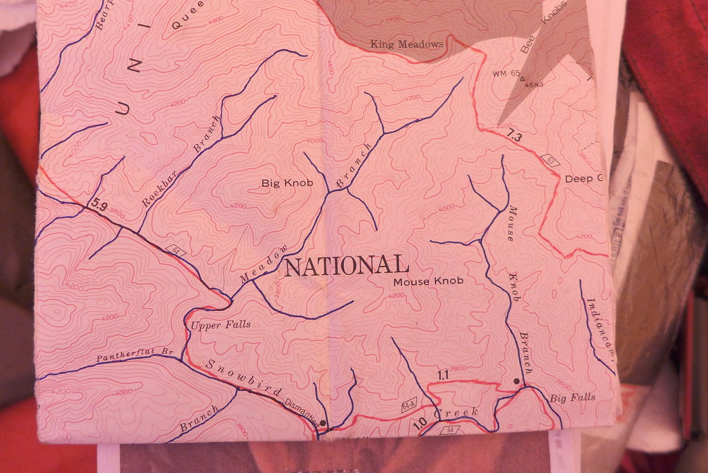 A series of good topo maps to get you from Point A to Point B—and—
 A simple call/text cellphone to call the Wife once a week to make sure she didn’t sell the house and move to Texas.
- You must be logged in to reply to this topic.
Forum Posting
A Membership is required to post in the forums. Login or become a member to post in the member forums!

Our Community Posts are Moderated
Backpacking Light community posts are moderated and here to foster helpful and positive discussions about lightweight backpacking. Please be mindful of our values and boundaries and review our Community Guidelines prior to posting.
Get the Newsletter
Gear Research & Discovery Tools
- Browse our curated Gear Shop
- See the latest Gear Deals and Sales
- Our Recommendations
- Search for Gear on Sale with the Gear Finder
- Used Gear Swap
- Member Gear Reviews and BPL Gear Review Articles
- Browse by Gear Type or Brand.
