I was going to us a 5.9 oz tarp and 7.3 oz bivy. But my mountaineering brother offered to loan me a 14oz GoreTex bivy. I'll probably pair that with an 11 oz snythetic quilt and maybe something to keep the rain off my face. The ability to crash anywhere with minimal set up is appealing.
Topic
2015 Bob Marshall Wilderness Open
Become a member to post in the forums.
- This topic has 343 replies, 28 voices, and was last updated 10 years, 5 months ago by
 .
.
Actually Dave I am not planning on bring a sleeping bag or tent.
I thought about it a little more and figured I can always bring along a clear shower curtain as a tarp so I can watch the stars twinkle ;) With any luck this year I won't have to bevy in a tree well at 8000 feet
I'm jealous of all you Montanans. The Bob is an alien world to Alex and I and frankly, a natural fear of the unknown is going to likely lead to an over-insulated, over-accessorized, over-sheltered kit. Greg, are you going to bring a sleeping pad?? Are you relying on your puffy/insulated pants for warmth? A hot water bottle inside your Gortex bivy? Sit-ups every hour on the hour?
Hello Chase. I don't bring a sleeping pad but to be frank I usually look for a good spot that has either (dry) moss for bedding or I make a ground cover out of spruce branches (old school). The other thing is that if the ground is soft, but wet, I'll inflate my raft, turn it over and sleep in it (best option provided you check for sharp objects and don't get crap into the valve stems). As to your question about "puffy insulated pants" I keep a separate set of dry sleeping clothes inside of a water proof stuff bag. I prefer wool for my sleeping shirt, sleeping long johns, wool socks and hat. Bivy bags usually cause moisture build up inside of them (the Gortex ones don't) so odd as it may sound I sleep in my rain gear. It keeps me dry on the inside and I don't care if moisture builds up on the inside of the bivy bag. It also helps that my metabolism tends to run a little warm. As to your question about hot water bottles, I don’t use them, but.., For years I have carried what I call an emergency hypothermia prevention kit that uses military MRE heaters (Derek is laughing right now) which I place into a small foil covered bubble wrap pouch that is about 6” wide by 12” long. The heaters will last up to 30 minutes when activated and the whole thing weights about an ounce. The heaters weigh a few grams. For the 2011 Alaska Mountain Wilderness Challenge I had a partner who took a bad fall on a glacier, got hurt and within a few hours was suffering big time from the cold and snow that descended upon all of us during day 2. The snow went on for 24 hours (Dave recalls). We could not stop his shivering until I pulled out the kit. You place this under your left arm pit and allow the heat to transfer to the blood nearest the heart. Works well, weights almost nothing, takes no fuel and does not require a fire.
Greg, I actually laughed about the MRE heater tip, and will never look at an MRE the same.
Other things on my mind:
– Are the pack bridges across the South Fork & Little Salmon intact all year long or are some of these seasonal?
– Anyone use Hammer Perpetuem? If so, what method do you use to consume it (make a paste, etc.)?
After reading some of these shelter ideas, I'm beginning to wonder if my Montane Minimus top/bottom will make a sufficient shelter for the few minutes of sleep I plan to get (as long as I have enough MRE heaters to place on my body).
Chase, the Bob isn't so different than any other place. It's a good combination of PacNW forested canyons in the western part, and forested midlands and Yellowstone-esque sage valleys in the eastern part, with some rugged rock alpine areas sprinkled around. It's a complex and varied place, but not especially hostile to travel. Doing this sort of traverse in the Selway-Frank Church complex (which I've considered) would be a lot kess fun because rougher country would force everyone into fewer route choices.
Greg is a hard man. Re-read his 2012 report, then read it again after you get back home in May. Sufferfest for sure. I went without a sleeping bag that year, and in the Wilderness Classic both times I've gone up. I don't recommend it, not really because it shaves too much off your safety margin, but because it removes a huge part of your psychological safety net. Sleeping for 90 minute stretches around a fire under a tree is surprisingly restful, but it is intimidating. It's also not much fun. The last two years in the Open I brought full camp gear, and did not regret it.
The Cairn maps give current info on bridges. I know of no seasonal suspension bridges in the Bob. The old FS maps show a few bridges which no longer exist, and relying on such a false positive could really put a kink in your trip.
Hilarious. that's wheat I've been calling the BMWO; "Sufferfest 2015."
Good info. Thanks, Dave. That's reasurriung. Feeling better about my 17lb, full 4-season kit knowing the terrain isn't too inhospitable. There are few "psychological blankets" in my kit I could very likely do without but they're just that.
There's no doubt that, post Suferfest 2015, I'll have some invaluable data as it relates to the actual terrian, weather patterns, water CFMs, snow quality, etc. to use for the next traverse. Heck maybe you'll find me tarped under a clear shower curtain next year on a pile of dry moss, with no puffy! That's so core. Greg, you're a warrior.
Re: the pack bridges, here's a picture of a typical bridge in the Bob.
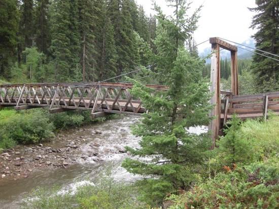
This particular bridge is over the S. Fk of the Sun just north of Benchmark, so not a bridge anyone is likely to use this year; however, it does give you an idea of what they are like. Very substantial and high enough off the water not to be in any danger of being washed away.
Incidentally, I would also like to make it clear that the pack bridge at the end of Big Salmon lake is over the Big Salmon creek., the one just north of that crosses the Little Salmon creek, NEITHER crosses the S. Fk of the Flathead. Cairn map has this clearly indicated, but for years I thought those bridges were crossing the Flathead from looking at the FS map, which is not as easy to read.
Dan
So…(I know I'm going to get hammered for this, but what the heck)…any thoughts on a BMWO t-shirt?
You bring the shirt, I'll bring a sharpie. ;)
In all seriousness, ain't gonna happen. I don't think I need to elaborate. (first two rules…)
Snowmelt around here continues to be just weird. We've seen no significant low and mid (<6500 feet) elevation snow accumulation for months. It's been sunnier than usual for the last two months, on the warm side but never hot. Snow has been melting, but mainly because of solar exposure rather than temperature. The snow has been going away, and fairly quickly, but in a rather idiosyncratic way.
Glacier Park's Flickr page is a good resource for monitoring the snowpack as well. You can click back to previous years and cross reference to evaluate how 2015 stacks up.
just peeked at the Badger Pass snotel site, 62" of snow (6900') as of today, so there may be a couple of inches left in May :)
Still trending toward a light year though…
April 7th:
2015: 64"
2014: 107"
2013: 78"
2012: 99"
I noticed yesterday that the metering station for the SF Flathead River at the Hungry Horse Reservoir was running at over 212% of normal flow for this time of year, looks like the snow is leaving. Mountain bikes this year?
yeah- it definitely looks thus far spring is coming earlier than normal
Is too early to start extrapolating water volumes at major junctions with the trail? Please excuse my ingnorance in the matter but one could infer CFS volumes correlate with snow melt data and river fords should be historically "easy"…right?? Wrong? Surely the thought has crossed many of our minds: "Will a packraft be useful for some of the more modest crossings?" Or… "Am I prepared to swim?"
Generally, you should pay closer attention to melt rates in the 3-5 days leading up to the start. If the weather cools off at higher altitudes in the days before then the melt rate will be less and the streams easier. If the temps stay warm then the flow rate will be elevated. Right now the stream/river flow rates are abnormally high (relative to the time of season.. keep in mind that they are right now they are only 1/3 the flow rate we had in late May,'13).
It helps if the majority of the snow pack has dissipated before late May, but that should not be misinterpreted as equating to low stream crossings in late May, that will only be the case if the higher altitudes have cooler weather that weekend. I am starting to think that crossing mountain passes is going to be easier; however. (And I was joking about mountain bikes by the way :)).
Chase, that's a highly relevant and somewhat complicated question. I'd also say, as something of a hint, that stream crossings should be the #1 concern on this particular course.
Greg is correct that temperature, sun exposure, and precip in the week leading up is taken together the most relevant factor. However, meltoff in the months leading up heavily affects the potential of a given drainage to rise under the influence of those climactic factors.
For example, I think everyone who went over Sun River pass in 2013 was concerned about fording Strawberry Creek. It's a fairly big drainage and we were crossing it right at it's base. I was surprised when there was hardly enough water to float my packraft, and even more surprised when streams lower down (Lodgepole and 25 Mile) were significantly higher than Strawberry. It had been clear and warm for a while leading up to that weekend, and the Strawberry drainage primarily faces south and is mostly burned timber, so I think it melted out sooner and thus had less water to give. Compare that with Strawberry last year, when it had much more snow in the headwaters and was 4-6 times bigger at the same ford.
So generally, early melt like we're having in NW Montana this year will make things easier out there, in terms of generalizing towards lower streams levels as well as less snow slogging, but does not necessarily guarantee it.
We go through this exercise every year :)
A month or two before the event everyone looks at the flow gauges and flip out at how much water is moving. The data a week or so out gives a better idea, but in the end you just have to show up an see for yourself how high the water is. Similarly with the process of judging how much snow will be encountered.
It's never entirely what we expect. I've accepted that there will be surprises, and budget time and energy to deal with them.
All the data just helps me answer the fundamental question: will the fords (or snow, or weather) this year suck more, or less, than previous year's attempts?
Any bets on if/when the snow depth at the Badger Pass Snotel Site will fall below 50"? (I think some of you locals are hiking out there and shoveling snow over the sensors). I wish I had never learned about the NRCS website.
By the way, I'm looking forward to catching a few fish after Memorial Day somewhere on the reservation, possibly at Duck Lake. If you have a better spot, please feel free to provide your top-secret fishing hole location in a PM…along with your primary, secondary and alternate BMWO routes.
I'd say fairly soon, as it's supposed to crack into the 70s here in town the next few days. Badger is good because in many ways it's a worst-case example; fairly high, in thick forest, and north facing.
I was down in the Blackfoot over the weekend, and on south facing slopes things were clear all the way up to 6500'. The Holland Gap, looking from the highway, looked melted out at least up to 6k.
as Dave mentioned somewhere earlier, snow pack is down, but moisture content is near normal and what I’m seeing is high elevation snow hanging on pretty well thus far- low to mid elevation snow is quickly becoming extinct
I was in the Rattlesnake Wilderness (near Missoula) Saturday up to Stuart Peak- I was snowshoeing at about 6000′, near the peak snow depth was at least 6′
on a side note, the Shift snowshoes did really well, found a little powder where they sucked, but overall pretty damn good :)

Hey everybody,
As we get closer to the event, there is a wrinkle regarding the end point that I wanted to make sure the non-locals know about in advance (don't think I'm giving anything away here regarding routes, since it involves just the trailhead).
The best place to park at Swift Res. is on the north side; however, that land just happens to be the very southern edge of the Blackfeet reservation. They have a rule that non-tribal folks are only allowed to 'recreate' on tribal lands (yes, that includes parking) with a permit. The permit fee is $10/person and, lest anyone get too irate for paying that much to park in a meadow, it actually is good for a year from 3/1 to 2/28 and allows hiking on any tribal lands (not much use if you don't live here, I'll admit).
I called the Rocky Mountain Ranger District (406-466-5341) office to confirm this is the latest info — some guidebooks claim that a deal in immanent with the state to allow parking there without the permit. Hasn't happened. Although, I have to add that the Rocky Mtn RD is the friendliest ranger station staff I've ever talked to. The receptionist offered three locations where a permit can be found: the Blackfeet fish and wildlife office in Browning (406-338-7207), Teeples IGA in Browning (406-338-2165), and Bear Track convenience store in East Glacier (406-226-5504). They're all pretty much on the way when doing the shuttle; although I personally would lean toward the last option as they are nice folks and have a plethora of junk food for the post-hike binge. I believe the permit is also available a couple places in Kalispell.
It is certainly possible to park on the South side of the reservoir too, without a permit. There's a big, open field/campground; and, although there may be lots of people there for Memorial day, probably still plenty of parking space. The hitch is that parking on the south side entails a ford of the river just as it's becoming the reservoir, then an extra 4 miles or so of trail. The trail's not a problem, but I would worry about the height of water at that place, even with this likely low-water-level year.
So… your options are: 1) Get a permit and park on the north side. 2) Screw the permit and take your chances parking on the north side. I did this once, but it was about 12 years ago, before I knew about the permit requirement and nothing happened. Seriously, I'm not sure the Blackfeet Tribe actually pays someone to check on these things, but I'd hate for someone to take that chance on my word and get in trouble (no one seems to know what 'trouble' would actually occur if you were caught). 3) Park on the south side and take your chances with the ford. The map seems to indicate an option to cross upstream a bit, I don't recall seeing that, but as I say, it was many years ago. 4) park on the south side, but hike out on the north side dirt road. This might actually be the best plan. It just irks me to hike a couple miles of road that I could have driven, especially at the END of the hike.
Hope that is sufficiently confusing and I also hope I haven't spoiled a detail Dave was planning to share in due course. Let me know if you have questions, or Dave, tell me to shut up if that is called for.
Thanks,
Dan
The "official" finish is the south side TH and campground. It did not occur to me that anyone would think otherwise, but I'll make that more clear in the relevant spots. I'd strongly encourage anyone leaving a vehicle to leave it there. Loads of parking is available. How you get there again on foot is up to you. :)
Oops . . . Nevermind.
Well, at least there were a couple of useful sentences in that epic.
Become a member to post in the forums.
advertisementYour privacy is protected: We do not transmit your user data to third-party ad platforms or advertisers, and we do not host third-party tracking pixels. Backpacking Light serves ads on its own custom, native, and internal platform.
 New Ultralight GearSee the latest releases in ultralight cottage-brand gear from small makers.