Great stuff, Tanner, congratulations. I particularly like the line, "I saw some of the finest mustaches I’ve ever seen." and the photo of you up in the snowy high country. Awesome!
Topic
2015 Bob Marshall Wilderness Open
Become a member to post in the forums.
- This topic has 343 replies, 28 voices, and was last updated 10 years, 5 months ago by
 .
.
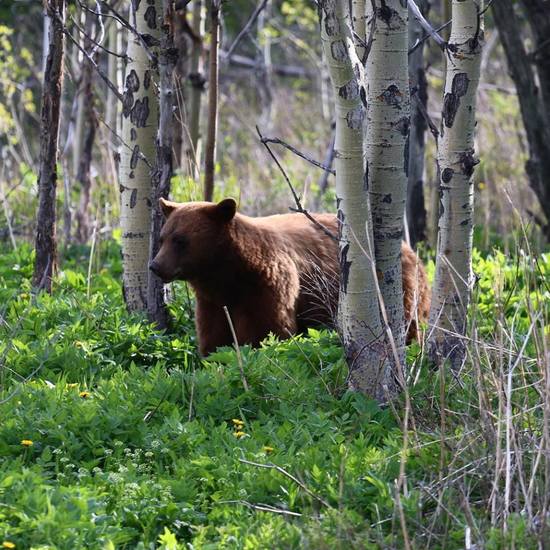
Not long after my BMWO, I did get to take of a photo of this little bugger, so all was not lost:
Great Write up Tanner, you seem to be a bear magnet! I too loved the line about "I saw some of the finest mustaches I’ve ever seen." having spent the spring growing a set of Bob Bars for the occation!!
Tanner- great report and way to rock it man! I'm glad you were able to placate all the bears before we arrived :)
Mike
My report: http://bedrockandparadox.com/2015/05/29/my-2015-bob-open/
I like to talk about moving this elsewhere, but the location and time work out so well I probably will just never be able to do it. I've only been through the country east of the main North Fork Blackfoot once, so that's what I've got my eye on. Suggestions for 2016 welcome.
great report Dave! I found it particularly interesting that you were able to benefit from Mr Griz's knowledge of the trail system :)
I'm not familiar w/ previous years ending/starting points and disregard if this has already been done, but maybe a NW (Great Bear-ish) to SE (Scapegoat-ish) or vice versa, would prove interesting???
Mike
OVERVIEW
My intent the last few weeks leading up to the BMWO was to engage a shorter route than most participants were contemplating, mostly to eliminate transportation issues. In hindsight I am happy with this plan; five days was plenty for me and it was all new-to-me country. My previous Bob Marshall backpacking experience has been in the warmer months, a five day trip in the Swift Dam area, a four day trip to see the Chinese Wall, and an earlier aborted two day trip to see the Chinese Wall (cut short by cruddy weather). I have also nibbled around the eastern and western edges on day hikes.
Justin and Morgan agreed to accompany me on the first part of the trip. Thanks gents, I enjoyed the company.
I planned five days for this trip. That turned out to be just right.
i spent Friday night at home and drove to the TH Saturday morning. I talked very briefly with Dan D. and said hello to Mike M. (admiring each others' packs). Of course I met Justin and Morgan and eventually met Chase and Alex while on the trail. Greetings to everyone else! If I participate again I will make a better effort to attend the meet and greet dinner so I can attach names to faces.
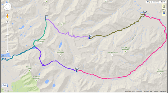
My Route, Counterclockwise:
DAY 1, Saturday, May 23
Owl Creek TH to Shaw Cabin, 13.6 miles (mileages from GPS data logger)
The first ~6 miles were unremarkable then we hit snow above Upper Holland Lake.
Morgan and Justin set the pace and did the route finding up to Gordon Pass. The trail was buried in snow, not easily visible at first. It was not long until we did find the trail and it was fairly easy to follow. They carried no snow shoes, I carried some runner's snow shoes, which I put on shortly after starting up hill. My 'shoes provided decent floatation but poor side hill gripping power. Overall snow shoe usefulness for the day would be graded "C minus". Rain jackets were worn while going up to the pass and were removed on the other side of the pass.
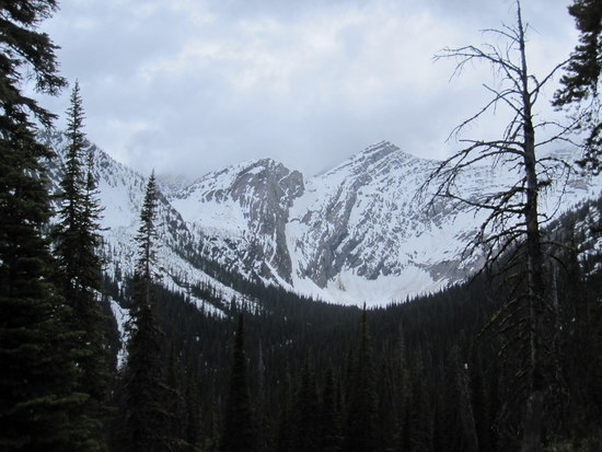
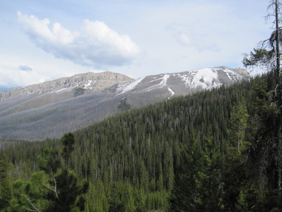
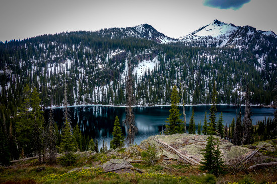
The views in The Bob can be less than stunning, though always very pleasant, for many miles on end so I was very pleased when I got to the top of Gordon Pass and saw some rugged snowy mountains. It was time to take a few pictures and to savor the moment.
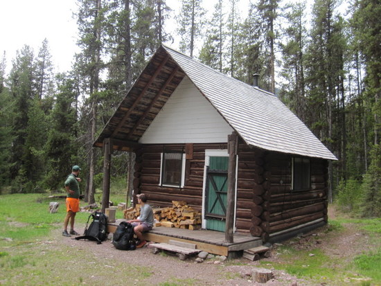
We set up camp at the Shaw Creek Cabin. I was ready to stop for the day; I think my companions wanted to go a little farther so I thank them for humoring me. There is a large flat area for pitching tents, a good stream for water, and an outhouse. Justin cooked a great looking meal over a wood fire.
DAY 2, Sunday, May 24
Shaw Creek Cabin to Mouth of Bartlett Creek, 17.2 miles. Minimum overnight temp 33F/1C.
On the previous night Morgan suggested that I might leave early in the am and that they would catch up later in the day. Youth vs. age, faster vs. slower. I was hoping to reach Young's Creek and take a nap while the boys caught up. Unfortunately, they caught me about 1 1/2 miles short of Young's and I did not get my nap.
There was ample evidence of bear activity along Gordon Creek. Tracks and poop. Unfortunately, there was also ample evidence of litter. Someone's torn/leaking garbage sack?? There was little sign of litter the rest of the walk. I picked up a few pieces but walked past most of it.
I saw occasional human tracks in the mud. I am very disappointed not to be the first to walk Gordon Creek this spring (tongue in cheek). Update! I see that Mike M. and buddies took this route–mystery solved.
Many miles of the Gordon Creek trail consisted of dry mud that had been heaved into an unlevel mess that made walking more difficult than it should have been.
We proceeded down to the pack bridge at Big Prairie and ran into Chase and Alex. Great timing! The looming decision about when I would become a solo hiker and leave Justin and Morgan became clear and easy. They wanted to head north another ~7 miles that day and I was tired, ready to stop but did continue solo another two miles up the west side of the So. Fork of the Flathead River.
My original plan was to continue north and take the Big Salmon Lake route back to the SW. Somehow this seemed less attractive now and was definitely longer so I consulted the Cairn map and noticed that the Bartlett Creek Trail was labeled as "FS: System Trail Primary, usually maintained". That was good enough for me! With no further planning I decided that was the route for me. Ooooooops, that turned out to be a hasty bad decision for two reasons, one of which was forseeable. The forseeable aspect was that the trail reached a high point of 7500 feet which meant lots of snow, invisible trails, challenging route finding. I am getting ahead of myself and will address this in the Day 4 writeup.
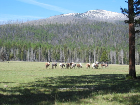
Back to Day 2. I somehow lost the trail as I approached Bartlett Creek. I scrambled down a cut bank, found a decent looking crossing point and waded across. For one brief moment I partially lost my balance in the swift moving knee-high water. Once across I filled my water bottles with both drinking and cooking (unfiltered) water since I had no intention of coming back again later, then I bushwhacked uphill to find a flat spot to camp. Wow, did I ever find a flat spot to camp. A huge meadow (maybe that is the Big Prairie?)
View from camp site, pack train:
DAY 3, Monday, May 25
Foot of Bartlett Creek to Obscure Location , 8.5 miles. Minimum temp 29F/-2C.
After a false start, heading in the wrong direction, I got on track and headed up Bartlett Creek. It was a warm morning and the shade was welcome. The shade did not last long, however, since much of Bartlett Creek is in a burned area. Remember a few paragraphs ago I mentioned two reasons that Bartlett was not a good choice? Number two: the quantity of downed trees was a relentless character builder. It may be a well-maintained trail later in the summer but this early in the season……. I thought Gordon Creek had a lot of downed trees but this had many more. Of course there are downed trees off the trail, too, so it was very difficult to make any speed. This was one of the toughest ~9 miles I have walked. I broke one of my GG LT4 poles while going around a fallen tree.
One good thing about Bartlett Creek was the fact that I was able to keep my feet relatively dry all day long! What a rare pleasure in The Bob. More on wet feet near the end of the story.
View from Bartlett Creek Trail:
I was beat after a short-mileage day and was looking for a place to camp. Nothing up ahead looked good on the topo map, nothing looked visually good as I walked along. I was determined to stop at the first quasi-usable site. I spotted a very small shelf just downhill from the trail. I dropped down to the shelf (that is a very kind description) and set up camp as best I could. My pad's length was perpendicular to the fall line and I stuffed various items under the pad to slightly level it out. The main saving grace of this site was a small tree on the downhill side which braced my upper right arm and right side while I tried to sleep. There was also a rock at my feet which served as a good reference point (I could feel it through the sleeping bag) that I was more-or-less in proper position. I could envison myself pivoting around the tree in the middle of the night and becoming a human sled. Luckily there was no snow. I pitched my SoloMid in tarp mode just to have some rain protection, probably the goofiest SoloMid pitch ever.
DAY 4, Tuesday, May 26
Obscure Location to Pendant, 7.9 miles. Minimum temp 39F/4C.
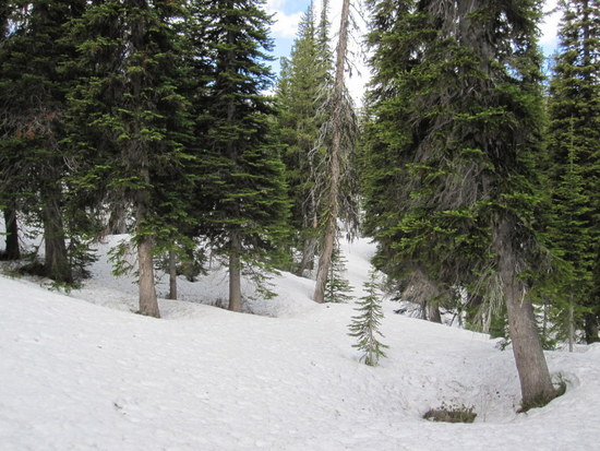
This was the most enjoyable day of the five. My hasty and poor decision about choosing this high elevation route was about to pay a dividend in spectacular scenery and route-finding fun. I ran into considerable snow at 6800 feet and the trail was completely covered. I wandered around for a while, looking for the trail. Hopeless. It was time to rely on map and compass. I also carried and used a tiny non-mapping GPS that gives latitude/longitude which backed up my compass findings.
Off to the headwaters of Bartlett Creek! I strapped on the snow shoes and followed the general direction of the mapped trail. This was an enjoyable stroll through a snowy wonderland. I was able to cross Bartlett Creek on a snow bridge. I was hoping to find a tiny lake to use as a compass reference point but I never did find it. Looking at zoomed-in GPS tracks I can now see that I passed within a few feet of the lake and did not see it! I proceeded to follow the general layout of the trail northwest then back south to the saddle between points 7950 and 7800. The portion of the walk headed south was a little sketchy and an ice axe would have been a wise precaution. My original idea was to head straight up the hill from the lake to the saddle, thus avoiding the nasty side hill. FWIW if anyone ever heads the opposite direction you could enjoy a heckuva glissade down from the saddle.
Where is the trail?
Thermal feature?

Let me emphasize that I was lucky to hit the snow conditions that I did; spring snow, one or two inches of soft snow on a harder base. There was no sign of snow pack instability but under the right conditions of a fresh deposit of snow it could have been scary.
At the saddle I took another look at the map and headed NW to the next trail junction. I picked up the trail after about one minute. Still lots of snow but enough bare patches to occasionally see the trail. The rest of the route to Pendant was routine except for breaking my other hiking pole in some rotten snow when my feet unexpectedly slid forward while the pole was planted. Both poles now broken.
Big Foot:

I was hoping to push on past Pendant before camping but Pendant Creek had me scratching my head. I just couldn't face crossing it in my tired condition. It was moving fast and seemed to be over knee deep. I scavenged the woods and found two sturdy branches that I turned into hiking sticks and tucked them away for the next morning. I would sleep on the issue.
Pendant Creek Crossing Point:
DAY 5, Wednesday, May 27
Pendant to Owl Creek TH, 10.6 miles. Minimum temp 35F/2C.
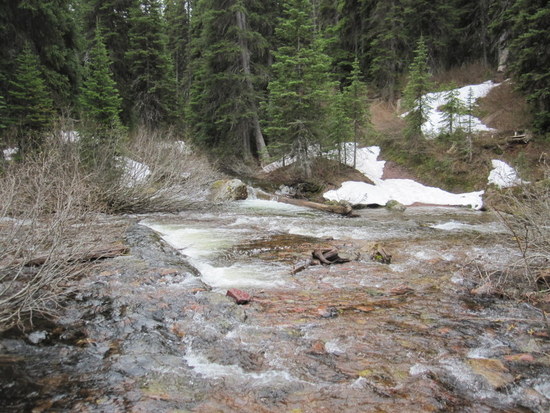
Time to face the Pendant Creek crossing. I went down to scout it one last time. The previous night I had made a mental note of the water depth in relation to a piece of conduit. This morning I did the same. The water level had not changed as far as I could tell. Isn't there an old axiom about water levels being lower in the morning? Maybe that is only an old tale. I pressed onward to see what I could see downstream and there it was! A beefy large tree was spanning the entire creek! Happy days. I was able to butt-scoot my way across and had only one more obstacle to face: the ascent of Pendant Pass.
Bridge Tree Across Pendant Creek
I saw some indistinct human tracks in the snow above Pendant Creek, probably made four days earlier and presumably leading to Pendant Pass. I eagerly followed them but eventually lost them and chose to avoid two more stream crossings by traveling south rather than north of the Pendant Lakes. It was a little side-hilly but not bad. I used the snow shoes on the lower part of the trail but took them off for the upper portion. The 'shoes came in very handy for floatation in this area. Grade "B+" for usefulness.
It was difficult to impossible to see the Pass from my route (due to the trees) so it was time to consult the map and compass again. Well, I was pretty close, just a few hundred feet east of the trail and pass. I corrected my route, dropped over the pass, and headed down hill to Upper Holland Lake.
The rest was just plain old walking back to the car.
WILDLIFE
Deer
Squirrels
Ground Squirrels
Grouse
BOTHERSOME PESTS
The mosquitoes were slightly pesky on three occasions. Once I donned my head net for about thirty minutes then removed it. They were not a big issue.
I found three ticks on my legs on Day 3. Found one more on the day after I got home. I was wearing pants and shirt treated with Sawyer Permethrin. Maybe I did not use enough?
FLOWERS
This is not a comprehensive list, I saw many whose names I do not know.
None were in great quantity except for the Glacier Lilly in some areas:
Strawberry
Glacier Lilly
Forget-me-not
Indian Paint Brush
Larkspur
Clematis
Starry Solomon's Seal
Lupine
Shooting Star
Less certain but possibly:
Waterleaf
Jacob's Ladder
Elegant Death Camas
Arnica
WET FEET
I have always thought that The Bob was wet foot heaven. It did not dissapoint again this time. On this occasion I used mostly thin neoprene socks with shorty liners. I experimented this past late winter with thicker neoprene socks. My feet just don't seem to care what I wear. Wool works fine, too. I did tape my big toes and the balls of my feet on day three. The tape fell off on day 4 and I did not bother to replace it. I felt some hot spots but no blisters developed.
EQUIPMENT
I am fairly happy with my equipment. I don't fault GG for the hiking pole failure. My snow shoes were not appropriate for the conditions and I may have to look for some MSR Shifts (sized for kids) that seem to be popular with some BMWO participants. I see that Northern Lites also has kids' snow shoes. I carried one extra piece of unworn clothing, a fleece hoody. Somewhat surprisingly I never wore gloves or the glove overmitts. I used some of the extra clothing for additional sleeping bag warmth on a couple of nights.
Perhaps someday I will be brave enough to post my gear list. Facing the scrutiny would be agony! One thing I might get ripped for is the carrying of two GPS devices. One is a data logger , Qstarz BT-Q1000XT, weighing 2.7 oz and has a battery life of 40+ hours. I swap out the used battery (0.8 oz.) every three days. The other is a simple GPS (Porter 102+) that has many functions but I primarily use it for Lat/Lon information. It weighs 1.5 oz. and is charged via USB cable. It is typically turned on for a few minutes at a time, the battery should last a long time.
TRAILS AND SIGNAGE
Not all the trail intersections were marked as best I could tell. For example, Trails 129 (Bartlett) and 263 just west of Big Prairie were not marked that I could see. Also not marked was the intersection of Trails 129 (Bartlett) and 131 (Holbrook). Then again, I am half blind..

MISTAKES, REGRETS
Not many. I bit off and chewed the right amount. I neglected to take photos in the uppermost Bartlett Creek headwaters for which I could kick myself. Wish I were young enough to keep up with those who are 40 years younger!
Edit to correct photo order and to reinsert inadvertent text truncation.
Great stuff John. Sounds like you had the full experience.
A lot of hiking poles (5?) bit the dust this year (You x 2, Me, Dave, Greg).
Tanner: I just finished reading your report. Thanks for writing this up. You'll look back on it in a few years and love having such a high quality trip report.
Wow you saw a lot of bears/wildlife compared to me. Nice stuff. Your route covered a lot of awesome country. I was impressed with your off-trail shortcut into the MF Birch. Genius call.
Nice meeting and hiking with you.
I noticed this photo (by Dave C) in his Bob packrafting BPL article this week:

It stood out to me because it's the spot where I flipped on the SF Flathead in 2013. It was neat to see this spot at lower water, because in both 2013 and 2015 all of these entrance rocks in the mini-gorge were hidden under water. I had no idea it was like this.
This year I was nervous coming up to this spot. I eddy'd out on the right (where the sand bar and Dave's raft is in this photo). I gave it 10 seconds of thought, and decided to run to it. I won't spoil the trip report (coming tonight or tomorrow) but it was still an adventure coming through at 6000 CFS.
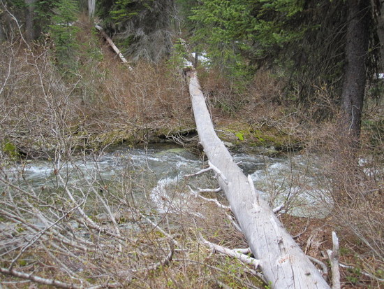
I wonder how many years that tree will last?
I'm psyched so many people showed up and put up, and found different ways to push themselves and their learning. That's what it is all about.
Litetreks are fine poles, but for summer and trail use only. I missed having two poles, quite a bit. Only gear shortcoming for me.
Those micro-gorges in the lower S Fork are spooky at higher water levels. The runouts are good so swimming isn't high consequence, but the hydraulics can be intimidating. I'm not a big fan of that section above 5000 cfs.
Historical documentation of the Bob Marshall Wilderness Open.
2009 – Parcour de Wild (precursor to BMWO hosted by Ryan Jordan)
Rogers Pass to Marais Pass
2012 – Bob Marshall Wilderness Open One
Teton River Bridge to Hungry Bear Saloon
2013 – Bob Marshall Wilderness Open Two
Benchmark to Bear Creek
2014 – Bob Marshall Wilderness Open Three
Marias Pass to Monture Creek
2015 – Bob Marshall Wilderness Open Four
Holland Lake to Swift Reservoir

Interactive map:
http://samh.net/backpacking/media/maps/bmwo/bob-marshall-wilderness-open-history.html
KMZ file:
http://samh.net/backpacking/media/maps/bmwo/bob-marshall-wilderness-open-history.kmz
John nice trip report, sounds like a grand adventure! I do have to say you have really good taste in packs :)
Sam- nice maps! thanks for putting that together
I think you'd like the Shifts, they have pretty good grip on them- I have a lighter pair of running snowshoes (Atlas Race), but other than the foot crampon itself, they have about zero traction- great for running, not so great for ascending/descending mountains
I'm using BD carbon Z poles, not sure what the weight difference is between them and the GG's and the like, but I've use them hard for the last two winters snowshoeing (w/ their small snow baskets), maybe I've just been lucky, but they seem pretty darn tough for their 10 oz (pair) weight, the ability to fold them and stow them on the go is really nice for when I use them running
Sweet map Sam. Bear Creek needs to be ~15 miles west right under the 2.
I have been wondering exactly where that point was since I added that line to Google Earth prior to the start of that year. I'll update, thanks.
I'm not sure how this post is going to turn out after I press the "post message" button, but here it goes. A few photos I took on my abbreviated journey across The Bob…

Owl Creek Cabin
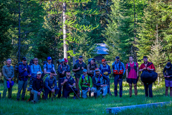
Group photo (missing one, possibly)

I drove down to Holland Lake and took this right before the start
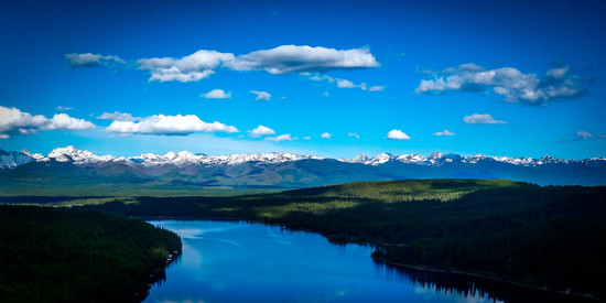
Holland Lake and the Mission Mountains from the east
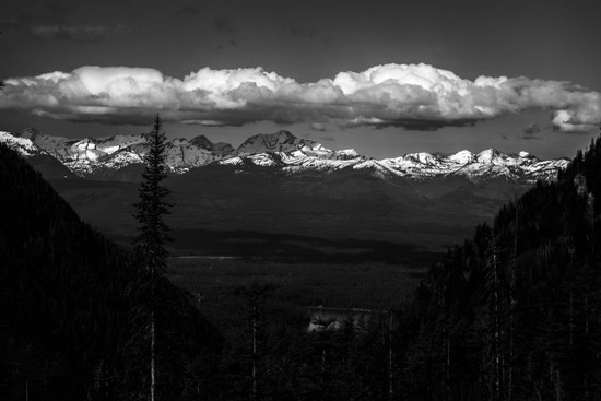
Mission Mountains to the west in B&W
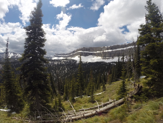
Upper Holland Lake from Pendant Pass

Looking up at Pendant Pass

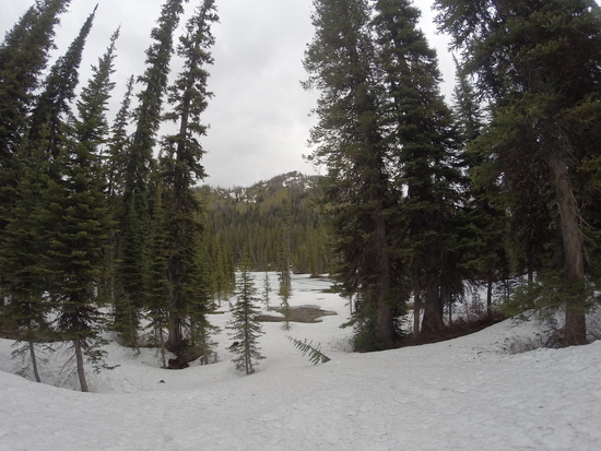
A little snow in Pendant Pass

Big Salmon Falls

Looking east across Big Salmon Lake
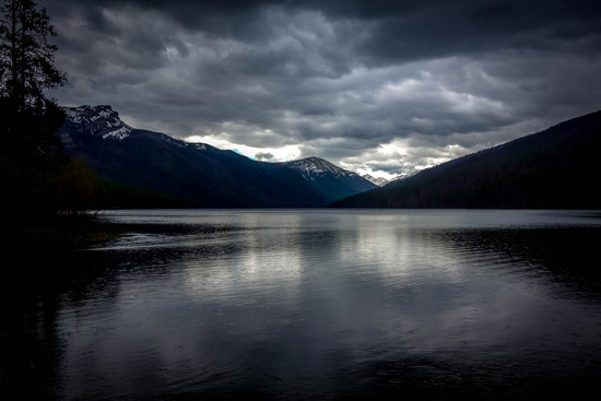
Big Salmon Lake as it began to rain for the second time

The South Fork of the Flathead
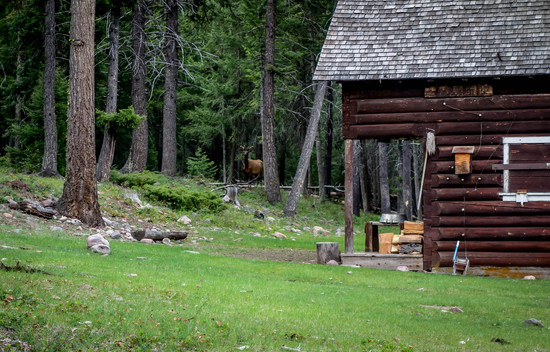
An elk by the Black Bear Ranger Station
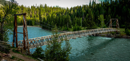
The Black Bear Pack Bridge
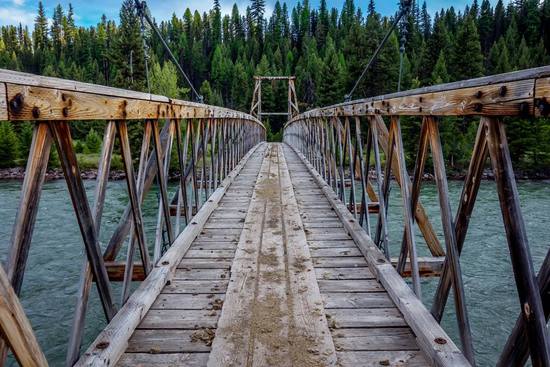
The Black Bear Pack Bridge
Awesome Derek. Your photos are in another league. Thanks for sharing.
Dan, I downloaded a free-trial of Adobe Lightroom and played around with it over the weekend for the first time. Seems to do the trick. Now you know why you and Tanner would pull-away as we headed to Upper Holland. The pace had nothing to do with it (not).
I am in BMWO-envy to those of you who made it to Swift Reservoir and love reading all of the trip reports. If only I had stuffed my pack with an Alpacka Ghost and used it to get across the Spotted Bear River, and later on the Middle Fork. Lessons learned, I suppose. I did learn that I could walk 70 miles'ish without sleeping and only a few short breaks along the way to eat a snack and refill my water bottle.
In any event, I'm looking forward to what Dave has in store for next year. I wouldn't mind heading back to The Bob to get that off my chest though. If on my own, then that's ok, too.
Derek
I am enjoying reading through all of the trip reports.
John – Nicely done. That is an excellent loop that not many people attempt this time of year. I thought it was interesting that you saw a pack train in there. Maybe the only non-BMWO people seen this year? That's not counting the runner coming down the Owl Creek trail Saturday morning that had to be wondering what was going on.
Derek – loved the pictures. Very vivid colors. I never get sick of that view from the Swans over to the Missions. I'm sorry your trip hit a roadblock and am not surprised the river was impassable considering what I saw up higher. It's nice you were able to visit Glacier.
Dave – Good write-up. I hadn't realized that we camped within a few miles of each other that first night. I am happy you were able to float some of SF Birch Creek. The weekend prior to the event, the SF looked like it was low enough that a raft could be scraping bottom frequently but was a little higher Memorial Day. I'm not sure what the future holds for me and the BMWO, but it would be sad to see it leave the Bob. Although, I understand the temptation, it will be difficult to find a comparable place. The size, navigable rivers, and variety of route opportunities is going to be difficult to find elsewhere. I like the idea of something through the SE part of the Bob. Maybe a checkpoint on the summit of Scapegoat Mountain ;)
Looking forward to seeing Dan's and everyone else's accounts. It would be cool to get an idea of everyone's route and plot it on a map similar to what Sam did with the historical start/end points. We covered a lot of the wilderness this year!
… I did learn that I could walk 70 miles'ish without sleeping and only a few short breaks along the way to eat a snack and refill my water bottle.
That right there is some powerful stuff, folks. And I agree with prior commentators, beautiful pictures!
Alright I finally finished writing this great trip up:
Wow, Dan! Great report.
I feel a little sheepish feeling tired after one of my sub 10 mile days after observing your >50 mile day.
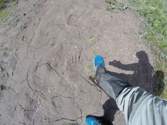
Great photo of four different critter tracks in one mud photo. I've seen bear plus wolf tracks very close to each other but not a four-bagger.
Tanner and everyone:
I also have greatly enjoyed reading all the trip reports and love the pictures. Thanks to everyone for all the effort. Morgan and Justin are enjoying a few extra days in the Flathead Valley and won't be home for two more days. I am looking forward to their trip report. Morgan said he took something like 400 photos.
Seeing the pack train was a big surprise. They must have taken a long route to avoid going through snow-covered passes. We (Morgan, Justin, Alex, Chase) first saw the horses on the second afternoon at the Big Prairie pack bridge. I was about 100 feet west of the bridge when I saw the train approaching so I moved off trail to let them pass. It was amusing to watch the horses' skittish behavior as they approached the bridge. The lead horse refused to cross the bridge and turned to the right. The wrangler did not fight the horses' inclinations and merely circled around for another try. The second effort worked.
Someone (Morgan?) mentioned that the ranger station at Big Prairie was already occupied so I am guessing that the train was supplying the station??
We also saw the trail runner on the first day and talked to him for a minute. I got the impression that he was a local who frequented the trail, but I'm not sure. I briefly explained to him who the 17 of us were and what we were doing. He smiled and seemed to admire our efforts.
Well… as everyone already knows, Alex and I were the second to last group out and the last to get to Swift. Alex's ankle swelled up bad after day 2 to White River Park (27 miles). We were able to wrap and elevate it over night, making it manageable the next day but we had to turn our daily milage down considerably; adding a sixth day to our itinerary. We treated his overuse injury with plenty of Vitamin "I" and tight wraps, while we cranked out 20 mile days back to back. It paid off. At 5:45pm on Thursday, Alex and I arrived at Swift Dam TH soaked to bone by a heavy, arctic freezing rain system from the North. Every creek was now a raging, muddy, brown waist-high torrent. Even linked-up arm & arm, we were almost swept away by half a dozen of them. Alex entered stage-1 Hypothermia 2.2 miles from the car, after crossing Haywood creek but I reacted fast had him a hot drink, started a small "WetFire", and had him drinking olive oil straight out of bottle for caloric warmth. He's doing fine. I stayed warm and avoided losing heat by putting my trekking poles away and wrapping myself up in my cuben shelter as soon as I felt my rain jacket soak through (mile 5). I walked as a cuben burrito for 17 miles and fortunately, avoided hypo. Hopefully Morgan and Justin managed to stay dry (yeah right) and warm during that arctic system, it was a nasty one. Would have much rather had snow…
I knew the Bob Marshall Wilderness Complex was "wild", but I didn't know it would be THAT wild. What a beautiful place. To be walking out there for 6 days though, gave me an entirely new respect for the power of mother nature. From here forth, I'll tell stories to Pacific Northwesters about the Bob Marshall's unrivaled beauty and grandeur landscapes. A truly wild place with pristine meadows full of White Tail deer. Where elk stir about the dense forests and young black bears wander above and around snow line. Don't worry though, Dave, my tales of waist deep river fords, constant ominous thunder clouds, ankle deep muddy trails, miles of snowy passes, raging rivers, and frequent grizzly signs is sure to keep the PacNW crowds far far away ;)
Total Miles: 128.6
Total Trail Days: 6
Total Bear Sightings: 1 (Black; top of Larch. Proximity: 100')
Total Miles Stalked by a Grouse: 1.5
A Few Images from the GoPro: (HD BMWO Video Coming Soon)


Wonderful report Dan- congrats on such speedy finish! I've contemplated a raft simply for tougher fords, but then I know would be tempted to take advantage of the flows and probably kill myself, but it's certainly fun reading others accounts- definitely appears to be well worth it's weight.
Chase- glad you guys made it out safely (although that last bit definitely sounded worrisome!) and were able to thoroughly soak up the Bob, it truly is a wild place. A 100+ mile jaunt cements any doubt about it's wildness :)
Congrats on finishing what only a handful of folks have done!
Become a member to post in the forums.
advertisementYour privacy is protected: We do not transmit your user data to third-party ad platforms or advertisers, and we do not host third-party tracking pixels. Backpacking Light serves ads on its own custom, native, and internal platform.
 Titanium Pot GrabberUltralight titanium pot grabber weighing just 4.5 grams.