Can anyone give some advice on the best transportation methods? It sounds like morgan and I are going to be hiking together. The most obvious way would be to leave two rental cars at the start and end point but hopefully there is a better way.
Topic
2015 Bob Marshall Wilderness Open
Become a member to post in the forums.
- This topic has 343 replies, 28 voices, and was last updated 10 years, 5 months ago by
 .
.
There's probably going to be several people dropping cars off at the end and shuttling back to the start somehow. So hopefully you guys could just rent one car, drive it the end and get a lift to the start somehow. Or if you really want a challenge you could pedal back to the start, stash the bikes and retrieve them post-Open. I expect in another month or so plans will start to be formed for shuttling logistics.
The biggest hurdle in deciding to participate in the BMWO, for me, was coming up with a solid transportation plan. I finally decided to fly a friend who was willing to drop me off at the start and could track my progress (Spot Gen3) to be there for me at the end whenever, or possibly wherever, that might be. The distance dropping a car at the end and having to retrieve another car from the start afterwards seemed impractical.
Transport for the Bob is definitely a pain. I look forward to this in large part because it's one of the handful of times each year I impose upon folks (my wife) for rides to be able to do a proper traverse.
We'll do what needs to be done to make sure everyone gets where they need to go. A better discussion to have closer to the start date.
I should also mention that cell service is marginal at both THs. If you don't have Verizon you'll probably get nothing.
I plan on renting a car, shuttling it to the end and (hopefully) hitching a ride with someone back to the start. As of right now I don't think my brother is coming but we'll see.
I'm hoping to get out of the woods with a day of free time before I head back to the airport. Perhaps I could drive back at a pre-arranged time to see if anyone is waiting at the TH.
I'm been thinking about getting a Delorma Inreach at some point. Maybe we could be creative with that. I could theoretically text my progress and the progress of anyone I meet on the trail to contacts.
Like Dave said this discussion will make more sense as it gets closer but those are some ideas I'll toss out to anyone who's interested.
A few weeks ago I was pondering the idea of finding or creating a "Bob" map with all the trails shown in 8 1/2 X 11 inch format. Was this a reasonable idea, would the map be too crowded or unreadable? Could I leave the Cairn Carto maps in my pack most of the time?
After some more searching today I found this map: http://www.bmwf.org/pdfs/bmwcfirehistmap.pdf (image below).
Other than the distracting colors indicating the areas covered by recent fires it seems to be just what I was looking for. Of course there is no topographic information and no place names. All you get is trail numbers and water courses. For detailed info the Cairn Carto maps or similar would need to be consulted. I could see carrying this map in my pocket and being used for *most* navigational purposes. Of course prior homework is advisable, too.

A somewhat similar small map of the Flathead Forest portion of the Bob can be created by following these steps:
Download Google Earth if you don't already have it installed.
Go to the Flathead National Forest Geospatial site here: http://tinyurl.com/Flathead-Forest-Geospatial
Scroll down to Trails Routes under Transportation.
Click on the .kmz file and Google Earth will open with the trails nicely displayed in blue on a satellite image. The file actually loads as a .kml (not "z") file; I attribute this to computer weirdness or a typo and just ignore it. You will get something that looks like this:
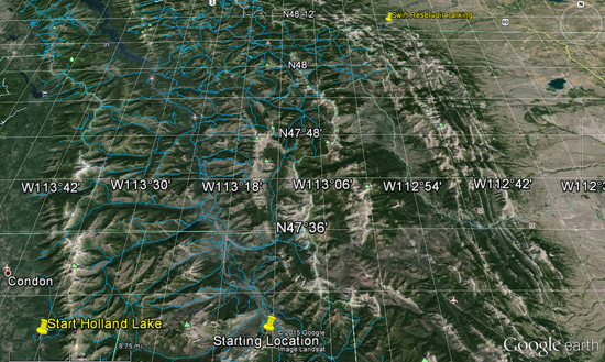
Adjust the zoom and play with all the features to your heart's content. I added the start and finish points in the map above. It appears that you would have to print two 8 1/2 X 11 sheets in landscape mode to make the trails legible.
Unfortunately I do not see a corresponding Lewis and Clark Forest Geospatial map to display via Google Earth. A considerable number of trails in the eastern portion of the Bob are thus not available as far as I can tell.
Wish I could get the lat/lon to print; my printer ignores that info. Maybe you need the Pro version of G.E. to accomplish that?
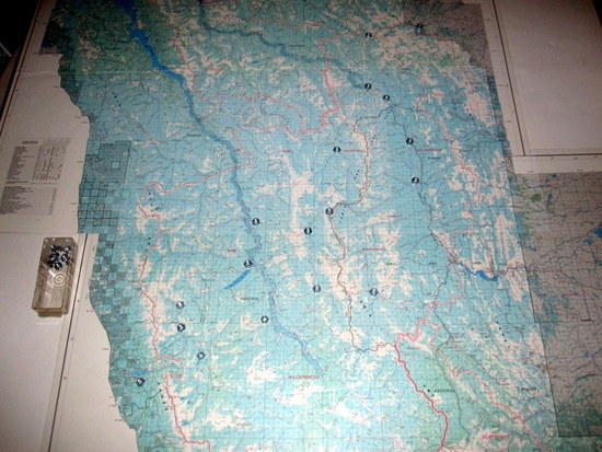
One more item of map fun. I just happen to have the Forest Service map mounted onto a flat surface. No creases, bumps to contend with. Here I am using machine nuts to mark and play with intersections, points of interest for planning purposes. Don't read anything into the points I have marked–they are very preliminary (as if you could discern much, anyway). Poor photo, sorry.
very nice :) I was contemplating taking the Cairn maps to a printer and have them play around and see if I couldn't get a somewhat more compact map
So, what are the chances I'll be able to hike DAW-PIT after the BMWO this year?
Looks like the weather in Glacier has been balmy. While I know things can change, what are the impacts on the BMWO if they don't? Too early to waste any energy hypothesizing?
Could this possibly cause bugs to be more of an issue?
http://www.abcfoxmontana.com/story/28276015/warm-winter-impacting-glacier-national-park
Dave,
We'd like to say "Thanks" for taking the time out of your busy schedule to host this event again, and all of the thought and planning that goes into such a commitment.
Two of us will be attending for sure, arriving at the Holland Lake TH Friday from here in Portland, Oregon. We've been reading the threads for about 2 months now and have already worked out the shuttle logistics. After a month of weekly meetings including hours of Carto map studying and Google Earth flyovers we've finally worked out our primary (ideal) route. If I know me though, that route's probably going to change 2 more times. Then again at the trailhead…aaand probably again at the Flathead. ha. Looking forward to hearing more from you and the participants as we near May.
~Chase and Alex
I've been thinking about what clothing I would bring on this trip.
worn:
nylon button up shirt
golite running tights
shoes: TBD but something minimalist
wool blend socks
inov8 debris gaiters
hat
sunglasses
carried:
black diamond alpine start (windshirt) – 7 ounces
arcteryx alpha fl (rain jacket) – 11 ounces
cap 4 hoody – 8 ounces
montbell Mirage (puffy) – 12.5 ounces
fleece gloves
rocky goretex socks
2 pairs of thicker, tall wool socks (one that I can change into my goretex socks with if I hit snow and one to change into at night)
if there is a good chance of near freezing rain leading into sub freezing snow then I will probably want to carry more than my cap 4 hoody for active use. I do fine walking quickly uphill but on the downhills or going slow on tricky terrain, I get dangerously cold fast.
For sheltering and sleeping:
mountain hardware phantom 15 – 2 pounds
neoair xtherm – 15 oz
flat 8×10 sil nylon tarp – 15 oz
Based on pictures it looks like the area is heavily forested. i prefer a flat tarp for forests. i can set up a lean-to and build a fire to cook and warm up/dry out. and since i don't use trekking poles i dont have to carry a separate pole, just pitch off trees.
I get cold easily so I decided on the 15 degree bag. I know it will keep me warm reliably below freezing. I could use my summerlite with my mirage or the phantom without the mirage, but I want to play it safe.
^ looks pretty good-nothing wrong w/ playing it safe! :)
I'm going back forth between a down vest (Ex-light) and jacket (Ghost Whisperer). My upper base layer is going to be a Ibex Indie, if it gets really hot (unlikely) I'll go shirtless :)
A 100 wt fleece pullover and bottoms- sleep and as mid-layers if it's really cold.
My Alpine Start will probably be windshirt as well
I've got a pair of lighter Schoeller pants (MH Chockstone) that I had "cropped" (the gal took the extra material and made cargo pockets)
tall wool socks w/ gaiters and a spare pair for sleep
I'm going to bring neoprene socks w/ a thin wool liner if it gets really soggy (very possible imo)
my PI Trail N2's for shoes probably studded
raingear- I'm going to pick up a pair of rain chaps and either my Helium II- light at 6.8 oz or my RAB 3l eVENT jacket, not as light at 12.9 oz; and MLD rain mitts
wool beanie and wool gloves
I was going to bring my Neoair (and still might), but I'm leaning towards a short section of a z-lite w/ a 1/8" ccf pad. I've only had one puncture in my Neoair and it was repairable, but I'm thinking about playing it real safe
I'll use my Katabatic Palisade quilt- I've found it underrated at 30 degrees
shelter I plan on my eVENT bivy w/ a small (5×5-ish) tarp for coverage over my head- spartan, but effective
I look forward to meeting you both, Chase and Alex. Everyone can plan on meeting for dinner/beers at the Hungry Bear Friday night. It's 3 miles north of the turnoff to Holland Lake, on the west side of the highway.
Mike's chart of recent fires is a very handy resource. Everyone you should take a close look at it. Snow melts faster in burns, but you also have to deal with the extra deadfall.
Chances of doing Dawson-Pitamaken without crampons is pretty slim. There's a decent chance of the high traverse itself being clear as it faces west and is open, but there's a northwest facing section towards the north end which is very steep and exposed, and at 7000'.
Good chance of being able to hike some other stuff in Glacier, however.
As of know mid-elevation snow (where almost all the snotel sites are) is showing as average. This is because the snow-water equivalent is average. Snow depth is generally below average, which tells us that the snow is very dense from the sunny last two months. This means that it will melt quite a bit slower than usual.
So slow melting snow means compacted dense snow right? I've gone back and forth but I'm pretty sure I'll be using a pair of snowshoes, its just a matter of which pair. If snow is compact I'll lean towards lighter and shorter.
Seems like a strong turn out is forming. Fun stuff!
Justin: I'm hesitant about the Mirage because it's likely too warm to wear while moving, and it's probably unneeded at night as your Phantom 15 should be plenty warm. The Mirage is ideal for long breaks or hanging around camp, but you may not be planning on much of that. You know your body and game plan best though.
I've always overpacked insulation for the BMWO (Synth jacket + Ex-light Vest in 2012, 100wt fleece + Ex-Light 2013), but I'm pretty much always either on the move or in my sleeping quilt. Unless the forecast is abnormal, I doubt I'll take more than a 100wt fleece this year (in addition to my 20F quilt). The little devil in my head is saying to bring no insulation and just jump in my quilt if I get cold.
Although we won't be participating in the event, my wife, our baby, and I have booked a couple nights stay at the Holland Lake Campground and are planning to attend the start of the event to cheer everyone on.
Sam- hope I get to meet you and your family, we live in the same state, but haven't crossed paths yet (nor w/ Dave C either)
Mike
Well as of right now my brother is officially out, too busy. I'll do it solo but I open to joining forces with others. My plan is to leave a car at the end on Friday, hitch a ride back somehow and hopefully be done in 3.5-4 days. I have to fly out on Thursday. If I get out a day early I could drive back to the TH to see if anyone needs a ride.
Luke- my tentative partner is about 90% committed, but your more than welcome to join us or me as the case may be- we'll (me) be solely on foot (no rafts)
we're also hoping for 3-4 day finish :)
Mike
Thanks for the invite Mike, we'll see. Over the winter a stubborn pulled muscle just wouldn't heal right so my training schedule was wrecked. We'll see how I am in May. Absent an injury I probably COULD do the course right now in 3-4 days. But I'd probably hurt something and be useless for half the summer. I longer packrafting/hiking adventures planned for June so I don't want to wreck myself.
At any rate I'm trying not to commit myself in a way that would leave other people in an awkward spot if I bailed or went slower then expected (so I'll be careful about committing to shared rides for example until I feel more confident in how I'll perform)
Mike it would be nice to make your acquaintance. We can swap hunting stories!
I've planned routes for myself for each and every year the BMWC has been run and even started in on a training regimen a couple times – but family and friend camping trips have always won out. It's a very cool event and I'm really happy that Dave continues to make it happen. Look forward to shaking his hand.
Sam,
So, since you're not doing thr BMWO this year, what would your prefered route be from Holland Lake to Swift Reservoir? Just wondering. It's fair-game to ask a non-participant, right?
Note: If it's freezing rain at the Holland Lake Campground, I'll let your family huddle around the wood stove in the Owl Creek Cabin if you can provide useful information.
Derek
Derek, I have only spent 30 minutes considering this year's route and as with year's past I have put together three routes.
1. staying on trails
2. mostly trail but some off trail
3. a combo of trails, off, and packraft
4 Last year I also figured out a mountain bike route too but given the start/finish not being conducive I didn't do that this year. A fatbike is going to participate in this thing someday.
This year the packrafters seem to be favored (although just because a route shows a downhill creek section in Google Earth doesn't necessarily mean that creek section goes (easily) in a packraft. There are some pretty big stretches downhill water that will give the participant some time off their feet so a raft seems a good idea for those looking to get this thing done quick.
A route that sticks mostly to less-snowy valley bottoms and generally staying on trails can be put together for around 85 miles. With good conditions this could go in 2.5 to 3 days which would be a very solid effort across the Bob.
That's all I'm saying since planning for this is half the fun. As for a warm place to sleep, my family and I will be cozying up in our new-to-us pop-up camper!
Derek, I sent you a PM on various thoughts.
Greg- feel free to pm as well :)
Mike
Become a member to post in the forums.
advertisementYour privacy is protected: We do not transmit your user data to third-party ad platforms or advertisers, and we do not host third-party tracking pixels. Backpacking Light serves ads on its own custom, native, and internal platform.
 Air-Permeable Fleece HoodieLightweight fleece hoodie weighing just 5.2 ounces.