I recently went to the Lost Coast and did the Northern portion of the of the Lost Coast trail. I paid to get shuttled from Shelter Cove, where I parked my car, to the mouth of the Mattole river.(This was well worth the money)The phone number for the shuttle is 707-986-9909.Very nice lady.
So I went solo but one hour into the hike I met two awesome people who I hiked the rest of the way with. They just happened to be from Santa Cruz, where I am from.
What a small world. We hit it off and had quite a little adventure. Marriah's dad lives in Shelter Cove.
The first night we stayed at Randle creek. What a nice place to sleep.
The next day we hiked to Big Flat, a famous surf spot. This was the most beautiful day of the hike with fields of wild flowers and whales in the Ocean. We had perfect weather and perfect tides with negative tides at midday.
When we got to Big Flat there were all these cool drift wood shelters. Check out this cool one with my new gatewood cape and serenity bug net.
The next morning we headed out a little after high tide started heading out and followed some fresh bear tracks for awhile. This section of the hike was all beach hiking. The soft sand is hard to walk in and therefor any trails on the hills near the beach were utilized to there fullest potential. This was now our third day of hiking and we got back to shelter cove about 2:00pm. We got burgers and beer at a local deli by the landing strip. This is where we met one of Marriah's friends.
Just another random experience common to this trip. Marriah's friend, Misha, wanted a ride to the top of the cliff where he was going to paraglide back to the landing strip. I got to tell you that it was pretty cool watching this dude jump off the cliff.
That night we drove to the southern section of the lost coast trail, the Sinkyone wilderness and camped at Jones beach camp. A heard of Roosevelt elk checked us out but it was night and none of my photos came out. The southern section is much more lush and since I only hiked a little around a can't say much about this portion of the lost coast trail.
What an awesome trip. Thanks for reading.
Josh
Topic
Lost Coast King Range
Become a member to post in the forums.
- This topic is empty.
Great trip! Thanks for sharing Josh!
That one's definitely on my to-do list- now even more so!
Doug
Josh,
Nice to see hiking photos that are different from the typical sort of hike we see. Great to see that part of the country.
Are you missing a photo with your Gatewood Cape, or maybe I misunderstood?
Yes it seems that photo was missed. Lets try again.
Josh
I really like six moon designs products.
Josh,
Another great photo. The Gatewood Cape really seems to provide a tight pitch. What bug net is that?
The bug net is called the serenity bug tent. Six moon designs make it and it is compatible with the gatewood cape. You can also set it up by itself for stargazing. It has a bathtub floor and elastic straps that hook to the gatewood stakes. I really like both items and highly recommend them.
Josh
nice report josh.
glad the trip went so well.
we'll have to go and do the southern section – sinkyone.
heres a few shots i took in '04.


Cool trip, thanks for sharing your pictures and trip details. I did not know there was a shuttle, and it was also cool to see photos to know what the northern part of the trail would be like when putting together my gear.
I did the sinkyone section two weeks ago, and the trail was clear and easy to navigate. Some downed trees, but only one was challenging to get over. Very lush with frequent and robust water supplies.
Last weekend I did the kings range section. Trails were in decent shape for early season. Water supplies were about 1.5 miles apart, and running strong. The springs at elevation were running well too. Cooskie Cr trail was clear southeast of cooskie creek. I missed the trail connection at the beach, but rather enjoyed wading upstream to find the trail. Spanish ridge was overgrown, but I was able to run down the hill at 9.8MPH cross country sans trail. Rattlesnake ridge was littered with downed trees near the beach, but BLM says they have cleared that since I filed my trail report. Bucks creek and Kings Crest were in good condition for early spring. Kings Peak road is not passable via passenger car at this time, but is clear through to Saddle MTN road.
There was a mountain lion hanging out near the tree line at big flat in the kings range section of the trail, please be aware that there may be a large cat stalking a very popular campground full of kids, pets, and people.
Some pictures: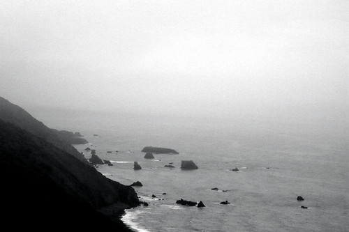
the far southern end at Usal Beach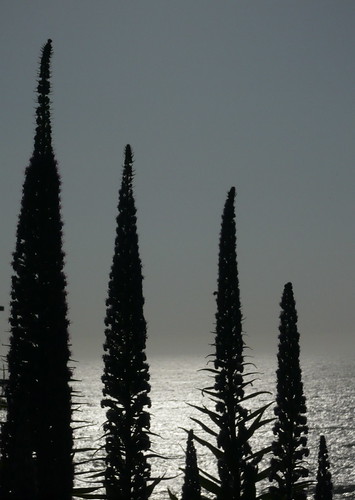
flowers along the coast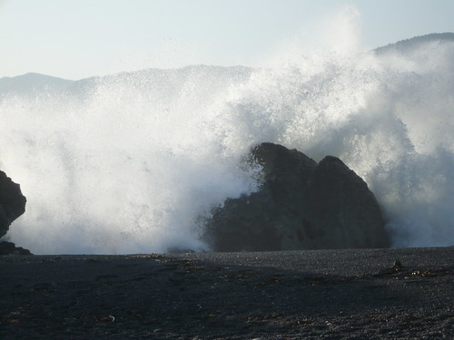
the tide comes in
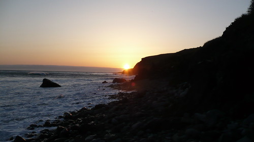
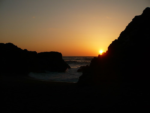
sunset walking back to big flat after getting squeezed off the trail at high tide
sunset at black sand beach
I would like to go inland from the coast someday. It looks pretty steep. That was a nice thing about hiking along the beach and zero elevation gain, although the soft sand is pretty tough. Did you see the lion or just hear it. Were you solo? Big flat was nice but I really liked Spanish Flat. I like the pictures of the tide coming to get you.Thanks for your post.
Josh
Hey Josh, Jay wilkerson here! Funny I was there not two weeks before you. My wife and son had great time. We camped at the same site your tarp-tent was at. Are you planning for the 110 miles? Let me know!! It's looking like a great July!!!!!! Has your wife gave birth yet? Do you still have the Hall Pass??? Let me know?
Yes it is definitely still on for 110 miles of northbound PCT bliss. Looking forward to it. Talk to you soon.
Josh
The first time I did the Lost Coast, King Range section, in 1992 I saw a lion on the beach between Shipman Creek and Buck Creek. It was nosing around the tide pools at low tide.
I'll be doing Mattole to Shelter Cove, solo, starting June 2. Hope all I have to deal with are bears at Big Flat. Last year I did the Coast twice. Once in June and again in September. No bears in camp but I did see a pod of about 6 whales.

Whale on the Lost Coast

Bear Tracks on the Lost Coast
I always use Sherrie Luallin's shuttle service: 707-986-7437 or cell: 707-223-1547.
Has anybody taken their dog on the trail? Our dogs are in good hiking shape but a few websites make me worry. How did your dogs fare? Booties suggested?
If your dog's feet are trail-toughened, and used to hiking for several days in a row, you shouldn't have to worry. Most of the trail is dry so water softened paws should not be a problem. Check the dog's pads often to be sure.
I would definitely say take booties along for the beach sections. On the terraces you won't have any problem. The beach tears my dogs paws up. We go walking off pavement everyday so their pads are quite tough. Had a cut pad last time we went. Was a hard trip for him the last few miles. Easily avoided.
Become a member to post in the forums.
advertisement
Small Business Sales Week

Discover deals from 90+ small outdoor brands during Garage Grown Gear’s Small Business Sales Week.
