If you have a route from Bean to Cedar that is under 100 miles, you’re doing pretty well – ours is closer to 110 :)
Definitely bring a GPS (or phone software), you’ll most likely use at least a couple of times.
Topic
Become a member to post in the forums.
If you have a route from Bean to Cedar that is under 100 miles, you’re doing pretty well – ours is closer to 110 :)
Definitely bring a GPS (or phone software), you’ll most likely use at least a couple of times.
So it looks like my friends are going to bail, so I thought I’d see what the vibe around buddying up with strangers is! My route is in the mid 90’s; planning to do it in three 30 mile days and be home on Monday in Missoula night. Anybody else aiming for a similar schedule?
Tyler,
I have a 3-day plan, and have most-likely plotted a similar route. I don’t snore, have good navigational skills, and am not afraid of walking in the dark. I’m taking a packraft, even if I might not use it much. Let’s discuss.
Derek
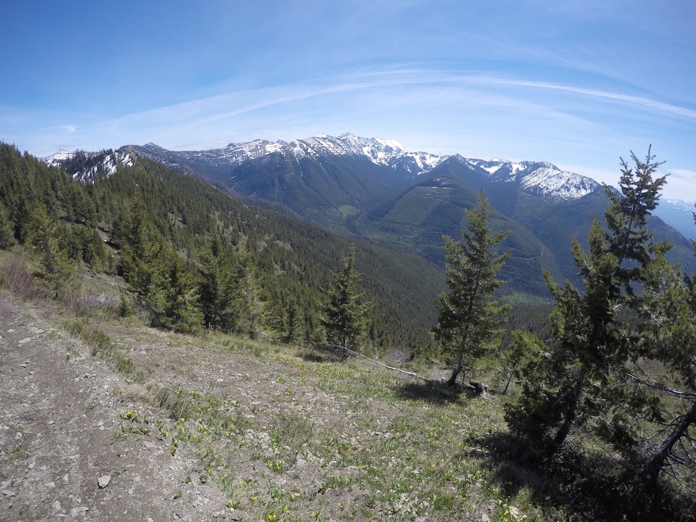
This was yesterday, looking SW from halfway between Napa and Inspiration Points. Was able to drive a 2WD hatchback to within a mile of the Napa Point TH.
very interesting; our last big training session was in the Elkhorns yesterday and we ended up on snowshoes for the majority of the loop- I was really surprised at the amount of snow (not complaining, was glad to see it- just surprised)

I am super jealous of you folks in Montana. My training the last two weekends has consisted of many hours on the road bike since all of the local trail systems are closed due to rain.
I am also looking for a ride to the start from Cedar Creek if anybody has room for one more. Alternatively, I will be flying into Missoula on Thursday. If any of the Missoula crew has extra space to the start let me know.
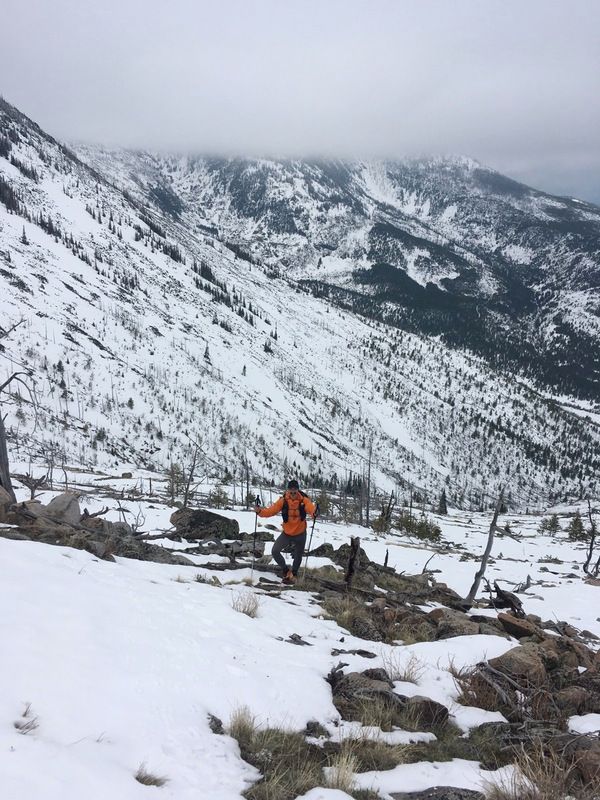
I too went for an overnight scouting/training mission this weekend. Left from the Benchmark trailhead and took the S.F. Sun River trail (203) ~20 miles up to the base of the Chinese Wall. The last ~4 miles of my walk was quite snowy. Patchy snow began ~6000 ft. on north aspects and became increasingly consistent on the trail until ~7000 ft. where it was full coverage and at least a few feet deep. The snow was undoubtedly deeper where I was than elsewhere, on a northeast aspect beneath the Wall. I expect there will still be snow on most aspects >7000 ft. in two weeks.
I was in trail runners and didn’t really posthole too bad, I think you would describe the snowpack as isothermic corn, but it did slow me down considerably and take toll on ankles and calves. The trails lower down were a bit muddy, but totally manageable.
Otherwise conditions were excellent. Cloudy mornings in the 40s, clearing a bit by afternoon to maybe high 50s, dropping to something like low 30s at night. No other traffic, grizzly tracks but no trouble, elk down grazing. Creeks and springs are all running, which meant I didn’t need to carry much water. High creeks also meant some wet crossings, but nothing dangerous.
I am wishing I had 4 days to do the Open, though, because my body is sore today!
Dave,
During your hike near Inspiration Pass were you able to see any of the damage from the Bear Creek fire?
Hi everyone! My name is Jason. There are a group of three of us coming up from the Tetons to join the BMWO. We are looking for a ride from the finish to the start. Anybody have room for 3? Thanks! Looking forward to this!
Derek, the Bear Creek fire didn’t burn on the Swan side of the divide. I skied up Bunker to Inspiration Pass back in March, and all of the main fork of Bunker burned in that fire. Quite impressive to see.
Jason, glad you folks are coming, will be good to see you again.
Looks like several people are still trying to figure out shuttle logistics. I am just going to plan on renting a car to leave at the start. I am happy to help run shuttle from cedar creek to the start on Friday. Derek has first dibs on riding shotgun, but I should have room for 2 or 3 more. If more people express the need for a ride by the end of the week, I can look into renting a bigger car. I would prefer not to have to hitchhike all the way back around at the end, so if somebody would volunteer to get me back to my car afterwards, that would be great. If not, so be it. I plan to finish sometime Monday afternoon or Tuesday at the latest.
Regarding the Bear Creek fire, I assume there wasn’t too much deadfall on the road when you skied it Dave. Did you get much of a glimpse into the Gorge creek drainage?
Shotgun! I’ll take you back unless you find another ride and I don’t get too lost in the woods. Cyrus looks like a good second option at this point, if he hasn’t made other plans.
Seth, Do you have room for us Teton folks in the back seat?:). (Fred, ABbY, and I). We could also could possibly take you back to the start as we might finish around the same time. If so, what time would you leave on Friday?
Yes, will be good to see you Dave. It’s been since Grizzlyman!
I am on a 4 day plan with no interest in more than 25 walking miles in any day other than the last. As I am planning to spot my RV at the finish I probably won’t head back to pick up my Razor till Wednesday late morning. If that works for anyone.
I tried calling the Montana DNRC Swan Lake office today to inquire about Cedar Creek Campground usage, but was greeted buy the sound of a fax machine. I tied another number, but a woman answered the phone and promptly hung up before I got a chance to ask any questions (she didn’t sound very official, so I think that must have been a wrong number).
The Visit Montana website states that a Montana state recreation use license is required. Does this mean a sticker on a vehicle?
http://www.visitmt.com/listings/general/recreation-area-campground/cedar-creek-campground.html
Also, the season for the park opens on June 1st.
Would this effect us parking there prior to June 1st if this information is accurate?
You can camp anywhere on Montana DNRC land.
As long as its not longer than 16 days.
There is no season, you can camp there throughout the year.
They probably mean the “popular” season.
The “Recreation Use License” accompanies any hunting and/or fishing license. Technically its required to camp on state land but it is not enforced.
The Montana State Lands Recreational Use License is a slip of paper that you can carry in your wallet. There is no vehicle sticker associated with the license. The license can be purchased as a stand-alone permit not connected with hunting or fishing licenses. +1 in hearing from reliable sources that enforcement is nonexistent (as of about 5 years ago, anyway). I have seen new signs posted at some trail heads in the last one or two years, however, indicating that licenses are required.
Well it looks like I’m out this year. With the mild spring and overlap with other Bob trips I’ve done (and will do this June) I can’t justify the travel time/cost.
I’m keen to return in the future. Fingers crossed Dave re-does the 2014 route sometime. If we get tough weather and everyone bails out I’m be kicking myself for not going.
Hopefully Tanner and others can post their Delorme links here. I’m keen to follow online.
Noooooooooooooooooooo! Best of luck on your other adventures, Dan. You’re an inspiration to us all.
Seth, Just checking in about a ride possibility for 3 of us from the finish. Thanks! Anybody been keeping track of number of people coming out to adventure?
Jason
I will have room for the Teton crew. I’d prefer to meet up sometime Friday morning. PM me and we can discuss the details.
I will be driving out with my girlfriend on Thursday/Friday from MN. I’m planning 3 days of hiking, no packrafting.
Is snow shaping up to be similar to 2013 levels? I’m looking at White Pass and wondering if it would be firm enough without snowshoes in the early morning before deteriorating in the sun.
I’m also looking for some hiking/backpacking suggestions for 3-4 days. In the Bob, Glacier, or elsewhere. I’m tempted to hike into the Kintla Lake backcountry campground for a scenic basecamp and heading up towards Boulder Pass as a day hike. Or a similar route in a different location in Glacier NP.
We’ll have room for some passengers at the finish, but I’m not sure where we’re headed at the end yet…likely north towards Kalispell, but until we decide what to do for the rest of the week, I can’t commit to giving anyone a ride.
For those who haven’t been, Cedar Creek is a small and very humble campground. Not very formal at all.
Adrian, lots of options in Glacier. Kintla out and back to Boulder Pass would be fun, though the skeeters down by the lakes might be fierce. Going into the Belly River and venturing up to Mokowanis Lake and Stoney Indian Pass is another great out and back. As of this past weekend the rangers told me the bridge over the Belly wasn’t in. though it probably will be after Memorial Day. We can talk in person a week from now. Depends on how sick you are of snow and mud slogging after the Bob.
Badger Pass, May 19, 2013: 57″ (on May 25th, start of BMWO, 52″) Despite those measurements, “Durston and Gedney found little more than a mile of snow at the (White River) pass.”
Badger Pass, May 19, 2016: 18″ (May 28th, 2016 ???) The current forecast looks wet for the next several days, but am not sure if that translates to snow in the passes.
I am planning to drive down from Canada on Friday and would prefer to leave my truck at Cedar Creek and catch a ride to Bean Lake.
Does anyone have space for me? I will obviously help pay for gas.
Thanks.
-Troy
Become a member to post in the forums.
 New Ultralight GearSee the latest releases in ultralight cottage-brand gear from small makers.
 Loading...