Learn How to Use the inReach
Update: Garmin inReach Mini 2 Review
We are currently testing the Garmin inReach Mini 2 and comparing its performance to the original model. Results will be published at this URL in the form of an updated review shortly after Garmin releases the inReach Mini 2 on February 1, 2022.
Browse our curated recommendations in the Backpacking Light Gear Shop – a product research & discovery tool where you can find Member gear reviews, Gear Swap (used gear) listings, and more info about specific products recommended by our staff and members.
Gear Shop » Garmin inReach Mini 2
Introduction
The Garmin inReach Mini currently represents a “gold standard” for lightweight satellite messaging devices.
The category of satellite messaging devices includes products that are capable of the following core features:
- The ability to trigger an SOS signal to an emergency search-and-rescue network.
- The ability to send location/tracking/SMS messages to friends, family, or colleagues.
In addition, some of these devices are capable of two-way messaging (the ability to also receive messages from friends, family, colleagues, or search-and-rescue personnel).
The Garmin inReach Mini falls into this latter category – it’s a two-way satellite communications device and, at only 3.4 oz, represents one of the lightest available devices in this category. Arguably, the Garmin inReach Mini is probably the most feature-rich and powerful product when compared to all satellite communications devices that weigh less than 5 oz.
Review Rating: Highly Recommended + Guide’s Gear
The Garmin inReach Mini is the smallest, lightest, and most powerful satellite messaging device on the market.


As a standalone device, it offers GPS navigation, two-way messaging, location sharing, and weather forecast retrieval. Paired with a mobile device and the Earthmate app, the Garmin inReach Mini is a highly capable and easy-to-use mapping GPS with a much faster interface for managing and composing messages. The Garmin inReach Mini is tiny in size, light in weight (3.4 oz), durable, waterproof (IPX7), and features a very high-quality build.
In addition to receiving the Backpacking Light Highly Recommended Rating (info here), the Garmin inReach Mini is also recognized with our Guide’s Gear label (info here).
 Where to Buy
 Where to Buy
The Garmin inReach Mini is not yet widely available at specialty retailers. REI online currently maintains the largest inventory.
- Buy the inReach Mini at REI.com and help support Backpacking Light (see Disclosure below)
Features & Specifications
Features
- SOS (ability to trigger an interactive emergency SOS response coordinated with 24/7 search-and-rescue monitoring services via the GEOS network, with response confirmation and status messaging)
- SMS (ability to send and receive text messages via SMS-capable telephone numbers and email addresses using integrated virtual keyboard or pairing to a mobile app)
- inReach-to-inReach communications (ability to communicate directly to other inReach users via SMS, including location sharing)
- Location sharing (ability to share location and tracking points with friends/family via the web-based MapShare portal)
- Weather forecasts (ability to request point weather forecasts for current locations and planned destinations)
- Smartphone integration (ability to integrate with Apple/Android Garmin EarthMate mobile app for easier messaging and access to additional features, such as mapping, aerial imagery, and NOAA charts)
- Wearable/handheld device integration (ability to send and receive messages via other Garmin-enabled devices, including some wearables and handhelds)
Specifications
Network specifications
- Satellite network: Iridium
- Coverage area: 100% global
General specifications
- Physical dimensions: 2.04 in x 3.90 in x 1.03 in (5.17 x 9.90 x 2.61 cm)
- Weight: 3.4 oz (97 g) (verified by author)
- Impact resistance rating: MIL-STD-810F
- Ingress rating: IEC 60529 IPX7 (can be used in rain/snow, can be immersed in water up to 3 ft (1 m) depth for up to 30 minutes
Working temperature ranges
- Operating: -4 deg F to 140 deg F (-20 deg C to 60 deg C)
- Battery charging: 32 deg F to 113 deg F (0 deg C to 45 deg C)
Battery
- Type: lithium-ion (internal) rechargeable
- Replaceable? Sort of (see review below for details)
- Capacity: 1250 mAh
- Manufacturer-claimed battery life: Up to 50 hours at 10-minute tracking with 2-minute logging (default); up to 30 hours at 10-minute tracking with 1-second logging; up to 20 days at the 30-minute interval power save mode; and up to 1 year when powered off
Display
- Type: sunlight-readable, monochrome, transflective memory-in-pixel (MIP)
- Size: 0.9 in x 0.9 in (23 x 23 mm)
- Resolution: 128 px x 128 px
Interface(s)
- USB (micro)
- Bluetooth (wireless)
Maps and memory
- Point location capacity: 500 (waypoints, favorites, locations)
- Route capacity: 20
- Preloaded maps: None
- Ability to add/view maps? No
Aviation-specific software and service integrations
- Garmin Pilot App (Android)
- Lockheed Martin Flight Services (LMFS)
- Adverse Condition Alerting Service (ACAS)
- Surveillance-Enhanced Search and Rescue (SE-SAR)
- Enhanced Special Reporting Services (eSRS).
Other software and service integrations
- Garmin EarthMate mobile App (free – Apple/Android)
- Garmin Explore Web App (free – unlimited cloud storage for trip planning and device management)
- Garmin inReach Sync App (free – Windows/Mac application used for syncing device data directly to a computer)
- Garmin inReach Service Plans (additional cost – required for SOS, live tracking, messaging, and data syncing)
Review Context
I’ve been carrying a satellite communications device of one type or another since 2004 when ACR Electronics released the consumer-targeted Terrafix 406 personal locator beacon. Considering the 12-ounce weight and $640 price tag of that device, it’s safe to say that satellite communications devices have come a long way since then.
Since then, I’ve field-tested each of the following messaging devices on more than 100 multi-day backcountry trips:
- SPOT Messenger (Gen 1, Gen 2, and Gen 3)
- SPOT X
- DeLorme/Garmin inReach SE/SE+ and Explorer+
- GSat Micro
- Iridium NAL SHOUT Nano
In addition, I own and carry an Iridium 9575 Extreme satellite phone, which is my device-of-choice for trips where I’m guiding clients. It’s also what Backpacking Light issues to its guides for our Wilderness Adventures treks. The ability to communicate by voice directly with medical professionals for in-the-field consultation has proven to be an invaluable asset for guided trips.
Finally, I’ve rented and carried the Inmarsat iSatHub Terminal for satellite broadband use several times for photo and long-form live blogging from the backcountry.
Of these devices, the GSat Micro and Iridium NAL SHOUT Nano are best integrated with commercial OEM applications. The iSatHub Terminal is a highly-specialized (and heavy) broadband device that offers capabilities significantly beyond the needs of most recreational backcountry users. Likewise, these devices won’t be considered further in this review in the context of evaluating the market position and performance of the Garmin inReach Mini.
In addition to the devices listed above, a new consumer category of satellite devices is emerging. This category – satellite “hotspots” – is perhaps best represented by the not-yet-released Somewear Labs Global Hotspot, which (unlike devices from Spot and Garmin) requires a smartphone for messaging. The Somewear Hotspot reflects the continuing trend in this category towards miniaturization and smartphone integration. SPOT released a similar device called the Connect in 2011 but met with terrific resistance among users due to its inability to pair with seemed like half the phones on the planet. The SPOT Connect has been discontinued.
Worth noting: Iridium has nearly completed the deployment and installation of its new broadband satellite network, Iridium NEXT/Certus. This should dramatically decrease the cost of satellite broadband services, increase its availability and access to the consumer, and spur innovation in developing the next generation of satellite communications devices.
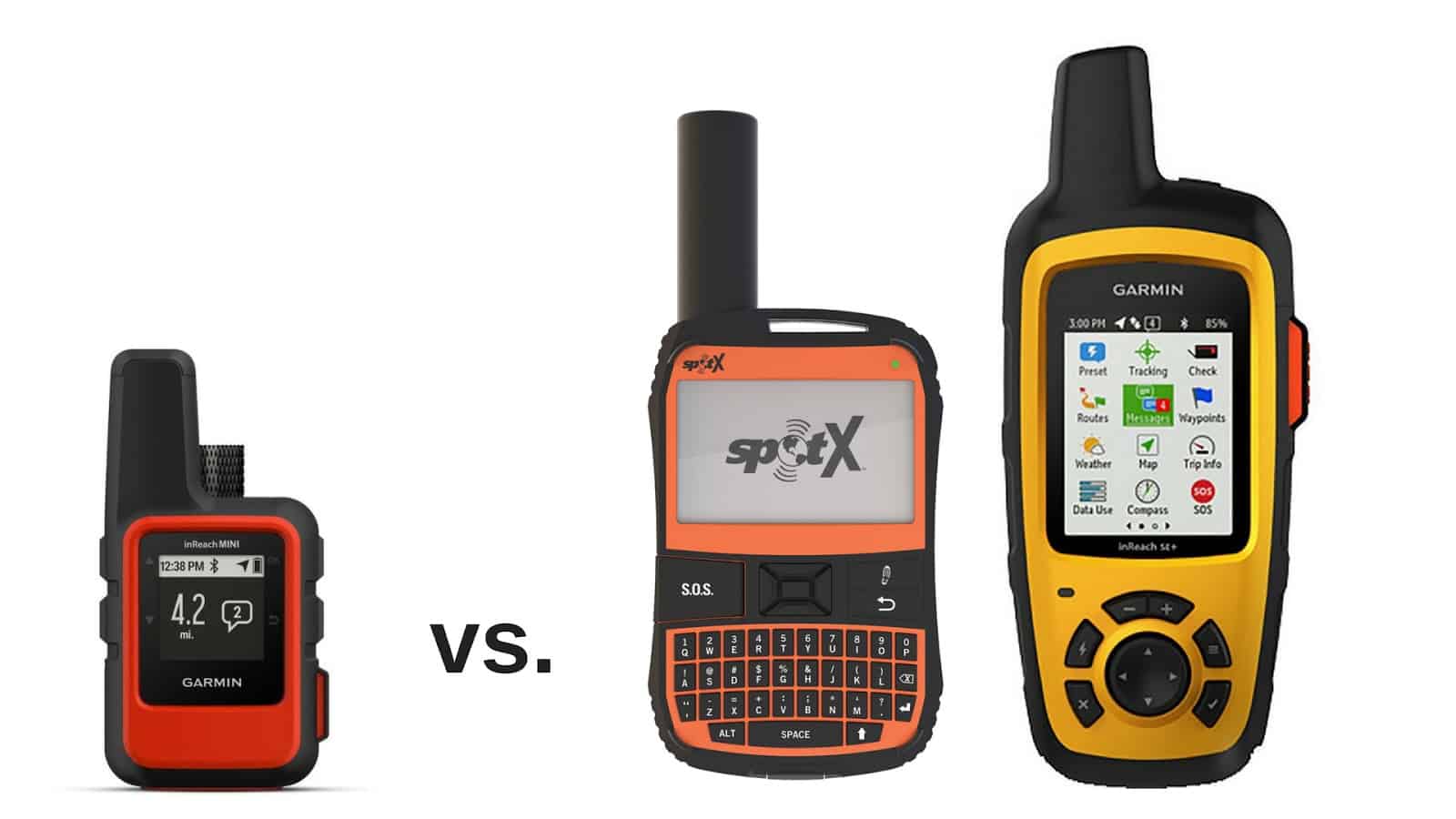
The following table compares the key overall features of the most popular messaging devices available now from SPOT and Garmin, and soon from Somewear.
| Device | Weight | MSRP | GPS Navigation | Messaging | Keyboard Type | Smartphone Integration | Weather Forecasting | Visual Map Display |
| SPOT Gen3 | 4 oz | $150 | no | 1-way, canned only | none | none | no | no |
| SPOT X | 7 oz | $250 | yes | 2-way | Integrated (physical) | none | no | no |
| Garmin Inreach SE+ | 7.5 oz | $400 | yes | 2-way | Integrated (virtual) | Yes, optional | yes | yes |
| Garmin inReach Explorer+ (*) | 7.5 oz | $450 | yes | 2-way | Integrated (virtual) | Yes, optional | yes | yes |
| Somewear Global Hotspot | 3.0 oz | $320 | No, requires mobile app | 2-way | none | Yes, required | yes | no |
| Garmin inReach Mini | 3.5 oz | $350 | yes | 2-way | Integrated (virtual) | Yes, optional | yes | no |
(*) The Garmin inReach Explorer+ includes features tyipcally found in high-end mapping GPS units, including a pre-loaded base topo map set, a pressure altimeter, and compass.
From this table, you can readily identify the unique benefit of the Garmin inReach Mini: It’s the lightest 2-way messenger that doesn’t require (but notably, allows for the use of) a smartphone to enhance usability and features (e.g., a visual map display).
Setting up the Garmin inReach Mini
To show how the Garmin inReach Mini works and highlight some of its core features, I’ll walk through the exact process I used for setting it up, preparing it for first-time use, using its various functions on a hike, and evaluating post-trip data.
Unboxing
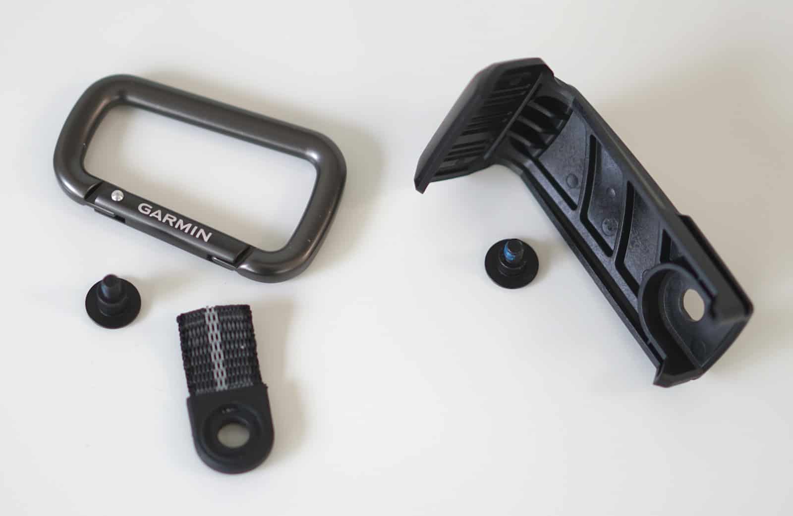
In the box:
- inReach Mini device (97 g / 3.4 oz verified on my digital scale)
- Micro USB cable (3 ft)
- Carabiner harness adapter (4 g)
- Spine mount adapter (13 g, includes screw)
- Carabiner (13 g)
- Allen wrench for adapter screws
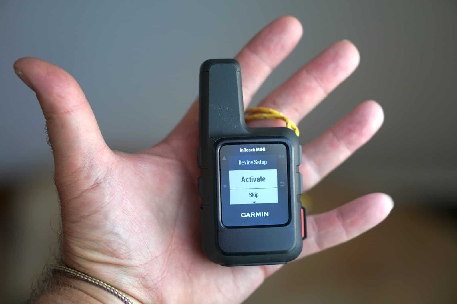
My very first impressions upon holding the Garmin inReach Mini:
- It seems very well-built and durable and has the feel of an expensive device that exudes high manufacturing quality.
- It’s really small – much smaller than I thought it would feel (see photo below; for context, I wear size Small gloves).
Hardware Interface

The Garmin inReach Mini has six buttons (A-E) and one interface (F):
- Power on/off (recessed to prevent accidental push)
- Up/Down (2 buttons; used to toggle between menu items)
- OK (used to select a menu item)
- Return (used to go back to a previous menu)
- SOS (protected by a snap cover to prevent accidental push)
- Micro-USB interface (protected by a snap cover to prevent dust/moisture ingress)
Attachment Adapters
The Garmin inReach Mini ships with two adapters for attaching the device:
- A carabiner harness adapter, which consists of a screw, a 3/4″ loop of 5/8″ nylon webbing, and a carabiner. The total weight of these three items is 17 g. Instead of using this adapter, you could also tether the unit to your pack using a thin piece of cord affixed to a strap anchor on the device.
- A spine mount adapter, which can be used to attach the Garmin inReach Mini to a variety of device mounts sold by Garmin (e.g., suction cup mounts for car windshields, Molle strap mounts for backpacks, and bicycle handlebar mounts).
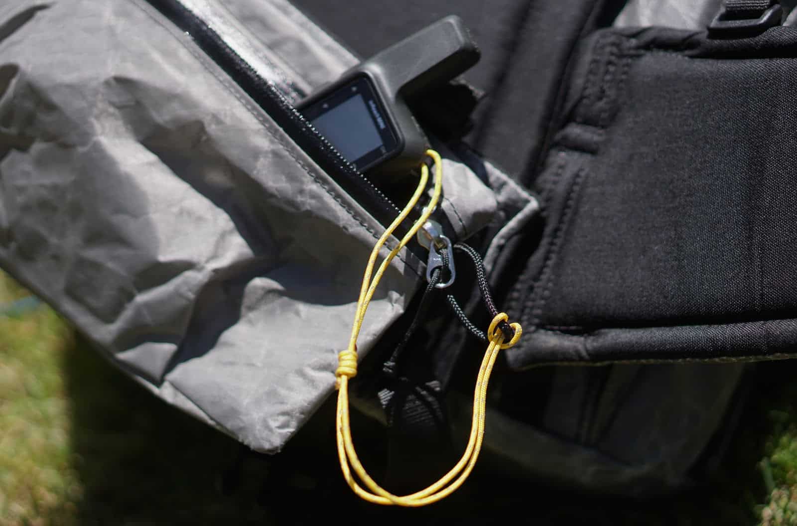
I expect to stow my Mini in a backpack pocket (either my top lid or hip belt pockets), and don’t see the utility of using either type of mount. However, I could see the benefit of attaching a cord tether for packrafting or backpacking so I don’t accidentally leave the device somewhere. For backpacking, I made a 10-inch long tether loop using 1mm Dyneema core cordage for girth hitching the unit to a loop on my pack, belt loop, packraft grab loop, etc. It weighs 1 g.
Charging the Device
When I unpacked the Garmin inReach Mini from its box, it was about half-charged. A 3-foot micro-USB charging cable is included. The USB port is on the left side of the unit, protected beneath a rubberized cap.
After draining the unit’s battery, I was able to fully charge it (using wall power) in 118 minutes.
Powering Up
When you first power up the device, you are taken to the Device Setup menu, which gives you the option to either Activate or Skip.
Upon selecting Activate, you are instructed to visit inreach.garmin.com to activate the device.
However, before activating your Garmin inReach Mini, you need to decide what you want to do with the device, so you can wisely select the plan that has the best value for your needs.
Shopping for an inReach Service Plan
Garmin inReach devices require a service subscription through the Garmin inReach Global Satellite Technology service plan to use live tracking, messaging, syncing, and SOS features.
- Plan details are described here.
- To signup for a plan, you must have your inReach device in hand; then you can signup here.
Decision #1: Personal or Professional Plan?
Professional plans include tools that allow for the centralized administration of several devices. Based on Garmin’s subscription marketing copy on their website, it’s implied that advanced API access for developing custom inReach applications is only available with professional plans. I’ve heard conflicting reports about this, and couldn’t confirm directly with Garmin before this review’s publication time. If API access is important to you, then you may have to consider a professional plan.
Otherwise, the overwhelming majority of recreational end users should select a personal plan.
Decision #2: What Plan Level?
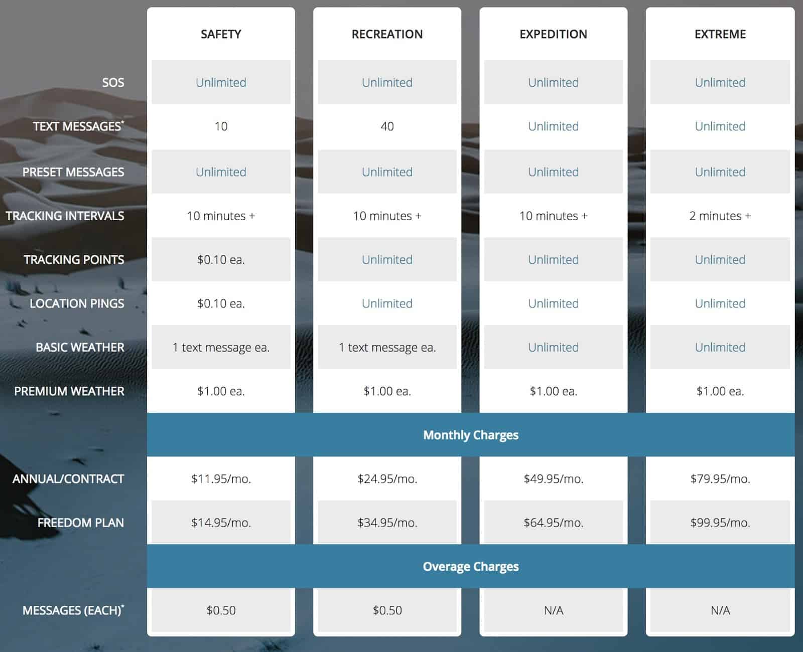
Four plan levels are available:
- Safety – The minimum plan suitable for users who only want to use the inReach for “just-in-case” emergencies. It includes an unlimited number of SOS messages and preset SMS sending, and ten custom text messages per month. Surcharges are otherwise levied for location pings, tracking points, and message overages. One basic weather request per month is included, but premium (more detailed) weather requests come with a surcharge.
- Recreation – The plan that will appeal to most recreation users, because it offers unlimited tracking and location pings, and 40 custom text messages per month.
- Expedition – The power user plan, offering unlimited text messages, tracking points, location pings, and basic weather requests. The only surcharges are for premium weather requests.
Extreme – Same as Expedition, but tracking intervals are decreased from the standard interval of 10 minutes to 2 minutes. The Extreme Plan may be of interest to pilots and cartographers.
Decision #3: Freedom Contract or Annual Contract Plan?
Garmin offers both annual contracts and month-to-month service plans (called “Freedom” plans). Here’s how they compare:
| Plan Type | Activation Fee | Minimum Term | Upgrade Fee | Downgrade Fee | Billing Frequency |
| Annual | $19.95, one time | 1 year | none | $24.95 | monthly |
| Freedom | $24.95, annually | 30 days | none | none | monthly |
In addition to the prices above, users are also subject to the federal Universal Service Fund fee and any applicable state and local taxes.
In addition, non-U.S. customers are subject to applicable VAT.
The following table outlines the inReach service plan pricing structure as of June 2018:
My Choice
For my own needs, I knew that I didn’t need a professional plan, as I don’t manage a device fleet.
In addition, I wanted the ability to post relatively frequent updates to both social media channels as well as to communicate with my family and company staff. And although I still appreciate the ability to use a satellite phone for medical emergencies, the ability to save more than half a pound, and rely on the inReach Mini alone, is awfully tempting. Regardless, It wouldn’t be hard for me to exchange several dozen text messages during a multi-day trip. Weather updates would be interesting to have as an option, but not a critical requirement for me in most situations. The one exception to this would be if I wanted to camp in an exposed location above the treeline. In that case, I’d certainly like to know if thunderstorm activity was in the forecast!
So the question I had to answer was this: how many text messages would I have to send to make the Expedition plan more economical than the Recreation plan?
For an annual contract, the difference between the Expedition and Recreation plans is $25/month. Since that Recreation Plan offers 40 text messages without overages and charges $0.50 for each message thereafter, the additional cost of the Expedition plan is only worth it if I’m sending a monthly volume of 90 or more messages.
Here’s how it all works out:
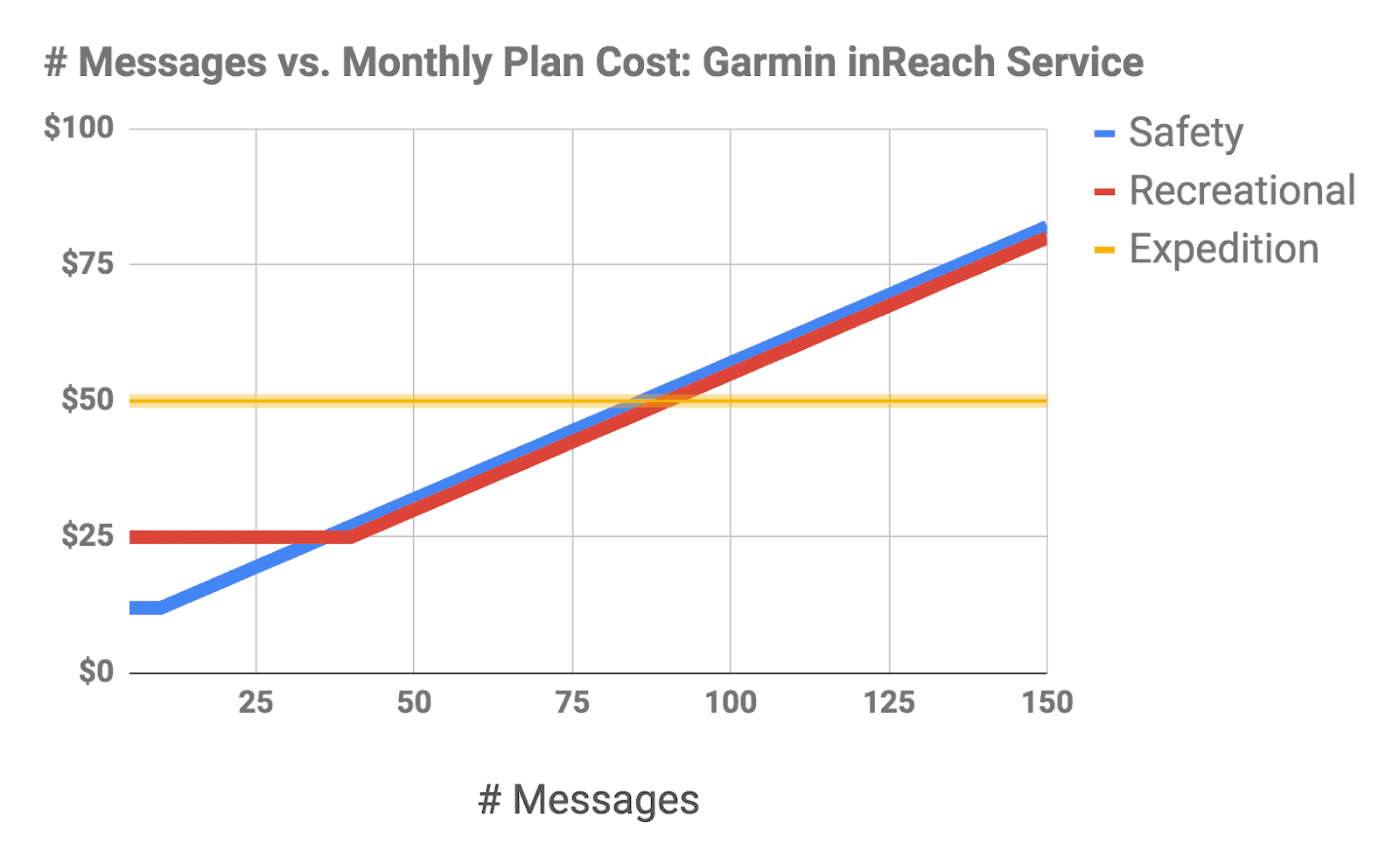
Takeaways:
- If you’re sending and receiving less than 40 messages per month, the Safety Plan offers the best value.
- If you’re sending and receiving between 40 and 90 messages per month, the Safety and Recreational plans offer similar value.
- If you are sending more than 90 messages per month, the Expedition Plan offers the best value.
Interestingly, if all you are concerned about is messaging, there are no advantages to purchasing the Recreational Plan. The only real benefits it offers over the Safety Plan are unlimited location pings and tracking.
In other words, the Safety Plan offers the best value if you need only messaging capabilities, and the Recreational Plan provides the best value if you also need tracking capabilities.
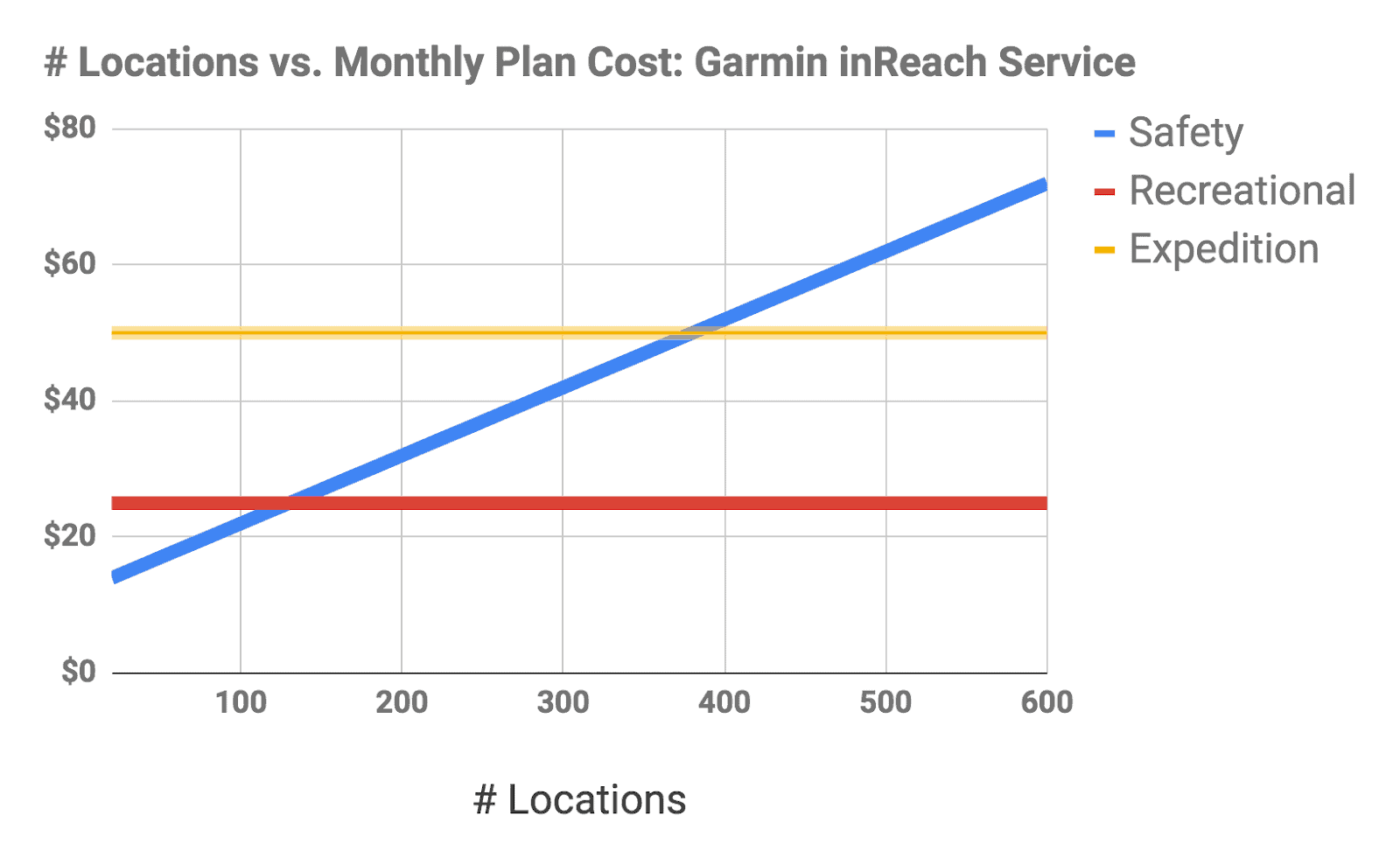
The next graph reinforces this conclusion:
Takeaways:
- If you need less than 120 location pings (including tracking points) per month, the Safety Plan offers the best value.
- If you need more than 120 location pings (including tracking points) per month, the Recreational or Expedition Plans offer the best value and are further dependent on your messaging needs (see previous graph).
To put this into perspective, if you ping a location (or send a track point) once a day (for example, each night you arrive in camp), then the Safety Plan offers you up to 120 days of usage before it becomes more costly than the other two plans.
On the other hand, if you ping a location every 10 minutes, and hike about six hours a day, then the Safety Plan becomes very costly after only two days of use (after which you will have used 120 location pings).
A similar analysis can be made for a “Freedom” contract. With a difference in cost of $30/month, the only scenario that makes the Expedition plan worth the extra cost is if I’m sending a monthly volume of 100 or more messages.
I knew that I had the option of upgrading without penalty. I wanted to be able to record my route using fairly frequent tracking intervals (as frequently as once/hour, i.e., 50 to 80 points for a weeklong trek). This makes the Safety Plan a reasonable option. However, while tracking was a nice feature, I was more interested in two-way messaging capabilities (otherwise, I might consider a Spot Gen3) to stay in communications with my family and staff. Therefore, for me, the Recreational Plan was the most viable option.
When evaluating whether or not to select a Freedom or an Annual Contract, I wanted to know how many months of use per year were required to make the Annual Contract a better value. Noting that the Freedom contract requires an “annual service fee” and the Annual contract requires only a one-time initiation fee, here are the results of my analysis:

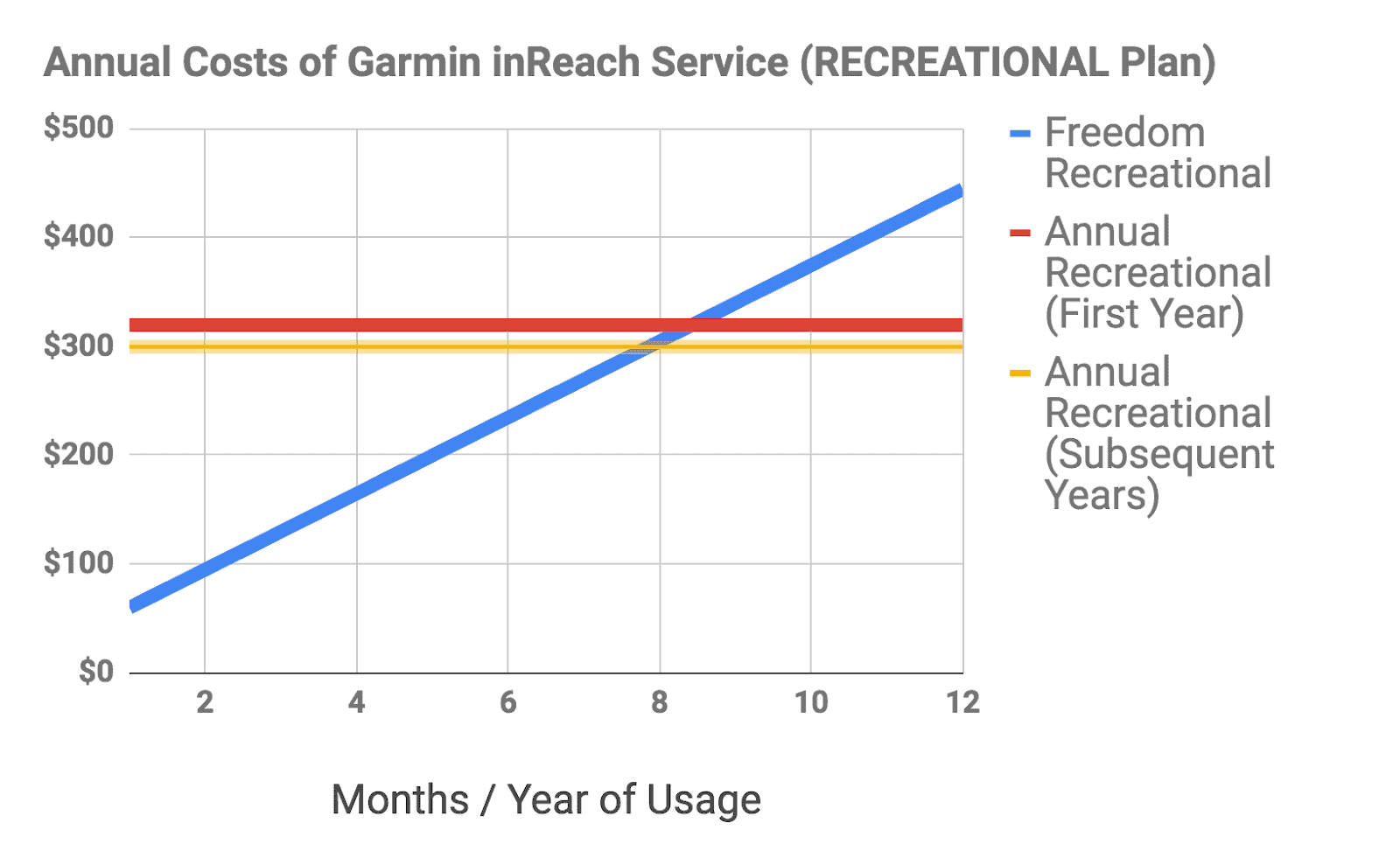
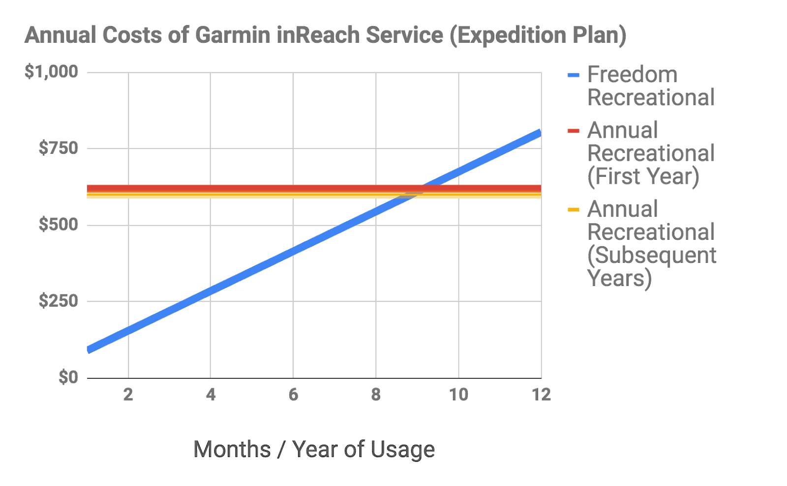
These graphs show that if you want inReach service for more than about 8-9 months of the year, then an Annual Contract may be a better value for you. However, my guess is that most users, who hike during the fair-weather summer window of June through September, will benefit from the privilege of suspending their service and opting for Freedom contracts.
As for me, I opted for the Freedom contract. As a matter of personal financial principles, I wanted to have the flexibility for month-to-month activation/deactivation as needed. As a Recreational plan subscriber, I have to acknowledge that the price of this “freedom” could be as much as $100 per year if I maintained my service for all twelve months of the year.
Signing up for Service
To sign up for service, as instructed by the device, visit inreach.garmin.com:
The process for signing up is very straightforward, and just enough instructions are provided to guide you through the process without undue duress. The process involves seven steps:
- Entering your device information (IMEI number and Authorization Code, which are provided on the device screen once you select Activate and press the OK button), email address, and account password.
- Entering your personal information (name, address, phone numbers, and any emergency medical info that would be provided to search and rescue personnel).
- Entering your emergency contact information (primary and secondary contact names, phone numbers, and email addresses).
- Selecting your contract type (Annual or Freedom) and plan type (Safety, Recreational, Expedition, or Extreme).
- Selecting your SOS Features:
- GEOS Emergency Response Coordination (included with all plans).
- Additional GEOS Search and Rescue Benefit Program (provides up to $100,000 in search and rescue resources for an additional $17.95/year).
- GEOS Worldwide Medical Evacuation (provides up to $1M for a lifesaving evac for an additional $129.95/year for US and Canada or $175/year for International coverage).
- Entering your billing information.
- Reviewing and confirming all of your information.
The entire process took me less than 10 minutes to complete. Upon confirming, an activation status window pops up:

It disappeared after about a minute, and I was returned to a screen that listed the final steps required to complete activation:
- Activation: Take the inReach outside with a clear view of the sky and press the OK button to begin the (final?) activation process. The device then acquires a GPS fix, sends an activation request, and then waits for the activation confirmation. This process took about 5 minutes to complete.
- Bluetooth Pairing: Upon pressing the OK button, the device walks you through the process of pairing with your smartphone via Bluetooth. The pairing process took about 15 seconds with my iPhone SE.
- Test Message: Upon completing Bluetooth pairing and pressing the OK button, the device notifies that you have a new message from testinreach@garmin.com. I replied to the message to confirm that everything was working OK (up to five test messages per month can be sent for free). A confirmation reply (to my reply) came in a few minutes.
The inReach Website
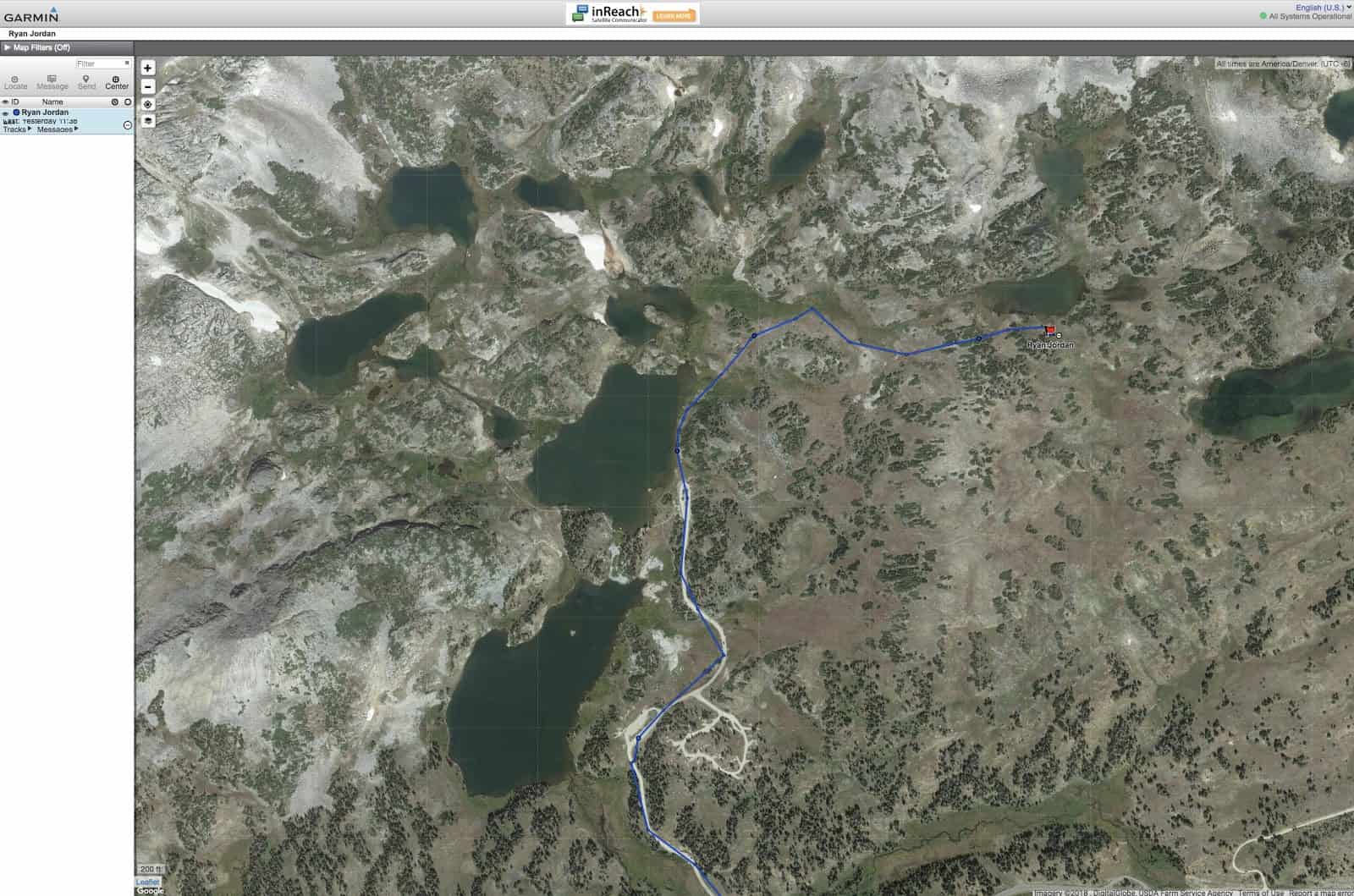
At this point, with the device working, I went to my account at inreach.garmin.com, and discovered the location of my inReach on the map:
The inReach website offers eight functions, each accessible via a tabbed menu:
Home – provides access to subscription and billing information, and some overview statistics of usage (tracking points, messages, etc.).
Map – displays an overview map (topo, road, or aerial imagery) with device location, tracks, routes, waypoints, etc.
Inbox – provides a cloud-based location for all inReach messages.
Contacts – provides the ability to enter contact info for the people you contact the most. This can be synced.
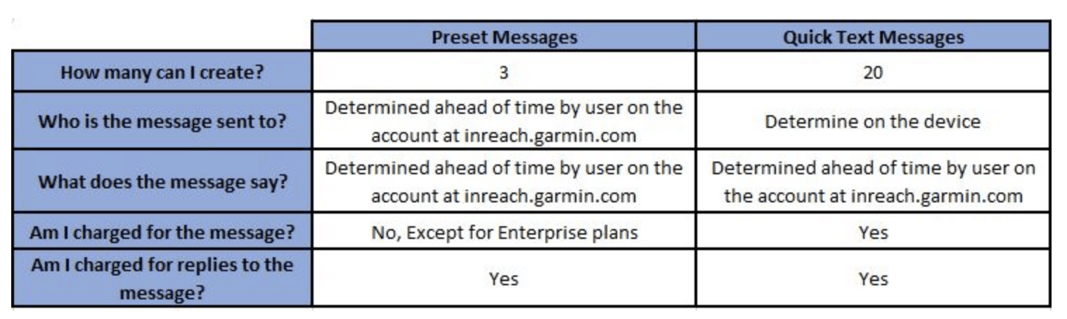
Messages – provides the ability to edit both Preset and Quick messages that are available from your device. Here’s the difference between the two:
 Social – allows you to toggle on/off public visibility of the MapShare service, where people can track your progress, or link your Facebook and Twitter accounts.
Account – provides all of the same setup info (and the ability to edit it) that you entered/selected upon signing up for a service plan.
Sync – provides instructions for syncing your inReach info (contacts, waypoints, routes, etc.) from the website to your device, and between the Earthmate mobile app and your device.
Syncing the inReach Mini
The Garmin inReach Sync application (available for Windows/Mac) is required to sync the inReach Mini to the inReach website via your computer to install available updates, as well as syncing contacts, quick text and preset messages, and other data.
The inReach can also be synced via the Earthmate mobile app.
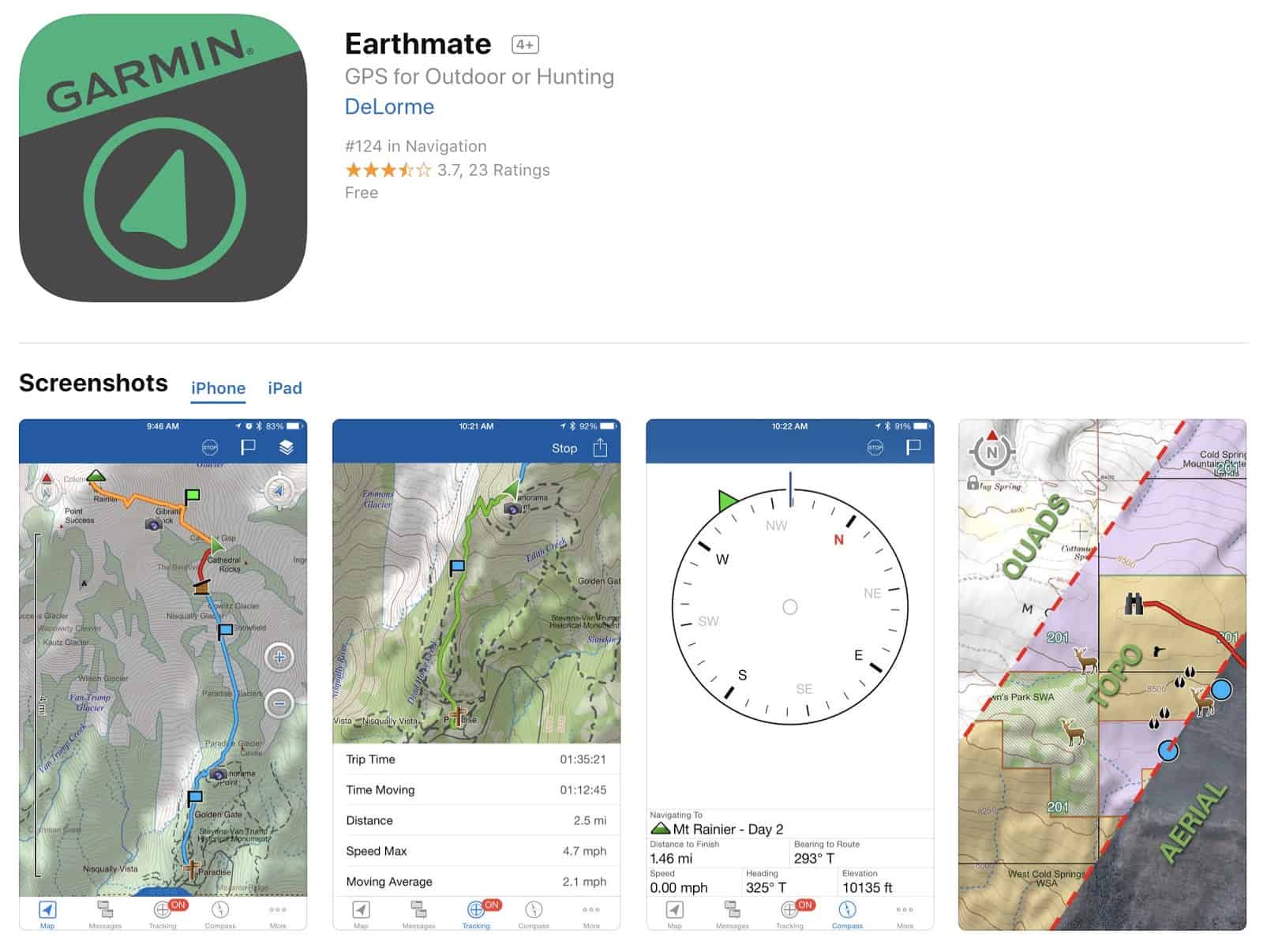
Setting Up the Garmin Earthmate Mobile App
The Garmin Earthmate app (available in both Apple and Android versions) can be used to pair the Garmin inReach Mini to your smartphone. I use an iPhone SE. The app runs smoothly, and I’ve never observed any crashes, hangups, bugs, or slow processing times using the app.
The app gets mixed reviews from users, but most reviews are very positive. As always, read app user reviews with a grain of salt. Many critical reviews are not detailed enough to provide context outside of a user’s reactive frustration.
I found the app very easy to use, with an intuitive user interface, and have no complaints about it worth mentioning here.
Before using the Earthmate app on a hike, I downloaded the Garmin Base Data and Garmin Topo North America map sets (about 250 MB of data), along with the USGS Quad Sheets and Color Aerial Imagery maps for the areas of the Medicine Bow National Forest near my home where I spent most of my hiking time. The latter two map sets for my home hiking area added another 1 GB of data.
Accordingly, I’d repeat this step (downloading local maps) before trips taken to other areas as well.
For most trail hiking, the Garmin Topo North America map set is sufficient. I like USGS Quads if I’m doing any cross-country navigation, and I like Color Aerial Imagery for identifying river hazards for packrafting trips, and potential campsite locations.
Using the Garmin inReach Mini in the Backcountry
The number of things the Garmin inReach Mini can do is pretty incredible, given its diminutive size and weight. However, at this point in the review, I think it’s important to distill what I believe are the essential core functions of the device: GPS, messaging, and weather forecast retrieval.
The Garmin inReach Mini as a GPS Device
The Garmin inReach Mini offers what I would call basic GPS functionality.
“Basic,” in the sense, that its screen doesn’t offer a high enough resolution (128 px square) for integrated mapping functionality that distinguishes basic from advanced GPS units.
As with any basic GPS unit, the Garmin inReach Mini can perform the following functions:
Location Fix, Sharing, and Waypoint Marking
After navigating to the device’s Location menu and waiting for a GPS fix, your current location’s latitude, longitude, and elevation are displayed on the screen:
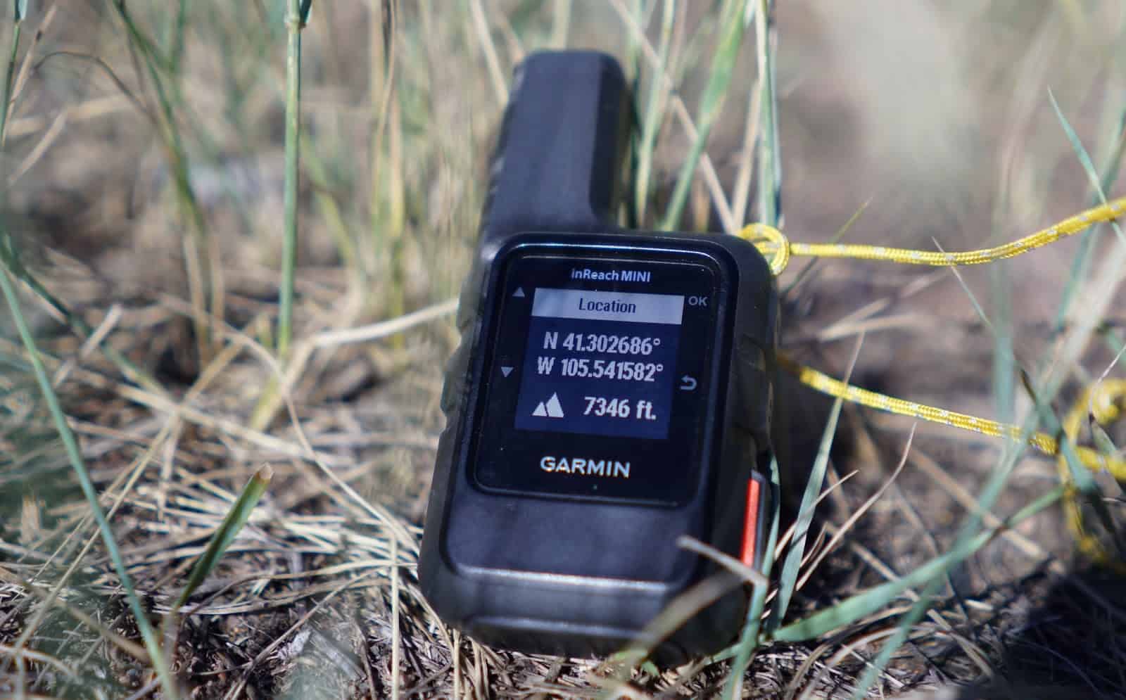
Then, upon pressing the device’s OK button, you have the option to either share the location via messaging or mark the location as a waypoint.
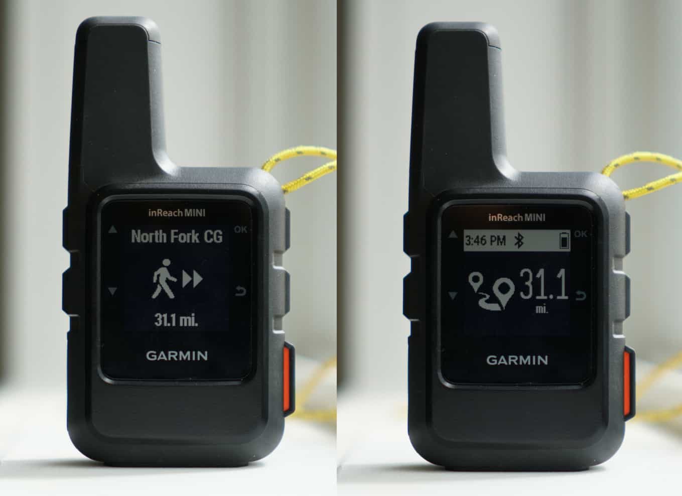
GPS Navigation
As with any GPS, the Garmin inReach Mini provides the ability to navigate towards any waypoint, or along a route. Once a waypoint is selected, and the Navigate feature is activated, you can monitor progress towards the waypoint on either the unit’s home screen or its navigation screen:
In addition, the inReach Mini provides a “compass” page that provides data about your speed and “direction”:
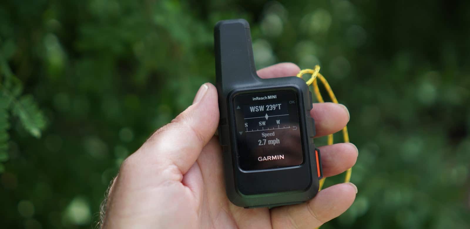
But it’s a bit misleading – the direction indicates the direction of travel and has nothing to do with device orientation, as one might expect with a magnetic compass.
Route Tracking
Finally, in addition to navigating towards waypoints and monitoring your travel speed and direction, you can record a route by tracking.
Once the tracking feature is selected, you have the option to specify both the send interval (the time interval for which tracking messages are sent to MapShare; 10 min (default), 20 min, 30 min, 1 hr, 2 hr, or 4 hr) and the log interval (the time interval for logging locations along your route for better route resolution (1 sec, 1 min, 2 min (default), 5 min, or OFF).
It’s worth noting that using a log interval of 1 sec drains the battery quite significantly; however, this might be a useful interval if creating high-resolution route tracks and more precise distances are important to you.
![]()
The Garmin inReach Mini as a Messaging Device
The GPS and tracking features discussed up to this point would make the Garmin inReach Mini a compelling choice as a standalone GPS unit. It offers GPS and tracking features similar to those found in other small and light basic GPS units such as the Garmin Foretrex 601 (3.1 oz).
However, GPS functionality alone is not what makes the Garmin inReach Mini so appealing – it’s the inReach Mini’s messaging features that make it such a powerful device. The only other devices that integrate a functional GPS as described above, with two-way messaging, are heavier (e.g., the inReach Explorer+ and inReach SE+ at 7.5 oz and the Spot X at 7.0 oz). The primary advantage of the inReach Explorer+/SE+ is an integrated color screen that can display high-resolution maps. The primary advantage of the Spot X is the integrated physical keyboard that makes typing messages easier.
That the Garmin inReach Mini, as a two-way messaging device, also includes highly functional GPS navigation features, makes it a far more valuable device than what may be the most popular device in this category, the Spot Gen3 (which weighs 4.0 oz, can only message 1-way, has no custom messaging abilities, and no integrated GPS navigation features).
Therefore, let’s explore the Garmin inReach Mini messaging functions, which include location messaging, text messaging, weather forecasting, inReach-to-inReach device messaging, and social media sharing.
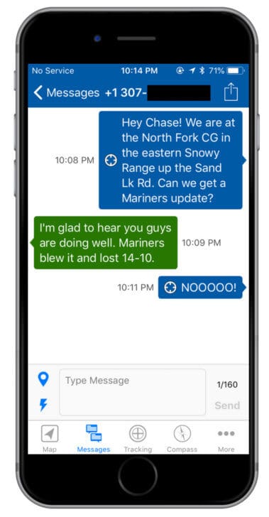
Location Messaging: Sending Locations with the Garmin inReach Mini
Location data can be sent in one of two ways:
A Location Without a Message
A location (either your current location or a preset location or “waypoint”) can be sent to any contact’s email or mobile phone number.
Included in the location data are the latitude, longitude, elevation, whether the hiker is moving or stationary, a link to the location on a map at inreach.garmin.com, and the device owner’s name.
A Message With a Location Attached
Optionally, a location can be “attached” to any outgoing text message. In this case, the location data isn’t included in the message, but a link to the location on a map at inreach.garmin.com is.
Whether a location is sent with or without a message, clicking the link reveals the location on the map and the data associated with that location:
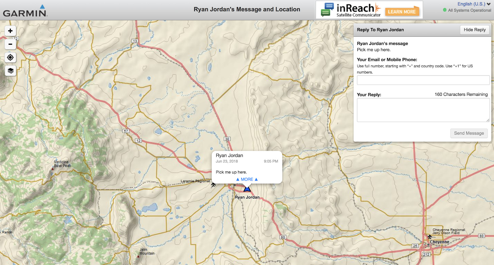
Conveniently, the recipient can use the map interface at inreach.garmin.com to view the location, the sender’s message (if any), and reply to the message directly (see reply box in upper right-hand corner). As with most online maps, the recipient can zoom in and out, and change map layers between road maps, topo maps, and aerial imagery.
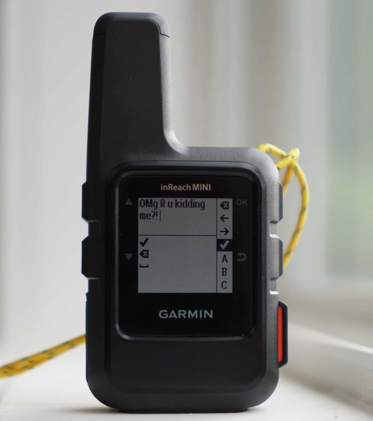
Using the Garmin inReach Mini as a Text Messaging Device
One of the Garmin inReach Mini’s most important features to me is the ability to exchange text messages with friends, family, or company staff.
The process by which text messages are sent and received on the device itself is straightforward and uncomplicated.
However, for frequent (non-emergency) messaging, my frustration level with using the device’s virtual keyboard achieved sky-high status. Can you imagine toggling through an alphabet using only up/down and select keys to craft the high literature that is a text message? Granted, there are some rudimentary autocomplete options available, along with a rather non-intuitive order of key presses for backspacing, front spacing, symbols, capitalization, and punctuation, but after spending half an hour mastering the not-a-keyboard interface, my fingers were seriously aching.
Lessons learned:
- If you are going to use the Garmin inReach Mini for emergency text messaging (other than canned preset and quick text messages), and you won’t be pairing it with the Earthmate mobile app on another device, learn how to use the virtual keyboard.
- If you are going to use the Garmin inReach Mini for frequent text messaging and are not a fan of acquiring carpal tunnel syndrome as a result of rapidly pressing the same three buttons a thousand times to compose a single message, plan on pairing your inReach Mini with a mobile device with a real virtual keyboard (e.g., iOS or Android smartphone) running the Earthmate app.
- If you don’t hike with a smartphone, but want the two-way messaging features of inReach devices, consider instead the bulkier and heavier inReach SE+ or Explorer+, both of which offer full virtual keyboards where characters can be selected with the four-direction device toggle. For a Blackberry-style physical keyboard (which provides the best typing experience of any satellite messaging device), take a look at the Spot X device.
Weather Forecasting with the Garmin inReach Mini
One of my favorite features of the inReach service is the ability to download point location weather (current conditions and forecast) to the device.
Garmin’s weather forecasts are delivered by the Dark Sky weather network, known for its terrific API and weather modeling techniques that are among the best available (not considering one recent and very funny hiccup).
I’m a bit of a weather forecasting junkie. I’ve been using Dark Sky weather forecasts nearly since they launched, and have found it (anecdotally, at least) to be more reliable at rain, thunderstorm, and wind forecasting than any other network I’ve tried (and I’ve used dozens).
A weather forecast can be downloaded to the Garmin inReach Mini for either your current location or a specified waypoint, to help you answer questions like “What will the weather be like at our Friday night campsite?”
All weather forecasts include the following data types for both current and future forecast times:
- Temperature;
- % chance, total volume (e.g., in inches) and type of precipitation (e.g, light rain, heavy rain, sleet, hail, snow);
- Humidity %;
- Wind speed and direction;
- Barometric pressure.

Two types of weather forecasts are available. They offer the same data types, differing only in the frequency and duration of the forecasts:
- Basic – for the cost of a single text message, the Basic forecast provides forecast data for a total of 2.5 days (60 hours) after the request:
- Every two hours for the first 12 hours;
- Every six hours for the next 48 hours.
- Premium – for $1.00 per request, the Premium forecast provides forecast data for a total of 5 days (120 hours) after the request:
- Every one hour for the first 12 hours;
- Every two hours for the next 12 hours;
- Every three hours for the next 12 hours;
- Every six hours for the next 36 hours;
- Every twelve hours for the next 48 hours.
The Basic forecast takes a minute or two to download once the request has been sent by the inReach Mini. The Premium forecast seems to take about three to four times as long to retrieve on average.
I can see the benefit of the long-range (more than 2.5 days) forecast provided by the Premium weather service in the following case:
- I’m still going to be in the backcountry for the next several days;
- I’m in need of a longer-range forecast if it means that a severely inclement weather forecast will result in a possible route change.
I can also see the benefit of a forecast with a higher level of frequency (e.g., a short-term forecast that is hourly instead of every two hours), but usually only in the case where I’m trying to time the crossing of a high pass during thunderstorms, or on a mountaineering trip where down-to-the-hour route decision making may be required.
Otherwise, I think most backpacking scenarios would benefit significantly from having a basic weather forecast, and only incrementally, if at all, from having a premium weather forecast.
Messaging to other inReach Devices
All Garmin inReach Devices (including the Mini) can communicate with each other through satellite messaging. This feature would be of great value for parties who split up during a trip and wish to communicate their locations, status, or meetup times and locations to each other.
Having hiked in parties that have split up (either voluntarily or involuntarily), this capability might be a significant stress-reducer! On many occasions, our split party has failed to meet up at a specified time and place. In addition, as a guide, I’ve had to split parties in order to send small subgroups out to the trailhead for assisted self-evacuations of clients, and it would have been nice to have been able to communicate with the evac crew during the evac and subsequent rejoining of our main party later in the trip.
Of course, this capability requires that each separate subgroup of a split party is carrying their own inReach device.
The process of messaging from one inReach device to another is simple: every inReach user account is assigned a unique inReach email address for inReach-to-inReach communication. If you have an inReach device you can send a message from your inReach to another inReach by using the inReach address for the recipient.
Posting to Social Media: MapShare, Facebook, and Twitter
The Garmin inReach Mini can be connected to MapShare, Facebook (both personal profiles and pages you manage) and Twitter accounts. This connection is created during account setup at inreach.garmin.com. Once connected, the device must be synced to inreach.garmin.com using either the Garmin Sync application on your computer or the Earthmate app on your mobile device. Once the sync is complete, “Post to Facebook” and “Post to Twitter” will subsequently appear in your messaging contacts. The process works seamlessly and is simple and elegant to use.
For this review, I’ve shared part of the track of a hike that Stephanie and I took in Wyoming’s Snowy Range on my MapShare page at https://share.garmin.com/bigskyry.
How does pairing the Garmin inReach Mini with the Earthmate mobile app enhance its GPS and Messaging functionality?
Using the Garmin inReach Mini as a standalone device is surprisingly easy but requires that you spend a day or two playing around with it to become accustomed to the hardware interface and software menu systems.
The only exception, as you might have guessed, is using the so-called virtual keyboard to compose text messages. That’s a nightmare.
With that in mind, if I was trying to save every ounce I could, but still needed a two-way satellite messaging device for emergencies, infrequent communications, and periodic check-ins with my family, I would prefer to carry the Garmin inReach Mini vs. the easier-to-use (but heavier) inReach SE+, inReach Explorer+, or Spot X devices.
So that leads me to an important question:
Is the Earthmate mobile app (and mobile device) worth the additional weight?
For me, the answer is a resounding yes. Here’s why:
- The Earthmate mobile app allows me to compose text messages using a “real” smartphone keyboard. If you are ever forced to use the Garmin inReach Mini’s virtual keyboard to type a custom message, you’ll immediately find yourself in keyboard purgatory, and Earthmate is now looking like a pretty bright angel.
- Earthmate allows you to manage all device functions from the app, including all setup and customization functions, message management, and waypoint and route management. It’s a well-designed mobile app that takes advantage of modern mobile UI design. Accordingly, it allows you to accomplish everything faster and more intuitively (especially messaging management).
- Earthmate offers integrated mapping on the full-color, high-resolution screen of your smartphone. Therefore, it essentially provides me with all the features of the highest-end GPS units on the market. I can download detailed map overlays, and see my route and location on a map in real time.
- Earthmate offers a magnetic compass feature.
- Earthmate’s weather data interface allows me to scan and read weather data downloaded to the inReach Mini much faster and more effectively than on the inReach Mini device.
- Earthmate allows me to use my smartphone’s UI instead of the device’s buttons. The entire experience is faster and more intuitive for me.
- I usually take my smartphone with me on backpacking trips anyways for journaling, e-book reading, photography. So why not use it as my UI for the inReach Mini?

Performance Assessment
Device Hardware
The Garmin inReach Mini is durable, waterproof, well-manufactured, has rubberized buttons and holding surfaces, and a highly scratch-resistant screen.
It’s easy to read in bright sunlight.
And it’s almost comically tiny in size and lighter weight than any other satellite device I’ve used.
Battery Life
Battery life seems to be on par with the manufacturer’s claimed specifications.
Garmin doesn’t publish the battery capacity in its literature, but taking the unit apart is easy enough (although it will compromise its waterproofness and you’ll need to reassemble using a new gasket, new screw seals, etc. – don’t do this to your device).
The battery is a 1,250 mAh rechargeable lithium-ion battery.
Pairing the Garmin inReach Mini to a mobile device via Bluetooth, and maintaining live tracking and/or route logging does drain the battery a little bit faster, but much less than I thought. When I ran side-by-side comparisons of a three hours (no Bluetooth vs. Bluetooth pairing), the paired device drained the battery just two percentage points more than the unpaired device.
I was curious to understand how tracking and logging affected battery drain rates, and conducted a number of tests at various tracking and logging intervals, and then came up with the following approximations (which you can consider to accurate to within about 15%):
- One track point seems to consume about 4 mAh of battery capacity. To put this in context, if logging is turned off and tracking is turned on at 10-minute intervals, a full battery can be used to track approximately 52 hours of travel.
- One log point seems to consume about 0.005 mAh of battery capacity. To put this in context, if tracking is turned off and logging is turned on at 1-second intervals, a full battery can be used to log approximately 70 hours of travel. At 1-minute intervals, a full battery can be used to log approximately 400 hours of travel.
These numbers can be used to estimate battery drain rates given various combinations of tracking and logging rates.
Also to consider is that battery life will drain faster in response to the following:
- Sending and receiving messages, including weather forecasts.
- Pairing the device to a smartphone via Bluetooth.
- Using the device (e.g., with the screen and backlight on).
Device Software
The Garmin inReach Mini’s software interface is familiar.
I’ve used Garmin GPS units, including inReach, Oregon, Montana, eTrex, and Foretrex models for many years. Garmin device evolution towards the classic four-button interface (up/down toggle, OK/select, and return (previous menu) that is now standard among GPS, digital audio, and digital camera manufacturers makes using the device intuitive and simple enough (with a little practice, if you’re new to this type of interface).
And, in spite of my somewhat snarky comments about the virtual keyboard, it’s about as good as you can get with a four-button interface, and honestly, with a little bit of practice, I have no complaints. I mean, c’mon – this is a tiny, 3.4-ounce device that packs an extraordinary amount of power.
My only wish is that it was capable of voice-activated command and speech-to-text transcription! How cool would that be?!
Inreach.garmin.com
The inReach website (inreach.garmin.com) serves two functions for the Garmin inReach Mini user:
- Device and service setup, management, and route planning.
- Messaging and location monitoring for private users (contacts).
I have no issues or complaints about the website, and it’s easy and intuitive to navigate once you find your way around.
Earthmate Mobile App
The Earthmate mobile app provides a very rewarding experience for me. I didn’t have to read any instruction manuals to figure out how to do everything that the app has to offer.
Granted, I’m a daily smartphone user, and that probably helps.
Earthmate is regularly updated and reflects contemporary mobile UI design, which makes it a effective interface for operating the Garmin inReach Mini.
MapShare
MapShare could use a little work.
I’m guessing that if I wanted to share my locations, tracks, and messages with my mom via MapShare, I’d have to spend a little time with her explaining how it all worked.
MapShare feels more like a technical software interface than a place where “family and friends” can follow along.
A simpler user interface that incorporates tasks and actions in a more obvious manner would be helpful to digital UI neophytes.
Overall Experience
The Garmin inReach Mini by itself provides quite a positive experience. If I were not a smartphone user, I wouldn’t hesitate to use the Mini vs. the other heavier, bulkier, and more expensive inReach devices. The ability to have basic GPS functionality, and the ability to exchange text messages with my wife while on a trek makes this device incredibly valuable to me – and her.
Add the Earthmate app on a mobile device with a color, hi-res display, and you now have an extremely powerful mapping GPS combined with a much faster and intuitive UI. Now it’s a rather robust and capable GPS and messaging system that far exceeds any other standalone mapping GPS or messaging device on the market – for less weight.
With MapShare, Facebook, and Twitter integration, you can feed your inner narcissist by ensuring that others can see that you are spending time hiking and camping in epic locations while they suffer #fomo in their cubicles.
Through the years, I’ve used satellite phones, Spot messengers, other inReach models, and even Inmarsat broadband satellite modems. However, none of these systems have offered the capabilities of GPS navigation, mapping, and two-way messaging for as little weight as my iPhone SE paired to a Garmin inReach Mini.
Strengths & Limitations
Strengths
- Lightest standalone two-way messaging device on the market.
- Durable and well-manufactured.
- Easy to use and intuitive user interface with classic four-button interface.
- Outstanding UI experience when paired to a mobile device and Earthmate app.
- Social media integration via MapShare, Facebook, and Twitter.
- Very reliable and reasonably fast satellite communications using the Iridium network.
- Cheaper communications than a satellite phone.
Limitations
- Limited screen size and resolution eliminates mapping as a feature when used as a standalone device.
- Virtual keyboard is slow and difficult to use if the device isn’t paired with a mobile app on a smartphone.
- Sorting out service plans and contracts is confusing. Too many options!
Compared To…
Iridium 9575 Extreme Satellite Phone

A satellite phone gives you voice calling capability that a messaging device can’t provide. However, before I started using messaging devices, I was using satellite phones to exchange text messages with friends, family, coworkers, medical consults, and rescue personnel. The Iridium 9575 Extreme is the model I currently use, and the model we send out with our guides for the Wilderness Adventures program.
The Iridium 9575 Extreme uses predictive text messaging in combination with the phone’s 12-button keypad (remember texting on your old bar- or flip-phone?). Composing text messages is much faster using this method than with the limited 4-button interface and virtual keyboard of the Garmin inReach Mini.
However, the Garmin inReach Mini is 10 oz lighter, much smaller, and several hundred dollars cheaper than an Iridium satellite phone. In addition, the service required to send and receive text messages is significantly less expensive than the service needed to maintain an active SIM on a satellite phone, on the order of hundreds of dollars per year for an equivalent number of messages sent and received.
Another primary advantage of messaging with a device like the Garmin inReach Mini vs. voice calling (and text messaging) on a satellite phone is that reception tends to be more reliable with a messaging device. When I attempt to send messages via my Iridium 9575 Extreme, I often have to retry sending them several times due to reception issues. I’ve yet to have a single message sending failure with the Garmin inReach Mini.
Stick with the satellite phone if you need voice-calling abilities. Otherwise, the Garmin inReach Mini (especially when combined with a mobile device and the Earthmate app) is a far more powerful and capable device for GPS navigation, mapping, and messaging.
Spot Gen3
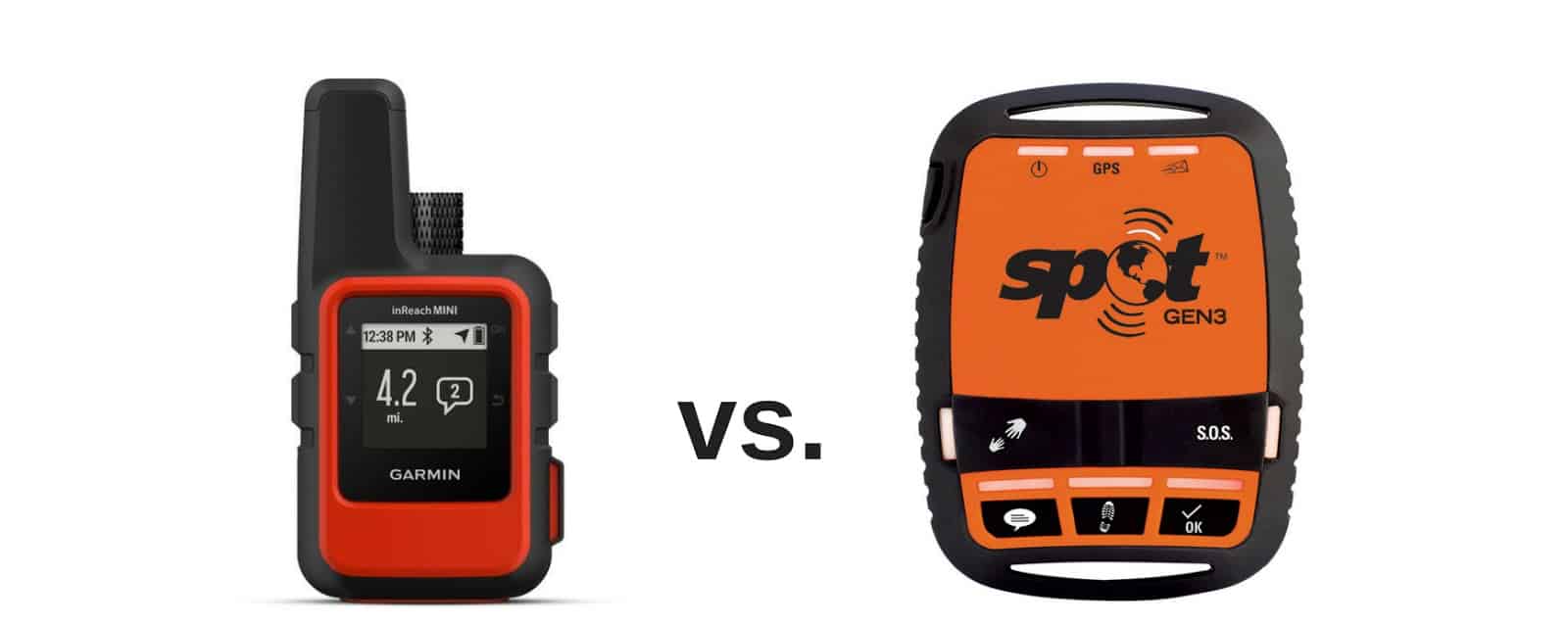
The Spot Gen3 is only capable of one-way messaging using a very limited number of predetermined messages (check-in/OK, help, and SOS).
Otherwise, the Spot Gen3 cheaper and simpler to use.
The Spot Gen3 is also half an ounce heavier than the Garmin inReach Mini.
The Spot Gen3 still occupies a niche where a user wants a cheaper device with cheaper service that offers limited check-in (“I’m OK”) and SOS functionality. However, the Garmin inReach Mini sets a new standard for the amount of performance and capability that can be packed into a package this small and light.
Spot X, inReach SE+, inReach Explorer+
The Spot X features a Blackberry-style physical keyboard, making it the best option for composing messages if you don’t plan to pair your messaging device to a Smartphone. Otherwise, the Spot X is much bulkier and twice the weight as the Garmin inReach Mini.
Garmin’s other inReach models, the SE+ and Explorer+, features everything the inReach Mini offers in a package that includes a color display that is larger and has a higher resolution. This offers two key benefits: the ability to integrate mapping functions on the device, and a better virtual keyboard.
However, pairing any inReach device with a smartphone and the Earthmate mobile app makes GPS navigation and mapping an entirely different experience (in a good way). Thus, my need for the mapping and display capabilities of the larger devices is replaced by my smartphone anyways. For me, replacing my old inReach device (the SE+) with the Garmin inReach Mini is an easy decision.
Somewear Global Satellite Hotspot
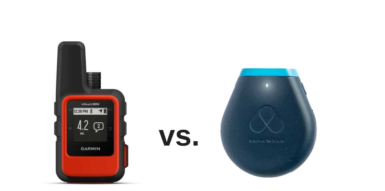
Although not yet on the market, the Somewear Hotspot will find favor among users who simply want to use their smartphone as their primary GPS navigation, mapping, and messaging interface.
Unfortunately, the Somewear Hotspot won’t offer any of these capabilities when not paired with a mobile device, rendering its functionality “extremely limited” in the case of a mobile device failure, or if you just want to leave your smartphone at home. As a standalone device, the Somewear Hotspot will still be able to drop pins so people back home can track your progress, and the unit has an SOS button. This makes it more comparable to a device like the Spot Gen3.
However, I prefer the full capabilities of the Garmin inReach Mini when considering its functionality as a standalone device: GPS navigation, two-way messaging, and weather forecasting are available, all without pairing it to a smartphone.
Service Plans and Pricing Structure
Garmin inReach service plans are somewhat confusing and offer too many choices. I like the idea of a la carte services (pay for what you actually use) for occasional/intermittent use and unlimited usage plans for power users. I abhor contract plans, change-of-service up- and down-charges, and service initiation charges. Complex pricing structures are the products of the industry of “finance marketing” that has infected most telecommunications industries today.
Garmin would do well to create goodwill for their consumers by simplifying their pricing structures, making them easier to understand and make decisions without having to consider formulas and breakeven analysis requiring charts and graphs.
Spot X service plans reflect a more consumer-friendly approach to device usage pricing. When comparing Spot X service to inReach service, Spot X service is significantly cheaper.
It’s worth noting here that the Spot X uses the Globalstar satellite network, while the Garmin inReach Mini uses the Iridium satellite network. User reviews of both networks reveal important trends that suggest a much higher level of reliability (especially with messaging) using the Iridium network.
Should I wait for the next new device to come out?
In the next 12 months, you’re going to see more players in the satellite hotspot market (with similar capabilities as the Somewear device).
But these devices won’t provide any new capabilities that can be had with currently available devices, which offer:
- Voice-calling and messaging (satellite phones);
- One-way messaging (tracker-style devices like the Spot Gen3);
- Two-way messaging and GPS units (inReach devices)
The primary limitation with today’s devices is the limited data bandwidth of the satellite networks they use.
Iridium is almost done building their new broadband network, with all of the satellites deployed and operation by the end of 2018.
Having used a broadband modem (Inmarsat iSatHub terminal) in the backcountry on a number of trips, the two features I find particularly interesting are:
- Voice-over-IP calling;
- Photo sharing.
So, the next wave of devices, available in 2019 and beyond, will sport these features and significantly change how we use devices for communications and trip sharing in the backcountry.
However, initial device costs and service pricing plans are expected to be quite expensive until market competition sorts it all out. If history is any indicator of the future, we are still three or four years away from seeing cost-effective consumer devices capable of broadband messaging, voice-over-IP calling, and photo sharing.
Until then, we can dream of the new inReach Mini+, a broadband-capable model that allows us to place and receive VOIP calls on our smartphone, post real-time photos from our trips to Instagram, and more.
For now, the Garmin inReach Mini is the market leader in this category, and will likely remain so for quite some time: it’s the smallest, lightest, and most powerful two-way messaging device on the market.

Availability
- Distribution of the Garmin inReach Mini is very limited right now. If you want this device in time for your next trip, we recommend purchasing the Garmin inReach Mini from REI online directly.
Disclosure
The author of this review purchased and owns the product reviewed herein. Some links in this review are affiliate links, which means if you click on a link to a retailer and subsequently make an online purchase with that retailer, Backpacking Light receives a small commission. This helps us maintain the site, create new content, and expand our product news coverage – we greatly appreciate this support!

Discussion
Become a member to post in the forums.
Do you mean you can export from Gaia to the Earthmate app? Earthmate seems pretty terrible to me compared to Gaia, so if that’s what you are referring to, I’m not sure I see the utility. “Navigating” a route using just the Mini is a non-starter unless there is some cleverly-hidden mapping feature I have missed.
Agreed. It doesn’t come close to Gaia based on my experimentation.
I disagree (I wasn’t talking about Earthmate map functionality). There’s utility to having a device with 10 days of battery power that will help you wayfind and give you your coordinates that doesn’t die in in 24 hours. Gaia is great for planning. But it’s non functional in the back country. Experts only need a map compass and gps coordinates. I’m not an expert. Sometimes I need a gpx file with a preloaded route (the background electronic map is irrelevant) to make sure you haven’t veered off course . Simply having these uploaded to the mini to check myself with a map is lighter and and last longer then taking the extra battery power to power a phone for enough check ins. It’s not about Earthmates usability, I’m just saying that you can get these routes on the mini on the fly. And that’s a distinct benefit over the only Other device in this weight class that can last 2 weeks on 10 min gps tagging, my suunto ambit 3 peak.
Okay, gotcha. I understand what you are getting at now.
I did a 10-mile loop hike today and uploaded that route (drawn in google earth) into my online garmin site beforehand, and then sync’d it to my Mini. Some of the route was on trails, and a lot was just open alpine terrain. I let the Mini do its thing in a pocket, and occasionally pulled it out to see what it was doing. ‘Navigating’ that route was very crude, but as long as the waypoints are located at critical junctures, reasonably effective. The route navigation on the Mini screen tells you the direction via an arrow (only works while moving because the unit has no actual compass and just interpolates your travel direction from successive gps positions) and the distance to the next waypoint. Presumably you are “past” a waypoint along the route when it is greater than 90 degrees to the side of your position/travel direction, because it then jumps to the next waypoint even when you didn’t pass directly over the current point. I wondered if this added gps work would draw the Mini battery down faster. After 4.5 hours I was at 88% battery (I started with a full battery), so nothing obvious there.
I think the biggest thing I wish for is still how to get Gaia gpx routes on the mini without my phone internet connection on the fly. Otherwise I think a good map and some preloaded routes in the mini for less then 4-5 oz total is a nice balance of safety and ultralight.
Piping in to say I have a terrible time getting a Bluetooth connection to my phone with the mini.
I keep the mini on while hiking to track but put my phone on airplane mode to save the battery life of the phone. When I turn on Bluetooth it takes forever to connect to the mini (10 minutes ofendless putzing around) Real bummer.
So the mini has no altimeter? That seems like a very shortsighted omission of a standard capability.
Hi Jeffrey when you look at your location it shows your altitude. Not sure if that’s based on maps and location or a real altimeter though . . .
I just used mine on a four day hike paired with my phone. I had an older Oregon GPS that never got used because the batteries drained quickly and turning it on and getting a fix took forever.
The Bluetooth on this thing does suck though. On a four day hike it connected to my phone fine then the last two days I had to pair the thing to my phone each time. This doesn’t take long but by the time I get around to trying the fix quite a bit of time has passed. I shouldn’t have to default to re pairing them each morning. I’m not sure what the resolution on the earthmap maps are but it’s nice to see them on a phone screen rather than a washed out tiny 2.5 inch screen.
I sent way to many texts this month wonder what the charges will be like . . .
Thanks for the info Patrick. Hopefully it does have a real altimeter. Can you get the cumulative altitude gain of the route you travel, either on the Mini or the Earthmate app? My old Garmin ETrex gives that, pretty accurately, but that functionality seems to have been dropped in the Inreach lineup, from what I understand (but not from first hand knowledge). thanks.
That info isn’t on earthmate unfortunately. It shows only the last tracking. Since the mini automatically goes into tracking mode my last track was 5 seconds just to check the battery power. No mention of elevation on it.
I’ll have to sync the mini with Garmin’s online software whatever it’s called. I’m hoping it syncs all the last tracks of done recently.
Patrick – Can you please tell us which phone you used that had Bluetooth issues with the Mini?
Has anyone been able to delete an uploaded gpx route from the website? I can’t.
Hi Kevin it was a Moto g5. I’ve never had problems connecting to anything else. There is a YouTube video of a guy having the same problems connecting to a tablet as well.
I’ve found that not all bluetooth devices work perfectly with each other. In my wife’s Toyota Highlander neither of us had any connection issues when we had iPhone 6 but when she upgraded to an iPhone 7 she had all kinds of wacky things going on while my 6 was just fine. Then Toyota did an update and she was good.
I’m getting ready to pull the trigger on a Mini and figured I’d found out if I need to anticipate issues with my iPhone 7. Thanks for your help!
This is pure conjecture but if the bluetooth connection problem is happening toward the end of the trips I wonder if it has to do with background app refresh rates when phones have low power modes that go into affect. For instance, the iPhone low power mode dose the following according to the Apple website:
Low Power Mode reduces or affects these features:
So, I’m reading some of the above posts correctly that if I wanted GPS functionality, just for say, the case of a whiteout & the surface/trail at my feet isn’t super clear, and I’ve preloaded everything in advance and I just want that little arrow to say “yep, go that way!” The mini would suffice?
I recently rented a stand-alone GPS device at the suggestion of the Iceland SAR agency. And I could see how if the conditions sucked bad enough for me to want GPS I might also not want to be dickering around with my nice, new wind-catching phone. Luckily I didn’t need it—did check in once when the trail present markers going in two different directions (confirmed both ways were good)—but it, an old Garmin Dakota, gave me a new appreciation for having a non-phone unit.
Reconsidered Mini v. Explorer+, but I’m still thinking Mini.
There is an arrow that appears on the mini itself. However, if you have a gpx route to follow the phone and map will be far clearer.
Despite aIl my whining about Bluetooth connectivity I really enjoyed using the mini and earthmate on a recent hike with some basic route finding and it saved me a good 30-40 minutes of backtracking over the course of a day.
For me I think the screen on the explorer would be to small.
A couple of questions reagrding the Mini and Earthmate onan iPhone.
Regarding #1, I mentioned this in an previous post (#3547900):
Another random note. When inReach is paired to an iPhone, any mapping app used on the phone will use the inReach GPS rather than the phone’s, additionally saving phone battery. Or at least that’s how it’s supposed to work, it seems that it can sometimes switch back to internal GPS, some details in this link:
https://icmtgis.wordpress.com/2014/03/05/using-an-external-gps-with-icmtgis-ii-on-ipad/
I don’t think there’s any way to manually turn off the iPhone GPS. Typically I’ll load offline maps for whatever app I’m planning on using, and then when I’m actually on the trail I’ll put the iPhone in airplane mode and pair it to the inReach. As mentioned this *should* use the inReach GPS, but may not always (on the iPhone, GPS has been enabled in airplane mode since iOS 8.3, see: https://blog.gaiagps.com/use-gaia-gps-in-airplane-mode-in-ios-8-3/). Even if it does sometimes end up using the internal iPhone GPS though, the battery savings from running in airplane mode are significant.
Some questions about the emergency uses.
I assume that the device does not use the same frequencies as a PLB/EPIRB – OK. But an activated PLB becomes a rescue beacon for SAR to home in on: does this device have such a beacon feature? (I assume not.)
A brief mention is made of the GEOS emergency service. Just how widely available is this around the world? I know the PLB is global, but is this? Does the Iridium network really cover all the world? Oh well, how about Australia?
What is the response time for the GEOS network in an emergency? Can they redirect immediately to the Australian emergency services?
How do I send an SOS with this device? Do I have to have a predefined emergency number like 000 or 112 and a predefined text message to send to that phone number? Or is there a separate SOS button or option?
Please note: we do not carry, nor do we even own, a smart phone. And we don’t want to. I am asking about this device for medical emergencies: broken leg, heart attack, etc.
Cheers
“nor do we even own, a smart phone”
join the 21st century Roger, get a smart phone
I’m going to get one too, real soon : )
From the Garmin site: “In case of emergency, trigger an interactive SOS message to GEOS, a professional 24/7 global monitoring center. Their trained staff is available to respond to your message, track your device and notify emergency responders in your area — giving you the peace of mind that help is on the way. GEOS will stay in touch with you and your emergency contacts until your situation is resolved.”
“How do I send an SOS with this device? Do I have to have a predefined emergency number like 000 or 112 and a predefined text message to send to that phone number? Or is there a separate SOS button or option?” – Separate SOS button on the device.
“does this device have such a beacon feature? (I assume not.)” – I don’t think a beacon, per se, but it sends your coordinates to GEOS, and GEOS can track the device if you’re moving. (At least I think that’s correct).
“Please note: we do not carry, nor do we even own, a smart phone.” – Not that you have one, but you could also pair it to an iPod and get the same functionality you’d get from an iPhone. But the inReach can be used as a standalone device – it would just be beyond tedious to type a message on it.
What’s nice about the inReach, especially when paired with a smartphone or such, is that you can communicate with GEOS personnel, so you can describe your situation after you’ve pushed the SOS – better informed rescuers are a plus, IMO.
“When sending a msg using Earthmate how do you choose between text or e-mail?” – I believe Earthmate sends everything as an SMS – you can send it to an email address or a phone number so that’s how you’d choose.
better informed rescuers are a plus
I wonder.
If you dial 000 here in Oz they send an ambulance (van or chopper) with two paramedics. I don’t think they change the on-board equipment before despatch. Of course, the ambos carry phones and can catch with ER when they get to you. Would they get to you any faster via the Mini?
I am struggling to see any advantage of the Mini over a PLB when used purely for emergency. And the PLB has much higher radiated power.
Interesting, and thank you.
Cheers
Answering some of Roger’s questions:
You are correct on all counts. The PLB homing beacon is intended for short-range search, typically by aircraft. As others pointed out, the inReach sends your GPS coordinates with SOS messages; so does a PLB if it gets a GPS fix. But in some settings, GPS fixes are unavailable or way off.
Potential Iridium satellite coverage is 100% global. Actual coverage is limited by US regulations (certain countries and regions banned via Iridium technology), and local laws that make carrying or using the device legally challenging. Australia isn’t on the banned list, yet :-)
When you push the physical SOS button, or activate SOS in the smartphone app, inReach SOS text messages go to GEOS for further processing, including notifying the appropriate local authorities. If your rescue service supports text or email messages, you could add those to your contact list and notify them directly through standard messaging. Activating SAR by text or email is not common in USA; I would also contact trusted friends and family, and rely on them to get help.
The inReach Mini is difficult and frustrating to use for writing and sending text messages without a smart phone. The larger and heavier inReach SE+ or Explorer+ are somewhat easier to use without a smart phone.
PLBs are “activate and pray” – you don’t know if the message got through, and you don’t know if or when someone might show up. Generally they work quite well.
When you have two-way communications with SAR, you get confirmation that help is on the way, which can relieve suffering; you can tell SAR how many people might need help and of what kind (e.g. swiftwater rescue or cliff rescue); they can tell you when and how they might arrive so you could (for example) move to a helicopter-friendly location; and they can advise you on potential treatments for which you might not be trained or equipped. Doing all of that by text can be challenging; that’s why some people carry satellite phones instead.
Also, an inReach can send tracking points. If you are unable to trigger an SOS, someone at home might notice that you are overdue or stopped moving, and activate SAR with a pretty good last-known position.
Finally, a PLB activation means “get me out of here now,” and SAR volunteers literally risk their lives to get to you as soon as possible. With an inReach, you can tell SAR that your ankle is broken and you are in pain, but rescue tomorrow morning is OK. I would have a hard time living with a SAR volunteer getting seriously injured or killed because I had a broken ankle and activated a PLB.
PLBs need more power to reach geosynchronous satellites that are about 50 times farther away than Iridium satellites. Many other aspects of satellite system design affect reliability as much or more than device power.
More background on satellite communications here:
https://backpackinglight.com/satellite_communications_sotmr_part1/
Hope this helps.
— Rex
Become a member to post in the forums.