Short trip for myself this year , 1/2 mile short of badger pass I postholed hitting a knee on a rock while twisting the other — not thinking the stiff leg shuffle would work well for another 70 miles , I bade good luck to the rest of the Mich. crew and started back to the start . As of this time they should make spotted bear this evening- (sun)-slow by many standards , but comitted to finish !
Topic
Bob Marshall Open 2019
Become a member to post in the forums.
- This topic has 155 replies, 26 voices, and was last updated 7 years, 1 month ago by
 .
.
I made it to the finish at 11:20am. Talked to James at the campground. Looks like I came in third with no boat . I will post a full report tomorrow right now I have a date with a tub of Epsom salt.
All weekend I’ve been wishing I was soaking up the Bob Marshall Wilderness again. I’m looking forward to reading the trip reports as they come in. 2020 will see me in MT again.
We got to swan lake cg a little after 5. Sore feet but no worse for wear. Trip report forthcoming.
I rolled into Swan Lake at 7:30pm on Sunday (35.5. hrs). Was a good trip. I’ll work on a trip report, but some brief highlights were:
Day 1 (37 miles walk)
– bumped into a griz alongside Strawberry Creek
– rafted 2-3 miles at bottom of Strawberry/Upper MF Flathead
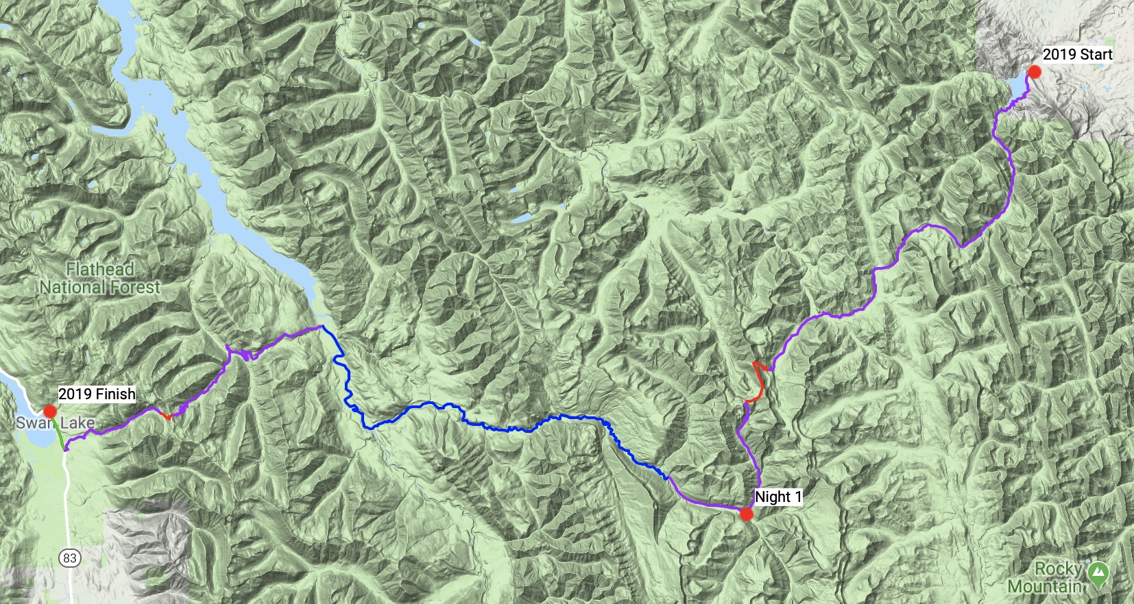
– tried out a new pass at headwaters of Clark Creek onto the cliffs of the Trilobite Range. Planned to do a ~9 mile ridgewalk to connect with Spotted Bear @ Dean Creek which would have been so cool, but dropped off after 2-3 miles into Pentagon drainage due to concerns about stormy weather returning and a lack of daylight to complete the alpine ridge route.
– arrived at Spotted Bear at 10:30pm. Called it a night early to save a few miles before the Spotted Bear Put In as a warm up in the morning.
Day 2 (51 miles inc. 24 walk, 27 raft)
– woke up at 3:45am to find a wood rat had eaten my PFD (and part of my InReach). I retrieved it from under the porch at the Pentagon cabin and tried to patch but too many holes inc. big chunks missing so I gave up. Made for a nervous paddle.
– hiked 5 miles to the Spotted Bear put it at 6 am
– rafted 27 miles on Spotted Bear and SF Flathead in 4.25 hrs.
– Absolutely horrific trail up Connor Creek. I was expecting easy miles but this was an old logging road that has been growing slide alder for the last 10-20 years. Not sure how Cairn has this as a major trail. Kudos to seemingly everyone for avoiding this.
– tried a direct route from the crest of the Swan Range down to Bond Lake. Lots of cliffs here but the alternative was a 3 mile sidehill past Trinkus Lake. I had Google Earth scouted this face and planned a line through the cliff bands. Worked excellently and replaced a 1-2 hour side hill with a 10 minute glissade/alder rappel.
– feet/legs were feeling good with my new blister strategy, so I was able to still move well (>3.5 mph) on the exit out Bond Creek and finish up in time to get to restaurants before they closed.
– still had 1000 extra calories in the food bag (ate 6k of 7k).
Congrats to Dan, James and Tom for finishing, whichn by any standards was very challenging weather and terrain- great job Gents!
Congrats to everyone who didn’t finish, but was willing to toe the line in what is always a huge undertaking; making a decision to bail is never easy, but in my experience, is almost always the right decision- live to fight another day
I’m not 100% sure I agree with John’s no “worse for wear” :)
Some highlights after the finish
-Thad put five beers in the creek as he washed up a bit, only to discover they floated off
-I was very popular as I had a cold six pack intact :)
-We found out (via a call to my wife) that many of the roads we needed to travel to retrieve Andrew’s vehicle were closed due to flooding!
-watched three guys limping like old men going into the Packer’s Roost (I am an old man, so that’s to be expected-watched there guys limping
-watched Andrew fully) consume a one and a 1/4 pound burger topped w/ a couple of cheeses, ham and bacon (the waitress set it down in front of him
-watched three guys limping like old men leaving the Packer’s Roost
-got to drive by our old home west of Hungry Horse (circa 1987)
-watched John multi-task while driving us around the incredibly curvy Highway 2
-made plans to all meet up this morning for a calorie intake and relive some of our adventure
I finished up at 4:10am on Monday morning and sacked out at the campsite.
Wow. The first two thirds of the route was fun, the last third was…memorable, let’s say.
I’ll have a detailed trip report out in a few days, along with a video as my vacation time here allows.
Day 1
I went with the group up to the pass above North Fork Birch Creek. 8 or 10 of us crested it within two minutes of each other.
I peeled off the Cox Creek trail to bushwhack a mile or so down to packraft the Middle Fork to Schafer.
I arrived just as pretty much everyone else did. The hikers were looking for a way to cross. I offered a ride across in my raft to Rob, who was already stripped down to his underwear. A funny looking ferry. Just after, Matt found a way to wade across without swimming.
I caught a glimpse of Tom, who had eluded us all at the first pass, but he was gone before I was packed up.
I headed to Whitcomb/Gunsight pass, but ran out of steam on the way up and camped on the snow at 6300 ft, 34 miles in.
Day 2
Woke at 4am to follow Tom’s and Matt’s tracks over the pass.
I bushwhacked a short distance from the road down to put in at the Spotted Bear River
The river was much pushier than when I had scouted it a few days before. I almost didn’t recognize the falls to portage. Super fun rafting though.
After rafting the South fork to Soldier Creek, I was going to head West up the North Fork of Conner Creek, but the road was too overgrown so I bailed to the unmaintained Conner Creek trail. This trail is hellacious. I feel like I had to move every single slide alder bush in that valley by hand in order to get through. I was following someone (turned out to be Dan), which was encouraging.
After the bad experience in the brush, I decided to continue on through the night to finish.
It was dark when I got to the top of the ridge, and Dan’s footprints went west instead of north as I had anticipated. Not trusting my own navigational judgement in the dark, I hesitantly followed as they plunged down a 45 degree slope toward Bond Lake, linking snow patches. High pucker factor here. That was quite a bold route choice, Dan.
The rest of the trail was downhill and uneventful, except for the hallucinations that started around 3am. Every single rock on the trail had a face on it. Some were cheering me on, some were leering at me. At least I had company.
Super fun and memorable trip. It was cool hanging out at the finish and talking to people as they came in. I get the feeling that if Tom hadn’t been held up till morning at the Quintonkon crossing he may have given Dan a run for his money.
“I hesitantly followed as they plunged down a 45 degree slope toward Bond Lake, linking snow patches. High pucker factor here. That was quite a bold route choice, Dan.:”
Ha…yeah it was a bold line. Probably even more bold for you, since I had at least looked it the satellite imagery and had the benefit of daylight. There were plenty of ways to go wrong if you lost my tracks and rushed down the wrong line. In Google Earth I noticed a lot of cliffs but figured it would go if I kept angling left. I didn’t cut hard enough left at first and nearly came out on top of a big one, but with the benefit of daylight I could see it coming and angled harder to miss it. In the darkness you might not have noticed but at one point the tracks were only 50 feet above a big cliff as I just missed the corner of it. I’m impressed you stayed on those tracks with all the gaps and alder rappels. Sure saved a lot of time.
“I get the feeling that if Tom hadn’t been held up till morning at the Quintonkon crossing he may have given Dan a run for his money.”
Yeah we almost had a group rendezvous at Soldier creek. I started up Soldier creek about 10:30 on Sunday, and per the tracking Tom had passed by about 10 minutes earlier, while Matt. L was along about 30 minutes later. So all three of us were in that area within an hour. Omitting Tom’s delay at Quintonkon, our times over the Swan Range were similar so we might have met at the finish.
We chose the southern of our 2 route options and happened to follow your tracks over Trilobite. we stopped and built a fire to dry gear when the rain stopped briefly and waited until light to climb it. It was rough. Blizzard. Whiteout. Your tracks when discernible were helpful that someone else had been foolhardy enough to go over. We too hoped the ridge would allow us to cruise down nearly to Dean Creek but we descended into the next bowl over from Pentagon. Kudos to paddling the upper spotted bear without a life jacket. It would have taken some nerve for me to paddle it with full gear. It looked unforgiving and fast. We got split up at silver top trailhead and lost 3 or 4 hours and were pretty demoralized. We ended up stopping at Spotted bear campground so we could rest before driving home and going back into classroom. Next year I’ll be back and look forward to packing my boat to get those boat miles!
Interesting that you planned the same ridge. Sounds like the weather made it a tough slog on the ridge. That’s what I was worried about, but the weather cleared for a few hours when I was up there. Felt very fortunate.
Approach the route on the ridge:
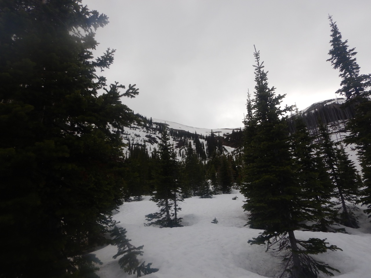
On top:


How was coming down Strawberry? Did you bring snowshoes or your skis? I found the snowshoes very helpful for that ridge. The snow was soft and I figured I post hole with or without them, but I tried them anyways and they worked really well. Very glad I brought them.
this year we spent more time on snowshoes than any Open previous; needed for the upper stretches of the N Fk of Birch Ck, all around the back side of Badger Pass, halfway down Cox Ck; the next day they went on again a couple of miles up Schaefer Ck, around and down Whitcomb; the last day not too far up Posey Ck they were needed again until we were up and over and dropping into the Swan
definitely a welcomed two-ish pounds! :)
I don’t have pics from the worst of the storm. I was soaked from the rain low and then the wind and snow hit us making things feel a little… spicy?
No skis. strawberry was great most the way. We were thrilled to find the cabin log jam… until we noticed it led to an island. There was another log jam to complete the crossing. The spirit of Bob Marshall smiles upon us. I’m curious about the upper spotted bear paddle and where you portaged at. We didn’t see any tracks. Kudos on going south from the start. I had considered that option originally but went herd mentality down Birch. Seeing your tracks in trek up to trilobite was the first human activity after Badger. George says he owes you a beer for the pseudo path through the blizzard.
Glad the tracks were helpful. My first year I was very glad to follow tracks over Larch Hill Pass in the Blizzard.
Gateway Pass was good. We didn’t put snowshoes on at all. We made it to the pass pretty much snow free by sticking to meadow areas, and then on the north side there was a mile or two of patchy snow but not too bad. We were down to Gooseberry around 4 pm I think.
For the Spotted Bear, I slept on the porch at Pentagon and then walked 5 miles to put in at Dean Creek, so I didn’t paddle the big canyon upstream of that. Downstream of Dean Creek, I only portaged the one major rapid where Big Bill Creek feeds in.
The real epic paddling is Will on the MF Flathead. He paddled Three Forks solo, in the rain, at the end of a long day, and un-scouted. That takes some real skill and courage to pull off.
Hey all, Rob here. I just discovered that this forum existed and am super bummed I didn’t participate in all the hype leading up to this thing, as well as the dinner the night before. Next year I’ll be more involved.
I finished Monday at 1:00 PM and didn’t see anyone around. I walked around thinking there might be a sign in sheet but after reading earlier entries here and I now see that was silly. This my first Bob Open and I’m super happy about it. I have a decent amount of long trail experience (Dan helped me prepare for my GDT thru last year), but I found this to be way more interesting.
I took what seems to have been the standard route. I made it about 5 miles up Schafer Creek after thumbing a ride across the Middle Fork with James, and called it quits around 9 on Day 1 (~30 mi). It honestly didn’t occur to me night hike but I guess that’s requisite if you’re going to finish in the top 3.
I then slept in a little too late Sunday morning, but made quick work of the climb and descent of Gunsight Lake Pass and then proceeded to run/walk 16 miles of road. It was efficient, but boring and probably against the spirit of this event and something I’ll try to avoid next year. I then made it over the gentle pass near Soldier lake and found a cool camp at Connor Creek around 7:30 for another 30 mile day. I wanted to keep going but knew the trail would suck so I called it early and vowed to wake up early instead.
I managed to deflate my pad around 6am, and spent the next few hours battling the slide alders up the old road. I started seeing tracks and figured the leaders knew best so I followed along and let my mind rest. After slogging up and over the pass and I also opted for the steep descent to Bond Lake. I almost got cliffed out but managed a sketch downclimb with no problems. It was pretty straightforward after that and an easy drive back to Missoula.
The energy of the event really took me over and I enjoyed hauling ass (although when I woke up this morning I felt like I had been in car wreck). I’m still psyched about it. I look forward to shaking off the first timer mistakes (didn’t get hungry enough to justify bringing a stove, buy an Alpaca and utilize the rivers, wake up earlier and hike later into the night, snow actually can accelerate your pace and open up efficient off trail alternates, take better care of my feet, identify the most logical route and then do something more interesting, attend the pre-Hike dinner, etc) and improve next year. I’m kinda wishing there was an early winter sister event. Might get shot in the Bob during hunting season but Yellowstone could be cool. Food for thought…
Congrats to all of y’all and thanks again James for keeping me dry.
-R
congrats Rob :)
Dan M- any word on any of your crew?
is there anyone else out there still (besides possibly the Michigan crew)?
I know we had 24 starters and that leaves a lot of folks unaccounted for
Congratulations on your finish Rob. The wilderness classic in Alaska will make you a man but requires a boat. I would love to jump in an even less official but equally fun activity… beartooth pass to west rosebud? Dubois to Meteetse? Lander to pinedale? If enough hands went up in interest I’d be game.
Congratulations to all of y’all. Really impressive times Tom and James without any paddling. Dan I guess you did okay too.
Heres my full TR, a lot shorter than last year’s. I only took video this year and my camera died around 6 or 7 the first night, but I’ll get some clips uploaded at some point.
I caught a ride to the start with Dan’s friend Jim, who cooked us cheesy omelettes and oatmeal in his trailer for breakfast. I definitely started the open a lot fuller than usual. On Friday evening Dan helped me convince myself to A) go over gateway with him to get to my put-in on the middle fork and B) to leave my sleeping bag and push the pace. The first was a great choice. The second was a bit more questionable, but almost certainly was moot in the end. My major goal for the Open this year was to run it without any mistakes; I didn’t want to finish because of luck like last year. As Dan can attest from watching me drop my visor and a snow cup on my trekking pole on the way to gateway I didn’t run it clean, but I did reduce the potential seriousness of my mistakes by an order or magnitude.
We started hoofing pretty quick out the gate after the group picture. I felt good all afternoon on the flats, but already that morning didn’t feel 100% on the climbs or off-trail. It wasn’t seriously challenging keeping up with Dan, but I was definitely the one keeping up and I could tell I would have made slower time on my own. I also had the strange experience of basically following him blind over gateway since I didn’t really look at the route in detail after deciding to do it. But it was excellent travel- easy crossings of SF birch, beautiful views and very very little snow. The latter was especially important for me since I left the snowshoes in my car. All the way until the last half mile to the pass the trail was clear of snow, and for the last half mile we more or less stayed off of it by staying out of the trees on game trails above the pass. As we dropped down and crossed the meadows we encountered some isothermal slush, but overall it wasn’t too bad. We managed to make pretty good time over the most challenging section at the top of gateway gorge by following the couple feet of exposed ridge that dropped off into the river on the south side before crossing to the north side around the cabin where the river bed opens up. Before long we caught the snow-free trail again on this southern aspect. I had to poop again before the trail hit strawberry creek which was strange for me and a sign of things to come, and Dan continued on from there after a quick goodbye. After an hour or so of heavyish rain along strawberry creek I caught back up to him as he was getting ready to put in. I had hiked most of the day wearing just underwear, but stupidly put on my hiking pants underneath my rain paints when the rain began. They completely wetted out, which came back to bite me when I tried to sleep that night. In an act of true amicability he burned ten or fifteen minutes helping me transition to the water and we put in on strawberry together. We paddled and portaged to gooseberry by 4ish, when we split up for the last time. I lost some time in the headwaters when I had to pull out and poop yet again, but I made it up to Schafer around 6:45. The headwaters felt fuller than I’d expected and I guessed they’d swelled with the rain. Looking at the gauge the MF was running at ~6900 CFS while I was on it but by the next day had risen to 10k. The higher water was good because the river was moving fast but made me nervous for Three Forks. By the time i reached Schafer my adrenaline was seriously pumping. Enough that I when I floated by John, Thad and Mike and they asked if I’d seen Andrew I didn’t even think to stop and ask if they needed help trying to find him, which I felt bad about once I was through Three Forks and the adrenaline had worn off. Sorry guys, glad he showed up no worse for the wear.
I got to Three Forks a bit before 8 and had the clear highlight of my trip. I felt super capable, boat scouting all the rapids without any close calls. At that level there were plenty of tough moves and plenty of must-make moves and just the right amount where the two overlapped to get me totally in the zone without being scary. By and large I avoided the holes, but I did forget Dave’s beta about the rapid with the boulder in the middle and had to punch straight through the channel-wide hole below its left side. I definitely could have run the rapids in my Yak, but the Wolverine took them down from feeling hairy to feeling totally manageable read-and-run. If I had to go back and do it over I probably wouldn’t carry the extra 3 pounds for the wolverine below 8 or 9k cfs, though.
I made it to Granite just as the light was failing. I started hiking up to Spruce Park at around 10, and reached it around 2:15am for a nearly 60 mile first day. I was satisfied and thought I was set up well for a finish the following evening. Totally exhausted I set up my tarp and tried to sleep, with pretty much 0 success. Since I’d eschewed my sleeping bag my sleep system was to wear my drysuit over my insulating active layers (baselayer, R1 hoody, nanoair light). Stupidly, though, I’d worn my R1 inside the drysuit to paddle. The R1 had gotten wet hiking along strawberry, and it brought a lot of moisture into the drysuit. Same goes for my hiking pants. I had dry long Johns for sleeping and wore my just-damp nanoair next to my skin, but there was just too much moisture inside the drysuit. I was already just on the verge of having insufficient insulation, and the wetness made sleep impossible. The drysuit also generally added less warmth than I’d expected. After 3 cycles of sleeping for 5 minutes, waking up shivering, and doing crunches to warm up the sleeps had gotten shorter and the shivering more violent and I decided I had to pack up and get moving or risk hypothermia. I blew up my boat in the darkness and crossed the MF just above spruce park. I hiked down long creek and just as I turned onto bergsicker I started feeling awful. At first I thought I was just cold so I hiked a bit faster, but I could feel sweat starting and still felt bad. I thought I might be hungry but looked at my food and couldn’t imagine eating it. Just after 4am I threw up.
I knew I was probably sunk at this point, but I wanted to wait and see if it was one of those quickly passing stomach things. I started trying to make a fire but it had been raining steadily in the area at least since I’d gotten there, and in the darkness I couldn’t find enough dryish wood to really get anything going. Since I’d forgone a stove as well I couldnt make a hot water bottle either. Left with the options of staying still and getting hypothermic, going further on a big calorie deficit and a bad stomach, or bailing just 6 miles out to bear creek, the choice to bail was easy.
One thing that struck me is how much worse I did with 0 sleep this year than an hour and a half last year. This year I felt totally wrecked sleep-wise. By the time I was on highway 2 trying to get a hitch I was falling asleep while walking. But I don’t think the issue was just overexertion and lack of sleep. At this point it seems I was probably experiencing the onset of Rocky Mountain Spotted Fever. That day I slept most of the day and I’m the morning I felt okay, but by the following afternoon I felt truly horrendous. I’d gotten a tick bite on the ride to the start, and when I went to the ER they found a rash starting on my feet and guessed I’d probably gotten an infecting bite while I was in the Bob the week before. I get the test results in a day or two and let y’all know for sure, but they seemed pretty confident and put me on doxycycline.

It was definitely a big bummer to bail, but I had an awesome day and can’t wait to be back next year.

Im still working on my trip report however this is why i had to stop for a bit at the posey trail head. I had an accident at the last crossing in cox creek early on that first day. More to come soon! Great trip report Will !!! and you should definitely get back to Bergsicker sometime its an awesome basin.
^ that’s pretty close to what both my feet like (w/ the addition of couple of blackened toenails) and that’s sans accident! fun stuff :)
HAHAHA!! good stuff Mike It was a pleasure to meet you, your wife and the entire Helena crew. It would be an honor to share a campfire with you guys in the backcountry sometime. I am always down for a trip so please keep me in mind and i will do the same.
You remember the calendar we were joking about at the start? Looks like we have January and February all set.
Holy #$%^ Will. Onsighting 3 Forks at dusk at that flow is super impressive. Your bivy reminds me of mine 7 years ago, huddling under a tarp desperately trying to keep a fire going as the snow piled up, fighting off puking and not able to eat. It’s a scary feeling, running out of ways to keep warm. Brought a sleeping bag on every trip since. ;)
Well done to everyone. It’s always enjoyable to read these, and even moreso with folks making good (but bold) decisions in the face of challenging conditions.
Background for everyone; the lack of clarity and support (e.g. sign in/out, formal details about start meeting) has and will continue to be intentional. For years the Open has been a few steps away from gaining momentum and having significant bump in participation, and my concern has always been that when/if this happens an inevitable corollary will be someone showing up unprepared and getting hurt. Before the Open I organized a few similarly unstructured mountain bike events, and having to have the come-to-jesus conversation with someone about not starting (or having someone show up, bail, and then lie about having finished the whole course) is something I’d like to avoid if at all possible. To say nothing of the safety concerns the land managers might have. The FS showed up the first two years before deciding we’re small and safe enough to not be a cause for concern. I aim to keep it that way.
The proto-proto Bob Open was my late May traverse of Yellowstone in 2010, which was scary as heck and really opened my eyes to how awesome big traverses this time of year can be. The park service isn’t interested in sanctioning something like the Open, and I don’t blame them, which is the only thing that has kept us away from Yellowstone (going outside the park restricts the course area too much).
The survey I put out last year was quite clear that the majority of folks, especially those who aspire to but haven’t yet done the Open, like the classic course options and date. So I’m going to keep that.
My own interests pull me elsewhere, and so long as I keep my current career I’m unlikely to be in a good mental space for the Open so close to the end of the school year. So I’m already planning an Open-esque trip of my own for early next May, either in the Bob or elsewhere, and if folks wanted to coordinate to make it more of a fast group trip that could be a great second option. A late fall Yellowstone traverse this year would also be very cool.
“HAHAHA!! good stuff Mike It was a pleasure to meet you, your wife and the entire Helena crew. It would be an honor to share a campfire with you guys in the backcountry sometime. I am always down for a trip so please keep me in mind and i will do the same.”
Tom- ditto. Looks we share a lot of common interests. We’re definitely going to try another go at traversing the top of the Chinese- hopefully sans forest fires this time.
I’ll shoot you a private message and we can exchange emails and stay in contact.
Mike
Congrats to Dan, James and everyone who toed the line. It was bitter sweet to see James at the finish but I know he put in a lot of effort to prepare for this and it paid off.
” Absolutely horrific trail up Connor Creek. I was expecting easy miles but this was an old logging road that has been growing slide alder for the last 10-20 years. Not sure how Cairn has this as a major trail”
We need to work on your map skills Dan. If the trail has red and black dots this means secondary trail that gets “possible infrequent maintenance” AKA jungle. Hahaha! Part of my scouting involved talking to a fellow bow hunter that hunts that area and I was advised to steer clear at all costs. So kudos to everyone who wrestled with the alder. Here is my trip report————
<u>Day 1</u> 42 miles
Leaving that morning I had a plan to keep my normal pace sleep a few hours and be out in two days. In planning my route knowing people with boats were unable to float at night I tried to use that to my advantage. At the start the weather was perfect cool and overcast. It was extremely difficult watching James and Rob getting farther and farther away but I kept to my plan. I caught up to them at the first batch of snow near the head end of Birch. The snow was consolidated and made for good travel without snow shoes. We leap frogged a few times towards the last pitch to the pass. I stopped short took a break and decided to devour some calories and it also allowed me to try out a plan I had in place beforehand. My thought was everyone would try to route find the trail to beaver lake witch was buried under snow and I was right. That morning I had already set my compass heading from the pass to beaver so when everyone filtered down the path of the trail I made my move. With my compass in hand and snow shoes on my feet I got out in front of everyone taking a direct line to beaver. I soon got on a young grizzly track around beaver lake and followed it in the snow. In my experience they have been using the trails generation after generation after generation and as long as they are heading in the same general direction I will always follow their tracks.The snow ran out way sooner than I thought and I was on clear trail. I was pushing the pace maybe a bit too hard and at the last crossing on cox creek just below wapiti park I made a mistake. I tried to just power through the crossing instead of slowing down and making sure my footing was bomber. Halfway across my right foot got lodged between two rocks and with my forward momentum it felt like I ripped my foot completely off. I went face first into the creek completely soaking me head to toe. I have a history with this ankle its held together with two 4” metal plates on either side and 12 screws from an injury in 1996. I pulled my shoe and was able to wiggle my toes so I figured just go with it as far as I can go. It was painful but manageable. My focus turned to the fact that I was drenched head to toe and the rain had been steady since the pass. That’s when things got a little strange. I was having a conversation with myself out loud please don’t judge.
Quote: “Can I use the clothes dryer at Schafer Meadows?”
“No”
“Why not. Would that be considered outside help?”
“No that’s not why you can’t use them. You can’t use them because they are coin operated and
You didn’t bring any quarters with you”
I had a good chuckle all the way to the middle fork forgetting about the pain in my ankle. I hurried up and got all my gear into a dry bag and started to cross the river. I knew it was going to be a swim but I wanted to see how long I could stay on my feet. Not long and it was swim time. When I got to the other side the sun came out and I cooked up some mashed potatoes sat by the river and ate my dinner. First came Rob and he was looking for a place to cross. I pointed out where I entered the river and said prepare to swim. Then Matt showed up right behind him and yelled “Tom is that you? How the heck did you get in front of us?” James then showed up in his raft I’m assuming have floated from cox creek and started to prepare to ferry Rob across and Matt getting ready to swim. I headed into Schafer creek but after a few miles my ankle was screaming so I downed two of the six NSAID I brought with me. I kept moving up the drainage and made good time until daylight was gone. Using my new headlight I bought specific for this trip a Princeton tech Apex pro with 550 lumens lit up the woods and allowed me to reach the pass gunsight pass just before 11pm. I started to decent whitcomb drainage with my ankle screaming again so after crossing the creek near the bottom I stopped to rest and eat then I saw a headlight coming down off the pass so I wolfed the last of my refried beans, let out an Indian war cry and off I went. My original plan was to get to the Billy garret bridge by 4 am and sleep for a couple hours but I opted for the bridge at trail creek after 3am for my shelter. I learned a long time ago bridges make for a great shelter and a great opportunity to do some arachnology. I fashioned my pad right next to the creek so I could have my leg in the creek and the rest of my body in my quilt. I went to sleep.
<u>Day 2</u> 26 miles
I woke up to water dripping on my face at 5am so I pulled my popsicle for a foot out of the creek made a cup of tea and had some yogurt and granola. The ankle hadn’t swollen any more than before and the pain was the same so I took two more NSAID and crawled out from under my 3 Billy goats gruff /Hobo Jungle. Rain was steady and knowing I had a long road walk ahead I put my head down and started grinding. I forced myself not to look over at the burn area above spotted bear ranch because I can’t pass up a morel if I see it and I’m sure they were in there. The miles seemed to drag and it was hard to keep a positive attitude so when I got to the scenic overlook just past the airstrip I pulled off and sat on the bench and gathered my thoughts. I struggled with the vibe of attacking the wilderness and not moving through it with more continuity. It had been heavy on my mind from the moment I decided to do the BMO. After some food and a self-pep talk off I went and slowly but surely I got to the Quintonkon road and I could visualize the finish line however at 4:20pm having reached the posy creek TH and the Quintonkon creek crossing the pain in my ankle was so intense I wanted to piss myself every time I planted that foot. I made the call to set up for the night knowing I only had a three hour hike to Swan lake CG. I put my foot into a small dry bag and packed it full of snow and went to sleep.
<u>Day 3</u> 9.6 miles
Slept like a log that night and woke up feeling good except my ankle so I downed the last of my two NSAID and started looking for a way across Quintonkon creek. I got over and started up to the trail and much to my surprise no tracks in the snow. I figured for sure someone strolled through my camp while I was sleeping. Made it to the pass and the intersection of trail 7 and still no tracks which gave me the boost I needed and off I went down the hall lake trail to swan lake camp ground where my wife was waiting. She had walked through the campground before I arrived and ran into James so I grabbed my lunch and went and talk to James for a while. It was fun to share trip stories with him.
I feel honored to be a part of this group and enjoyed the little time I had to spend with everyone. As soon as my leg is healed I will be back in the Bob.
<u> </u>
<u> </u>
<u>Trip Highlights:</u>
-Meeting like-minded people who have a passion for the wilderness.
-Swimming the middle fork.
-Drinking Tazo green zen tea under a bridge like a hobo and feeling compelled to raise my pinky only to crack myself up.
-taking time to stop at the overlook to gather my thoughts.
<u>Trip observations:</u>
-Brought way too many calories.
-Didn’t bring enough NSAID’s
-snowshoe bindings need some tweaking. They kept coming loose on me.
-not a big fan of the Z packs pocket tarp any slight bend in your sleep position and your beyond the coverage of the tarp.
<u>SEE EVERYONE IN 2020!!!!</u>
Great trip report. Nice job out there and thanks for sharing. Nice move sleeping with one foot in the creek. Likely next year there will be fewer road miles. It was nice to get into the NE part of the Bob this year, but it did take the event into a more roaded area than usual.
For NSAIDs, I use Aleve and carefully count out the maximum number I’d be okay consuming, so I don’t damage my body over-consuming them when I lose count, but also don’t have less than I could. My bottle said a max of 3 per day, so I hoped to keep it to 6 (3 per day x 2 days) but packed 12 (4 per day for 3 days). I also find a preventative Aleve taken at the start helps a lot, because it lets me get out ahead of inflammation instead of trying to bounce back from it.
“We need to work on your map skills Dan. If the trail has red and black dots this means secondary trail that gets “possible infrequent maintenance” AKA jungle.”
Ahh I see what happened here. I have an older version of the Cairn map (circa 2012-2013) that uses the same system, except on my map the Conner Creek trail is shown in solid black as a primary trail. They must have realized this error and corrected it on newer maps.
Become a member to post in the forums.
advertisementYour privacy is protected: We do not transmit your user data to third-party ad platforms or advertisers, and we do not host third-party tracking pixels. Backpacking Light serves ads on its own custom, native, and internal platform.
 New Ultralight GearSee the latest releases in ultralight cottage-brand gear from small makers.