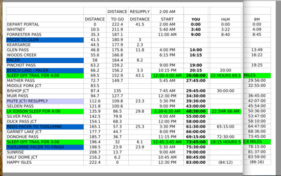
As far as I know, you can only see 50 points at a time. The owner of the device can download all the track points to a gpx or kml file after the fact, but I believe you have to do this within about a week or the points just disappear off the web. It would be cool if their team downloads the points and makes them available to future FKT aspirants.
As far as nighttime navigation, I'm sure they have excellent headlamps and maps, and perhaps GPS. Navigation on the JMT is easy. When I did FKT runs in 2000 and 2003 we did not have GPS and had basically no navigation issues. That was, in 2000 anyway, with no prior knowledge of the JMT, while Jenn at least has spent a bunch of time on the trail. Both these ladies are very experienced navigating on trails at night!
As far as I can tell they took two breaks of approx. 90min. each last night. This is more than most JMT FKT-ers have taken on the first night, but may serve them well as the trip unfolds (assuming they got some sleep). Whether they are ahead or behind at this point is probably irrelevant – it's what happens in the last 24 hours or so that matters.
Exciting to watch!