Topic

Rough Cilicia, Turkey, 25th-28th April 2013


Forum Posting

A Membership is required to post in the forums. Login or become a member to post in the member forums!

Home Forums Campfire Member Trip Reports Rough Cilicia, Turkey, 25th-28th April 2013

  • This topic is empty.
Viewing 19 posts - 1 through 19 (of 19 total)
  • Author
    Posts
  • #1303085
    William Chilton
    BPL Member

    @williamc3

    Locale: Antakya

    This is my first trip report. Until now, I’ve been somewhat intimidated by the high quality of the trip reports and photos on this site. However, this trip seemed sufficiently different from others to embolden me to post it here. A fuller report can be seen here: https://www.dropbox.com/s/zio1zcy6nmxgx5s/Kizkalesi%20April%202013%20Trip%20Report.pdf?v=0mcns
    The GPS trace of the trip can be seen here: https://www.dropbox.com/s/ir3ujji4p1b43dk/Kizkalesi%20April%202013%20combo.gpx?v=0mcns

    A LITTLE BACKGROUND.
    The trip was in an area of Turkey which in Roman times was called Cilicia Trachea (Rough, or Rugged Cilicia). It was heavily populated from Hellenistic until Byzantine times, approximately the 2nd century BCE to the 7th century CE. It was then rapidly depopulated. It is currently almost unpopulated outside of a few isolated villages, except for the winter camps of nomadic goat herders.
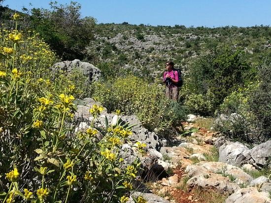
    Nowadays, the area is mostly covered by thick maquis. This consists of a wide variety of mainly spiny vegetation, which is impenetrable except for some narrow goat tracks, or where the ground is too rocky for the vegetation to thrive. It is limestone country, so water sources are very scarce. The ancient settlements were usually supplied by cisterns. The current herders truck in tankers of water, and their camps are next to the few roads in the area.
    The ancient towns were surrounded by extensive areas of terracing for crops. These are now usually completely overgrown, though some remain clear of trees and bushes. The towns were linked by paved roads, and the ground for these roads was cleared of loose stone, which was piled up along them like walls. The traces of these walls are visible on Google Earth, and that is how we planned this trip.

    DAY ONE. Distance walked: 4.33 km, altitude gained: 324 m
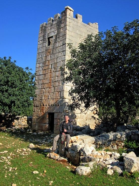
    The bus dropped us off in the seaside resort of Kızkalesi at 11 pm. We to hike north along a road for about three miles to where we knew there is a Roman watch tower with some clear terraces for the tent. (Thanks to Dan Yeruski for suggesting that a six and a half hour journey merited three nights rather than two.)
    There are a number of shepherds’ camps along the road and we were a little worried about their dogs – shepherd dogs in Turkey can sometimes be vicious. Far ahead of us, dogs would start to howl as they somehow sensed us coming but we only came across one which had been left to roam free and fortunately he was all bark and no bite.
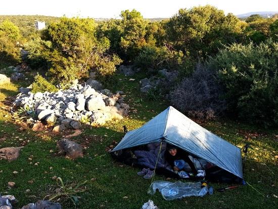
    We arrived at the Roman tower and pitched the tent by the light of the full moon.

    1st camp

    DAY TWO. Distance walked: 14.34 km, altitude gained: 497 m
    We were awoken at 6.30 by the light and by the sound of cowbells. After a breakfast of coffee and cereal bars we made our way back to the tower.

    Roman tower

    A short walk back down the road brought us to the remains of a Byzantine town now called Hıdırlı, The remains include a pleasant church and a bathhouse.

    Hidirli church

    There is also a short stretch of paved road. We visited here by car about twelve years ago and it was this stretch of road that first made me want to come back and explore this area.

    Hidirli ancient road

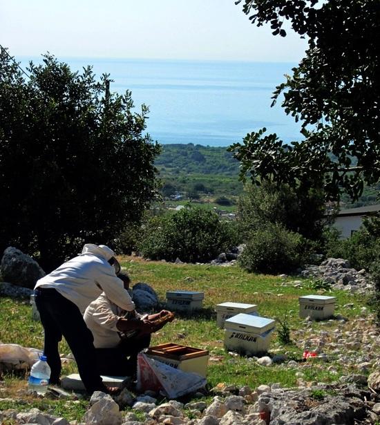
    We continued down the modern road the short distance to the upper part of Kızkalesi, passing beekeepers.

    Beekeepers

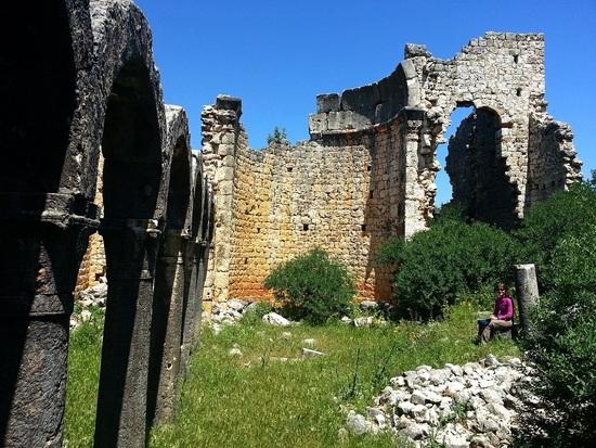
    A dirt road led us past another Roman tower to the edge of the extensive Byzantine town of Korykos. We reached the ruins at the remains of the 5th/6th century Transept Church, the easternmost of the six churches that are identifiable (the town once had ten).

    Transept Church

    The largest church was the Tomb Church.

    Tomb Church

    We continued a fine section of the sacred way east towards the sea.

    Sacred way 1

    Sacred way 2

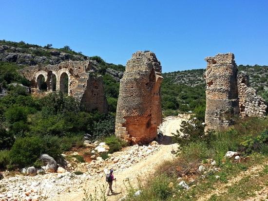
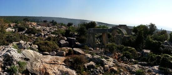
    Before reaching the coast road, we cut back uphill to the level of the aqueduct which supplied Elaeousa-Sebaste (now Ayaş) and followed its channel around the hillside before scrambling down to the small valley below.
    We passed below the arches of the aqueduct then turned right towards the village of Ayaş.

    Ayas aqueduct

    We came out right at the top of Elaeousa-Sebaste’s 2nd century theatre, with a clear view over towards other ruins on what had been an island in antiquity.

    Elaeousa-Sebaste

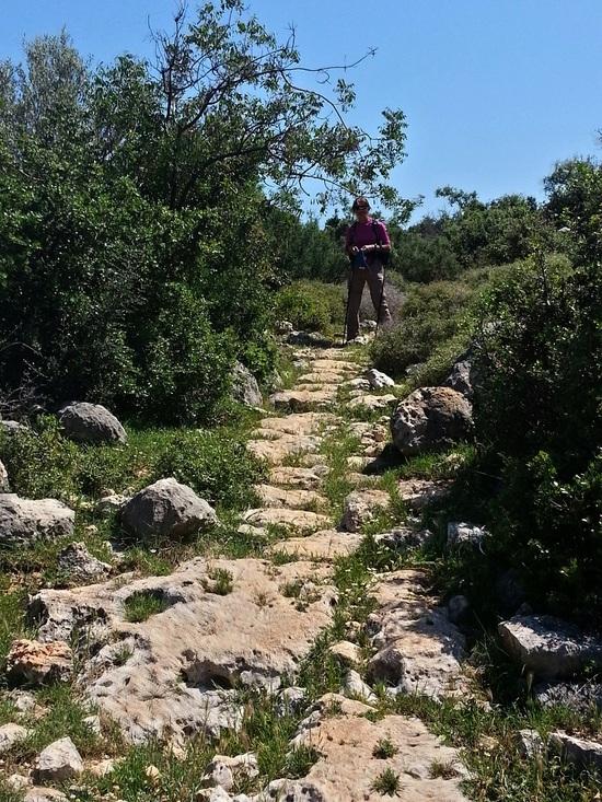
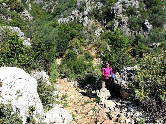
    We filled up with water at a house in the small village of Ayaş. Above the village, we turned onto a faint animal path that bore off on the right. It was indistinct and hard to follow at first, but grew a bit more obvious and suddenly we found ourselves walking on ancient stone paving. Although we’d walked on sections of paving in the ruined towns, it was exciting to finds ourselves walking on it out in the middle of the countryside.

    Ancient road

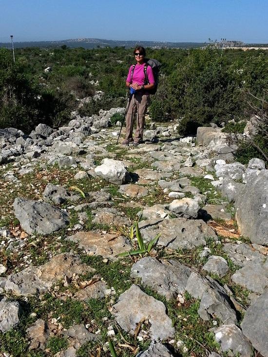
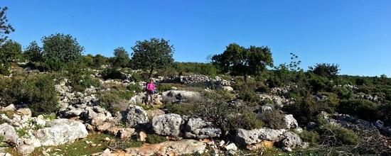
    The track was overgrown in many places and we often had to detour on to the piles of stones alongside to avoid thorny bushes.

    Detour

    We were too late for the best of the wildflowers, but the Jerusalem sage was in flower.

    Jerusalem sage

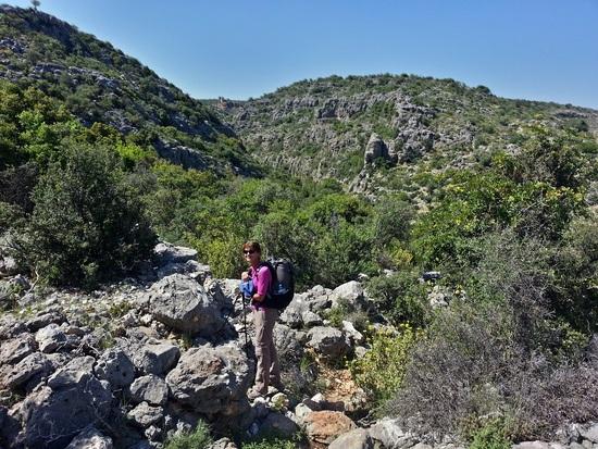
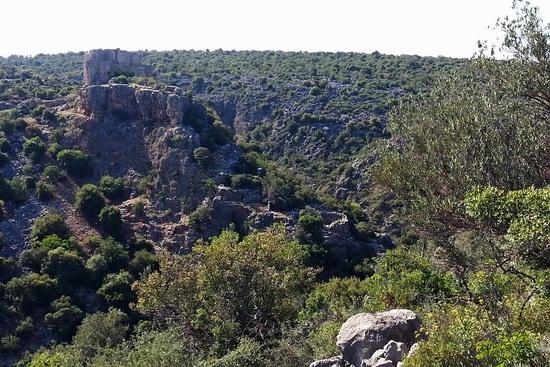
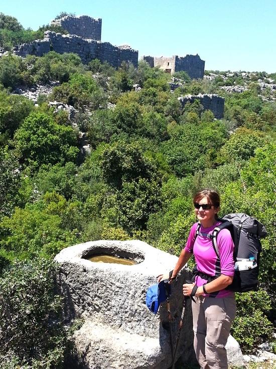
    The track led down into a gulley, guarded by a spectacular fortress standing on a rocky outcrop. This was Hisarınkale (Castle of the Fortress), originally a Hellenistic settlement (probably 2nd century BCE).

    Hisarinkale

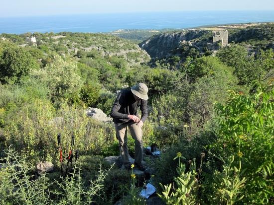
    A short distance farther along we came to terracing below some heavily overgrown Roman ruins. It was still a little early to stop, but we knew we were going to have to dry camp and the day was still hot so we decided it made sense to stop and conserve water.
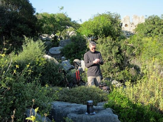
    We “cooked” a meal on the edge of the ruins with a fine view down the gulley to Hisarınkale while we waited for the sun to get lower.

    Cooking 1

    Cooking 2

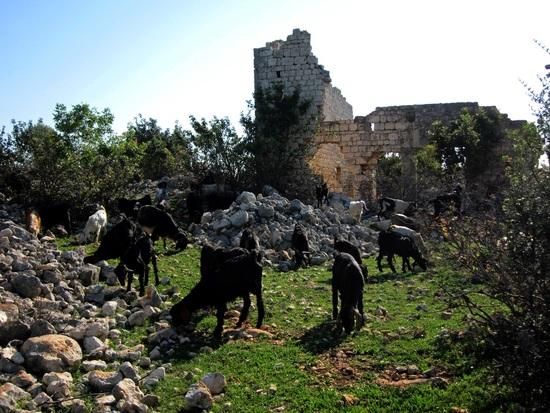
    While we were waiting, a herd of goats passed by. The dog contented itself with barking at us from the other side of the bushes until all the flock had passed.
    We put the tent up to the sound of goat bells in the gulley below as dusk gathered, then hit the sack as the moon rose over the ruins behind us.

    DAY THREE. Distance walked: 17.04 km, altitude gained: 678 m
    The light woke us early again and we had coffee to the sound of goats getting moving on the other side of the gulley below our terrace.

    Camp 2

    We headed off through the terraces, stopping only to watch a caterpillar train. These caterpillars make cobwebby nests in pine trees, and when they move on they do so in a line head to tail. They are covered with long hairs which are incredibly irritating to the skin if touched.

    Caterpillar train

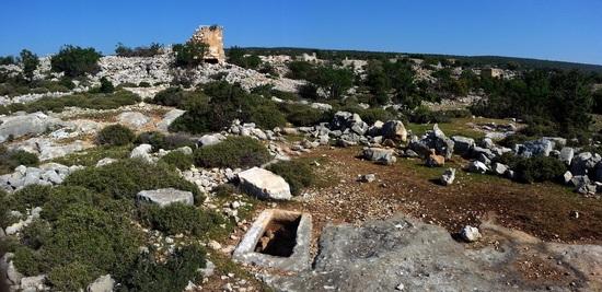
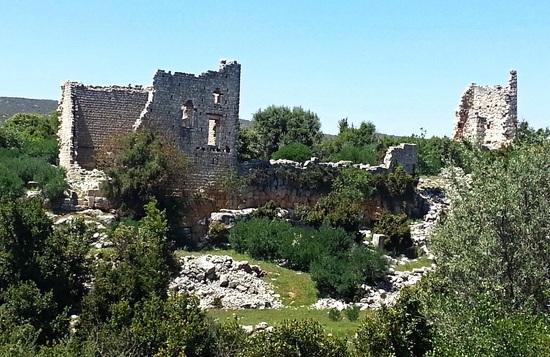
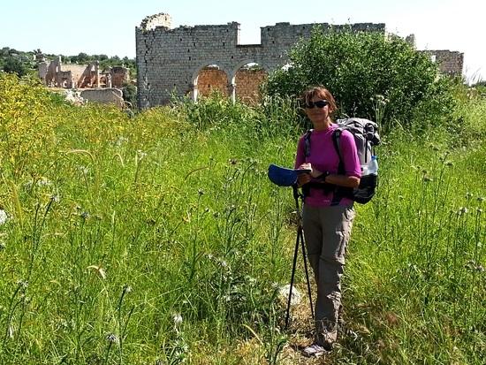
    We picked up the trail again beyond the terracing and followed it to another area of terracing with a tall ruin ahead. This turned out to be the apse of a church, which stood on the edge of an extensive area of ruins from the Hellenistic period through to the Byzantine. (The next day, we found out that the modern name for these ruins is Kabaçam)

    Kabacam 1

    Kabacam 2

    Beyond terraces crisscrossed by goat tracks, we picked up a clear path which soon became paved again as it headed towards a gulley.
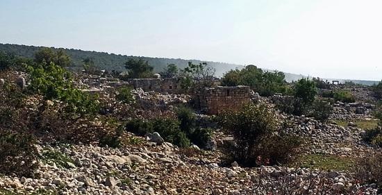
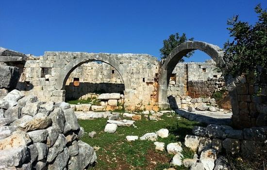
    On the far side we took a wide track which led to a dirt road paralleled by the ancient road. This led us to a gulley strewn with ruins, the ancient town now known as Çatıören. On the other side of the gulley, there are the impressive remains of a Hellenistic fortress and temple.

    Catioren temple

    We followed the track past Byzantine dwellings to the remains of a large transept church where we rested a while in the shade.

    Catioren church

    We were now keen to get hold of water, so we took to the dirt road (which has obliterated the ancient road), to Poşlu Mahalle. There was a water fountain and shade next to the mosque so we sat ourselves down and drank our fill.
    On Google Earth, there is a very visible crater (a sinkhole) near Poşlu Mahall. I asked the imam of the mosque about it,and the local namefor it. We just call it “çukur” (“hole”) he said.
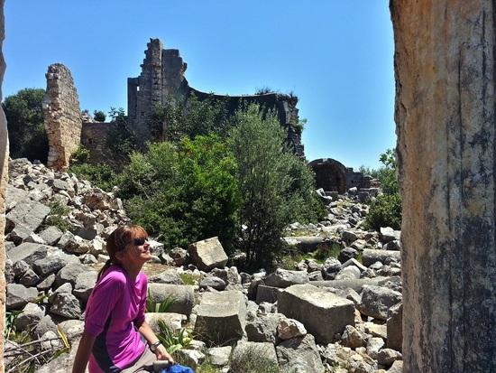
    Four hundred metres on, we came to İmirzili (sometimes spelled Emirzili), which contains the ruins of a couple of impressive churches (there may be a third, but we didn’t see it).

    Izmirli church

    There is also a Byzantine tower house and a 3rd century Hellenistic watchtower, with phallic carving.

    Izmirli tower

    A very stony tractor track led us back parallel to the way we’d come towards the sinkhole. The sharp stones made painful walking late in the day and although it wasn’t far, we were glad to reach the sinkhole. I was impressed, Bozena, my wife, less so.

    hole

    Rather than walk back along the painful track, we took a risk on a goat track heading roughly in the direction of Poşlu, and managed to follow it all the way back to the mosque.
    We had an easy walk down the dirt road took us to the ancient road into Çatıören .

    Catioren road

    From there we retraced our steps, sometimes with surprising difficulty considering we’d walked up the same route just that morning. Everything looks very different in reverse.
    When we reached the terracing above Kabaçam, we chose a nice flat terrace with a fine view of the sea and set up camp.

    Camp 3a

    DAY FOUR. Distance walked: 8.94 km, altitude gained: 239 m

    Camp 3b

    After the usual early rising, we walked down the terraces to Kabaçam.

    Kabacam terraces

    We spent some time exploring the area of Hellenistic to Byzantine ruins we’d missed the day before.

    Kabacam 3

    Kabacam 4

    Kabacam 5

    We followed the dirt road down past a herder’s camp. The area around it strewn with an incredible amount of rubbish (not all herder camps are like this), which made it a little ironic that were carrying out our little bag of rubbish from the previous evening.
    Soon, we had to continue east across open land and across a gulley towards the historical site of Kanlıdivane (ancient Kanytelis). As the path descended into the gulley, it became cobbled with small stones. It was different in character from the roads we’d been following on the previous couple of days and more similar to the Ottoman mule tracks we’ve come across elsewhere on the coast.

    Kanlidivane mule track

    It led across the bottom of the gulley and up into Kanlıdivane’s western necropolis, where there are Roman rock-cut figures and tombs in the cliff.

    Kanlidivane western necropolis

    A narrow path took us through fields of high grass to the main site, where a Hellenistic tower and four large churches are built around a limestone chasm.

    Kanlidivane

    A tarmacked road took us down to the coast road and transport back to Antakya.

    #1987576
    Kattt
    BPL Member

    @kattt

    Thanks for the report and the beautiful pictures. What an interesting place to explore!
    As far as other trip reports, the only reports that one should never, ever compare theirs with…..are Eugene Smith's :).

    Thanks for posting this. Looking forwards to more in the future.

    #1988188
    Ken Thompson
    BPL Member

    @here

    Locale: Right there

    Fantastic. Looks like you had it all. Nice weather, not crowded, some great history. Really good stuff. Thanks! +1

    #1988195
    John Taylorson
    Spectator

    @heyjt

    Locale: SoCal

    Nice report! Talking about a hike through history… Excellent photos and reporting.

    –jt

    #1988202
    David W.
    BPL Member

    @davidpcvsamoa

    Locale: East Bay, CA

    What an epic trip! I can only imagine what it must have been like to hike among such history. I recently stumbled on rifle in the Sierra that was about 150 years old and wondered what human events had occurred where I stood. The Roman ruins takes it to another level. Thank you for sharing your report and pictures which were excellent.

    #1988234
    Roger Caffin
    BPL Member

    @rcaffin

    Locale: Wollemi & Kosciusko NPs, Europe

    Utterly unreal.
    And the tourist coaches have not got there yet.
    Lucky you!

    Cheers

    #1988262
    William Chilton
    BPL Member

    @williamc3

    Locale: Antakya

    Thanks to everybody for their kind words. It’s so encouraging to get feedback. I really enjoy other people’s trip reports and really must follow your example.
    Kat, my wife and I are taking an indefinite break from work in order to have more time for hiking, and I should also have more time for writing trip reports. Turkey is a very varied country for hiking.
    Ken, hiking is a very minor sport here. Apart from on the Lycian Way and a few routes in the Aladaglar and Kackar mountains, you are very unlikely to come across other hikers. We walked 5 days of the Saint Paul Trail last summer and saw no one hiking. Plenty of shepherds, though.
    John and David, I considered calling the report “A walk through time” but chickened out.
    Roger, 20 years ago, this area of coastline was almost completely free of development. We used to camp out next to a little restaurant near hear on the shoreline and they’d charge a token fee for using their facilities. Now it’s all ribbon development (but local tourism, not international) nearly all the way along this section of coast, but it’s literally 30 metres deep – beyond that you’re in the bush, so to speak. And nobody leaves their swimming pools or the beach; the ruins at Korykos in some of these photos are 500 metres from the largest resort along this stretch, but no visitors!

    #1988399
    Tony Wong
    BPL Member

    @valshar

    Locale: San Francisco Bay Area

    William,

    I love the ancient world and it is a treat to see that part of the world.

    Must have been amazing to be able to stand before ancient history like that.

    How did you find traveling to Turkey?

    Safe/hassle free given the political tormoil in the region that is adjacent to Turkey?

    Thank you for sharing your trip with us.

    Definitely unique for sure.

    -Tony

    #1989039
    Ian
    BPL Member

    @10-7

    William,

    What a wonderful adventure! I've always wanted to visit Turkey and it's nice to see the backpacking possibilities.

    #1989727
    Tom Clark
    BPL Member

    @tomclark

    Locale: East Coast

    William,
    Awful trip report…Wonder adventure! ;)

    Thanks for sharing such a non-traditional trip report from some place I've never been to, but now have some sense of it.

    Tom

    #1989829
    William Chilton
    BPL Member

    @williamc3

    Locale: Antakya

    Tony, travel in most of Turkey has been unaffected by the problems in Syria. Eastern Turkey has long been affected by the fighting with the PKK, but there are recent signs that things are improving there.
    I live in the Turkish province of Hatay, which is right on the border with Syria and things in this province have been affected by the troubles in Syria. There are a lot of Syrian refugees, both in the camps and in the towns. Hatay has a large Alawite minority (30-40%?), the same sect as Bashar al-Assad so there is tension here, and frequent protest marches against war in Syria.
    Two weeks ago, two car bombs killed 50+ people in Reyhanli, a Hatay town close to the main border crossing to Syria, which has raised tensions even higher.
    However, as I said, most of Turkey has been unaffected.
    Ian, Turkey is waiting for you! There is some good walking here. There are no real wilderness areas in the American sense – anywhere that can be walked to will be grazed by goats, sheep or cows at some point in the year – but there is still some fine above the treeline walking, and very few hikers getting the benefit of it.
    Tom, I'm glad you got something out of the TR, at least. What was the main problem – too many words or the wrong words?

    #1990461
    Edward Z
    BPL Member

    @fuzz

    Locale: Sunny San Diego

    A wonderful writeup! Gives me hope! Great trip and photos. Thanks again!

    #1990498
    Manfred
    BPL Member

    @orienteering

    William,

    Thanks for the great trip report. A trek in Turkey might be in my future. After coming back from Scotland I love all the sun in your photos.
    How feasible is it for foreigners to do a trek — let's say the Lycian Way — without any knowledge of the Turkish language?

    Best Regards,

    Manfred

    #1991693
    William Chilton
    BPL Member

    @williamc3

    Locale: Antakya

    Thanks for the kind words Edward and Manfred.
    "How feasible is it for foreigners to do a trek … without any knowledge of the Turkish language?"
    Shortish answer, I thinks it's quite feasible, especially a walk like the Lycian Way, which passes through an area where a lot of people speak English. Amy Lauterbach could probably tell you more as she's trekked here without the language.
    I've pm-ed you a longer answer.

    #1992230
    Amy Lauterbach
    BPL Member

    @drongobird

    Locale: San Francisco Bay Area

    Manfred – about hiking in Turkey without speaking the language…

    I wrote a bit about it in our trip report about Turkey. See the last section in that report.

    Before the trip, I completed five (out of 30) lessons in Pimsleur's Turkish audio program (available from Palo Alto Library). Because the language is so different from anything I know, I took each lesson about 5 times! I was really glad that I did so. If/when we go back, I will make the effort to take all 30 lessons.

    We have never hiked in a place where the people we met were more gracious and friendly in a proactive way. In other destinations everybody is polite and generally cheerful (except our recent trip to Scotland, in which we encountered 4 locals who were actually rude or hostile). But in Turkey, the locals were tripping over themselves to be generous and friendly. It's possible without any Turkish, but I found it made things a lot more fun and engaging to be able to speak a few basic phrases.

    The fact that you speak German will be helpful. And if you or M speaks some French that will also help. We met quite a few men in their 50s or 60s who had worked in either France or Germany, and therefore spoke one of those languages.

    Also, I had a Turkish-English dictionary with audio (iphone app) that was very handy, as it allowed me to learn new relevant phrases as we travelled, such as "the food is excellent" and "you are very kind".

    And I heartily recommend you and M plan a trip to Turkey. I LOVED that trip.

    #1992232
    Amy Lauterbach
    BPL Member

    @drongobird

    Locale: San Francisco Bay Area

    Great report on a destination most people are not familiar with. Thanks for posting, and please post more. (I'm not sure what Tom found "awful"? Jim thinks he tried to type awesome and his spell corrector fixed his word to awful by mistake. Tom's not the kind of guy who would write something mean-spirited like that.)

    #1992457
    William Chilton
    BPL Member

    @williamc3

    Locale: Antakya

    Thanks for the kind words, Amy. I owe you a big debt of gratitude since it was through your report on your walks in Turkey that I first heard of Openstreetmaps, which has opened up for us areas of Turkey which would otherwise be very difficult. Thanks so much for that.

    #1992466
    Andrew Manies
    Spectator

    @amanies

    Locale: SF Bay Area

    Hi William,

    Thanks for your wonderful trip report and beautiful photographs.

    I hate to change the focus to gear, but it appears that you and your wife are sharing a Hexamid Long. I wonder if you could elaborate on how well it worked for you, whether the room was sufficient, etc, and why you had chosen it over, say, a Hexamid Twin?

    A

    #1992474
    William Chilton
    BPL Member

    @williamc3

    Locale: Antakya

    Hi Andrew,
    We have a Twin as well (in .74 oz cuben). The Long has more space, though it's at the head and feet rather than at the side. If you want to bring your gear inside with you, there's much more space for it in the Long. There is also a lot more clearance above your heads. The person in the back does have to be a little more careful not to touch the wall than in the Twin, but we share a twin quilt (ZPacks) so we're sleeping close together anyway.
    I like both the Twin and the Long. I think the Long looks a little better :)

Viewing 19 posts - 1 through 19 (of 19 total)
  • You must be logged in to reply to this topic.
Forum Posting

A Membership is required to post in the forums. Login or become a member to post in the member forums!

Get the Newsletter

Get our free Handbook and Receive our weekly newsletter to see what's new at Backpacking Light!

Gear Research & Discovery Tools


Loading...