


I know that Kalispell has atleast two more locals that will be representing. Looking forward to meeting everyone.
Topic
Become a member to post in the forums.
I know that Kalispell has atleast two more locals that will be representing. Looking forward to meeting everyone.
I will be coming down from Calgary on Friday afternoon/evening. Is there a car shuttle planned? Or others who want to share a ride?

Nice to hear you're coming down.
There's been a little chatter on shuttles but nothing concrete so far. It seems like there's quite a few people who'll be wanting rides. With the event 4 weeks away, this will hopefully take shape soon.

Here's the deal on rides from the finish (parking lot @ Bear Creek) to the start at Benchmark.
Hopefully those who were going to contact Cyrus about this have already done so.
If you're still looking for a ride, you'll need to email dave at backpackinglight dot com by the end of this week. If there is more interest than will fit in my car (which seems highly likely) I'll be looking into renting a minivan, which should seat six plus myself and the driver. I'll take the first six names I get and ask for paypal or a check to secure your spot. The amount will cover the cost of a rental for 24 hours and gas, so somewhere between 20 and 30 a person. After a notification email goes out at the beginning of next week the first six will have a day or two to commit, after which time I'll move down the list (if there is one).
Pickup time at Bear Creek will depend on who is the shuttle driver and when that person (and I) can get off work. Around 5pm Friday is a safe bet for planning purposes. If there are Flathead folks who want in we can work out a meeting spot in the valley.
So, you have this week to speak up and commit.
In spite of what seemed like an earlier than usual melt off, snow conditions across elevations are more or less where they were last year. Mid elevations are probably a bit thinner. As usual, temperatures could do anything in the next three weeks and cause drastic changes, or little change at all.
My wife and I have altered our plans a little and plan to fly into and out of Great Falls. We will be renting a car in Great Falls on Thursday the 24th, driving to the Bear Creek TH on Friday with an anticipated arrival time of around noon. We plan on getting a car large enough to give two other people a ride, one spot of which has already been spoken for. We don't plan on leaving the Bear Creek TH area until after Dan gets down from the Thunder Bay area. Hopefully if we take Dan and one more person we can eliminate the need for Dave to rent a van and the inherent difficulties that would mean with respect to getting the van back out of Benchmark.
Thanks Greg, I appreciate it.
All emails have been returned at this point, and plans are set. If you're late to the party feel free to contact me, but I can't guarantee anything.
I am finally getting down to looking at potential routes for the first time since November…anyone else sharing their planned route?
Are people following the CDT for first 30km or more? Or even more by swinging east and going 75km or so before joining the Middle Fork?
Is everyone carrying a packraft for the final third of the race??? or walking along the Middle Fork…
Are others planning on veering west of the straight line between the start and finish and considering going over passes etc in the high country on the west side?
Three possibilities depending on condition.
1) base – direct line up and over sun river pass and down the flathead. Roughly 90 miles
2) Chinese Wall Option. Head up the CDT along the Chinese wall then back down to sun river and over the pass. I think that's about 105
3) Super Swami option. Chinese wall option but follow red shale creek back up to the north section of the wall then back down to sun river and over the pass. This is about 120 miles and will require 40mpd.
Two decision points.
1) at start whether to do the Chinese wall option. The only way I won't is if there is sever overcast which would keep me from seeing the wall even if I'm next to it. Or second if there is heavy fresh snow. If I take the Chinese wall option I have to make it across and start back down to red shale creek. I will be targeting a 40 mile day even with the late start. How close I get to that target will dictate the next decision.
2) when I get down to red shale creek I would then decide whether to head back up and go back in the snow. If I take this then my target will be to camp just before the snow.
I have 72 hours to finish the route and make it back to Great Falls. This will factor into the decisions.
Who's next?
Hiking Malto – thanks for sharing.
Question about your "direct"…
Is Sun River Pass located here 47.957514,-112.979622?
This would take you significantly east of the CDT…is that a choice due to snow potential on the CDT?
As near as I can tell without a map this is where I'm planning to cross into the Flathead Basin. This will allow me to wok around to the north east side of the Flathead without crossing it directly. My concern is that not being familiar with the area that I would have to head upstream on the flathead to find a suitable crossing. There are several other options further to the west but all involve a Flathead crossing. maybe that's not a big deal but May 25th is normally close to the peak streamflow.
I don't think there's going to be much packrafting happening on the MF Flathead. There's possibilities, but it's a rowdy river this time of year. If someone is at that skill level it would be a great way to travel, but it's bold water. The main waterways people will float are probably the Sun River and SF Flathead. There's a chance someone will float White River, Spotted Bear, MF Flathead.
Most walkers are likely headed north up the Sun River valley for a long time (to Sun River pass). It's mild, low elevation fast travel with only one low pass and it lets you over the MF Flathead without major trouble. Any foot options west of here require a major river crossing, which can be fun. So likely the west side will be more the domain of the rafters.
Use this website and set the maps to t3 or t4 (USGS topo or similar).
http://www.mappingsupport.com/p/gmap4.php
Thanks for the insights…
The eastern route looks like a 115km walk between 1200m and 1800m elevation.
Snow at 6000ft seems to be disappearing rapidly
http://www.wcc.nrcs.usda.gov/nwcc/site?sitenum=693&state=mt
Question is can the feet handle it and can it be done in 3 days?
Will see how the feet do this week on some 15km marches…
Time to talk turkey.
I'm contemplating several routes, and won't make a decision until a few days before and the river levels sort themselves out. It's gone past 70 the last three days here in town, and predictably the S Fork has gone past 7000 cfs and the Middle Fork is closing in on 10000.
Packrafting down the S Fork Sun, walking the excellent N Fork Sun valley, and floating virtually the whole Middle Fork is the fastest route. The issue is, as Dan says, that if the water is big the M Fork will be a good place to die. I've never floated above Schafer, and will float little if any miles below Schafer if levels are above 5000 cfs. There are at least four places on this stretch where the whole current goes through a spot about 10 feet wide, and two of those are outside the Three Forks and Spruce Park gorges.
Hiking below the Wall and going through upper Spotted Bear is a nice route. It'd be nice to see that again, especially (as Greg said) if the weather is good.
A third option is to head west over Hoadley/Stadler and float Danaher to the S Fork. (Or one could climb W River Pass and drop in lower.) Not possible to do that float too many times. All the options for getting back over to the M Fork drainage make it a bit long, but I have a sympathetic work environment which makes this option awfully tempting.
It seems like everyone is congragating Friday evening, which should make for some high quality prevaricating. For those who haven't been back before, make sure to snag a spot in the South Fork campground, which is right next to the TH at the end of the road. The Benchmark CG is a few miles back towards town. Sites are 6 bucks a night, and we can share. Shouldn't be too crowded, even if the weather is good.
It's a good idea to have a saw in your car, as downed trees on the road are not uncommon. The road is passable to any old vehicle. Unless it snows a ton.
This event is truly incredible. It really forces you to deal with ambiguity and be willing to decide last moment as the conditions become clearer. Here's the latest option that I'm flirting with. instead of doing the full CDT route from start until Sun River Pass there is an option to stay high, leaving the CDT at Open creek and continuing north over switchback pass, past trilobite and gable peaks and hit the middle fork at Schafer.
This route is 12 miles shorter but stays in the 7000' range for an extra 16 miles which will likely involve significantly more snow travel than the option over Sun River Pass. Additionally it would require a Middle Fork crossing near Schafer which looks to be in an area of slower moving water. So is it worth 12 fewer miles to potentially be on the snow an extra 16 miles with a middle fork crossing. Hmmmmm. I love these options. Actually, as I type this the shorter option seems insane unless this melt off continues to accelerate like the last few days.
I, like Dave am leaning toward floating the South Fork of the Sun, then hiking to the headwaters of the Middle Fork of the Flathead. At that point the decision to float or hike or both will depend on water levels.
I am seriously concerned about boating such a high volume river in high water, but I also really want to float it…
As for the camping, I plan to arrive at Benchmark Creek ahead of Friday so i should have no problem grabbing us a couple campsites and procuring some fire wood.
Sounds like a good plan Cyrus, we will not be arriving at Benchmark until maybe 9:00pm and it would be good if a few sites were arranged by then. As previously stated, all routes are weather dependent. Good weather will likely mean a trip over White Pass, down the White River to the SF Flathead to Twin Creek and over the hills to the Middle Fork. I will be rafting. The White river route is the one I took last year. IF the weather is bad and there is little to see I'm inclined to go over Stadler Pass, Danaher to the headwaters of the middle Fork and down. I'll use my Alpaka even though Dave makes a good case for the Scout (I don’t have one). We'll compare tales of who gets the wettest after it's all said and done.
Anytime you put a hundred or more miles on your feet it’s going to hurt; last year did. I’m hoping to split the trip to about 60 miles on foot, 40 miles on river. For general information purposes, last year the snow level in the central range west of Benchmark started at 5900’, by 6100’ snow shoes were really needed. In that case I went over an unnamed pass that was about 7900’ if I recall at the extreme headwaters of the South fork of the White River. There were a number of avalanche chutes along that route but no real danger. Most of the snow I saw slide came off the upper reaches of the surrounding mountains. Of the few I witnessed most stopped sliding well before they reached the valley floor.
Frankly I’m hoping for weather similar to, but not as wind driven intense as last year because the lower temperatures kept the stream levels low. Having said that those are conditions that are out of our hands so route planning that involves more than one path is a good idea.
Lastly, I will have some extra room in the van for gear if things get tight in any of the other cars.
I won't know if I can make it until the week of, but I might as well throw my two cents in. I'm looking at going over Spotted Bear Pass and down Spotted Bear River, cutting up to the MF either at Pentagon or Schafer.
My objective this year are to finish and, secondarily, to absorb some more local knowledge, the idea being that with both of those in hand I'm positioned for bolder route attempts in the future. But this year is about a finish, a conservative goal that, combined with solo travel, lends itself to a conservative route.
So, I'm looking forward to returning to the familiar and striking Sun River basin (my bail route last year) but on the west side of the river this time. Cross at the bridge near Gates Park and then over Sun River Pass. Some tributary crossings after that, than I'm out.
96 miles if I added right. I could probably cover the distance in three days without obstacles (but with sleep), plan to take four, and will bring food for five. I'll be carrying overnight gear. Incidently, I just finished the new book about Dick Griffith and discovered that we both share a liking for sleeping well each night. Sustainable pace is my strategy here.
I hope everyone already noticed that all three forks of the Flathead are setting flow records as we speak. I drove past the Bear Creek TH yesterday afternoon, and must report that it was an impressive and terrifying sight.
So Dave, How does that rank on the PR difficulty scale?
Has me wondering how wet the trails will be and how much of them could be underwater…
Yep, been watching that. In-flow at Twin Creeks is now over 20,100cfs, aka 13 feet deep. Also have to notice that this is after a weekend of upper 80's. The long range forecast through mid this week, and into late next week, is for highs about 2o degrees cooler and for cooler nights. As I recall it did this last year also about this time and then settled down for the second half of May, I see something similar setting up now. The long range weather patterns do not; however, seem to suggest a major spring storm is on the way like last year. Nevertheless it looks like some dicey stream crossings could be in the offering.
"So Dave, How does that rank on the PR difficulty scale?"
I'll just say that my plan had been to float down the Essex, use the Isaak Waltons phone, and drink a beer while waiting for a ride home. There's no effin way I'd packraft the Bear Creek to Essex stretch right now.
Dave, any pictures of the middle fork?
Since all the snow has melted off the trail, there isn't enough challenge in the hike. Now thinking that a ride down the middle fork in an inflatable duck could be much quicker. But that's only the backup plan.
I went ahead and put an order in for the weather. I ordered continued melt for the next 6 days with wind and rain followed by a cold snap with temperatures in the lower 30s through our weekend. That will give us low snow and low stream crossings. We will see if my order comes through.
Here's the interesting part of this adventure. The 25k cfs flow now really won't help the flow in two weeks. Right now using the Mt Lockhart data the melt is ten days ahead of median. (It was right in track two weeks ago) so if you assume that the middle fork is also ten days ahead it puts the flow at exactly the maximum median flow rate of 12,200 ft. While we won't have median conditions, it does show that the only real positive will be less miles of snow to walk through. Now we are at the mercy of the temperatures.
As an aside, will bugs be out this early? I know the Sierra goes from snow to bugs overnight, how about here?
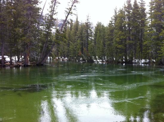
Where's my duckie?
Become a member to post in the forums.
 Vaer C4 Tactical Field SolarDurable timepiece for wilderness users - 20ATM (200m) water resistance, 120-click bezel, 316L SS casing, sapphire glass, solar-powered, Epson VS-42 Japanese movement, C3 Lume, USA assembly.
 © Beartooth Media Group Inc.
 Loading...