Several months ago, there was an interest in Southern California BPL hikers getting together for a trip. Going on a group trip is something I have never done. But in the spirit of the BPL community, I offered to plan a trip that I had done last year. I wanted to limit it to 4 people max.
Craig Wisner “signed up” for the trip right away. No one else from BPL asked to join. Two guys who work with my wife also wanted to go, but at the end, they bailed.
The planned trip was:
Day 1: The desert floor in Palm Springs to the Summit of Mt. San Jacinto, then 1 mile down to Little Round Valley.
Day 2: Little Round Valley to Cedar Springs.
Day 3: Cedar Springs to Palm Springs where we left our vehicles.
The trip was planned in January, but due to a record snowfall, I decided to change it a little bit at the last moment. There was still so much snow on the ground that summiting Mt. San Jacinto might require an ice axe and crampons, extra gear I did not want to carry on such a long trip. So Craig and I agreed to skip the summit, shortening the trip by about 7 miles.
I also was not sure about hiking with someone I did not know personally. It seemed to me that personality could make or break a trip. Also, I am almost twice Craig’s age, and he is in great physical shape, running 50K races as a hobby. My concern was that I would hold him back, possibly causing strife. Lastly, based on posts on BPL, we seemed diametrically opposites in regard to our politics and our view of the world.
But as we kept in contact via email during our planning for several months, I began to feel that he might be a good fit as a hiking partner.
On Saturday May 29 we met at the Palm Springs Art Museum at 4:45 AM. After greetings and such, we hit the trail at 5:00 AM. The planned hike for the day would be to hike up to Long Valley (the area of the Palm Springs Tram), and then on to Wellman Divide for a night camp. Camping in the State San Jacinto Wilderness is only permitted in specific campgrounds, but snow camping is permitted outside of the designated areas.
It was a beautiful morning as we headed up the trail and the sun started to rise. We took our time and we stopped many times as I pointed out geographic points in the Coachella Valley below. The high temperature for Palm Springs was predicted to be in the 90’s, but as we gained altitude we maybe had a high of around 80-85 degrees F.
The hike to Long Valley is 11 miles with an elevation gain of 8,000 feet. This is known as the Desert Skyline Trail. It is not an official trail, and the government agencies and Riverside County Rescue Unit do not like the trail, because the majority of rescues and deaths in the San Jacinto’s occur on this trail. From Long Valley, it is another 3 miles to Wellman Divide, and 2 of those miles would be in snow. This 2nd section is a 1,000-foot elevation gain from the Tram Area. We both wore racing flats, instead of boots or trail runners, and we carried plastic bags, in case we would need waterproofing for our feet in the snow. As it turned out, we never used the plastic bags.
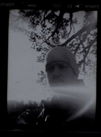
During the strenuous Skyline hike, we had a great time discussing all kinds of topics and getting to know each other. I brought a camera, but was enjoying myself so much, that stopping to take pictures would have been a distraction. So I don’t have many pictures to share. Sometimes a camera becomes a heavy burden for the mind.

The "8 miles to Go Rock"
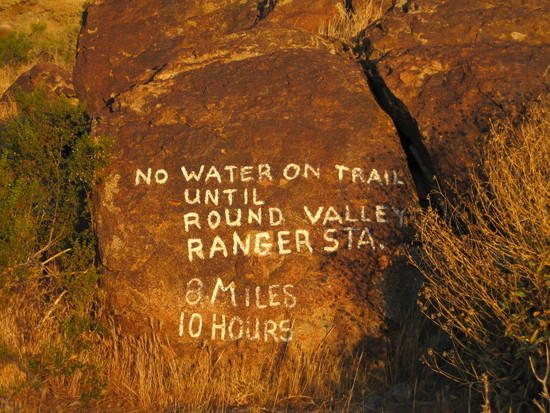
The "No Water Warning Rock"

The "You Might Die Sign"
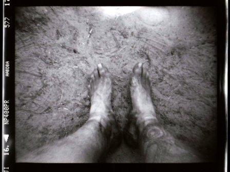
The last mile of the Skyline Trail is STEEP, and I needed to rest several times during this last section to catch my breath. Craig was extremely patient with me, and we made fairly good time, finishing the trail in about 8 hours. At about the 9-mile mark, I landed heavily on a pointed rock, and it felt like I had bruised the ball of my left foot. I mentioned it to Craig, and told him that it was bothering me, and wanted to stop to check it out, once we topped out near the Tram. Craig had forgotten his lip balm, so we agreed to take a break below the Tram station. I would check out my injury, and Craig would hike up to the Tram Station and purchase some balm. As we walked, it felt like I might have damaged the sole of my shoe, and it could have cracked open, causing the split to pinch my foot. Once we got near the Tram, I stopped at the Ranger Station to refill one of my water bottles. I had finished the last of my 4 liters when we got to the Tram Area. So while Craig was getting his balm, I inspected the shoe, and it was okay. I figured it was just a bruise, and did not look at my foot. Craig filled one bottle with water, as we would fill the rest of them at Round Valley, which would be about a mile from the area we would stop for the night.
About a mile from Long Valley, most of the trail was covered with snow all the way to Round Valley. We stopped in Round Valley to fill our water bottles for dinner, breakfast and drinking water for the next morning. Craig added drops to his and I used tablets. The water was ice cold, coming out of a piped spring. While we stopped, two groups of hikers arrived, all carrying humongous packs.
We now had one mile to go, with a 500-foot elevation gain. No trail, all snow. At the top, in a saddle, we found a wonderful dry campsite among all the snow, tucked inside a ring of boulders and surrounded by trees. Day one was now completed, 14 miles of some very hard hiking, gaining 9,000 feet in elevation. The sun beamed down on us until it set, and surprisingly also beamed down on us in the morning when we got up. We quickly set up camp and cooked dinner. I had a Mountain House Spaghetti dinner, and was jealous of Craig’s Ramon noodles with fresh spinach and mushrooms. We celebrated the first day with a little whiskey Craig provided. During the night, the wind probably dropped the temperature down into the 30F’s but were we warm and comfy. Craig in his Western Mountaineering SummerLite, and me in my Nunatak Arc Specialist. During the night we were entertained by a full moon and of course a star filled sky. We slept on plastic sheets and pads. No shelter to hide our view of the world.
Craig is a get up and go without breakfast kind of guy, preferring to eat cold food on the go. But he was fine waiting for me to cook my oatmeal and coffee for breakfast. We both have a similar backpacking styles, and can pack up and leave in the morning in a matter of minutes. Before we left, I inspected my left foot, and the entire ball of my foot was one huge blister. Craig used to be an EMT, and is very knowledgeable. We determined it was not a friction blister, but caused by trauma, and had grown during the previous day’s impact and continued hiking. Since the blister was into the folds of my toes, I felt it was best to leave it and not lance it. So we hit the trail.
It took a few minutes to traverse some snow and boulders to find the trail down through Wellman Cienega and it was snow free for maybe ½ mile. But as we descended the route became all snow for about a mile or more. Our racing flats worked perfect, and Craig led the way kicking steps in the steep sections. The coolness of the snow soothed my foot, and I was able to keep a steady pace. We met a few hikers along the trail.

Craig finding the trail and leading the way.

Umm… where's the trail?

Somewhere down there is Saddle Junction.
Once we got near Saddle Junction (3 miles into our hike), we saw the largest pack I have ever seen, and strapped to the top was a huge bag of dog food. The owner was not around. There was no snow at Saddle Junction (8,500 feet).
As we hiked a wide trail side-by-side, we resolved most of the world’s problems, and we missed our junction. My fault. I have been on this trail many times. When I finally realized we probably were on the wrong trail, and we turned around, it was a 6-mile round trip mistake!! So we turned around and headed back. I felt so bad, and kept apologizing, but Craig would hear nothing of the kind. On the way back, we passed the owner of the huge pack with dog food and his SAINT BERNARD dog. Wow, what a huge animal.
We got to a meadow in Little Tahquitz Valley around noon, and filled our water bottles, as it would be 15 miles to our next water source, and would be hiking many miles in the hot sun, when we dropped down to the Desert Divide section of the PCT. We had done 9 miles in 5 hours, including a slow-down over the snow.
As we headed out, we soon encountered several miles of no trail but snow, some of it up to 4 feet deep, and at only 8,000 feet elevation. Craig again led the way, and set the pace, kicking steps where we needed them on the steeper slopes. We finally cleared the snow and started down towards the Desert Divide and dry trail. My foot started to hurt, and we stopped for water, a check of the map, and a plan for the rest of the day. If I could not make it to Cedar Spring, we could take a one-mile detour to Apache Spring for water. But we would have enough water even if we had to camp before our next source. I felt I could make all the way to Cedar Spring, but knowing the trail, told Craig we might not get there until 8 or 9 PM. So, that being resolved, we enjoyed the view of South Peak, Spliter Peak, Anstell Rock and Apache peak; while snacking on Cliff Bars, junk food and enjoying our cold water. Most PCT hikers do this section from south to north, and often do not get to appreciate the view we would have for the few hours.
While we were soaking in the view, a group of hikers approached. The last hiker was Glen from Gossamer Gear. I had met him a year ago on the same trail. Amazingly, he recognized me and even remembered my name. The guy must have a photographic memory. After a brief conversation of trail conditions they were heading towards, Craig and I got up and resumed our hike. Even with my sore foot, I was able to go non-stop with an occasional stop for water and a snack. We had a wonderful time, other than the parts of the trail on the east side of the divide that are high desert and the sun that beat down on us. Amazingly, we would hike in high desert for a while, then traverse up to pine trees; over and over.
Once we passed the Apache Spring turn-off, we descended towards Fobes Saddle, a trail section that is mostly shade. We got to the Saddle around 6 PM, and my foot was rather sore, but not enough to stop me. I know the blister had popped, as there was no longer a hump on the ball of my foot. At Fobes Saddle, we met a couple of guys with large packs, who were setting up camp in the scrub oak clearing that is often used as a cache on the PCT. They were on a multi-day trip, with conventional heavy gear. Of course a talk about equipment ensued, and they were in disbelief when we told them each of our complete kits weighed less than one of their empty packs. I let one of them lift my pack, and then shocked them when we told them we were going on to Cedar Springs (5 miles away) that day. We quickly climbed the seemingly endless switchbacks out of the saddle, leaving the desert for a cool pine forest high above the desert to the west, and Garner Valley to the east. We saw some people stealth camping in the forest, as we approached the ridgeline of a manzanita forest. This section of the trail is mostly rocks, and I slowed as I tried to avoid as many rocks and stones as possible. We soon got to the Cedar Spring turn off, and descended the mile down to the spring. It is amazing that we were dropping down in elevation from high desert and into a lush forest of incense cedar. It was now 9:00 PM. I was almost out of water, and while Craig set up his site for the night, I filled my water bottles. For dinner I had one my favorites, Mountain House Lasagna with meat sauce. But what really looked good was the bean burrito Craig built for himself. We chatted for a while, and contemplated what our mileage for the day was. It was 26.5, as I determined later from the mileage markers on our Harrison Map. It was much warmer than the previous night, as our camp was at 6,400 feet elevation, more than 3,000 feet lower than the first night’s camp.
The next morning was a quick cup of coffee, and a couple of Cliff bars. Craig filled his bottles at the spring, and we started the last leg at 6:30 AM, which would be a 12.7 mile hike, and a 5,500 foot elevation drop. As we crossed Garnet Ridge into the West Fork of Palm Canyon, the temperature rose quickly. Traveling with no shade at all, the temperature was right around 100F when we arrived at the Agua Caliente Indian Trading post at around 11:30 AM. Craig got the Coca Cola he had been craving for 3 days, and I feasted on a Popsicle. From there we hiked about 4 miles in the heat of the day. Once we got into the business section of Palm Springs, we decided to take a bus the last two miles. No use hiking through the city, and Craig had a 100 mile drive back home, with the possibility of holiday traffic. The bus had a much-welcomed air conditioning system, and we were quickly near the starting point of our hike. Craig treated me to a Starbucks Frappacino, and we hiked the last two blocks to our vehicles. And that was our Excellent Adventure, with an Excellent Hiking Partner.
Nick’s gear list:
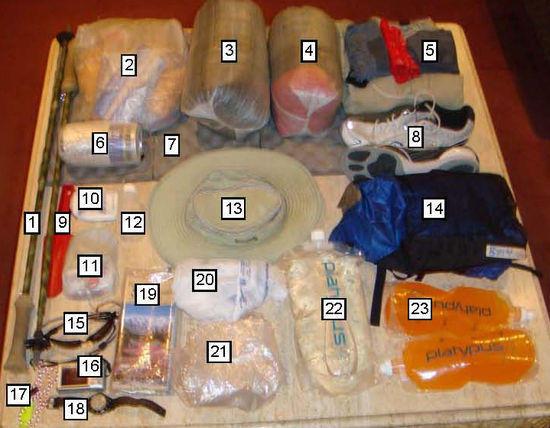
1. GG LT4 Trekking Poles
2. Food
3. Quilt
4. Spare clothes
5. Worn Cloths
6. Caldera Cone, Stove, Lexan Spoon
7. GG NightLight Torso Pad
8. Saucony Shay Racing Flats
9. Trowel (required by regulations
10. First Aid Kit
11. Personal Items Kit
12. Fuel Bottle
13. Tilley Hat
14. GG Murmur Pack
15. Maui Jim Bifocal Sunglasses
16. Camera
17. Micro Light and Whistle
18. Timex Watch
19. Map
20. Plastic Bag Water Socks
21. GG Polycro Ground Sheet
22. 2 L Platy
23. 1 L Platy (2 ea)
Pack Base Weight: 3 lbs 14.8 oz
Consumables: 12 lbs 7.3 oz
Pack Weight (Total): 16 lbs 6.0 oz
Worn: 3 lbs 8.4 oz
Total (FSO): 19l bs 14.4 oz
Itemized Gear List
BASE ITEMS
Backpacking Light UL 60 Balaclava 1.9 oz
Cuben Sack for Down Jacket, glvoes, baclava 0.2 oz
Montbell Extremely Light Down Jacket 6.1 oz
Montbell U.L. Windpants 2.3 oz
Montbell U.L. Windshirt 2.7 oz
Plastic Bags for feet in wet snow 0.4 oz
Smartwool Merino Wool Glove Liners 1.5 oz
Smartwool Socks 2.7 oz
Caldera Cone, Stove, & F Keg (complete w fuel bottle) 3.8 oz
Cuben Food Sack 0.3 oz
Lexan Spoon 0.3 oz
Nalgene Coffee Conatiner 0.5 oz
Platypus 1 liter water sack 1.8 oz
Platypus 2 liter water sack 1.3 oz
Map 3.0 oz
Gossamer Gear Murmur Pack (w/o foam in straps & mods) 6.8 oz
Cuben Sack for Quilt 0.2 oz
Gossamer Gear NightLight foam pad (torso length) 4.5 oz
Gossamer Gear Polycryo Ground Cloth (40" X 96") 1.7 oz
Nunatak Arc Specialist (Med/.8oz Pertex Quantum) 15.0 oz
Driver License, ATM Card, Cash 0.4 oz
First Aid Kit: 1st Aid Ointment (2 ea) .1 oz
First Aid Kit: 1st Aid Towelettes 0.1 oz
First Aid Kit: 2" X 2" gauze (2 ea) 0.1 oz
First Aid Kit: Cuben sack 0.1 oz
First Aid Kit: Leuko Tape 0.1 oz
First Aid Kit: Medium Bandaids (4 ea) 0.2 oz
First Aid Kit: vial w/7 Advil 0.3 oz
Personal Kit: 12 micropur tablets 0.3 oz
Personal Kit: Cuben sack 0.1 oz
Personal Kit: Derma-Safe folding knife 0.3 oz
Personal Kit: Dr. Bronner's soap in mini-dropper bottle 0.4 oz
Personal Kit: Duct Tape 0.3 oz
Personal Kit: Finger Toothbrush 0.05 oz
Personal Kit: mini BIC Lighter 0.3 oz
Personal Kit: Thread, needle, etc. 0.1 oz
Personal Kit: Toilet paper (blue shop towels) 0.4 oz
Trowel – plastic (required by regulations) 2.0 oz
CONSUMABLE ITEMS
Alcohol Fuel 4.0 oz
Beef Jerky 2.5 oz
Cliff Bars 2.5 oz
Fig Newton Cookies 11.3 oz
Goldfish Crackers 6.5 oz
Gorp 15.4 oz
Instant Coffee 0.4 oz
Mountain House Lasagna (repackaged) 5.2 oz
Mountain House Spaghetti & Meat Sauce (repackaged) 4.8 oz
Oatmeal (2 breakfast @ 2 packets ea; repackaged) 6.7 oz
Power Bars 11.9 oz
Water (4 liters) 136 oz
WORN OR CARRIED
Ex Officio Boxer Briefs 2.6 oz
Rail Riders Eco Mesh shirt (L) 7.5 oz
RailRiders EcoMesh Pants (M) 12.0 oz
Saucony Shay XC Flats 14.4 oz
Tilley AirFlow Hat 3.6 oz
Wright Socks 1.6 oz
Bandana 0.9 oz
Book of matches 0.1 oz
Cannon SD1200 IS Digital Camera (carried in shirt pocket) 4.9 oz
Fox 40 micro whistle (on Spectra cord lanyard) 0.2 oz
Gossamer Gear LightTrek 4 Trekking Poles (pr) 6.8 oz
Maui Jim Ho‘okipa MauiReaders Sunglasses 0.6 oz
Timex Expedition Watch 1.2 oz