Topic

Goose Creek TH Loop, Lost Creek, CO


Forum Posting

A Membership is required to post in the forums. Login or become a member to post in the member forums!

Home Forums Campfire Member Trip Reports Goose Creek TH Loop, Lost Creek, CO

  • This topic is empty.
Viewing 25 posts - 1 through 25 (of 27 total)
  • Author
    Posts
  • #1236362
    James Dubendorf
    Spectator

    @dubendorf

    Locale: CO, UT, MA, ME, NH, VT

    Hello All,

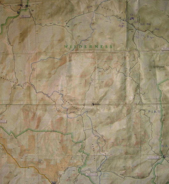
    Given the recent interest on BPL in the Lost Creek Wilderness, part of Colorado's Pike National Forest, I thought I would report on a 35+ mile (officially speaking), 5500 +- elevation gain, loop from Goose Creek Trailhead I enjoyed earlier this week. The TH, at about 8200', is in the southeast portion of the Wilderness (Kenosha and Tarryall ranges), and roughly the northwestern edge of the infamous Hayman Burn. Seven years ago, this wildfire consumed 138000 acres over 3 weeks, the worst in Colorado history. It was started by a forest service employee who claimed they caused the blaze by burning a letter. Signs of the fire remain, and extensive remediation efforts are ongoing, as erosion threatens watersheds that are crucial for Denver.

    There are several variations on the loop. I hiked clockwise: Hankins Pass, Lake Park, Brookside McCurdy, Wigwam, and Goose Creek Trails. Having now hiked in both directions, counterclockwise seems to introduce elevation at a more, ahem, forgiving rate. My plan was to complete the trip in an overnight. I experienced some embarassing navigational circumstances, however, that resulted in a second night out. Given my extra food, the only harm done was to my pride. Conditions were excellent: nights around freezing, no precipitation until the last few hours of the trip (it started hail and lighting as I got to the car!), and days in the 60s (?), moderate sun, with plenty of wind in the higher elevations.

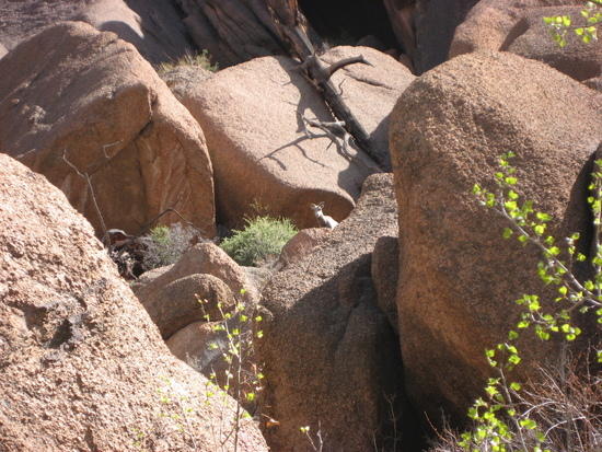
    The Hankins Pass Trail heads west up Hankins Gulch along an eminently pleasant stream. Stands of pine and aspen untouched by the fire are interspersed by areas in the early stages of recovery. One benefit, if you can call it that, is that some pretty cool rock formations are exposed.

    Hankins Gulch

    Burned Pine

    Hankins Gulch II

    Hankins Gulch III

    From Hankins Pass, the Lake Park Trail takes you north through, of all places, Lake Park. The park:

    Lake Park

    Here is a shot above the park from the previous trip in June 2007. Soon after it was taken, a violent hail, rain, and lightning storm descended on us.

    Lake Park Trail June '07

    View from Lake Park Trail

    The Lake Park Trail tops out at about 11800', and on this ascent is where I encountered the only significant snow accumulation on the trip. You can see some hint of snow in the above picture. Lots of snowbanks and postholing, which I finally managed to escape by heading west over the ridge, and then following a transect NW to meet up with the McCurdy Trail.

    The intersection of the McCurdy and Brookside McCurdy Trails in, yes, McCurdy Park, is down at about 10700', but this is only to prepare you for an ascent that will top out at 11900' near Bison Peak, 12431' (28th highest peak in CO wilderness areas), the high point of the loop.

    This is a view towards the summit of McCurdy Mountain. I'm guessing humility was not one of this McCurdy guy's strongpoints.

    McCurdy Mountain

    The Brookside McCurdy Trail, while not exactly beside a brook, is a wonderful, stark high alpine stretch.

    Brookside McCurdy

    Brookside McCurdy II

    A view of Pikes Peak, 14110', to the southeast.

    Pikes Peak

    A comparison with another shot from the previous trip. What a difference a month makes…

    For Comparison, May 2009

    Flanks of McCurdy Mountain

    I'll continue with more of the older pictures. This trip over Bison Peak was extremely windy, and I was in much more of a hurry this time around…

    Bison Peak from a Distance

    Bison Peak

    A new shot for comparison…

    Bison Peak May 2009

    Last trip, we enjoyed a calm sunset on the summit.

    Rock Formations on Bison

    Looking NW from Bison

    Stone Person

    Sunset Colors

    From Bison Pass, the Brookside McCurdy Trail heads north towards Lost Park Campground. It follows the marshy areas in the center of this picture. The Kenosha, and beyond, Platte River ranges are in the background.

    From Bison Towards Lost Park

    What a nice section along Indian Creek, looking north.

    Looking North Along Indian Creek

    I camped a little ways past Lost Park Campground along the Wigwam Trail. First day about 18 miles. A view in morning from near my campsite.

    Western Edge of East Lost Park, Lost Creek

    The Wigwam Trail heads in an easterly direction from about 9900' at Lost Park Campground, down to around 9700' through the beautiful Lost Park.

    Lost Park

    Perhaps this was an omen of things to come…

    Bad Omen

    A herd of elk in Lost Park.

    Elk

    This is where things get…embarassing. I should have had about 17 miles to go before returning to Goose Creek TH. Here is where that omen comes in. Much more than 17 miles were in store. I was walking along, enjoying the morning, stirred by morning coffee, proud of my good foot health, and feeling like the remaining 17 miles were going to be a breeze. In my bliss, I headed south along a trail, marked but unnamed on the map and very distinct on the landscape, only about halfway between my campsite and the southerly trail I was SUPPOSED to take. Did this new trail look familiar? Of course not. But on the previous trip, I was struggling with blisteritis, and thought it might have blurred my memory. What about the map? Well, there were just enough superficial resemblances to get me into trouble. I should have noticed all the many discrepancies, of course, obvious to anyone who can tell a highway from a countour line, but I was blissful. The morning was young and full of promise. The scenery was intoxicating.

    Intoxicating Scenery

    So, off I went towards McCurdy Creek. This is what I look like with no idea I am not where I am supposed to be.

    Blissful and Unawares

    I did see many beautiful sights.

    McCurdy Creek

    Nest

    It did not take me long to realize something was wrong. My fundamental mistake, however, was failing to realize my originary mistake- the one that set all this in motion. What I thought were mistakes were actually merely the symptoms of my primary error (leaving the Wigwam Trail too early). So, as long as I didn't realize the nature of my problem, no solution was possible. At one point, I was able to visually verify where I had left the Wigwam Trail and get my bearing from that point- BUT the point that was supposed to be my certain referent was, unbeknownest to me, not the point I thought it was. So I scrambled, I bushwacked, I struggled to make sense of the map (of course there was a reason nothing quite matched)- I even found well traveled trails with cairns, tree maintenance, the works.

    I once read a quote on navigation at sea, something to the effect of, when the chart and reality don't match, follow reality…yea. Well, I spent an unplanned night on the banks of McCurdy Creek (did this guy have to name EVERYTHING?!), in a beautiful clearing with a nice bench and firepit, and then returned to the Wigwam Trail the next morning once the mystery was solved. Fortunately, I had an extra day of food as a precaution, so I was never in any discomfort, water was plentiful, etc. However, if I had been injured or worse, prospects of rescue would have been dimished by the fact that I was so far off route.

    So, after two nights out instead of one, I finished my trip with a severly bruised ego. In some sense, I suppose I should be glad I learned valuable lessons about operating alone in the wilderness under somewhat forgiving circumstances. I certainly improved my navigation skills by leaps and bounds, even as my situation was a result of faulty navigation. Anyhow, perhaps telling the story will help someone else avoid a similar situation someday.

    The rest of the loop really is marvelous, but picture taking fell low on my list of priorities. Here is a comparison of a set of beaver ponds along Wigwam Creek about a month apart, May 2009 and June 2007. In fact, almost to the day!

    May 2009

    June 2007

    Once I get a chance, I will post some shots of the Goose Creek Trail from my previous trip. Truly one of the great Colorado hikes, and best to do it when you aren't rushing to beat nightfall and avoid the weather. Here is a shot of the peaks as I was leaving- raining on me, snowing on them.

    Snow

    Oh, and if you get a chance, do check out McCurdy Creek…as long as you are sure it is indeed McCurdy Creek. Nice place that is.

    Thanks for reading.

    James

    #1501718
    Tony Fleming
    BPL Member

    @tonyfleming

    Locale: Midwest

    Hi James,

    Thanks for the Pics, they answer a lot of questions. Looks like you had a great trip.

    Tony

    #1501726
    Dondo .
    BPL Member

    @dondo

    Locale: Colorado Rockies

    It looks like you had a great trip, James. I'm looking forward to seeing the rest of your photos.

    #1501729
    Dondo .
    BPL Member

    @dondo

    Locale: Colorado Rockies

    I think the loop will be in great shape for your trip next weekend, Tony. The lingering snow on your loop will be mostly above Lake Park, as James mentions in his post. We're looking at a week of warm, sunny weather so there will enough snow melting to make that section fairly easy to get through.

    #1501735
    James Dubendorf
    Spectator

    @dubendorf

    Locale: CO, UT, MA, ME, NH, VT

    Yep, as Dondo said, this loop melts relatively early in the season. The only place where snow becomes an issue is above Lake Park, though this may melt soon given a warm spell. If you feel confident leaving the trail, some snow can be avoided by heading up slope and cresting the ridge to the west of the trail, then heading down the other side.

    James

    #1501738
    James Dubendorf
    Spectator

    @dubendorf

    Locale: CO, UT, MA, ME, NH, VT

    Oh, and for those who are interested, here is a map of the loop- hope the resolution comes out ok…Disregard my random scribbling.

    MAP

    #1501749
    Eugene Smith
    BPL Member

    @eugeneius

    Locale: Nuevo Mexico

    Great report. I thoroughly enjoyed the comparison/ contrast photos from year to year, it is amazing what nature can accomplish in a mere 4 weeks. I was surprised at the lack of snow in your photographs for May in CO, I always assumed most alpine regions were locked in snow until mid June up there. Looking forward to more reports.

    #1501825
    James Dubendorf
    Spectator

    @dubendorf

    Locale: CO, UT, MA, ME, NH, VT

    Thanks Eugene. Yea, much of the high country in CO is still snowed in, especially north facing slopes, but the Lost Creek area thaws early in the season- lots of southern exposure, and the trail stays between 9000'-105000' most of the time (although even Bison Peak at 12431' was only spotted with snowbanks).

    James

    #1502162
    Jens Aarnaes
    BPL Member

    @finnmark

    Locale: Rocky Mountains

    This past weekend I completed this loop and had a fantastic trip. The weather mostly cooperated though I did get significant rain and hail on Friday night. I did see some snow in places but these were easily avoided – That is until I got on the trail from McCurdy Park to Lake Park. Here, the trail traverses a ridge which ascends from approximately 10k' to 11k' and on the most Northerly slopes the post-holing became exhausting. On top of this, the trail was difficult to maintain as the "splashes" were not always placed as expected. The good news is I have now created a clear path through the snow so anyone following before it melts shouldn't have a problem finding the right way.

    All in all this was a GREAT TRIP and I thank all the posters on this site that motivated me to take it.

    — Jens

    In case anyone is interested, I have posted more details and photos on my blog: http://jenspeteraarnaes.blogspot.com/

    #1502198
    Dondo .
    BPL Member

    @dondo

    Locale: Colorado Rockies

    >>The good news is I have now created a clear path through the snow so anyone following before it melts shouldn't have a problem finding the right way.

    Thanks, Jens. I was hoping someone would break trail for me. ;-) Just read your blog and had to laugh at your description of the climb up to the ridge above Lake Park. It closely mirrors my own experience there.

    BTW, what tent is that in the last photo?

    #1502213
    Jens Aarnaes
    BPL Member

    @finnmark

    Locale: Rocky Mountains

    Hi Dondo

    The tent is a Sierra Designs LightYear. I used a bivy sack for a few seasons until once getting caught in a long storm. The day I returned from that trip I put the bivy sack on the market and bought the LightYear. It is a fine tent for my purposes, by the way.

    — Jens

    #1502217
    Dondo .
    BPL Member

    @dondo

    Locale: Colorado Rockies

    I know what your mean, Jens. Although I sometimes use a tarp or bivy plus tarp, there's nothing like the comfort of a double wall tent.

    #1502350
    Aaron Wallace
    BPL Member

    @basilbop

    James–

    Great writeup! It brought back memories of several childhood hikes I did in the area with my father…

    As for your navigational side-trip, if I recall, the old (1970's?) McCurdy Mountain topo had a trail that followed Lost Creek from East Lost Park to Refrigerator Gulch. By the 80's it was not present on the McCurdy Mountain quad, although the segment on the Windy Peak quad seems to still be mapped. I'm wondering if you accidentally followed this old trail southward. In the early '80's, the segment near Refrigerator Gulch was still identifyable on the south side of Refrigerator Gulch Creek between the present trail crossing and Lost Creek, where there is a beautiful creekside "beach" where Lost Creek emerges from the rocks.

    #1502353
    James Dubendorf
    Spectator

    @dubendorf

    Locale: CO, UT, MA, ME, NH, VT

    Aaron,

    Very interesting! My Nat Geo topo map does indicate a trail following Lost Creek south from East Lost Park (this is indeed what I took), but the trail is unnamed and formally unmaintained. On the map, it terminates just before the intersection with McCurdy Creek. But I can tell you that it is still fairly well maintained (complete with cairns, log bridges, and in places cleared limbs with a saw), and continues east from the intersection of Lost Creek and McCurdy Creek, for a while in a level, marshy area, almost all the way to Refrigerator Gulch. I now realize I was very, very close to the trail in the gulch (just north of it), but the creek disappeared into rocks in a very narrow canyon, and I was not prepared to follow on my own. Also I wasn't alone…

    Above Lost Creek

    This area is well worth the trip, and I imagine with some climbing and wading one could follow through all the way to Refrigerator Gulch. Another interesting option would be to bushwack from near the summit of Bison down to McCurdy Creek.

    Perhaps it is anglers who continue to put so much effort into trail maintenance in this area?

    James

    #1621388
    david nitsch
    Member

    @mangoboy

    I just got back from a 4 day loop through Lost Creek Wilderness. My daughter and I were (pick one: saddened/enraged/disgusted) that the USFS still allows cattle grazing in Lost Park and East Lost Park- IN the Wilderness. How many ranchers (probably few) pay how much (probably next to nothing) to allow their stupid cows to p**p and pillage such a beautiful place, while the Forest Disservice signs are all about LNT?

    If you love Lost Creek like I do, call the South Park Ranger District of the Pike National Forest at 719-836-2031 and SCREAM bloody murder. This is not what Congress had in mind in 1980- perhaps 1880.

    #1624500
    Tom Clark
    BPL Member

    @tomclark

    Locale: East Coast

    James,
    Occasional reminders like "choose reality over the map" are great tips that we can never hear too often. These trip reports are equal parts entertainment & education. Thanks for sharing your adventure (and misadventures) with us.
    Tom

    #1624552
    J D
    Member

    @mustardman

    Great trip report – I've done short hikes on Goose Creek trail but have yet to do a big loop in the area. Looks like a fantastic time!

    #1723136
    Linda Jagger
    Member

    @lindajagger

    Hello, looking to see if you have any current info re Wigwam, Goose Creek trail. I hope to do a day trip starting at Goose Creek, going to Wigwam Cr trail and then going east to trailhead…I was reading that Wigwam creek has lots of creek crossings. I'm wondering how wet it will be this time of year. If you get this please email directly to me [email protected]. Thanks.

    #1723347
    Paul Magnanti
    BPL Member

    @paulmags

    Locale: Colorado Plateau

    Lost Creek in April?

    Still snowy. :)

    The loop above is awesome..but probably best done around Mem Day weekend – mid/late June (Depends up on the snow year).

    #1723439
    Peter Sustr
    BPL Member

    @czechxpress

    Locale: Boulder

    +2

    There is going to be a lot of snow still on the Goose Creek but, even more on the Wigwam. The trail below the junction is in the shade most of the day and the wigwam has a lot of creek crossing, mostly small but still something to worry about.

    The earliest I've been on the Wigwam is May 14th. And I've been there dozens of times.

    #1725307
    Lars Leber
    Member

    @lars

    I went up Wigwam Trail on 04/01/2011 and spent one night in Wigwam Park. There were actually only a few spots on the trail that were covered with ice and otherwise it was all clear. The beaver ponds were still almost completely frozen but the creek was flowing nicely. Crossing the creek was no problem as there were either some bridges or trees you could walk over.

    #1726091
    Spencer Alexander
    Member

    @salexander

    Thanks for the recent snow report Lars… I was thinking about heading up there this Easter weekend, and knowing there was only a bit of snow is quite helpful. Hopefully the weather cooperates…

    #1730194
    steve wiant
    Member

    @junta

    I am planning on a quick overnight backpack trip up Goose Creek and was wondering on camping spots. I heard that right below the junction heading to the shaft house there are some good spots. Is it worth going little further and setting up camp around or near the shaft house. Thanks

    #1731001
    Brian Austin
    Member

    @footeab

    Locale: Pacific Northwest

    Ok, got an ignorant question to be filled in here by any and all takers =). That being said, I looked up the Lost Creek Wilderness and wondered when it became a wilderness and why it became a wilderness. Anyone know?

    #1731044
    Paul Magnanti
    BPL Member

    @paulmags

    Locale: Colorado Plateau

    Hold your hiking shoes.. :D

    I drove back over Kenosha Pass (at the edge of LCW) this past weekend in a snowstorm..and more of the same is expected this weekend! :)

    As for camping:

    The Shaft House is an easy hike with ample camping spots. Good place to do a quick backpack in Friday night to start the weekend.

    The LCW became a designated wilderness in 1980.
    Before that (1963) it was Wilderness Scenic Area.

    It became a wilderness area more or less due to popular vote.
    Good info here:
    http://www.wilderness.net/index.cfm?fuse=NWPS&sec=wildView&wname=Lost%20Creek%20Wilderness

Viewing 25 posts - 1 through 25 (of 27 total)
  • You must be logged in to reply to this topic.
Forum Posting

A Membership is required to post in the forums. Login or become a member to post in the member forums!

Get the Newsletter

Get our free Handbook and Receive our weekly newsletter to see what's new at Backpacking Light!

Gear Research & Discovery Tools


Loading...