Badger Pass snotel is my benchmark for the whole Bob complex. Of all the snotels, it’s the most representative of what you need to worry about come late May, namely the amount and consistency of snow in upper-mid elevation north facing areas with dense timber. There’s plenty of spacial variability across the whole area, but by late May Badger will typically give a good picture of what you’ll find in comparable areas elsewhere.
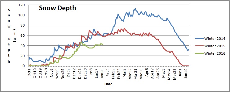
Right now Badger is about halfway between the historic average and the historic minimum, but as the graph will tell you, only half of the years snow has fallen by now, and a big February or March could change things drastically.
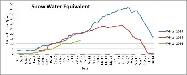
Consider 2014, when my route took me over Badger on the way south. The SWE and snow depth chart for that year not only shows a lot of snow depth on May 28th, it shows a snow pack which was loosing depth faster than it was loosing water. That means the snow was compacting, rather than melting, which when you also have reasonably low daytimes tempts means snow which can be walked over without snowshoes and without postholing. I still brought snowshoes that year, as a lack of freezing nights and plenty of rain leading up to go day made it likely that lower elevation snow would be slushy. It was, and had I not had snowshoes the ~5 miles along Muskrat Creek to Beaver Lake would have been very slow. I kept my snowshoes on for the climb up and over Badger, but I did not need them.
Another thing to keep in mind is that in the two weeks prior to the Open the Badger area had lost 10 inches of SWE. That’s a lot, which I saw on the morning of day 2, when the Strawberry Creek ford right about the Middle Fork origin was up in the weeds and well over head high, compared to the year before when it wasn’t even knee deep.
Now look at the same data for 2013. Badger lost 10 inches of water in the same period of time leading up to the Open, but two things are worth noting which explain why that crossing of Strawberry was so mellow. First, the Badger area started with a bit less SWE, and meltoff started a bit earlier and was happened faster. This is significantly because the headwaters of Strawberry face dead south, and can be assumed to have melted considerably faster than the snotel area itself, which faces north. Second, the data shows a small plateau in snow depth which happened on memorial day weekend. This is because that Friday and Saturday were both fine sunny, mellow days, with clear and very cold nights. Sunday morning I woke up a ways past Wrong Creek on the North Fork of the Sun and my shoes were frozen solid, at a fairly low elevation. This pause in melt dropped creek levels considerably, even though the larger rivers did not. The Middle Fork dropped briefly below 10000 cfs at West Glacier, but my on the ground recollection is that most of the creeks dropped far more. The exception was of course south-facing creeks with relatively high elevation, multi-aspect headwaters, like Lodgepole and 25 Mile.
Charts are your friend.