Seeking New Vistas
With 1.3 million acres of wilderness conveniently located a few miles from my house, I don’t have to look far when I want to hike to subalpine lakes, meadows, peaks, or amble beside a mountain stream through coniferous forest.
I’m able to plan many trips on short notice since there’s a bare minimum of logistics involved, and as someone who is not averse to visiting the same places, I never feel like I’ve seen all there is to see in my local mountain range.
But during the shoulder-season months when backpacking in much of the Northern Rockies tends to be an exercise in frustration, I often travel a bit further afield to reach more accommodating environments for multi-night trips. And sometimes, like almost all backpackers, I want to experience hiking through a landscape with different geology, flora, and fauna than I’m accustomed to.

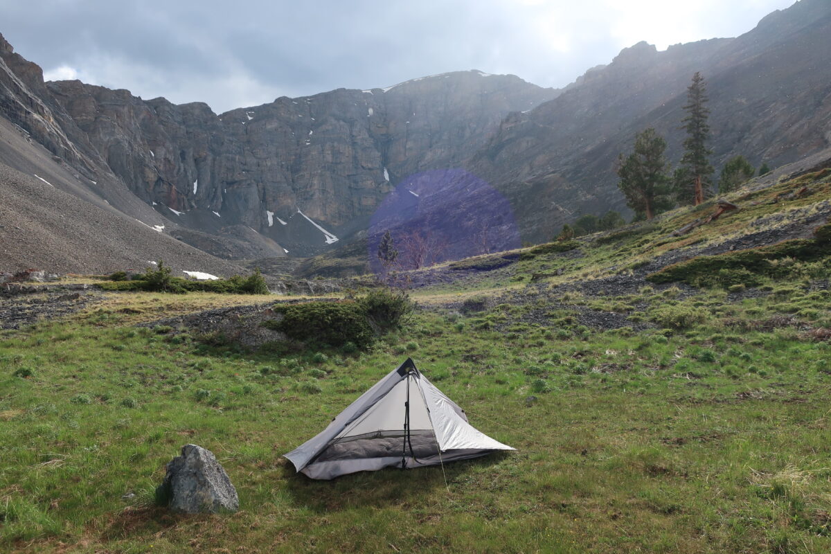
The Lost River Range in Idaho had piqued my interest over the years. It wasn’t until this past summer that I was able to carve out the time to drive 200-plus miles south for a backpacking trip there. I’d read, and re-read, a compelling description of a 40-mile traverse of the range in Backpacking Idaho by Doug Lorain and had done some day hiking and rock climbing in the area the previous September. A trip to Craters of the Moon National Monument in April took me directly past the Lost River Range. Its snow-covered peaks stretched skyward past 12,000 feet and a coniferous forest striped the middle elevations before fading into the high desert of the valley floor. After seeing the Lost Rivers then, I became determined to do a proper backpacking trip there over the summer.
Since the most practical way of doing the trip would involve a shuttle, I got in touch with my friend Jim, who’d previously expressed interest in exploring the area. We’d done several trips together, from long day hikes to a four-day trip along the Selway River, and fortunately, our schedules aligned and we were able to tentatively commit to a week in late June for this trip. I can imagine some incredulity that we would set aside an entire week for a mere 40-mile trip, a distance which many lightweight backpackers would easily tackle in a weekend, so I’d like to take this opportunity to provide some clarification before I get too deep into this narrative.
A full day would be consumed just by driving down and setting up the shuttle, with distance and the range’s notoriously bad roads working against us, and we would camp at the trailhead the night before our trip. We also wanted to give ourselves plenty of time for side trips and to enjoy our time in such an impressive landscape. And, perhaps most importantly, we didn’t want to overestimate the progress we would make as there were significant portions of our route which lacked any trail whatsoever, and other sections where the trails we would be hiking on were unmaintained. After my firsthand experience with the trip, I can wholeheartedly attest that this paragraph from the trip description in Backpacking Idaho was not an exaggeration; if anything it was a slight understatement:
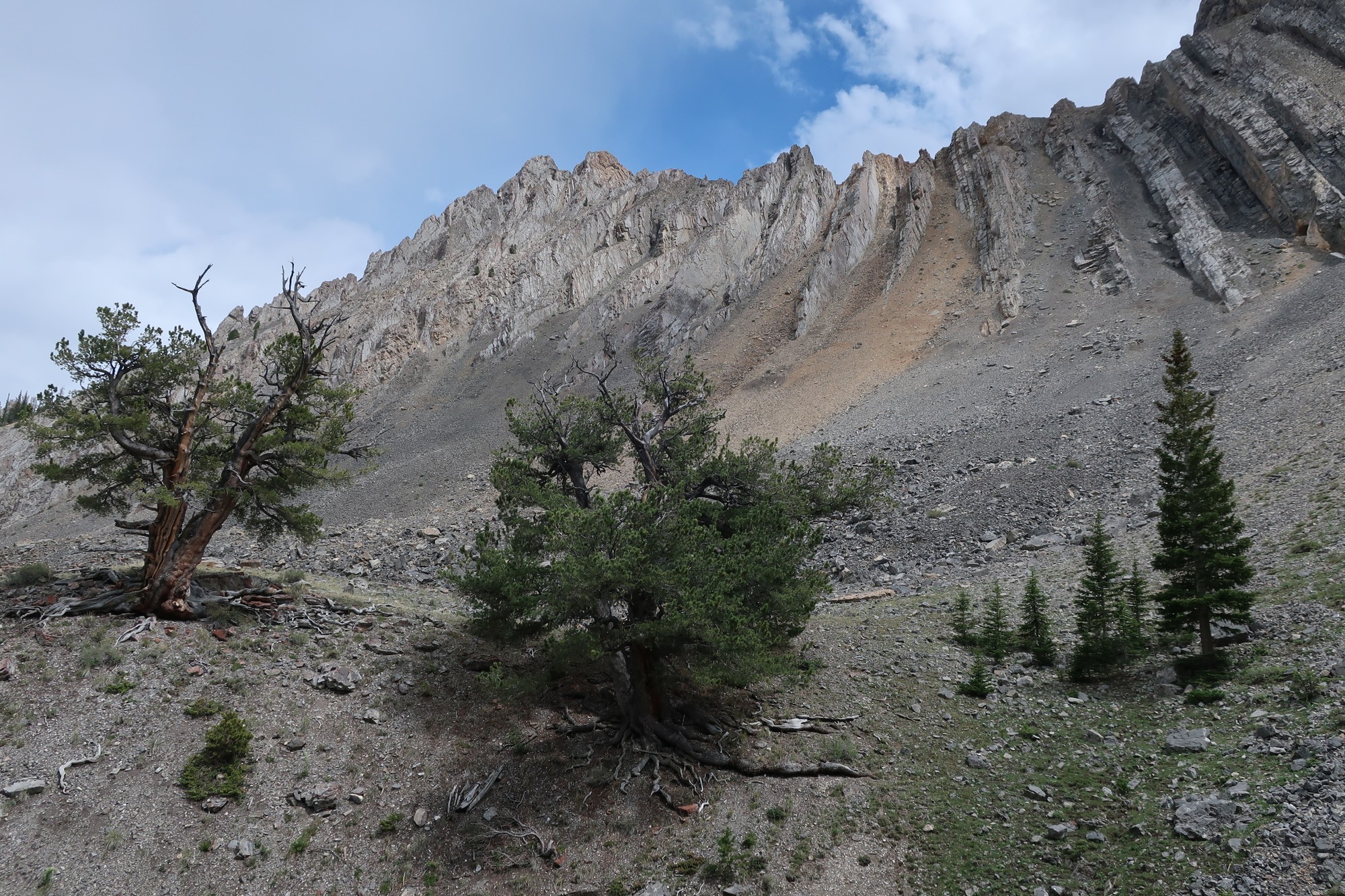
Though gloriously scenic, significant parts of this trail are so sketchy that much of the walking is effectively cross-country. In addition, junctions are almost never signed and many trails shown on the U.S. Forest Service maps either do not exist or are literally miles from where they are indicated . . . this trip is recommended only for experienced hikers who don’t mind doing some bushwhacking to follow a poorly signed and rarely traveled route.
Rather than finding that a discouraging caveat, both myself and Jim thought it seemed like the perfect trip to kick off the summer backpacking season. And having done several backpacking trips with Doug, the author of the guidebook, and working with him as a co-author on a guidebook for backpacking in Washington, I felt confident that our metrics for difficulty were similarly calibrated.
Member Exclusive
A Premium or Unlimited Membership* is required to view the rest of this article.
* A Basic Membership is required to view Member Q&A events

Discussion
Become a member to post in the forums.
Companion forum thread to: Cutting it Short in the Lost River Range
Mark Wetherington confronts the novelty of bailing on a trip after things don’t go as planned in Idaho’s Lost River Range.
Mark, I appreciate you sharing your experience. Sometimes its best to follow your gut instincts vs quantifying every detail. Choices like you made have faced me more as I grow older (65). Bad knees, a bad hip, a heart condition – are all factors. Friends tell me to stop solo trips. Im not to that point, but my solo ttips are shorter, less risky and always with the Garmin Mini. There is no shame in being wise!
I was both surprised and thrilled to see that you had come over to the Lost Rivers for an adventure. I’ve been camping, hunting, hiking, and climbing there for over 35 years. Truly it is one amazing place. There really isn’t much info, and even fewer trails to follow. Its an Alpine climbers paradise in the winter. Animals there are not used to seeing people, and the climate and terrain are simply iconic. Good on you for making the effort!
Hiking solo it is especially important to exercise prudence. At least 2 of my best experiences backpacking have involved turning around or re-routing a solo trip.
The best solo adventure bailout/’failure’ was going over the rim north of the Paliku cabin in Haleakala and trying to hike down through the Kipahulu valley to the Hana Road and the 7 sacred pools. This was back in 1977. Haha! I’m sure I didn’t have a map or any form of shelter or raingear. Early in the day I stopped to look for the rare birds I’d read about with some binoculars I’d brought along for that purpose and evidently didn’t close them back in the case properly when I resumed motion ( thrashing along). Within a minute or so I realized the binoculars had fallen out of the case. Couldn’t have gone more than a few dozen/fifty feet. I stopped and took off my pack and went back in the direction I had come to retrieve the binoculars. No dice and really had to carefully quarter around to find the pack! Just FYI I practically grew up in a sorta semi-tropical southern river bottom version of jungle and also had by this time been through all sorts of heavily forested Hawaiian mountain terrain off trail. The only way I could really practically move along was to follow the streambed which kept every hundred yards or so going over a series of waterfalls which kept getting bigger and bigger. At some point late in the day as I was dropping around and down past about the umpteenth waterfall, a really big one about 150 feet off the upper level bench area into sort of the middle level valley towards the north side of the greater valley I gained a rare clear view downward towards the sea since I was on the rim of this big drop, and the valley down below me just corkscrewed downwards and to the right and out of sight like it was going down a manhole and I finally saw and realized I shouldn’t try to keep going down towards the ocean. It was time to make a camp for the evening and retrace the next day; so I climbed back up onto the upper bench above and to the S-SE of the streambed; found a nice dry little cup in the forest floor between some big trees and made camp. The next day followed pig trails back up the drainage. It was such a tangle, like the Hawaiian version of a Smokies rhododendron or N Cascades alder hell. Often or even usually I was not even walking on the ground. I was really careful realizing that any slip/accident that stopped me from locomotion would likely be the end of me. Boy was I glad to cross the rim back into Haleakala!
Anyhow thinking about that adventure and prompted by this excellent article I searched quotes about ‘failure’ and found a list of @ 30 that had a pretty consistent set of themes.
1. If you don’t dare to try you might not ever ‘fail’ but then again you never really ‘succeed’ either. “Only those who dare to fail greatly can ever achieve greatly.” – Robert F. Kennedy
2.’Failure’ is a great teacher. “Failure should be our teacher, not our undertaker. Failure is delay, not defeat. It is a temporary detour, not a dead end. Failure is something we can avoid only by saying nothing, doing nothing, and being nothing.” – Denis Waitley
And This one: “I have not failed. I’ve just found 10,000 ways that won’t work.” – Thomas A. Edison
And re-evaluating, bailing or turning back are just steps in the greater trip. “We are all failures – at least the best of us are.” And a real classic
“You build on failure. You use it as a stepping stone. Close the door on the past. You don’t try to forget the mistakes, but you don’t dwell on it. You don’t let it have any of your energy, or any of your time, or any of your space.” – Johnny Cash
And this one: “Success is not final, failure is not fatal: it is the courage to continue that counts.” – Winston Churchill
“Carry On”
An interesting read, thank you. I felt empathetic remorse for you in the truncated trip, especially after all the effort that went into the planning, logistics etc., but sometimes you just have to make that call. I’m not familiar with the area at all so I may have reconstructed the first day in correctly, but I’m guessing you ended up above the round lake in the next cirque east of Shadow Lakes, at approx 44.03544, -113.53705? You appear to be in such a cul-de-sac there, I’m just sort of curious what the plan for the rest of the trip was? Hiking up Big Creek looks relatively benign compared to whatever might be coming next.
Philip — Yep, you’re correct on where we camped. It was an incredible place. The plan was to descend back down Big Creek a mile or so and then head over to Shadow Lakes via an unnamed pass and faint trail and from there continuing northwards via “trails” and cross-country hiking to pass Swauger Lakes, eventually hit the East Fork of the Pahsimeroi River, walk roads for a bit, pass Merriam Lake and Pass Lake near Leatherman Peak, and then exit at Sawmill Gulch on the west side. This is the route described in “Backpacking Idaho” — talking with Doug about it after my trip, it seems safe to say that the “faint trails” he referred to are virtually indistinguishable now and the “obvious trails” are becoming fainter. On the bright side, there was some signage at junctions that we didn’t expect which was a good sign (pun intended), but that was at areas with OHV use and closer to roads/campgrounds.
If you look on the USFS layer on Caltopo, many of the trails shown are not in the right place or don’t exist (we knew that going in), but it’s amusing to look at it now and see a trail supposedly leaving the basin at the head of Big Creek and dropping over to Shadow Lake.
Steve — I’d been excited to get into the Lost Rivers for years and am already excited about going back. The range is so fascinating to me and I’d love to go spend a few weeks there car camping and doing day hikes, long bike rides/bike packing, and more backpacking. I definitely plan to get down there again next summer. It’s just a bit of a drive from Hamilton and my vehicle (not to mention my nerves) aren’t well-equipped for traveling the roads in the range. My next trip will probably just be backpacking to set up a base camp spend a few days poking around and going up some of the peaks.
Glad you all enjoyed reading this piece!
The Lost Rivers are truly amazing! There are some really big peaks, and really big faces on many of them. Borah, Leatherman, Breitenbach, Donaldson, Lost River Peak, and a few others are routes we climb in the winter, as the ice holds the rock together! LOL The East Fork of the Pahsimeroi valley might be one of the most beautiful cirques in all of Idaho. The absolutely insane face of Breitenbach looms over it all. We have had the most success crossing ridges via elk, deer and sheep trails. They seem to go where necessary. This is one wild place. You might look at basing here and moving south thru the range…
I scrolled around the area in google earth a little, roughly following your landmark breadcrumb trail description, and some of the terrain looked consequential. But I also saw what appeared to be some very obvious trails that could get you through those sections. It is not clear to me if they were made by feet, paws, or hooves (and I know from the mountain goat trails here on Kodiak that you sometimes don’t want to follow them, haha), but consider the example below. This is a pass leading down to Shadow Lakes from the Big Creek drainage. The contour lines on the topo map are frighteningly close together, and the shadows cast by rock fins in the satellite image give it a creepy, scaly look. But then you can distinctly see switchbacks up the lower slope and routes through the rock bands on the upper left. Kinda crazy looking.
Thanks, Philip! I believe those switchbacks are described in the guidebook description for that area, good to know that those actually do exist compared to some of the other parts we hiked.
The last couple of years I have bailed out of several hikes for different reasons. Most of them were the result of being slightly to ambitious, either for my capabilities or those of my hiking partners. I have learned two things from bailing. First; start more slowly and save longer hiking days with big climbs for after day two. Break up long, tough sections in shorter ones for the first two days. Second: be flexible when it comes to a schedule. Don’t push to hard to make it to a certain place, if that means you’re really exhausting yourself. You’ll often pay the price the next day. If you’re tired, cold or if the weather turns bad, just call it a day, make camp and enjoy the evening. Save some energy for the next day. I have learned the hard way that hiking is a multi-day marathon, not a sprint (and that I’m probably not as fit as some people 20 years younger then I am). So nowadays, I always try to plan with an extra trekking day as an option. That has made it easier to stop when we felt like it. The last couple of 100km+ hikes went without problems and were so much more enjoyable because there was no stress and more time to relax, sip tea and enjoy the scenery.
Become a member to post in the forums.