Stories Begin to Appear
I picked up my friend Clayton from his apartment near the University of Utah and we headed south from Salt Lake City on I-15 with snowflakes swirling around us. The pale sky made me cold as I imagined backpacking in the Bear’s Ears area in January. I reached for the heat and slid the dial a bit more to the right. Warm air blasted my face. Was I prepared for this?
It would be my first adventure in the Bear’s Ears area. Prior to this trip (which occurred in my early 20s) I had been more interested in the simple aesthetic beauty of desert canyons. Water pouring over orange sand, and fragments of the cobalt sky reflected in it. But after a while, I started to think more deeply about places. The beauty remained, but it began to penetrate time in both directions: centuries into the past, and centuries into the future. And if a particular place — say, Coyote Natural Bridge in Coyote Gulch, for example — was here 800 years ago, who walked under it? What did it mean to them? As these questions developed, the existence of the stories of the land began to appear. But not the stories themselves, just the fact that they exist. I could start to see them, like unlabeled books on a shelf I couldn’t quite reach. First I would have to start walking and asking questions, then maybe, just maybe, a few of those layers would start to reveal themselves.
First stop: Comb Ridge.
By the time we were bumping down Butler Wash hours later, I could suddenly smell beer. One of the beers behind the seat had sprung a leak from all the jostling back and forth.
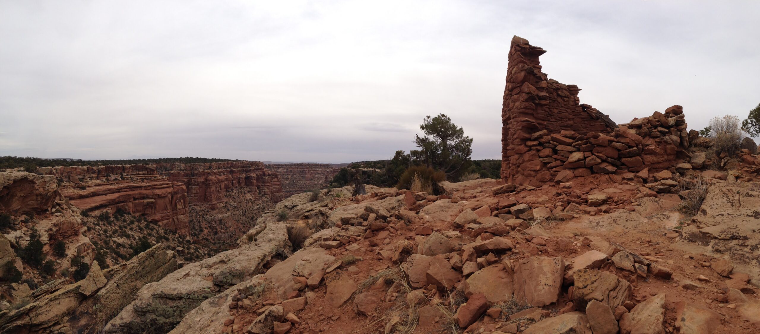
Just before the golden hour, we found a pullout in a cow-trampled sagebrush flat. There was an old, rusted-out trough being used as a fire ring. We decided we’d use it too. But first, we would walk up the nearest arroyo we could find towards Comb Ridge. I had heard that there were ruins in every single one of these little canyons, so choosing at random would be a good test. Before we even entered the short canyon we spotted a granary high up on the cliff. We both wondered aloud how they reached the spot, much less built a structure there.
“Don’t you think you could prop a log up there and then use that ledge to pull yourself up?” Clayton speculated.
“Maybe,” I said. “But then think about hauling those bricks up there.”
“True.” Said Clayton.
We kept looking for a minute but the puzzle did not come together, so we decided to let the structure remain a mystery and turned and walked up the canyon. Within a few hundred feet we found another structure, this one at ground-level, against a south-facing cliff. It was in sad shape. The roof had long since caved in and the walls were working their way to the earth. Old, dried fragments of cowshit peppered the dirt floor, and coarse, black hairs clung to the edges of walls where cows rubbed against them scratching gnat-bites and fly-bites. No wonder this old house was falling apart — its new tenants were the wrong size.
The clouds above us turned from gray to orange against the turquoise January sky and we began to amble back towards the car. That night was around zero degrees Fahrenheit (−18 °C) and my sleeping pad deflated: Russian thistle, I assumed. I cursed the cows (misdirected curses, I know) silently as I got dressed in the dark. I dug an old synthetic sleeping bag out of the car, walked back to the tent, and placed it over the deflated pad. I removed my shoes and reentered my bag shivering. I waited for cold spots. None. It worked.
The next morning we hiked to the top of Comb Ridge so we could get a better idea of where we were. There was the big, juniper-covered mound of Cedar Mesa to the west and the slightly taller Dark Canyon Plateau to the northwest, where the namesake buttes of Bear’s Ears sit. In the south, beyond the long spine of the ridge was the San Juan River. I couldn’t see it, but I knew it was there. We didn’t linger long though — we were on a mission.
The Fight For and Against Bear’s Ears
We sat at the top of Comb Ridge in January of 2011, so about five years before the area would come to be known as Bear’s Ears National Monument. Most of what we were gazing out on — and much we couldn’t see from that vantage — would be included in the designation. I didn’t know it, but around that time moves were already being made to increase protection in the area. Just a year later, in 2012, the nonprofit Utah Diné Bikéyah (UDB) was formed.
Utah Diné Bikéyah began to create a comprehensive ethnographic map of the area, plotting the layered histories of several cultures as a starting point from which to begin thinking about how to implement a new conservation strategy. By 2013 they had come up with a proposal for the Diné Bikéyah National Conservation Area, which was about 1.9 million acres (7,690 km2) in size. In response to these efforts, Utah Congressman Rob Bishop along with Representative Jason Chaffetz drafted the Public Lands Initiative (PLI). What appeared at first (as promoted by PLI representatives) like a conservation compromise actually documented policy proposals that would increase extractive activities1, reduce decision-making representation of tribes2, and ensure that future presidents would be unable to designate a National Monument in the seven counties participating in the PLI and where future monument designation would be most likely.3
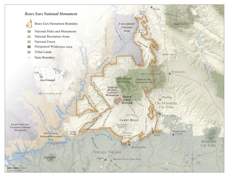
In response to what has been called a bad-faith PLI, the Bear’s Ears Inter-tribal Coalition was formed in 2015. The group is made up of five tribes: Navajo, Hopi, Zuni, Ute Mountain Ute, and Uintah Ouray Ute, each of whom has deep connections to the Bear’s Ears area. They encouraged President Obama to designate those 1.9 million acres identified by UDB. His administration considered both UDB’s 1.9 million acres and the smaller proposal laid out in the PLI’s map, eventually settling on 1.35 million acres for Bear’s Ears National Monument, which was somewhat of a compromise. Of course, not long after this, President Trump reduced the area by over 80%. Now a third administration is looking at the monument. President Biden signed an executive order on his first day in office, promising to have a look at the boundaries. Secretary of the Interior Deb Haaland, the first Native American in a President’s Cabinet, visited the area the second week in April 2021.
The Ruin
All the while, I have backpacked periodically in the area, seeking out well-known ruins, stumbling across surprises. Back in 2011, when Clayton and I were given rough directions to a site of particular interest, my coworker had drawn his finger in a circle around an area of the map, a vague, mile-wide radius. He said he didn’t want to give us precise directions because that would ruin the thrill of the hunt. A mile radius looked small on the map but would be a different story in reality.
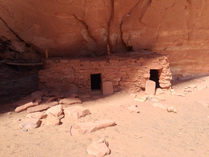
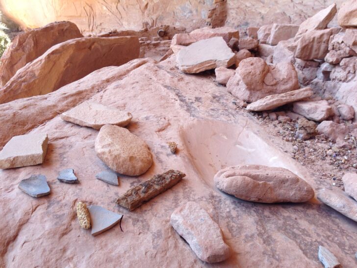
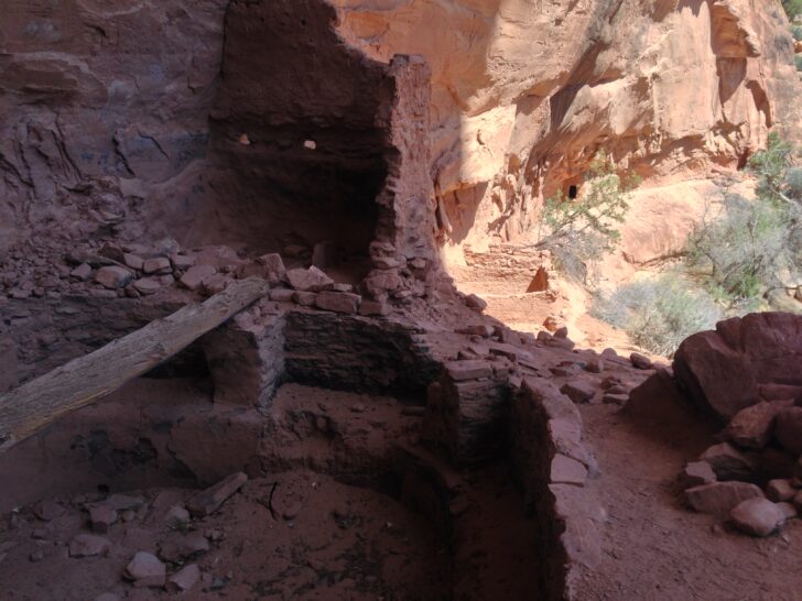
The snow was six inches deep as we plodded into the canyon in the light of day. Though it was barely above freezing we were soon in t-shirts. At the bottom of the canyon, the snow was even deeper, almost a foot in places. We walked into the vague radius that housed the site and looked at the terraced canyon walls for some sign of residence. If I had to live there, where would I choose to live? Clayton continued up the canyon while I scrambled upwards to what had the appearance of being a good lookout. There I found a small ruin with three doors, a second small ruin, and the whole high shelf strewn with potsherds.
It wasn’t the site we were after, but something about it completely bowled me over. I picked up small, grey corrugated pieces with the fingerprints of their makers still pressed into them. The clouds above the canyon, flat and gray just a second prior, became orange catching the last light of day, and suddenly expanded like leavening bread towards the earth. The sudden closeness of the sky, the descending cold, the inevitable night, and my aloneness at the site sent me hurtling through time. Or rather everything that ever was and would be seemed to be happening all at once. I had been to Mesa Verde, the Pantheon, and Se Grada Familia, and those places had filled me with awe, but not like this.
I replaced the tiny pieces of broken wares and looked at the sky. Fading fast. I’d better get going. I scrambled down, being careful not to slip on the snow-covered slickrock. Clayton and I reconvened at the bottom. He told me he had stopped looking for the site altogether, instead following a deer track just to see where it went. The snow was deep and the night began to get colder. The sky went from winter-blue to purple and the leavened, orange clouds deflated and retreated back into the firmament far from earth. We never found the site but it didn’t matter.
How Does a Backpacker Give Back?
I, of course, didn’t take any potsherds, arrowheads, or corncobs. The only thing I took away was the experience of being there: awe, wonder, and feeling like I was seeing into deep time. But, according to archaeologist and conservation advocate R.E. Burrillo in his book Behind the Bears Ears: Exploring the Cultural and Natural Histories of a Sacred Landscape, I may still have been engaging in what could be considered a form of pillaging. Let me explain.
Burrillo tells the story of getting his truck stuck in a creek in the Bear’s Ears area around Christmas many years ago. He is saved by a climber who winches his truck out of the ice. The climber asks Burillo why he likes archaeology. “What I said at the time is that I love hiking and backpacking to archaeological sites, investigating and taking photos of them,” Burrillo says. “Becoming an archaeologist meant turning my favorite hobby into a job, as Confucius supposedly advised.” The climber thought about this and then asked him what he gives back.
Burrillo had no good answer at the time. The climber said, “I know a lot of people who don’t give a shit, they don’t think much deeper than buying new gear and putting up routes, but I know these places wouldn’t look very much like this if we didn’t do something to look after them.”
Many years later, Burrillo finally found out how to give back. He became one of the primary voices calling for the designation of Bear’s Ears National Monument. He wrote op-eds, researched, and worked on advocacy projects. And, of course, wrote a whole book about the area he loves so much.
His story urges me to ask what I have done to give back. So far I have given back close to nothing. The concept of reciprocity wasn’t in my vocabulary in 2011, and now, ten years later, I still don’t know exactly how to give back to a place that has provided me with experiences like the one described here. But this theme keeps finding me, prompting me to consider it more seriously. Recently, I had the privilege of interviewing writer and adventurer Craig Childs for a podcast episode, and he touched on the same concept. “I’ll be dead and gone before I ever really figure out what needs to be fed back into this place and the people of this place,” he says. “But at least I can get close, at least I can do my best.” In his case, each book he writes is an endeavor to give back to the desert he loves. He takes what he has observed while walking through remote canyons and over orange slickrock and transforms the observations into words that have the intention of drawing the reader into the experience so that they too can develop affection for these places. Through affection we can begin to learn what a place needs, how we can help, what role we can play.
It’s a small gift, but I hope that even this article — my meager effort to become more aware of the reciprocity asked of backpackers like myself — is an attempt to give back to the places that have given me so much.
Further Reading
- Behind the Bears Ears: Exploring the Cultural and Natural Histories by R.E. Burrillo
- The Madness of Dissasociation — an interview with Craig Childs
- Biden has to ‘get this right,’ Deb Haaland says of monument decision after Bears Ears tour
Endnotes
- PLI SEC. 1102. ACTIONS TO EXPEDITE ENERGY-RELATED PROJECTS. “(a) In General. — The State of Utah —(1) may establish a program covering the permitting processes, regulatory requirements, and any other provisions by which the State would exercise the rights of the State to develop and permit all forms of energy resources on available Federal land administered by the Price, Vernal, Moab, and Monticello Field Offices of the Bureau of Land Management…” The main takeaway from this section seems to be the fact that they were trying to move energy development decision-making from the Federal Government to the State.SEC. 1103. PERMITTING AND REGULATORY PROGRAMS basically makes permitting easier.
- PLI SEC. 110. BEARS EARS ADVISORY COMMITTEE. This section of the PLI states that tribes would have had a consultative rather than managerial role with regards to Bear’s Ears. Committee members would have been chosen by the Secretary of Interior. This would have allowed then-Secretary of the Interior Ryan Zinke to choose people who wouldn’t be noise-makers. In addition, these committee members would have had to live in Utah which leaves the Ute Mountain Ute Tribe (located just across the border in Colorado, but still with a strong vested interest in Bear’s Ears), out of the decision-making process.
- The Antiquities Act provision is in section 3 of H.R.5781 which was a companion bill to the PLI. It reads: “A national monument designation, or a boundary adjustment that increases the size of an existing national monument, under section 320301 of title 54, United States Code, within or on any portion of Federal land in the counties of Summit, Uintah, Duchesne, Carbon, Grand, Emery, and San Juan, in the State of Utah, shall be made only pursuant to an Act of Congress.”
Related Content
- More by Ben Kilbourne
DISCLOSURE (Updated April 9, 2024)
- Backpacking Light does not accept compensation or donated/discounted products in exchange for product mentions or placements in editorial coverage. Some (but not all) of the links in this review may be affiliate links. If you click on one of these links and visit one of our affiliate partners (usually a retailer site), and subsequently place an order with that retailer, we receive a commission on your entire order, which varies between 3% and 15% of the purchase price. Affiliate commissions represent less than 15% of Backpacking Light's gross revenue. More than 70% of our revenue comes from Membership Fees. So if you'd really like to support our work, don't buy gear you don't need - support our consumer advocacy work and become a Member instead. Learn more about affiliate commissions, influencer marketing, and our consumer advocacy work by reading our article Stop wasting money on gear.

Discussion
Become a member to post in the forums.
Companion forum thread to: The Overlook: Giving Back to Bear’s Ears
Ben Kilbourne reflects on his first journey in the Bear’s Ears National Monument, and wonders how to give back to such special places.
Nice. And while it is quite easy to find ways to give back in many of the wilderness areas of the USA (volunteer trail work, etc.) the Southwest presents a different challenge. Speaking out about the need to protect it is probably your best bet!
Well said Ben. Being in a place also means being in a community, one that stretches both backwards and forward through time.
Fight climate change to save it, and everything else.
Having lived in Blanding for a while, I learned to love the area that Bears Ears now encompasses. I enjoyed your article and photos. One of the best things about this area was the scarcity of visitors. Very rarely would we see another soul. Many of the most secret places remained un disturbed year after year. Now, with so much publicity there are more and more people going there. The secrets will soon be discovered and sites looted. I am not convinced that making it a National Monument is a good thing or bad. Time will tell.
Drew – Community is a word I failed to use in the article, but it’s spot on. It’s exactly what I’m talking about. Asking how we can learn to become members of a community that encompasses landscapes and their past and future humans.
Tim – I hear you. I tend to think some protection is better than none, but I’d hate to see it share the fate of Arches National Monument. To my mind, this is one reason tribal management is so important here.
“Fight climate change to save it, and everything else.”
Yes. This.
How about pitching in? Friends of Cedar Mesa
The first 10 of you that pitch in $25.00 I’ll match.
If you live nearby you could also volunteer in many ways, like being a site steward for one of those sites up one of those umpteen mini-drainages on the east side of the Comb like the one Ben described.
You can petition Google to quit posting photos with the location of so many sites. A few years back they had 3-D; I guess drone shots of map sections about a mile north and south and @ a mile wide east and west of the point where 95 breaks through the Comb and crosses Comb and Butler Washes. The sites in this area located up under alcoves could then be visually seen using the 3-D controls. You could literally fly up under the lip of an alcove and look in to see if there was a site. Not helpful! That feature has since been removed but there’s still lots of photos tagging sites.
When you visit a seldom seen site you can practice ultra leave-no-trace. If there is no trail or tracks leading to the site then don’t leave any of your own! It takes just one group of 3, 4, 5 people walking single file to leave a trail to a site anyone can follow and next thing you know there’s a beaten path, Sneak up on sites. Come from the “wrong” direction. Don’t leave a path.
Ben mentioned Craig Childs in the post. There’s a site in his book House of Rain that he refers to as the Red Knobs and he makes a very general reference to it’s location. I decided after reading it that I was going to see if I couldn’t find the Red Knobs even if this seemed sort of like finding a needle in a haystack but he provided a general distance and a general direction from a local town and also the site was sort of described by the name. I guess this must have been @ 2009. Anyway sure enough I found it. It was just like Craig described; so many potsherds scattered over acres you had to pick your way along to avoid stepping on them. As soon as I realized I was “on it” I started sneaking around and trying not to leave tracks, walking on slickrock, through bushes, hopping from rock to rock, anything to avoid leaving a trail. I came back 3 times over the next @ 6 years or so with a friend each time and we always took a circuitous route and tried to avoid leaving tracks.
The last time was in March 2015 just after things had melted out enough to get there. The water was high enough in Cottonwood that crossing was dicey. We snuck in and checked out the main site. There were very few sherds visible and almost none that weren’t the grey utilitarian ware. No color. We went over to check out the annex and found a set of footprints all along the edges where a recent rainfall would wash out soil and in effect “excavate” cultural material that had been previously buried. I could scarcely believe somebody had been there and clearly scouted for relics on practically the earliest possible occasion for the year. This was @ 7 years after House of Rain was published in 2008. I haven’t been back since.
Maybe the site doesn’t have those hundreds or thousands of potsherds anymore because some archeological team had conducted a site survey and picked them all up. I sure hope something like that occurred. I don’t know if that’s the standard practice. It’s probably just wishful thinking on my part. Did I leave tracks that someone followed and then several other someone’s? How many does it take to practically clear acres of sherds? Is there a market for colorful patterned sherds? There was no evidence of any paths leading to the site. All I know is that the site Craig saw and described and I saw back in 2009 was completely changed and in some ways gone never to be seen again. It’s a sobering thought.
I think if people care enough about this to figure it out, to find some of these sites the old fashioned way before the internet and weblogs etc. To have to discern the patterns, learn where to look and how to look and have to get to places the old fashioned way on their own hind legs and can’t just drive up to a site on a whim; they’ll learn along the way that these places are fragile and precious. They learn to be stewards of what Fred Blackburn called the outdoor museum when describing the Bears Ears area.
BTW Ben WRT Time; besides the occasional dinosaur footprint or fragment of petrified wood there are those beautiful smooth multicolored stream bed rocks up on the Bluff bench 100-200 feet above the San Juan which are twice made rocks; first coming from mountains maybe a billion(s) of years ago and washed and eroded down to the bottom of the big sea that covered the area of the Colorado Plateau to become pressurized into dense sedimentary rock before the more recent plate tectonics that raised the Colorado Plateau, the Rockies and the beautiful San Juans. Then somehow washed down the river from the San Juans to end up high above the river on the bench. Hold one of those in your hand and ponder time.
And there is the Clovis site on a bench somewhere west of the Comb on Lime Ridge where they evidently hunted mammoths. Also on a stone face along with all sorts of other rock art hundreds or thousands of years old west of Bluff near Sand Island there is what may be one of only 2 ancient artistic depictions of a mammoth so far located in the western hemisphere. The other was found carved onto a mammoth tusk near Boca Raton Florida. ( there’s the usual rigorous scientific debate. about the petroglyph near Bluff. Harder to argue with a carving of a mammoth on a mammoth tusk. How do you prove the age and origin of a petroglyph? But hey we can have a bonfire and dance around it for fun anyway!) Deep human history indeed.
Wonder what happened to the comment that I left after the initial post. Maybe I left no trace. Hmm.
I am all for trying to preserve something for the sake of others to enjoy and practicing reasonable LNT policies but when the conversation tilts from things like being responsible and courteous to people and treating the land/historical sites as respectfully as possible, to a conversation about how to prevent others from sharing the experience, the intent of the conversation seems to get a bit ethically “wobbly”. I definitely agree with most of the sentiments stated here; give to groups who are trying to preserve for the enjoyment and education of others, time, money, whatever you have and are willing to share; respect the land and respect others who will want to have a similar experience. Nothing lasts forever, so we shouldn’t expect these sites to either, but that doesn’t mean we need to have a hand in their destruction.
?
Are you describing the comment about tagged photos? Maybe that’s the wrong terminology. What they have on google maps is dots on the location of a site that then open to show photos which when it’s an archeological site are photos of the site. It’s possible that most of these are what might be described as “sacrificial” sites but the whole practice still makes me uneasy. There was a period a few years back where they were posting everything that someone decided to post but that seems to have been curtailed.
Hey if I said something to indicate that access should be limited or prohibited or anyone got that message I apologize. Though there’s a difference in limiting or regulating access and requesting google, in the interest of protecting sites which cannot be supervised, defended or otherwise protected; from being literally promoted. Hey the photos and spot locations are literally on the map.
I would recommend another one of Craig Childs books named “Finders Keepers” as some background on the hmmm, delicate ? situation regarding this great outdoor museum ( from the book Cowboys and Cave Dwellers) and the potential problems resulting from ahmm careless visitation, vandalism or looting.
I could maybe think of some other way to put it but I’ll stick with what I posted earlier:
@obxer: I just contributed $100 to Friends of Cedar Mesa.
Spent the money to save a sacred and incredibly beautiful place instead of getting that next bit of gear candy.
Who’s next?
People steal stuff, and they especially like to steal Native artifacts – have from the beginning of Europeans arriving. Archives (I oversee one) have a protocol for who may see records that have recorded locations of archaeological sites; if these are not restricted, grave sites will be robbed, historical remnants will be pillaged. It’s a real conundrum providing access to pictographs or other sites so that people can learn, appreciate and enjoy, but also finding ways to protect them. Educating the outdoor community doesn’t seem to be sufficient, or perhaps some people are simply uneducable, or just truly selfish. It has to start at age 5.
Just donated $25 to Friends of Cedar Mesa.
Karen I’ll be matching your and David’s contributions in your names.
Well put. You want people to get involved, to experience these sites, this really special area. You want to share these experiences but you don’t want it to be trashed, hauled off, defaced or destroyed.
The Friends of Cedar Mesa have done amazing work that led to the monument designation and they’ve worked really hard and continue to work to get people involved and help them become a part of that community Ben was discussing in the article.
Article in todays NYT: Women of Bear’s Ears
Which reminded me of another story: The Story of Wolfkiller
For your Sunday reading entertainment.
Become a member to post in the forums.