Introduction
After some Type 2 fun triggered by following an overgrown path, I decided that for solo hikes, I would stay on well-maintained trails using simple backpacking navigation. Hoping to keep out of similar situations, I dragged an impressively heavy collection of paper maps on every trip after that.
Then, several years ago, I started planning a 100-mile loop through Marin County, California, using the usual combination of downloadable maps and online resources. At some point, while struggling with the idiosyncrasies of Google Maps, I realized that printed turn-by-turn directions might be useful while hiking.

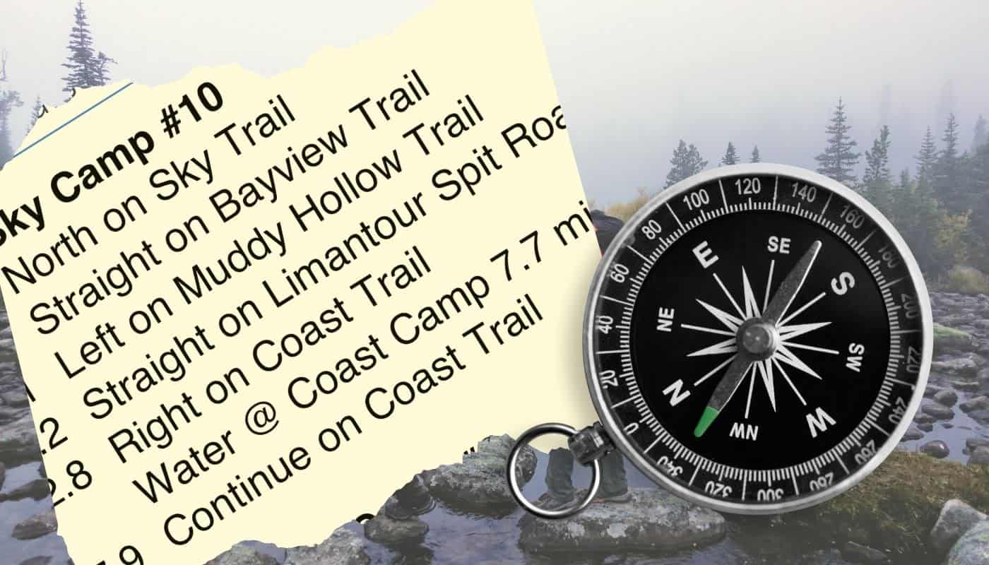
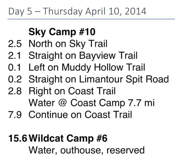
Unfortunately, Google trail names often differ from local trail names, and even our omniscient online overlord misses some trails or trail connections entirely, so I couldn’t just print those directions and move on. However, I could get local trail names and directions from park maps. I also wanted larger fonts and pocket-sized sheets. Since this trip relied on fixed, legal campsites each night, I made each day’s hike fit onto one cut-down piece of paper. I also added key information, like water sources (which were surprisingly rare on this trip), campsite numbers, and important camp amenities. After some experimentation, I came up with the following format.
Example
I was really pleased with how well these instructions worked for this eight-day trip, and rarely pulled out one of the six maps I carried. I still use this technique in areas with well-marked trails.
Advantages
- Faster and much less hassle than pulling a map out of a pocket, unfolding, orienting, squinting at small type and tiny features hidden in a forest of contour lines, head-scratching, sometimes realizing I’m off this map and onto the next, refolding, and stuffing back into a not-quite-big-enough Patagonia Baggies pocket, often accompanied by swearing through the whole process.
- Reduces my mental workload and lets me enjoy hiking more – though, after 50 years of backpacking and day hiking, I’m pretty good at trail navigation and staying found.
- Keeps important information like water sources literally right at hand.
Tips
- This works best in areas with well-marked trails and junctions, but might be tough for cross-country travel.
- It’s very useful to have a watch and a known hiking pace for dead reckoning navigation, so you’ll know roughly when your next turn should show up.
- Don’t be afraid to think “Oops, did I miss that junction?” It’s better to stop, pull out the map, reorient yourself, etc., versus plunging ahead while hoping it all works out.
Disadvantages
- You lose an innate sense of where you are, like mindlessly following spoken smartphone directions in an unfamiliar area. On the other hand, this increases the mystery and sense of exploration, even in well-traveled locales like Marin County.
- This method doesn’t work as well when you don’t know where you’ll camp each night.
- It’s hard to identify landmarks of interest, like lakes, streams, and peaks, though you could add a few, like “Mount Jordan 5 miles NW @ 1.2 miles,” or “Lake Mary on the right @ 2.5 miles.”
- You might change your route, lose today’s instructions, or need to exit early. You always need maps or a mapping app just in case.
- You could still go down the wrong trail, especially if you are dyslexic, though using compass directions and a watchband compass might help. Years ago, some jokester reversed a trail sign deep in the backcountry. I spent 20 minutes reconfirming my location and directions and exploring the wrong path before discovering fresh dirt at the base of the loose signpost.
I often make a spreadsheet with segment-by-segment mileage and other notes anyway, so creating turn-by-turn daily hiking sheets is relatively easy. For those adamantly opposed to carrying paper in the backcountry, you could put turn-by-turn directions on your smartphone instead.
Conclusion
I still carry maps for each trip and plan to try smartphone navigation soon, maybe after Apple, Google, or the Gaia GPS App add reliable turn-by-turn spoken hiking directions. “In 100 yards, turn left on the Coast trail,” or “At the next trail junction, turn right at the bright green outhouse.” I could route the voice to a Bluetooth boombox strapped to the top of my pack, automatically pausing my Grateful Dead playlist to announce the next turn. Or not.
Turn-by-turn hiking directions aren’t for everybody, but try them before you scoff and proclaim “Never!” Maybe you’ll like it. I do, for some trips.

Discussion
Become a member to post in the forums.
Companion forum thread to: How to use Turn-by-Turn Directions for Simple Backpacking Navigation
Simple backpacking navigation: turn-by-turn hiking directions aren’t for everybody, but try them before you scoff and proclaim “Never!”
Never!
Some bikepackers use the voice turn by turn. Last fall a friend had that for a pecos nm backpack.
I posted my “Never!” comment earlier just because Rex said not to. :) But I was serious, and Rex’s #1 on the list of disadvantages is reason enough. Hiking is more rewarding and fun when you know where you are, when to look in what direction to catch a subtle view, what your options are if you’re feeling your oats or tire early, what direction you’re moving if it’s overcast or foggy, etc.
As someone who has as a terrible sense of direction, I disagree with this. It’s great to know where you’re going but terrible to know where you are. The reason this works on Google Maps is that it automatically reroutes you once you’ve screwed up, which I do often.
Knowing where you are is the most important part of staying found. What I’ve found is useful is to draw your route on the map. At each junction, spend the 20 seconds to orient your map, look at the route to your next junction, make note of what you will see along the way, and then go. It doesn’t take *that* long.
In this setting, having a list of what you will see would be quite useful. If you know that you should cross a stream 1 mile away and you’ve been hiking for an hour and haven’t seen it, that should raise red flags. But navigating primarily based on the list can really get you into trouble.
I resisted turn-by-turn directions in my car, using the mapping app for a long time. Mostly on the basis that I wanted to have that situational awareness from looking at the overall route.
OTOH, I can pay more attention to the driving, lane position, other vehicles, etc if my eyes and brain are focused out the window and not at a screen. And I’ve found the pace of announcements and reminders to be about right (enough to move into the correct lane leisurely).
What I haven’t ever tried doing is using voice commands for a walking trip. My mapping app has driving / walking / transit options and shows routes for all of those. I should try it for spoken walking directions sometime.
I love car turn by turn directions
The best thing is to not follow her directions
I’d like one “with an attitude”. Swear at me when I don’t follow directions for example.
To be serious for a second, the directions are just one suggested route. I still have to use my judgement. For example, if she says to take a dirt road over the mountains when there’s snow, don’t do that.
Or, I wanted to go from Portland to Madras. She told me to go over the mountains by Government Camp. Trip Check showed snow on the road. I was in no hurry. I went via The Dalles. Eventually she figured it out and started giving me directions via The Dalles.
I like that it shows distance and time to destination.
None of that applies to hiking. I’m usually into hiking around, checking things out, not really into point A to point B via shortest distance. I don’t necessarily go on trails. I like the GPS map though. I’m sort of ADD following it, sort of like a computer game.
Many PCT hikers are hiking essentially turn by turn, following their linear iPhone apps which tell them where to camp, where there is water, etc. Disconnected from maps, but also disconnected from the experience. They are in turbo mode, and I often hear them say: “the JMT portion looked really nice, I will have to go back sometime to enjoy it”.
Become a member to post in the forums.