Arriving at the Pukaskwa
“YOU ARE HERE!” the map at the Hattie’s Cove Visitors Centre told us. “Here” was the trailhead of the Coastal Trail at Pukaskwa National Park, the result of a 2-day, 13-hour drive from Toronto, and a year’s worth of plans, training, dreams, and excitement.
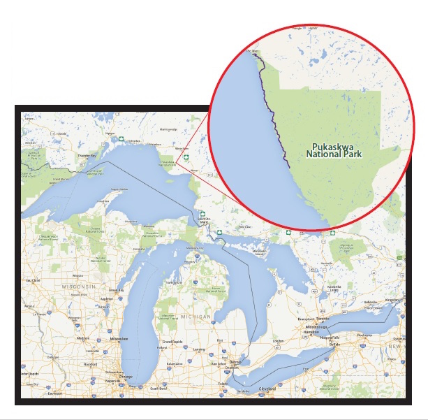
A trip in the making since we completed the Coastal Trail at Lake Superior Provincial Park last season, our dream was to travel once again to the majestic Lake Superior region. We wanted to experience the ethereal beauty of the world’s largest freshwater lake: this time, in Pukaskwa National Park, four hours further north than last year’s trek.
Parks Canada is the federal body responsible for Pukaskwa, the only wilderness national park in Ontario.
Pukaskwa National Park protects over 1,800 square kilometers of ecosystems that include boreal forest and the Lake Superior shoreline. Falling within the traditional territory of the Anishinaabe people, Parks Canada works collaboratively with local First Nations to protect and preserve the land and educate the public. By reputation, the Coastal Hiking Trail at Pukaskwa was more wild, remote, challenging, rugged, and beautiful than its Provincial Park counterpart. We had to find out for ourselves!
The Trip Planner (a park-issued mini-guidebook) told us that hiking times in Pukaskwa were based on a hiker averaging 0.9 mph (1.5 km/hr) over rugged and slippery terrain with a 35 lb (16 kg) pack. All hikers, we were advised, should be experienced backcountry hikers. The one-way Coastal Hiking Trail had no road access at the end; the only way out was to take a shuttle vessel back up the coast or to turn around and hike back. The cost of the boat was prohibitive for us; and so our plan was to hike the Coastal Hiking Trail to the end and back again, a total of 75 miles (120 km), allowing ourselves nine days to complete it.
After a brief orientation session with park staff and a final quick trip to the washroom, we were ready to begin. Every fiber of our being was twitching to get on the trail. It was time to make our Pukaskwa dream come true!
Day 1: The Adventure Begins
- Day 1: Aug 30, 2015
- Destination: Hattie’s Cove to Willow River
- Distance: 11 miles (17.5 km)
- Time: 7 hours
- Average Speed: 1.6 mph (2.5 km/hr)
- Ascent/Descent: 1411 ft/1398 ft (430 m/426 m)
Leaving Hattie’s Cove, Pukaskwa’s Coastal Hiking Trail first traversed through the park’s successful 2012 prescribed burn site, with interpretive signs educating us about the burn and illuminating the cycle of life, death and rebirth of the northern boreal forest.
Turning inland, the trail became a wooden boardwalk wandering through a marshy wetland.
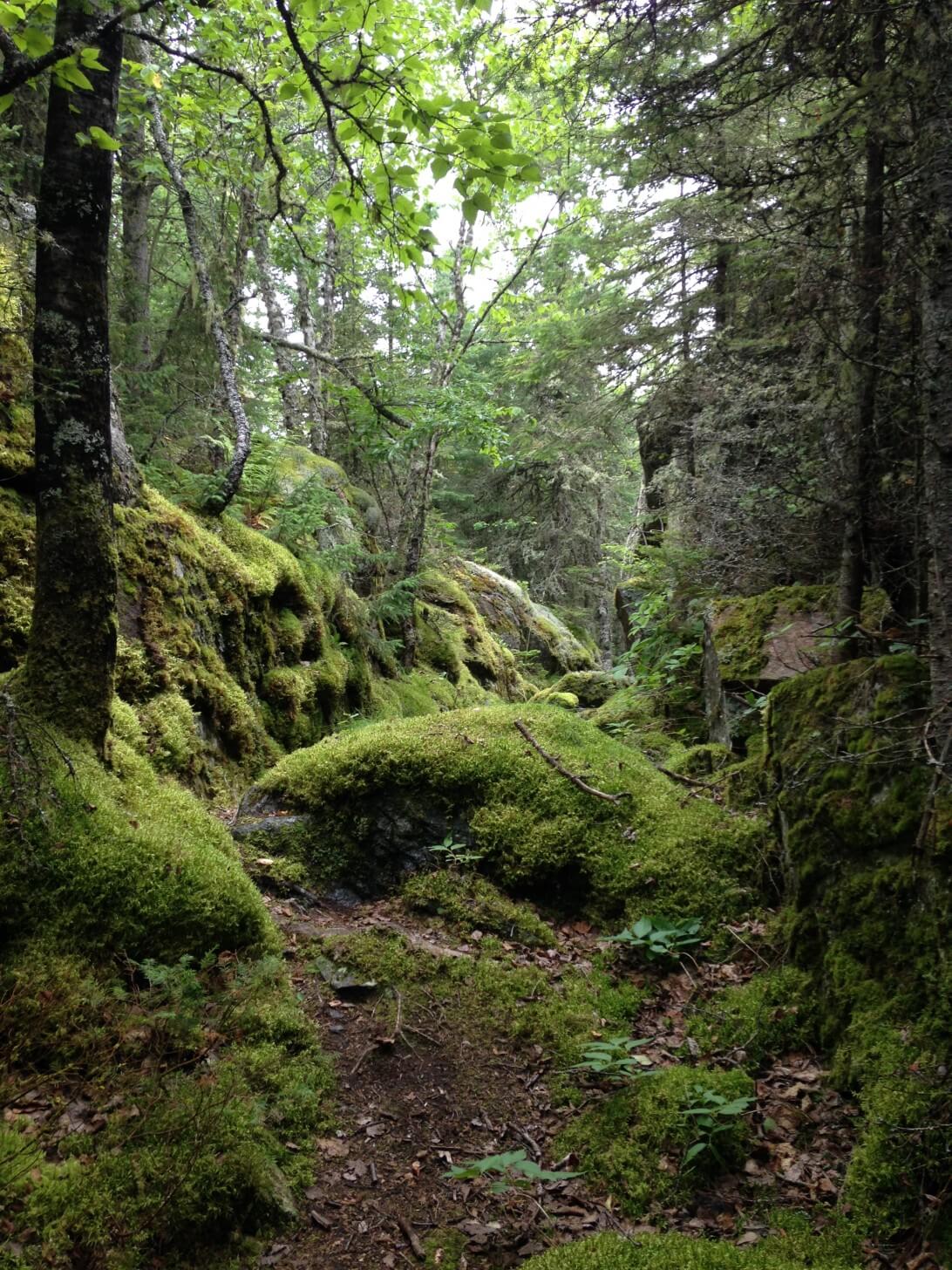
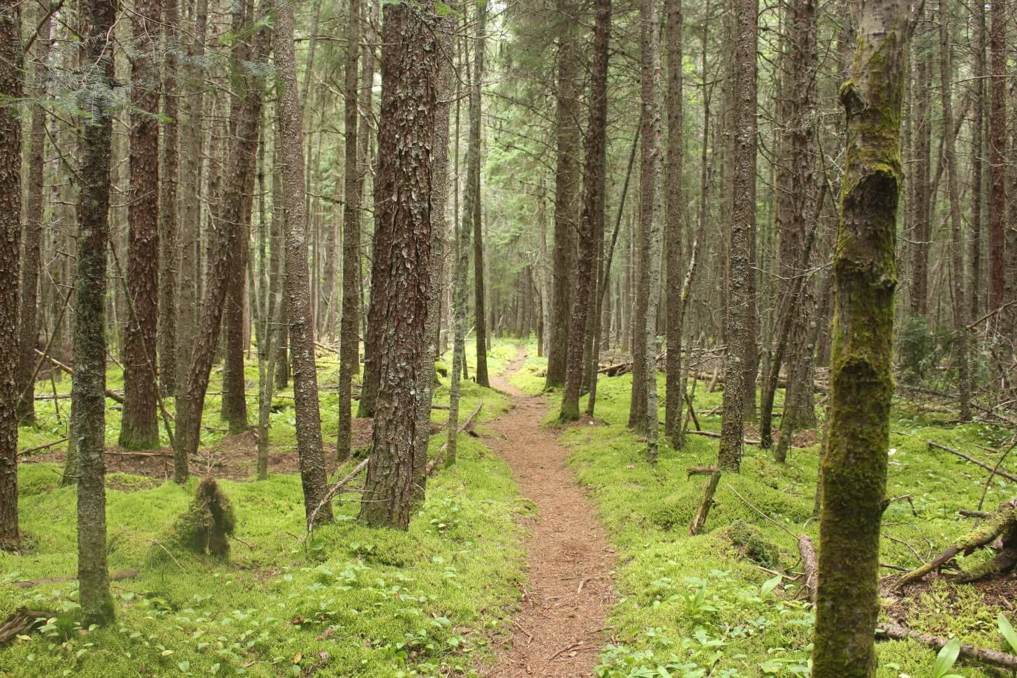
Leisurely meandering its way back into the forest, the trail caressed our feet with a carpet of thick green spongy moss. Small inland lakes and waterfalls seemed to greet us around every bend.
Crossing through a beach strewn with enormous driftwood timbers, we learned to step lightly as the log drivers of long ago must have done.
And finally, as we approached the coast, the trail reluctantly surrendered to the ancient, rugged geology of the Canadian Shield and the tenacious Jackpine.
If there is one tree that reflects the spirit of the wilderness and the rugged beauty of Northern Ontario more than any other, it would have to be the resilient Jackpine. One of the hardiest of the pines, its long needles, flexible branches, rough bark, and long stringy roots can withstand freezing winds, blowing ice and snow, drought, and even forest fires. It can grow on hilly, rocky terrain and sandy soil. It has learned to adapt and survive in its harsh environment. It is a real Canadian! It has become our favourite tree and a symbol of our adventures in Ontario’s north backcountry.
Member Exclusive
A Premium or Unlimited Membership* is required to view the rest of this article.
* A Basic Membership is required to view Member Q&A events

Discussion
Become a member to post in the forums.
Companion forum thread to: Pukaskwa National Park: A Journey Along the Coastal Hiking Trail
Following a memorable trip along Lake Superior a year ago, the author returns for another adventure filled with solitude and scenery.
Great trip report. We were there 18 months ago.
Is that a ZPacks Duplex tent in the photos? What did you think of it? It’s on my short list of perspective tents to replace our Hexamid Twin. My wife and I have agreed that the Hexamid is too cramped for two, especially when wet weather rolls in and hangs around.
Personally if using it all the time for two people I would prefer a triplex. I have used my duplex with a second person and if you prefer wide 25+” sleeping pads it just does not work well. Normal ones would work ok
Nice trip report.
And yes, I agree that a triplex is just right for two adults to be comfortable. It offers room for gear or the freedom to pitch it high without losing too much floor space.
I never thought of doing an out and back on this trail. Certainly saves on the ridiculous water taxi fee. Must plan this for next year. I have done the superior coastal trail so know the boulder beaches well.
We use NeoAir XLite pads, but I have noticed that both the ZPacks Duplex and the Six Moon Designs Haven tarp (with inner net) (both shelters come in Cuben) have floor widths of about 44″.
By contrast, the Six Moon Designs Lunar Duo has a 54″ wide floor and the TarpTent Stratospire 2 has a 52″ wide floor.
These seem much more reasonable, but are significantly heavier due to use of Silnylon instead of Cuben. :-(
Making the leap to the ZPacks Triplex seems excessive. That thing has a lot of lines to guy/stake out, and they increase the “footprint” of the tent significantly.
If only the Stratosphire came in Cuben…
I *love* the silnylon version but the weight is too high and there’s the whole sagging thing in cold/wet.
But Cuben! Yes.
Alas, though, Tarptent has a vision that works for them and it doesn’t involve Cuben. I do have to respect that. It keeps their focus.
But…Oh Henry! Pleeeeease give us a little CF love :D
Nice trip report. Always great scenery and the chance to meet nice, interesting people!
Just to confirm yes this is the ZPacks version of the Duplex shelter. Did a ton of research of reviews online for one of the most important pieces of backcountry gear, although it is a bit on the pricey side Cuben Fibre is totally the way to go for UL, keeping the elements out, drys very quickly, fits two Exped 25˝ width mats with plenty of head space for extra stuff, ease of entry/exit and just plain ease of setup/takedown. What more can you ask for? Just an example, on one particular Hot extremely humid weekend trip over the Summer we ran into a huge localized thunder storm where we had to make a very quick emergency pitch, the locomotive sounding wind, heavy rain and thunder raged all around us for easily an hour or more and was never more terrified for our lives but that just over 686g all inclusive 1 piece shelter including stakes, hiking poles as supports extra, held up incredibly well and most importantly kept us dry. (heard there were reports of tornadoes that had touched down in the area after. Yikes!!). Everyone may and will have differ of opinion but for us it’s exactly what we need for 3 season UL use especially with the variant weather in northern Ontario.
BTW This Pukaskwa trip was the most awesome and beautiful adventure to date with Leanne and can’t say enough about her… She’s a tried and true adventure machine. Let’s just say I’m a very, very lucky guy! :)
Greeting from one of the Kitchener-Waterloo group. Your trip description just gave me a flashback. It really is a special trail and we felt lucky to hike it as well.
Good luck on future travels, hope to bump into you again. Feel free to look us up at http://www.meetup.com/KW-Backcountry/
Yes Jeff it is a Zpacks duplex. See Stephen’s comments below. Stephen’s the gear junkie out of the two of us, but from my perspective, it’s been spacious enough for both of us, light, and more than sufficient to protect us from the elements.
I did Pukaskwa the week before you guys and Lake Superior PP last year as well. Are you following me???
Anthony: well maybe we are following you, but mostly, Stephen and I are just trying to experience all the beauty we have right here in our home province of Ontario and to share our journeys and love of backpacking so that others here at home, across Canada, and around the world will be able to see the rugged wilderness we are so fortunate to have right in our own backyard.
Some of next year’s plans include completing the Ottawa Temiskaming Highland Trail starting from Temagami. We did 4 days here this past summer and want to go back and do the entire trail.
Also wanting to do Heaven’s Gate on the LaCloche Range, as well as some possible out of province treks.
So many trails, so little time!!!!
If you want some additional info on heavens gate trail or a set of gps tracks let me know. Have done that one a couple of times now and know that there is not a lot of info on it out there. Also have a couple of photo albums I could share with pics so you can see what you are getting into. Would recommend doing it in late sept/early October so you can see th fall colours and there will be basically no bugs
Gunshot: a hefty branch getting snapped during a stormy night might sound quite gunshot-like. The only way to really distinguish a gunshot from other noise is hearing the supersonic pre- or after-“bang” (according to your position relatively to the gun and the path of the projectile). This applies to rifles, where the projectile usually travels with supersonic speed, shotguns are a bit slower but the pellets apparently still travel supersonic. And: no one in his right mind will hunt during a stormy night. Chances for a miss outweigh a hit by far. Chances it was a snapping branch outweigh here all other possibilities…
Nice report! Cheers, Urs
That’s awesome Bayden, Thanks for the tips and we’ll definitely be in touch.
Ashley, just checked out your web page looks like you guys have a lot of fun! we’ll be in touch!
Leanne – now you’re scaring me. I’m doing the Ottawa Temiskaming Highland Trail next year as well!!
We must have the exact same bucket list!
I may pm you for your insights from your four day trip last year if that’s ok with you?
Colin, here’s another option if you don’t want to water taxi or do an “out and back” :)
http://backpackinglight.com/forums/topic/78225/
Most excellent! I just today got back from 4 days along Lake Superior (Pictured Rocks Lakeshore) and I simply love the topography, flora, and fauna found along the lake. For my next summer trip I was heavily considering somewhere in the Wind River Range, but being from Wisconsin, I’ve probably changed my plans because of your trip report.
The Pukaskwa is closer for sure, and having a certain affinity for Superior, it calls to me. Thank you for putting together a great report with pictures that make me go, “Ooh, I wanna go there!”
Edit: Dan, your expedition-style version of this is ridiculous. In a good way. Fecking fantastic.
Edit #2: Merry Christmas, y’all.
Anthony- please by all means go ahead and pm me or Stephen for more details about the Temagami trail. It was challenging and beautiful> you’ll love it!
PM Sent.
Very nice Trip report/ video. Thanks for sharing!
What a great trip report! As a former Michigander who lived in the UP for a bunch of years during college (Go Huskies!) I absolutely fell in love with Lake Superior and the landscape up there, though I’ve only seen it on the USA side. I keep seeing these amazing places on the other side of the border, like your photos and report of Pukaskwa NP, and my Canadian-Superior bucket list keeps growing. Thanks for introducing me to this new place. Someday I’ll get up there and check it out.
Your photos are great and made me antsy to get back up north again, especially the shots from the cliff of the lake and rolling ridges (Day 4) and the foggy, rocky coast (Day 7). Again, great read!
Thank you Stephen and Leanne for sharing a fantastic trip report, which I’m still finishing. It’s hard putting down a good trip report mid-article late night.
The Ms. and me have a Duplex/Triplex on the UL shelter short list and we wanted to ask – understand that two 25 in. pads will fit in the Duplex, but what happens to the bathtub floor? Does it deform or put the seams under extra stress? Do the tub edges get pulled down very low? If the shelter is listed by Zpacks and all the reviews I’ve read at 45 in. width, that extra 5 in. has to come from somewhere.
Also when you want to batten down the hatches in high winds, can you get all the edges of the shelter flush or nearly flush to the ground?
Become a member to post in the forums.