I’m not aware of a declination adjustment on the Clipper. I carried one on the JMT because I knew navigation would not be a challenge but I like a baseplate compass that is not attached to a strap on most trips.
Topic
smallest compass w/magnetic declination adjustment?
Become a member to post in the forums.
- This topic has 55 replies, 17 voices, and was last updated 7 years, 7 months ago by
 .
.
One can always use magnetic north as the map reference datum and not worry about declination…. maybe pencil in a couple of magnetic north lines on the map to assist orientation.
Although in the dense green thickets I usually just click on Maprika and look for the throbbing blue arrowhead. :^/
“I’m not aware of a declination adjustment on the Clipper.”
You can rotate the bezel on the clipper. Rotate it and set the declination to line up with the little triangle on the edge. Then use it with the north pointer pointing at the triangle and you’ve adjusted for declination, more or less.It’s not a precise adjustment.
“My own experience with one of those ‘mini’ compasses is that they are rather tricky to use.”
You won’t want to rely on this thing to navigate cross country in the desert and find that all important spring. However, it works just fine for gross navigation – on trail, +/- 5* or so, making sure you don’t get turned around, etc. This one is better than probably most the “mini” compasses that I’ve seen, but that’s still what it is.
If you’re looking to do some real navigation, this isn’t the right tool for the job.
Hi Lee
Agree. This is how we usually navigate:
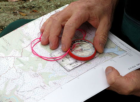
The compass orients the map. Works for us.
Cheers
Re: “Was explained to me that the bubble forming wasn’t air leaking into the compass but gas coming out of solution at the lower atmospheric pressures associated with higher altitude.”
My trips are usually in the Rocky Mountains or New England in the USA. Have tried all the major brands, including all those mentioned above. They are good until they go from NH to CO by auto, and the bubble appears, sometimes in CO, but often not until I return to NH. More trips enlarge the bubble until it interferes with use. Surprisingly, the only compass in recent years that got through a couple CO hikes unbubbled was an inexpensive Coughlans, but it eventually succumbed also. Kind of a bummer, because the hiking in CO is often off of maintained trails, and the compass gets used repeatedly. Years ago, the bubbles were not a problem – sigh, just another example of our brave new world of consumer goods.
Will try the Brunton mentioned above. Don’t expect much, but maybe? Want a smallish compass also, as it is constantly coming out of and going back into a zip pocket. Just studying the map occasionally is enough to know what direction I should be heading. Stopping to find a flat place to orient the compass with the map, as shown in all the ‘how to’ manuals, is not essential and would be a nuisance.
As for the declination adjustment (not just a “scale”:): When constantly taking headings to stay on course, it makes life way easier. Won’t buy a compass without one, except got fooled once by a rotating bezel.
Yes, wish someone would make a high quality small and light compass that resists bubbles and has a declination adjustment. But no, will not be putting compasses in the (toaster) oven, It is easiest before each trek to just buy a small and light compass that resists bubbles for a while anyway. Have quite a collection of bubbly ones, and should throw them out. Great idea for a thread. Thanks.
I wonder how the mfr manages to fill the module without any bubbles? If I knew that, repairs would be kinda simple.
I know how they keep the top/lid on the module: there is a wave spring between the top and the base which pops into shape when the top is pushed on. How to get the top OFF without trashing the spring … seems difficult.
I suspect the mfrs do not ‘repair’ your compass if you send it in; they just replace it. At a few dollars for the unit (warehouse/mfr cost, NOT the retail price), it is simply not economic to do otherwise. (You can get two of those ‘mini-Bruntons’ for $1 on eBay. Authenticity NOT guaranteed!)
Cheers
I keep one of those Suunto Minis clipped to one of my trekking poles’ wrist straps. Checking my bearing is as easy as checking the time. As others have said, you wouldn’t want to do any serious navigation with it, but for getting through short wooded sections, hitting a targeted “fence” on overcast days, etc., without getting turned around, it’s a marvelous little tool. Yes, it’s a bit futzy about the level, but who cares–getting it flat is quick compared to pulling out a real compass when I’m up to my shoulders in willows.
The Suunto M-3, 47 grams, is the smallest name brand compass that I know of that has a set screw for adjusting the declination. The Suunto M-2, which is a mirrored sighting compass, weighs 74 g by contrast, about a 1 oz difference.
I used to do the add and subtract thing when I was in the army and found it an annoying pain even though the army thoughtfully provided printed instructions in the margin of every map. I love declination adjustable compasses. Just so easy.
HJ
Good point about weight, this being BPL after all… the TruArc3 stock (with lanyard) is 36.9g
It doesn’t use a geared screw and separate scale for setting declination like the Suuntos but rather simple friction between the bezel and the needle housing. Maybe a teensy bit less precise altho plenny good enuf.
Sam, I had not noticed that pattern for bubble development, so that is some interesting information… back in the ’90s – early 2ks the MC-2G in my photo above went back and forth quite a few times from sea level to 10-14k feet (plus the ups and downs of airline baggage hold pressure, lol) and did not have a problem. The Brunton has only been to 5-6k feet on a handful of occasions, and it’s less than 2 years old.
Thanks for the links about navigation techniques Nick, Lester. I really need to learn more about this. GPS navigation makes one lazy about low-tech but more dependable methods.
David, last fall while bike touring, I was passing through the Alberta Badlands, and stopped to set up a photo of the strange landscape. I sat down on a bank covered with tall grass. The grass nicely hid a grove of cacti. I was glad I had a small signal/shaving mirror along. A piece of emergency blanket wouldn’t quite have cut it! I might have been able to make do with the reflection from the screen of my camera, or maybe my cycling helmet’s visor, but both would have prolonged the task.
Roger, I had a compass leak on me a short while ago, and it smelled like a snow globe that I broke when I was a child. Apparently snow globes contain water and antifreeze. It is a little baffling that I smelt it, because antifreeze is odourless. Yet more baffling is that people claim to be able to smell leak of coolant in their cars. In short, I’m not sure if it’s what’s used, but try a mixture of glycerol or ethylene glycol and water. You should be able to adjust the viscosity by adjusting the water:antifreeze ratio. If you make a note of what concentration you started with and what proportion you mixed, you could then find a reference table with your compass’s freezing temp. (If you’re into winter navigating, that is!)
Mineral oil might seem appropriate, were it not for its too-high viscosity, but it also freezes not very far below 0ºC. (That is why, of the two main types of hydraulic brake fluid for bicycles — mineral oil and DOT fluid — you must choose DOT for cold climates.)
Anti-freeze? Hum – OK, thanks. Must try it some day.
Cheers
I really need to learn more about this. GPS navigation makes one lazy about low-tech but more dependable methods.
Brushing up and practicing wilderness navigation skills every few years is important and also quite fun. Same is true for crevice rescue (if applicable) and wilderness first aid. Find some hiking buddies and make a half day event out of it. Try out some different compasses and see for yourself their pros and cons.
I wonder how the mfr manages to fill the module without any bubbles? If I knew that, repairs would be kinda simple.
From a perusal of other [marine] compass discussions, I’ve seen mention that the fluid should be held under vacuum for a time to remove dissolved air. Filling while cold could also give you an edge on the thermal expansion side of things.
The fluid itself probably varies by manufacturer and use; odorless mineral spirits, mineral oil, alcohols+water, even vodka, have been mentioned in various places. One suggestion was that if you’re just topping it up, fill a few tubes with candidate fluids and add a drop of the original fluid: pick the one that mixes cleanly (same refractive index, etc.).
-J
I really need to learn more about this. GPS navigation makes one lazy about low-tech but more dependable methods.
Maybe try navigation using map and compass with an occasional peak at the GPS to confirm that you are where you think you are. This approach works for me, at least.
I do like to plan the next day using GPS (Gaia) because I can toggle through different map types, plot routes with distances and stuff like that.
I find it is far more beneficial to draw magnetic north lines on your maps rather than deal with a declination adjustment or remembering to add or subtract. You to take readings on the fly in the field without having to orient your map. That is especially helpful when it is raining or windy.
“draw magnetic north lines on your maps”
Do that somewhere on the map. Because we all cut the margins off, right? Because this is BPL. Transfer the scale from the legend to the map itself.
The other weight-saving technique is to cut out the lakes. The lakes offer no information, since the shoreline shows their elevation. Cut them out and save that weight.
P.S. I’m serious about the first suggestion.
So what exactly do you find repugnant about drawing magnetic north lines on a map?
Hi Will
Well, I have over 50 maps, and probably over 20 photocopies of each one, so the labour involved would be not small.
Cheers
I have a few maps myself. The time involved depends on how you produce the magnetic north lines on the map. The old-fashioned way is to use a protractor and a three-foot ruler. You could do each one as you need them. A map takes no more than a few minutes. You can also use mapping software which you can print to a PDF. You can create the lines with the computer and store it so you do it only once.
The people I know in search and rescue, including my group, use this method. Instead of using a geographic meridian reference you can forget the edges of the map that run geographic north and south because your map is now transformed to a magnetic meridian reference. That is what your compass cries out for.
For a four-minute investment, you have a map which is significantly faster and easier to read in the field.
To each his own.
I also mentioned this above (using magnetic north as datum) and while there is absolutely nothing wrong with it, virtually all maps are printed with the margins aligned with true north, thus making it easy to line up the compass’ base plate anywhere along the edges of the map.
Of course one has to be careful not to be thrown off by UTM/USNG grid lines which can vary from true north by a few degrees east or west near the edges of a zone.

Just a reminder for those using maps from free sources…. Magnetic north is not constant. It varies a tiny bit each year. So if you are using an older map with declination printed on it (which you shouldn’t in the first place, but free maps are cheaper than not-so-free maps), be sure that you confirm the declination adjustment for the location in question.
The current BSA handbook teaches the method of drawing the declination lines on the map. While a pain in the posterior, it is a great way to help teach true vs. magnetic North to Scouts in a way that is more easily remembered. I have observed with Scouts that there is a big difference in understanding and retention. Seeing things visually sometimes helps spur retention.
I think somebody noted this (or something similar) earlier.
Plenty of current declination sources online… this one might’ve been linked above. Pretty easy just to plug in the Zip Code!
As I am a visual artist, in teaching or using declination I find it most useful to visualize the physical situation: the world is a ball with an axis and an absolute top. There is a magnetic spot some distance down from the top, and when I look up at the top, the magnetic spot is not in the line of sight, it is off to the right or to the left. Generally in these parts an average of 12 degrees. Unless you are doing compass games finding small objects in the middle of the desert, that is way accurate enough in the Sierra because then you compare the topo to what you see. That is why I am comfortable taking the small Suunto Clipper (and I almost never use it.)
Where I hike/backpack/bushwhack it is densely vegetated, with lots of blow down, making movement slow. One is almost always under the canopy of trees which makes line-of-sight travel difficult. Often, you need to go off your projected course particularly when storms have caused marshy areas to be much larger than what otherwise appears on the map.
Shooting azimuths and thereby triangulating your position only occurs if you find your way to the top of a mountain or hill.The line of sight is very limited.
Compasses and declination aside, in dense cover, you had better be able to know how to carefully read a topo map, and know where you are on it. You also need to be able to navigate using just map contours, terrain association and observation.
Become a member to post in the forums.
advertisement
Garage Grown Gear Hidden Gems
Discover under-the-radar ultralight gear from small brands.

