I’d love to get back up into the Sierra very soon, but I just don’t know how to plan around what I see on https://fire.airnow.gov/. Smoke everywhere.
How do you all plan trips in the Sierra during times like this?
Topic
Become a member to post in the forums.
I’d love to get back up into the Sierra very soon, but I just don’t know how to plan around what I see on https://fire.airnow.gov/. Smoke everywhere.
How do you all plan trips in the Sierra during times like this?
From what I know, there are two rather large fires: Creek fire near Shaver lake (started today but growing fast) and the Slink fire near Monitor pass. Also two smaller fires in Yosemite both near Lukens lake in remote areas not close to trails or structures that are being allowed to burn. There could be others.
Of course smoke from the recent Bay area fires, in particular the LNU complex and SCU complex might make it up there too.
We are not even in the fire season for this part of California yet…….
I check purpleair.com and airnow.gov but there are very few sensors up near the Sierra.
More bad news
Everything above Prather on Highway 168 has been evacuated. That means Florence Lake, Thomas Edison, Kaiser Pass, etc. We were there this morning…bailed on a trip, trapped when they closed 168…now safe and in our way home. It’s not a normal year, whatever normal means
Paul—I’m sorry your trip was canceled but glad you got out OK!
Is anyone planning on a trip to the Sierra in the next few weeks? Or are you just waiting till the smoke dies down?
I may go up and do some trail work later this month…depends on the weather and, as you suggest, the fires.
There is pretty much nowhere in the Sierra I would go at the moment. Even if you can avoid feeling ill, the ugly light and overall drearyness is just too depressing. But conditions can and do change rapidly.
I just got back today from a trip in Yosemite to Clouds Rest. Yesterday as we were atop Clouds Rest, the smoke started pouring in from the Creek fire (Shaver Lake). The sky was reddish purple, it looked like dusk at 3pm, and it started raining ash like snowflakes. I kept having the feeling I needed to take off my sunglasses.
This is not a time to go. Thank goodness I’d brought an N-95 mask.
It was worse than the pictures look.
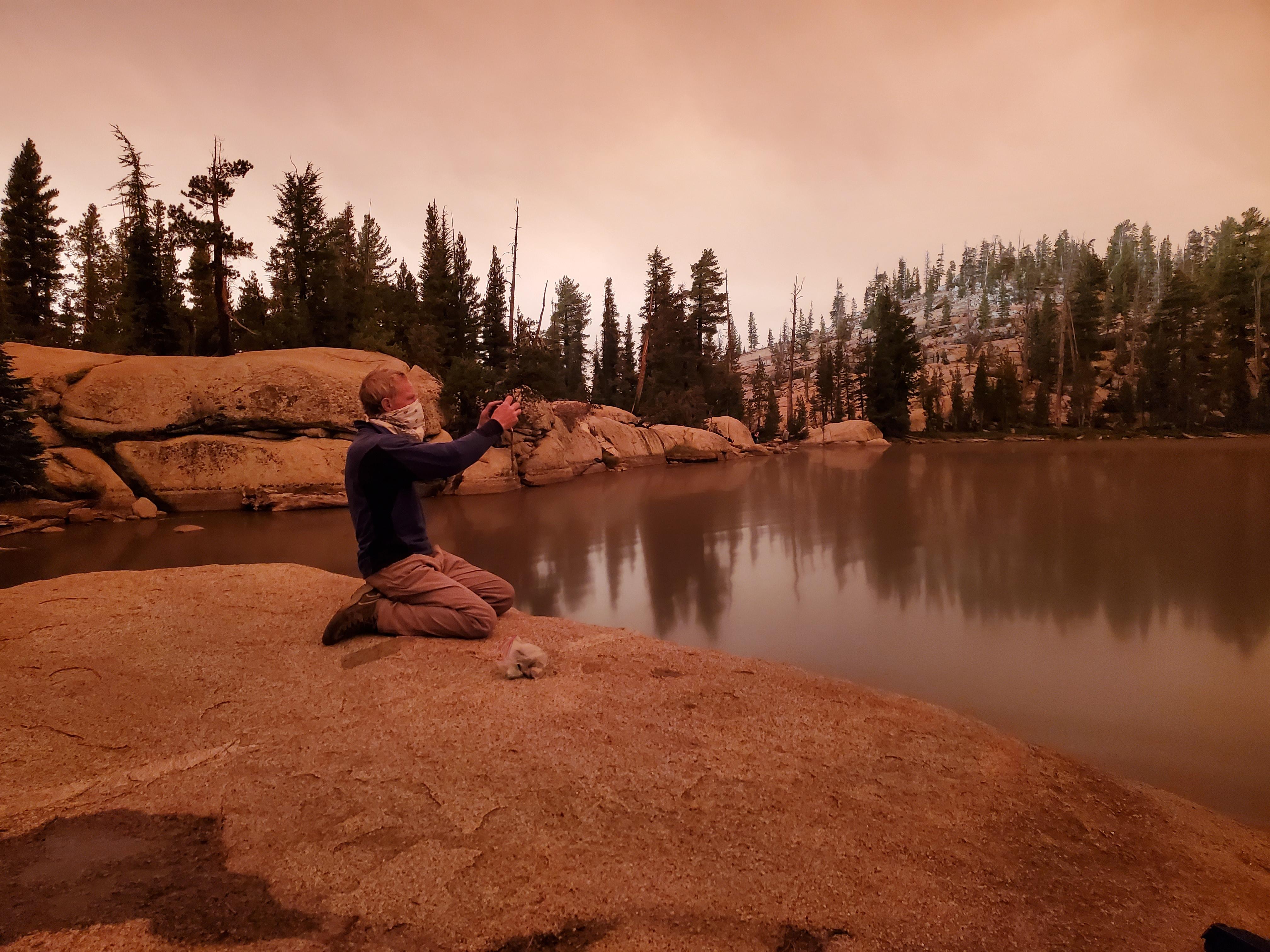
That granite is gray, not brown…but the sky was so dark everything was reddish.
Yikes! Thanks for the field report, dk. I think I’ll wait till the smoke clears and maybe go to a lower elevation place (to avoid possible snow) in a while.
How about the eastern side? Any body been up there or to Mammoth? I am going up to Big Pine Lakes out of Big Pine (south of Bishop) tomorrow?
Bishop had air quality index (AQI) in the 400s this weekend. Maybe south of it is better, I don’t know. The direction of the wind where I was seemed to be somewhat northward.
Bishop was recording the worse AQI index I’ve ever seen yesterday–over 450.
Here in south-central Colorado the visibility has been as low as 3 miles. (Sept 7th, ~2 pm)
The closures include Angeles National Forest, San Bernardino National Forest, Cleveland National Forest, Los Padres National Forest, Stanislaus National Forest, Sierra National Forest, Sequoia National Forest and Inyo National Forest.
That means all those hikers we met on the JMT and the PCT are now SOL.
FYI: While Bishop AQI of over 450 is terrible, I’ve regularly seen values above 600 and a couple times over 700 on PurpleAir.com, close to the SF Bay Area wildfires over the last few weeks.
Since the EPA PM2.5 chart stops at 500, those values were literally off the charts. Somehow firefighters dig lines and work hard on other tasks in that air. Can’t even imagine carrying a pack uphill for miles.
I wouldn’t be surprised to see similar values near some of the new wildfires. Assuming the sensors have power and Internet access.
Looks like most of those forests and parks are off-limits now, as they were or still are in the Bay Area.
— Rex
How bad is it in Napa?
At 8 a.m. this morning, I tried to take a photo of our backyard. On the one hand, it looked as if it were snowing…as ash fell from the sky at a steady pace. But it was difficult to capture the scene on my camera. because it was so dark that the camera’s auto-flash deployed.
Yes, in what would normally be broad daylight, any outdoor photos required a flash. And that flash lit up the flecks of ash falling from the sky. It was so bad that when I got up this morning I thought I had misread the clock, because it was dark outside…
Absolutely apocalyptic.
Paul—Same light here in Berkeley. Dark!
Yup. Normally it’s very bright in our house this time of morning, now I’d have to turn on a light to read anything. The sky outside looks like it did in Yosemite a few days ago with the smoke from the Creek fire – everything is sepia tones.
Back in Chico from Redding this morning. The Bear and August Complex fires have the valley in darkness from Oroville to Redding. Air around Shasta and further north looks fairly decent. Trinity Alps are a bit hazy and oddly sporting a touch of fresh snow.
It is just nasty outside. Stay home safe.

This is from our balcony just now.
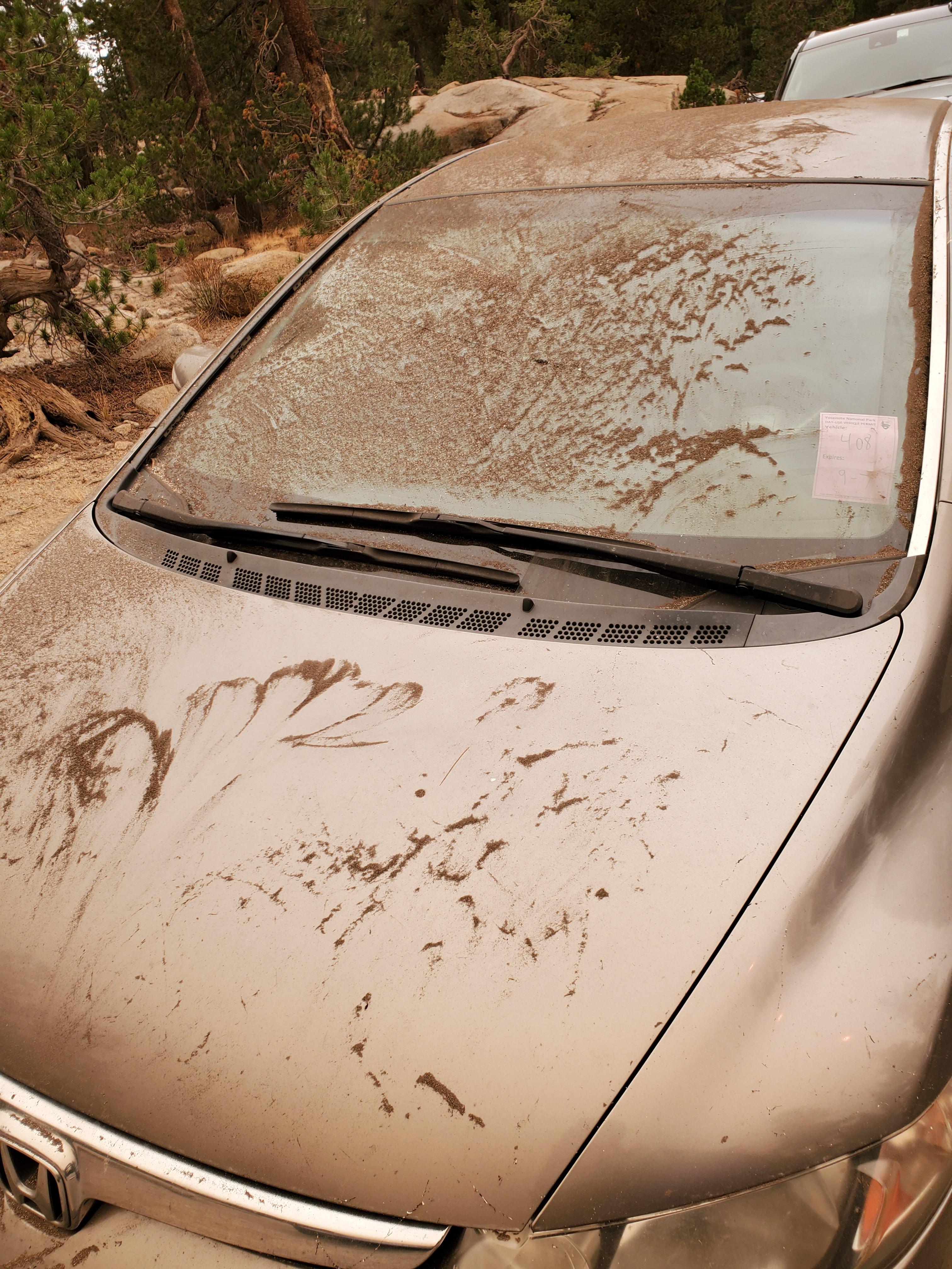
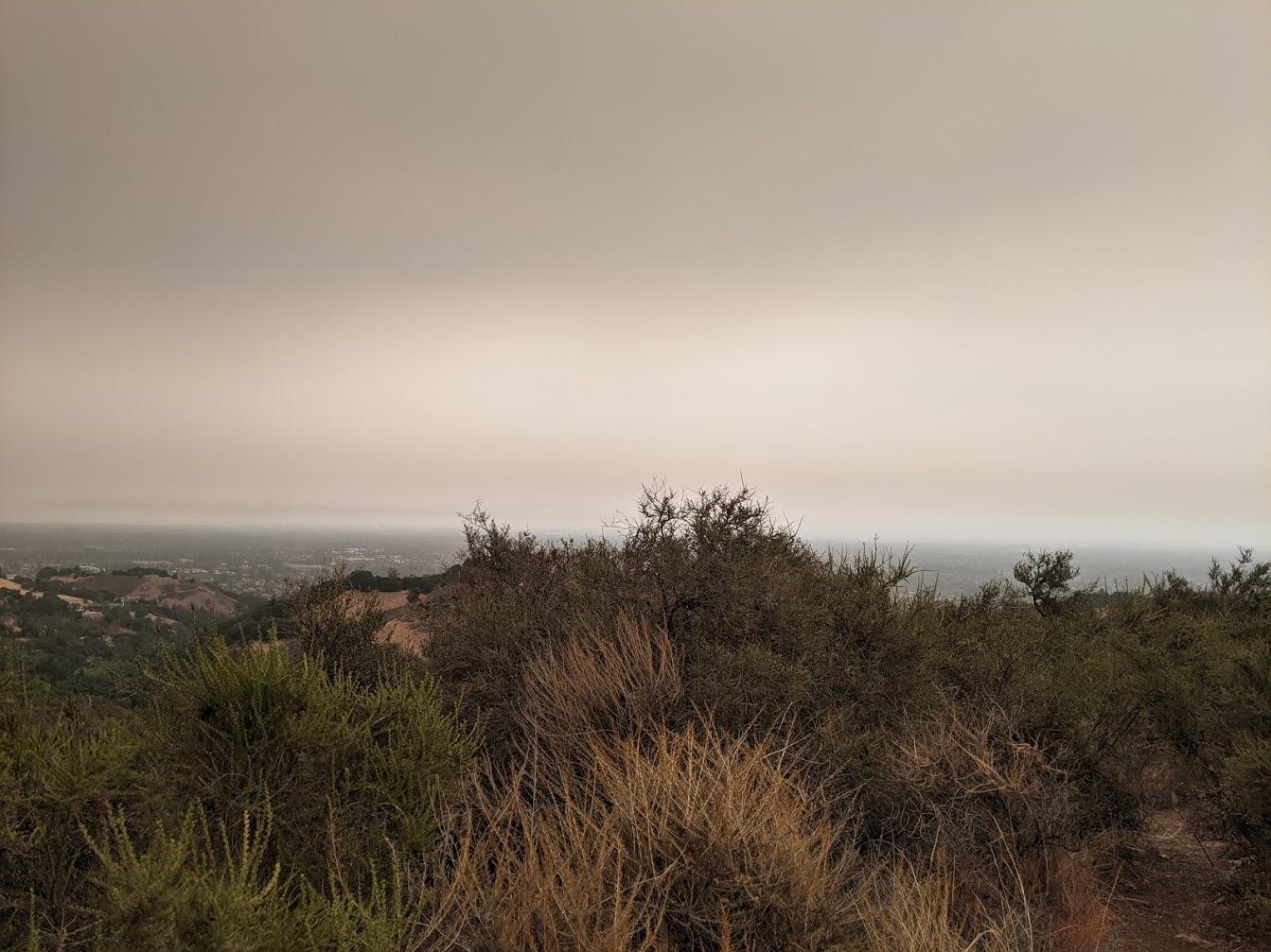
Picture taken at 11 AM this morning in the South Bay hills near San Jose. The dark clouds are smoke from the fires north and east of here. Strangely the surface level air quality is not bad and there’s no smell of smoke. Just a dusting of ash on cars parked outside.
My wife and I were comparing today’s gloomy darkness and recent events to Mordor, a land of death and destruction with an all-seeing evil eye in fictional books and movies.
Or were they prophetic?
— Rex
That’s precisely what I was thinking about the Creek fire smoke we saw in Yosemite this past weekend, Rex.
CalTopo added live satellite imagery, which is very helpful for monitoring smoke.
@feetfirst: Is that only viewable for paid accounts?
Become a member to post in the forums.
 New Ultralight ShelterFreestanding silpoly shelter for lightweight adventures.
 Loading...