Topic

How and what is your method for getting forecasts for a specific area?

Viewing 21 posts - 1 through 21 (of 21 total)
Don Burton BPL Member
PostedJun 25, 2016 at 4:44 pm

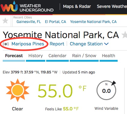
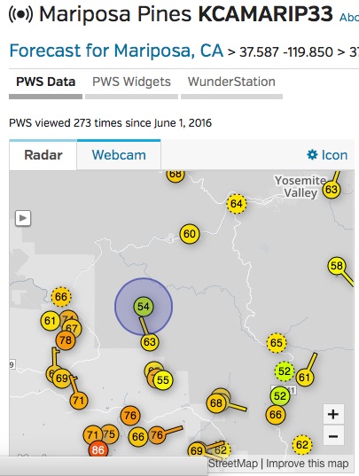
How do you specifically get a weather forecast before a trip? Websites? How you locate the area on said website? Just type in name? Enter coordinates? Where do you get your coordinates? Etc?

I just don’t have a method that I feel good about. I feel like it’s different every time. Please describe like I know nothing about this, which is probably not far from the truth. ;-) I just find that many people inadvertently leave things out because they assume you know or it slips their mind because they already know.

I’m leaving for Cottonwood Lakes on Wed June 29.

Valerie E BPL Member
PostedJun 25, 2016 at 4:58 pm

I usually use NOAA (http://www.noaa.gov/).  I type in the nearest town, then I scroll down to the map (right hand side) and move the map around until I get the place I want; I click on that place, and the forecast is given for that area.

Don Burton BPL Member
PostedJun 25, 2016 at 6:11 pm

Valerie,

Thanks. I typed in “Lone Pine, CA” in the search bar. I found the area I’ll be hiking but when I clicked on it for a forecast a page showed up saying, “A point forecast is unavailable for the requested location.” The nearest forecast I could find was for Lone Pine which is about 6500′ lower in elevation.

I went to the National Weather Service site and did the same thing. When I clicked on some points it said the elevation was 6690′. I tried clicking on some nearby areas and got strange elevations from 410′ down to 80′. Very confusing.

Any ideas?

Arthur BPL Member
PostedJun 25, 2016 at 6:12 pm

I agree.  In my personal opinion, the commercial weather chanels inflate things to make a good story to sell ads.  They make the upper limits of probability the norm.  Always higher highs, lower lows, more wind, rain and snow than NOAA.  NOAA does not get paid by dramatics, but the others do with higher ratings.

Arthur BPL Member
PostedJun 25, 2016 at 6:14 pm

if you want forcasts that account for elevation, try this.  http://www.mountain-forecast.com/


Jeffrey Hlavac BPL Member
PostedJun 25, 2016 at 9:54 pm

Hi Don,

My experience is that the more remote you go from the actual reporting stations that support the weather data, the more inaccurate the weather forecasts will be so plan accordingly. I just got back from a trip to the remote Steens Mountain in SE Oregon and the weather forecast on weather.gov using the pinpoint feature was off by 20* for it’s low’s. It forecast lows in the 50’s and we had water bottles with ice in them this morning.

Don Burton BPL Member
PostedJun 25, 2016 at 10:05 pm

Thanks everyone. So as best I can tell, the Cottonwood Lakes are will have highs in the mid 50’s and lows around 50F next week. This doesn’t seem quite right to me. If anyone is kind enough, can you tell me what you find so I can confirm whether I did this correctly. Thank you

PostedJun 25, 2016 at 11:13 pm

Check this out: http://forecast.weather.gov/MapClick.php?lon=-118.21561336029744&lat=36.47949567868423


John S. BPL Member
PostedJun 26, 2016 at 3:25 am

Point Forecast: 11 Miles SW Lone Pine CA  36.5°N 118.21°W (Elev. 11129 ft)

Monday: Sunny, with a high near 75. South wind 8 to 10 mph.

Monday Night: Mostly clear, with a low around 50. Light and variable wind becoming north around 6 mph.

Tuesday: A 20 percent chance of showers and thunderstorms after 11am. Mostly sunny, with a high near 74.

Tuesday Night: A 20 percent chance of showers and thunderstorms before 11pm. Partly cloudy, with a low around 50.

Wednesday: A chance of showers and thunderstorms after 11am. Mostly sunny, with a high near 69.

Wednesday Night: A chance of showers and thunderstorms, mainly before 11pm. Partly cloudy, with a low around 51.

Thursday: A slight chance of showers and thunderstorms. Partly sunny, with a high near 69.

Thursday Night: A slight chance of showers and thunderstorms. Partly cloudy, with a low around 50.

Friday: A slight chance of showers and thunderstorms. Mostly sunny, with a high near 68.

Friday Night: A slight chance of showers and thunderstorms. Partly cloudy, with a low around 49.

jimmy b BPL Member
PostedJun 26, 2016 at 7:13 am

+1 on all the above but I build in at least a 10deg. buffer on the low end. We had mild weather reports for a trip to Virginia late this spring but temps went to freezing pretty quick. The few oz. of extra insulation were welcome. Mountain weather being what it is, most of the time I will plan for cooler weather with wind.

JCH BPL Member
PostedJun 26, 2016 at 8:44 am

Another useful resource is Wunderground.com. They crowdsource a lot of information from people who purchase and maintain their own weather stations, then stream the info to WU.

Search for a nearby location, then click the reporting station:


Zoom out on the map and select any of the nearby reporting stations:

You won’t get forecast information, but you can get valuable insights by comparing the historical information for each station, i.e., variations in high/low temps, wind speeds, etc.

jimmy b BPL Member
PostedJun 26, 2016 at 9:02 pm

+1 Weather underground.

I use that sight a lot. Especially for sailing. The wind forecasts, at least in our area. are very accurate. The history access is nice for checking what the recorded conditions were as apposed to what was forecasted. Only problem is remote areas/ higher elevations lack good station coverage so a little rough +/- to temps  is necessary.

Nick Otis BPL Member
PostedJul 11, 2016 at 10:23 pm

Don,

I’m a bit late to the party, and others have suggested weather.gov. I’ll just add that since I plan all my routes in CalTopo, I get my weather.gov/NOAA right from there by right-clicking. This way, I don’t have to search the weather.gov/NOAA/Wunderground map.

Viewing 21 posts - 1 through 21 (of 21 total)
Loading...