Guadalupe Ridge Trail – High Route Alternate

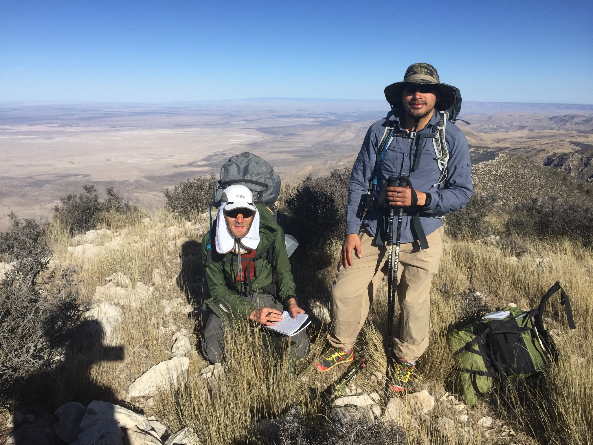
This report describes a modified version of the Guadalupe Ridge Trail in the Guadalupe Mountains of Texas and New Mexico. We did this trip over three and a half days in February, 2018.
The goal of this route was to traverse the range from start to finish following the crest of the range, so we could deep into some of the most spectacular and remotest sections of the mountains. We got a challenging trip with some of the best backcountry hiking in Texas and New Mexico.
There’s not a lot of information online about the Guadalupe Ridge Trail. And many of the trip reports about the Guadalupe Mountains say it’s hard to find good loops or thru hike for backpacking. With this report we wanted to share our experiences with the Guadalupe Ridge Trail for those considering hiking it. And for those with some comfort navigating off trail, describe how we got into the western ridge of the park that we thought was the highlight of the range.
Route summary and highlights
- Traverse the entire spine of the Guadalupe Mountains through Carlsbad Caverns NP, Lincoln NF, and Guadalupe Mountains NP.
- First two days on trail, last two days mostly off trail
- Climb the 4 highest points in Texas, in a single day
- End the route on Texas’s highest point, Guadalupe Mountain
- Follow a ridge that drops 4,000 ft to the desert floor below, with spectacular views in all directions
- Easy off-trail navigation and route selection because you almost always have a massive cliff to use as a handrail.
- Most off-trail is rocky terrain with interspersed grass and bushes. The pine forests are clear of underbrush and easy to navigate. A few sections with difficult bushwacking. Only a few steep off-trail sections that required scrambling
- Makes for a good long weekend trip since it’s ~4 days to complete
- Have to carry lots of water, and cache water, although there is one good spring on the route
We started planning this route about two years ago when looking at topo maps of Guadalupe Mountain and the surrounding area. We’ve been doing Andrew Skurka’s Wind River and Kings Canyon high routes in the summer, and we were looking for a similar experience that we could do in winter.
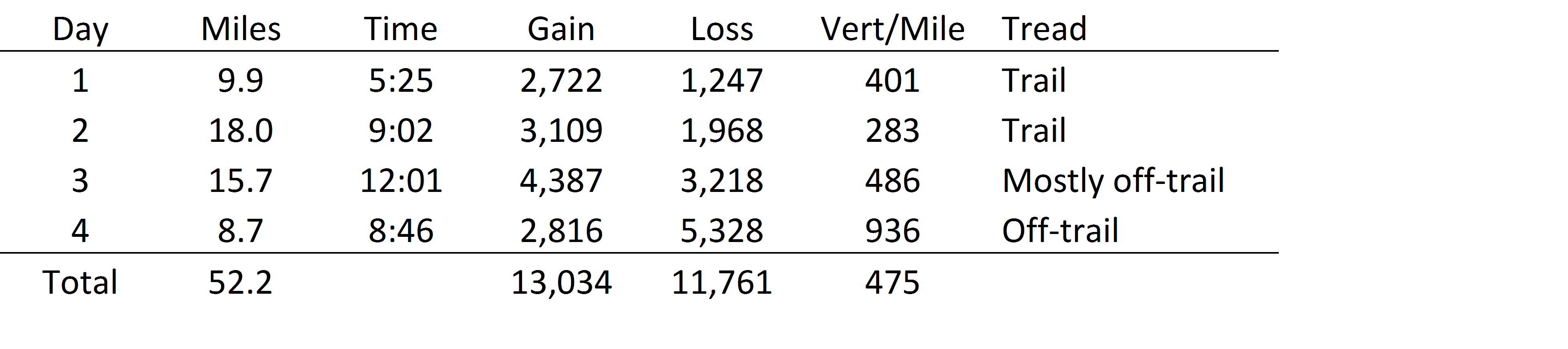
Stats
<table width=”510″>
<tbody>
<tr>
<td width=”64″>Day</td>
<td width=”64″>Miles</td>
<td width=”64″>Time</td>
<td width=”64″>Gain</td>
<td width=”64″>Loss</td>
<td width=”72″>Vert/Mile</td>
<td width=”118″>Tread</td>
</tr>
<tr>
<td width=”64″>1</td>
<td width=”64″>9.9</td>
<td width=”64″>5:25</td>
<td width=”64″>2,722</td>
<td width=”64″>1,247</td>
<td width=”72″>401</td>
<td width=”118″>Trail</td>
</tr>
<tr>
<td width=”64″>2</td>
<td width=”64″>18.0</td>
<td width=”64″>9:02</td>
<td width=”64″>3,109</td>
<td width=”64″>1,968</td>
<td width=”72″>283</td>
<td width=”118″>Trail</td>
</tr>
<tr>
<td width=”64″>3</td>
<td width=”64″>15.7</td>
<td width=”64″>12:01</td>
<td width=”64″>4,387</td>
<td width=”64″>3,218</td>
<td width=”72″>486</td>
<td width=”118″>Mostly off-trail</td>
</tr>
<tr>
<td width=”64″>4</td>
<td width=”64″>8.7</td>
<td width=”64″>8:46</td>
<td width=”64″>2,816</td>
<td width=”64″>5,328</td>
<td width=”72″>936</td>
<td width=”118″>Off-trail</td>
</tr>
<tr>
<td width=”64″>Total</td>
<td width=”64″>52.2</td>
<td width=”64″> </td>
<td width=”64″>13,034</td>
<td width=”64″>11,761</td>
<td width=”72″>475</td>
<td width=”118″> </td>
</tr>
</tbody>
</table>
Part 1 – Guadalupe Ridge Trail
We hiked north to south to get a couple of days of easier trail hiking first. The Guadalupe Ridge Trail gradually climbs from about 4,600 ft to 7,200 ft over the first 28 miles, with a total gain of 5,800 ft and loss of 3,200 ft. The lower parts of the trail climb rolling open hills covered in desert plants like grasses, cactus, and small shrubs. Above about 6,700 ft once you reach Lincoln NF the vegetation is mostly pine trees.

We started at the Rattlesnake Canyon trail in Carlsbad Caverns NP. Over 2 miles this trail drops into Rattlesnake Canyon, follows the wash, and climbs up to meet the Guadalupe Ridge Trail. It’s a nice alternative to starting on the ridge, but was a hard start with two days of water on our backs.

The trail follows an old jeep trail through Carlsbad Caverns NP that’s occasionally hard to see. Once it reaches Lincoln NF though the road widens to a true 4WD road that is still driven by hunters and others. We saw nobody until we ran into some ATV-ers at the end of the second day.
This range is notoriously windy. The area was under a “damaging wind” advisory while we were hiking, and the Pine Spring ranger station recorded gusts of 68 mph. The ranger station is at the base of the leeward side of the mountains. We were hiking and sleeping on the windward ridges, and we think gusts probably topped 80 mph. We used bivys for sleeping but none of us got much sleep in that much wind the first night. There were a few times when hiking on the exposed ridges that the wind knocked us over.
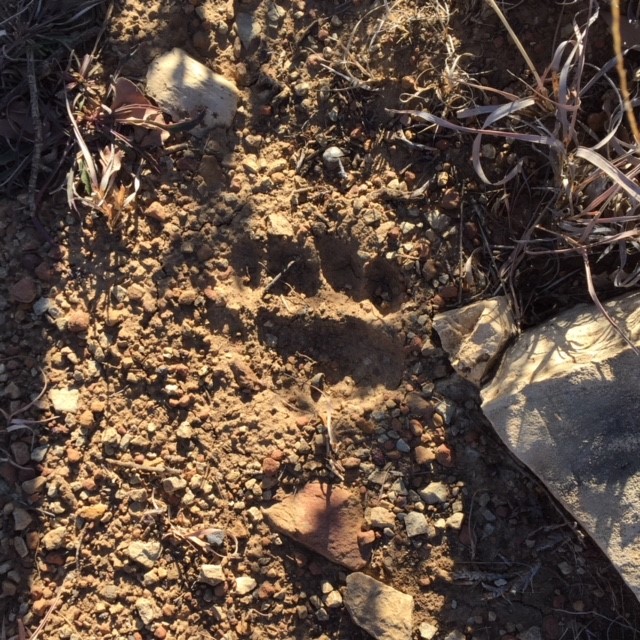
We thought this print might be from a mountain lion—it was as wide as our hand.

There are a couple of semi-reliable springs in Lincoln NF. We called the ranger station when prepping for the trip, but they said no rangers had been to the springs in over 6 months and wouldn’t confirm if there was water in the spring. We were glad we cached and carried extra anyway.
We spent the second night where forest road 540 meets 201. We’d cached water at a nice established campground there. it was nice to have more water than we needed.
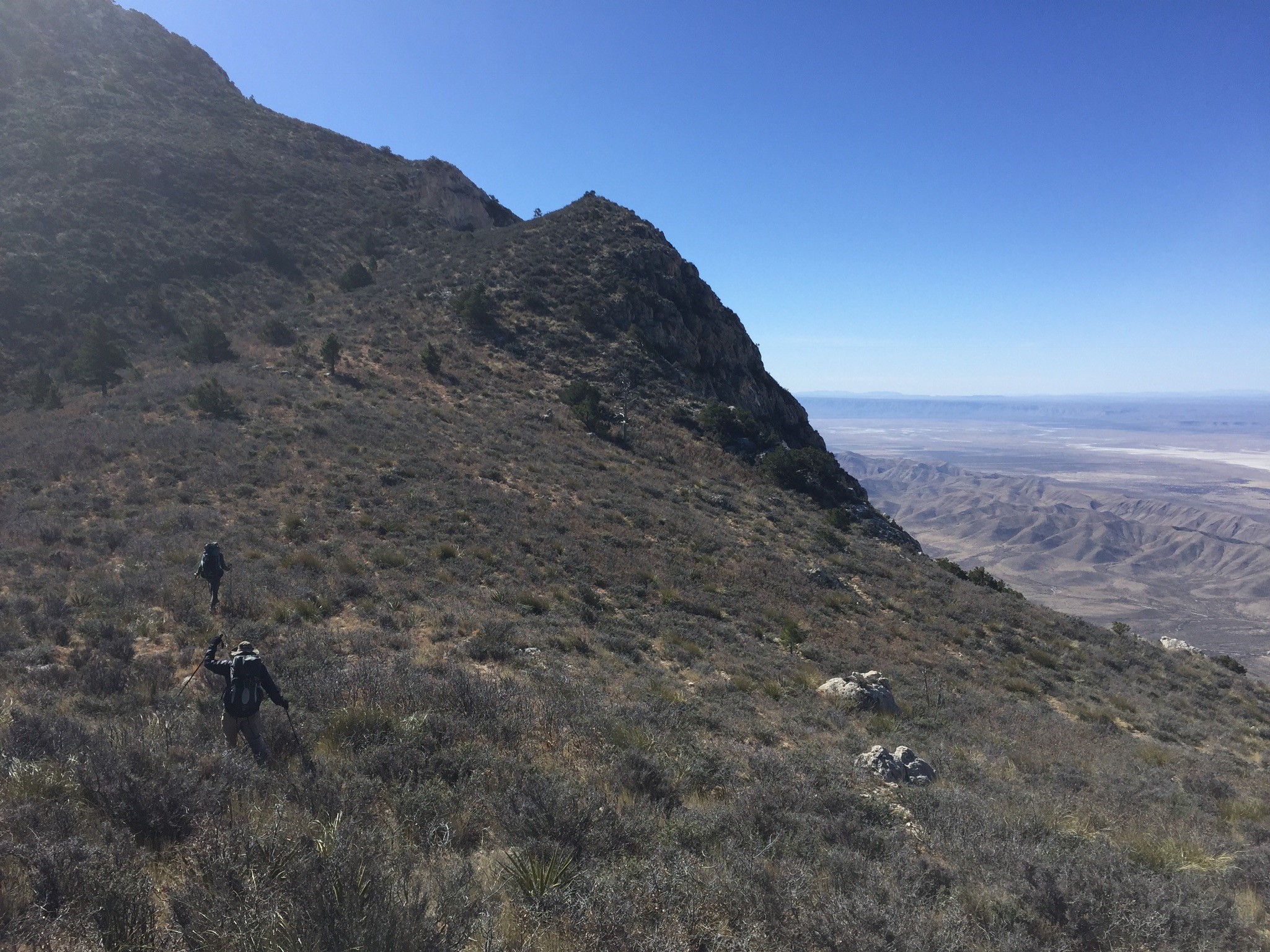
Part 2 – off trail
We left the main trail early on the third day. The Guadalupe Ridge Trail route drops from the crest of the range down the Camp Wilderness trail southeast to the McKittrick Canyon Ranger Station. Instead, we went southwest to the uppermost part of North McKittrick Canyon where we saw a herd of elk, then climbed up the ridge above Dog Canyon and followed it along the Forest boundary.
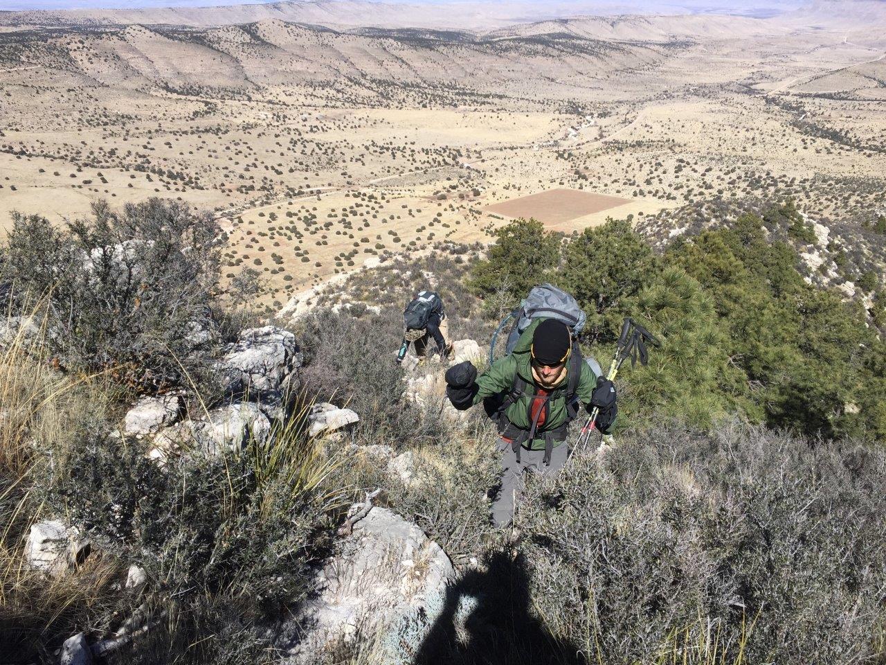
Carrying two days of water made the climbs pretty hard. Some sections were thick with creosote bushes. Look out for cactuses that hide on the ground. Yucca will give you a few good stabs too. But even these thicker sections were usually already carved with deer trails.

We followed the national forest boundary along the ridge for about two miles until we reached GMNP. We stayed along the ridge looking down onto the Dog Canyon Ranger Station for another 1.5 miles. We climbed up onto the south side of Pine Mountain and followed the spur up to where it joins the McKittrick Canyon Trail. This was the only section of the hike we had no prior information about other than the map, and were glad to prove it goes. It was only 6 miles but took us 7 hours to complete, and put us behind our planned time for the day. From there we followed trails to the Blue Ridge trail that took us to the top of Bush Mountain, the second tallest point in Texas, and rolled into camp about an hour after dark.
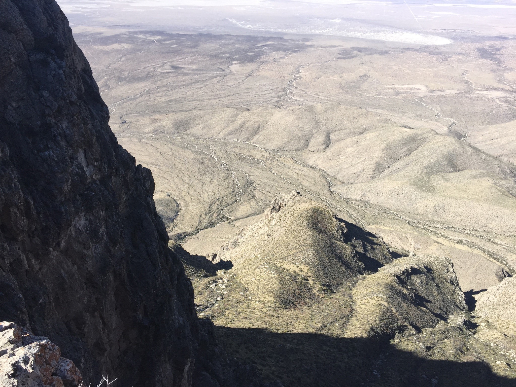
The fourth day was mostly off-trail, and connected the four tallest points in Texas. This route has been described a few times on Summit Post and an article in Texas Parks & Wildlife magazine (see links below). It’s a beautiful route that follows the western edge of the Guadalupe Mountains with a 4,000 foot drop to the desert floor. It skirts above massive cliffs to the west, above steep drops into canyons to the east, and follows a clear line from one peak to the next. This is what we’d come for. But it also has a challenging elevation change of 900 ft per mile, so you’re constantly fighting gravity.

The climb down Bush and up Bartlett was the easiest segment of the day. Instead of contouring down and around the south side of Bartlett we took a direct shot down the steep south side. This probably cost us more time than it saved. We climbed the ridge to peak 8374 which was kind of cutting against the grain but was more fun with better views than if we’d stayed low as originally planned.
The log books on the top of Shumard and Bartlett peaks had maybe 10 entries per year. While this route has been written up, it’s still only rarely hiked because you have to do it all in a single day in the cool winter months.
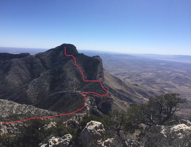
The hardest leg was from Shumard to Guadalupe peak. The red line is approximately the route we took. We got sucked into a thick mess of creosote bushes mixed in boulders that was a slow painful fight from about 7,800 ft to 8,200 ft. The climb up Guadalupe was steeper but easier after, this with a few sections of scrambling. From the top it was an easy 4 mile trail down to our car.
Gear we liked
Seek Outside Unaweep. They carried 40 lb of water plus food and gear well.
Bivy. We’d cowboy camp with bivys again unless there’s a real chance of rain. Tents or tarps probably would have been a disaster in that much wind. We saw no good sites for a tent, and only a few that were barely good enough for a bivy over the first 15 miles in Carlsbad Caverns NP. The ground is rocky and covered with cactus. Once you get to Lincoln NP there’s plenty of good traditional campsites, especially in the pine forest. And in Guadalupe Mountains NP you’re only allowed to camp at established sites, backcountry camping isn’t permitted. We planned our second night to camp at an easy water cache in Lincoln NP right before you reach GMNP. This meant we only needed one night in GNMP.
Hooded shirt or cap with flaps to keep sun and wind off the face and neck, and buff to keep wind out of face and ears.
Wind shirt – I don’t hike with wind shirts except in the desert. The Houdini was awesome on this trip to cut the wind and stop snags on brush.
La Sportiva TX2/3 approach shoes – great grip on rocks, but comfortable for hiking in. Pretty good protection against thorns.
Sunscreen and lip balm – even in February you couldn’t use enough
Tweezers and other tools – you’re going to get some thorns and spikes.
Water – We carried more than we needed, but would have needed if it were warmer.
Logistics
Be sure to check out Carlsbad Caverns while you’re out there
We took two cars to for shuttling between trail heads.
We cached water at Camp Wilderness which is accessed from the western side of the range, a long drive around the range.
You’ll need permits at both GMNP and CCNP. Both operate on Mountain Time.
Other resources
Backpacker Magazine https://www.backpacker.com/stories/grand-traverses-guadalupe-ridge-trail
Carlsbad NM Chamber of Commerce supported site http://guadaluperidgetrail.com/
Summit Post has some descriptions of how to get to Shumard and Bartlett peaks
Other GMNP trip reports on BPL:
https://backpackinglight.com/west-texas-wanderings-schmidt/
https://backpackinglight.com/forums/topic/29573/