<div>I am planning a trip in the Wind River range for this weekend and had a few last-minute questions. I already put up another post about preparing for the weather and general gear needed, so this post is more about the specific route itself. I am hoping to do some variation of the following route:</div>
<div></div>
<div>Day 1: Elkhart trailhead to Cook Lakes. Camp somewhere around Cook Lakes. Around 12 miles and 2k ft elevation gain. All on-trail according to the map, but I’m not sure how easy the trail is to follow there.</div>
<div></div>
<div>Day 2: Cook Lakes to Wall Lake to Indian Basin via “Wall-Island Pass”. All “off-trail”, although I’m not sure how much of a user trail to expect. Around 8 miles or so, with less than 1.5 kft gain. Camp somewhere in Indian Basin.</div>
<div></div>
<div>Day 3. Explore Indian basin, mostly without the heavy packs. Maybe move the tents to somewhere between Island Lake and the Titcomb Lakes.</div>
<div></div>
<div>Day 4. Day-hike up Titcomb basin to Bonney Pass and hopefully to Dinwoody Peak. Return to the same campsite (somewhere in the Island Lake/Indian Basin/Titcomb Lakes vicinity). 10-15 miles depending on the campsite location, with around 3k ft elevation gain. Not sure how hard the rocky terrain around Bonney Pass is.</div>
<div></div>
<div>Day 5. Return to the Elkhart Park trailhead. ~12 miles downhill.</div>
<div></div>
<div>OK, so here’s my questions:</div>
<div></div>
<div>1. This route is a variation of one of the routes in the Nancy Pallister guidebook. She says the “crux” of the route is on the East side of Wall Lake. If anyone has done that section, how hard is it? I would like to do this route counter-clockwise (as described in the itinerary above) instead of clockwise as described in the guidebook; is one of the directions easier for this crux? I don’t really want to do any class 3 scrambling with the heavy packs.</div>
<div></div>
<div>2. Are there any surprisingly tough areas on this route, either due to gnarly terrain, dense vegetation, or tough stretches to navigate? Should I expect any difficult stream crossings?</div>
<div></div>
<div>3. The guidebook suggests several optional add-ons such as Bald Mountain Basin (Spider Lake) and the upper Pole Creek area. I think I’m going to skip these so that I have time to explore upper Titcomb Basin and hopefully Dinwoody Peak, but if there are must-see areas to explore, please let me know.</div>
<div></div>
<div>4. Speaking of Dinwoody Peak, if anyone has climbed that, or even been up Bonney Pass, how rough/loose is the terrain? I don’t mind a steep class 2 climb, but I don’t really want miles and miles of big talus or loose rock.</div>
<div></div>
<div>5. My understanding is that there are plentiful camping options around Cook Lakes, Indian Basin, and Island Lake. Is that correct? Is it hard to find a good campsite at any of these three areas? Is Island Lake often too crowded to find a good free site? (I’m assuming there won’t be crowds in Indian Basin or Cook Lakes?) Is it easy to find campsites in these areas (particularly Indian Basin) that have natural protection from the elements? Are there good camping options around the Pole Creek Lakes if we don’t make it all the way to Cook Lakes on Day 1? If anyone has any favorite campsites in these areas that you’d like to share, I’d appreciate it!</div>
<div></div>
<div>Thanks in advance for any help!</div>
Topic
Cook Lakes to Wall Lake to Indian Basin to Titcomb Basin
Become a member to post in the forums.
- This topic has 4 replies, 3 voices, and was last updated 8 years, 11 months ago by
 .
.
That will be a great trip, with a great route. I did a similar one last year about this time.
Trip report here: https://backpackinglight.com/forums/topic/wind-river-range-sept-2016/
Caltopo route here: http://caltopo.com/m/F1T1
I elected to take Lester Pass instead of the Wall Lake cutoff. I’d recommend going to Cook Lakes first (as opposed to Island Lake), as you have planned. Last year we were at Cook Lakes on the Sunday of Labor Day weekend and we didn’t see other hikers. We hiked to Island Lake on Monday (Labor Day), by which time a number of people were hiking back out to Elkhart. Very few other hikers at Island Lake by Monday, but I understand that there were a few others on Saturday and Sunday.
There are excellent campsites at Cook Lakes and above Island Lake (see the photos linked in my trip report). Feel free to PM me if you have further questions.
Awesome! Thanks for the input Leap Frog. That’s why I wanted to do this loop CCW hitting Titcomb basin and Island Lake last, so that hopefully by Tuesday and Wednesday most of the crowds will be gone. Glad to hear that was the case last year.
Do you recall if there were many good campsite opportunities around Titcomb Lakes or between Island Lake and Titcomb Lakes? It seems like most trip reports mention camping at Island Lake as opposed to Titcomb Lakes, and I’m assuming that’s because there are just more good spots there. I’d love to camp North of Island Lake if possible though to shorten the Dinwoody Peak day hike (Day 4). I’m more concerned about finding a flat spot with natural wind protection than I am about finding a scenic spot.
Also, how hard was Fremont Peak? I read that it was “class 3″… would you say it was an easy class 3 or a hard class 3? Would that be a safe peak to consider for a class 3 novice? (I’ve only done 1-2 class 3 peaks before)
There’s an excellent campsite above Island Lake not far before the junction to Indian Basin – it’s on a broad rocky ridge running between the trail and Island Lake with some short, stubby trees and Krumholtz and boulders but otherwise fairly open and exposed (the ridge including point 10680+’). We saw people camping at the lake just below it (Lake 10467′) as well. This whole area North of Island Lake before you get to Titcomb Lake has many many campsite options if you explore a little. While it’s open with few trees you can find a reasonable protected camp if you want to.
There’s plenty of good, secluded camping near Island Lake as well, if you camp a few minutes into the trees due West from the lake’s central island instead of camping within sight of the lake like everyone else does. The forest is nice and open and just a few minutes walk from the lake. It’s only a 10 minute walk through open forest to the West to the trail heading to Fremont Crossing – a very short and pretty walk that’s worth doing if you camp in the area.
Regarding Bonnie Pass (the old Dinwoody Pass), it was a heavy snow year, so if there’s snow, it will likely be hard packed in the morning and requiring traction and an axe, unless you can bypass it. Dinwoody Peak is an easy, simply scramble on talus to the summit (did this back in 1991).
Re: Fremont Peak – this is a classic and very enjoyable to climb and likely has less snow on it than Bonnie Pass, but it is Class III in spots – a little steeper than Dinwoody Pk but still just a scramble. Also a shorter day hike from Island Lake than Dinwoody Peak, and you get to hike through Indian Basin too. In fact, one of my favorite places in the Winds is on the standard route up Fremont Peak. It’s on the ridge crest above Indian Basin on a gentle grassy area just below the Class III upper half of Fremont Peak – great views overlooking all of Island lake and Titcomb Basin. There’s also a Class III route down to Titcomb Lake from this perch, but it’s really hard to find going down.
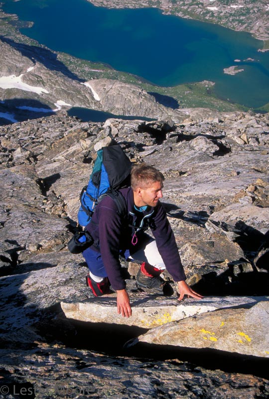
The upper Class III talus slopes on the standard route up Fremont Peak, with Titcomb Lake below.
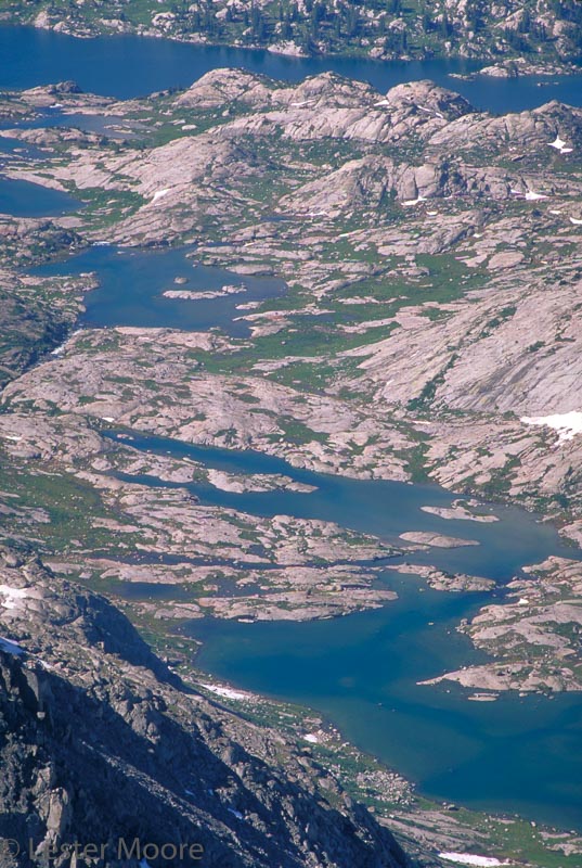
Island Lake in the background and the lakes leading up to Titcomb Basin from Fremont Peak.
Re: Lester Pass versus Wall Lake Pass – it’s a great option if you want to save a little time and stay on trail – great trail and views. Pretty lakes on both side of Lester Pass too.
Re: Wall Lake – it’s not too difficult, you just have to climb up and across a high granite dome that blocks the East side of the lake, maybe 200+ feet up above the lake. If I recall correctly there are ramps and broad ledges that go up and over this dome with nothing harder than Class II if you look around for a while and if in double go a little higher over the dome. We tried to stay closer to the lake at first and it was difficult until we went much higher. Haven’t been there since 1994, but I think it’s the dome at 10760+ on the map, due East of the smallest and most southerly of the two larger islands in the middle of Wall Lake. Look at Google Earth and you’ll see the ramps and ledges up and over the top of this dome.
In terms of Island Lake campsites, I camped just north of the lake near the waterfall inlet. Beautiful area that also provided ample windbreaks. It made accessing Titcomb and Indian Basins easy.
I’m not well-versed on scambling classifications, but you can get the effect from some of the pictures. We took just small daypacks. I used handholds in a few places but never felt unsafe or overly exposed, and I am a novice as well. Like Lester wrote, the views are outstanding. Just make sure that you get all the way into Indian Basin before heading up to the peak.
Become a member to post in the forums.
 Titanium Pot GrabberUltralight titanium pot grabber weighing just 4.5 grams.