Definitely some good beta, Mike. Were you still using the Shifts?
I’ve moved my route west, with the hope that the water is more manageable than the Sun / MF Flathead.
Topic
Become a member to post in the forums.
Definitely some good beta, Mike. Were you still using the Shifts?
I’ve moved my route west, with the hope that the water is more manageable than the Sun / MF Flathead.
“Shaping up to be a dandy :)”
Started packing last night which got me psyched. It is going to be rough out there. And yep, all the rafting options scare me at least a little, most quite a but more than a little.
5-6ish at Trixie’s?
yup Shifts- I ended getting a new pair, the decking is starting to split near the first straps- I’ll send them into MSR for warranty or repair, just didn’t have time
Dave- yup Trixies, we should be there about 5:30-ish
After going back and forth, I have decided to sit this year out. Good luck to everyone participating and I hope to see you next year!
Dan M, thanks for the spot in your car, but I guess I won’t need a ride now!
I got mostly packed tonight. Agreed on it being a tough year – perhaps too snowy to make good time in the woods, but too pushy to do a lot of rafting. Either will be a challenge. I’m planning to bring the Shifts and the raft. Might leave the raft if levels are spiking.
I also like how comparable the east and west side routes are. Hard to say what is the most efficient. Tons of great routes.
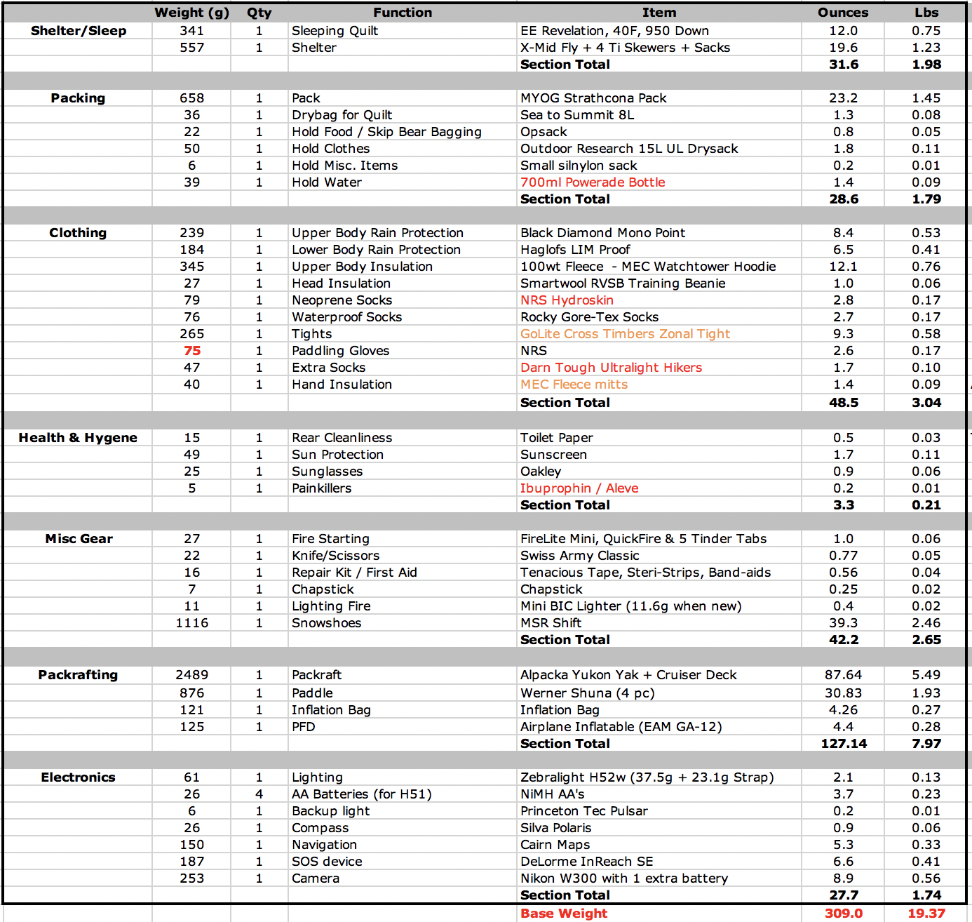
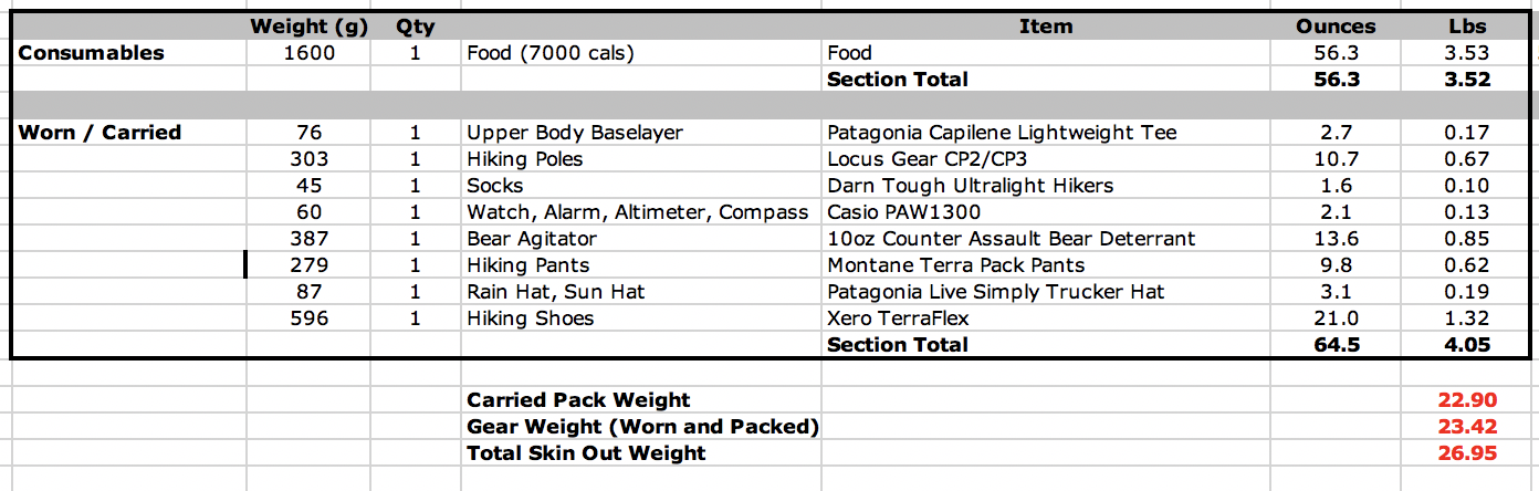
Gearlist will be something like below. Gonna try sleeping on a partially inflated packraft instead of a pad, to offset the weight of that boat a little:
Will
“How was that swim Dan? Somewhat ominously, Dave’s guide only describes sf flathead up to 10000 cfs”
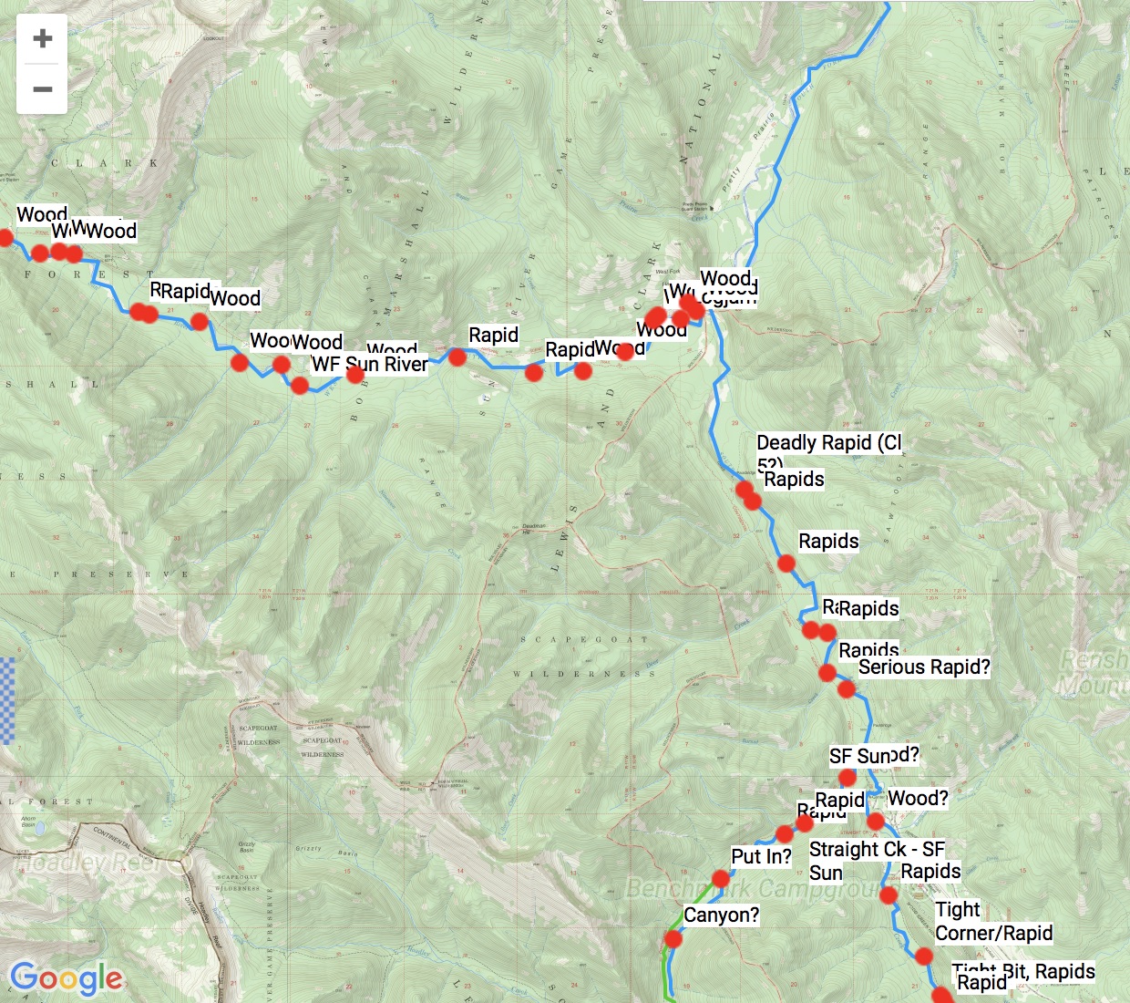
I dug up some old gauge data and it looks like the SF was about 8500 when I paddled it in 2013, and around 6000 in 2015. In 2013 I got flushed pretty quickly from that constriction at Black Bear Creek, but it is a scary spot. I paddled it again in 2015 and it was still scary. I’d like to be under 5000 before I’d paddle it. So I suggest taking out right at Black Bear Creek. You can take out on the right shore here, and the trail is right there. It’s only a mile or so before the regular take out.
Other than that, the “Burnt Park” area has a bunch of fast corners that look scary but aren’t too bad. There are a few spots with wood between Big Prairie and the White River, so you want to be on your toes. After the White River there are some scary obsticles in the river, but generally speaking you can give the standing waves etc. a wide berth, so you shouldn’t hit much trouble what you’re through Burnt Park.
Adrian
Have you found resources other than google earth for gathering beta on the potential challenging sections?
Just some trip reports, but they’re usually not that helpful because the beta is sporadic and the flows will be very different. Generally speaking, Google Earth is quite useful, other than the problem that conditions change from year to year, but old trip reports don’t help with that either.
Mike
“…the South Fork of the Sun above Benchmark looks very treacherous”
Just to clarify, does “above Benchmark” mean “upstream of Benchmark”? or “after/north of Benchmark”?
Dan- upstream of Benchmark; again I’m not a rafter, just a casual observer so take my notes with a grain of salt
looks like you have things parred down nicely, sub 20# with a raft and snowshoes is impressive! I’m a little over 20#’s without a raft :)
Mike
Thanks Mike. Yeah there looks like plenty to worry about in the Sun River near and above Benchmark.
I also noticed this nice hydrological outlook warning from the NWS morning.
Deadly rapids- that kind of says it all :)
Also if anyone was looking at Straight Ck- the ford to get across the SF of the Sun didn’t look very inviting to me
Thanks for the info on the water below Bear Creek. I was looking at paddling that last bit from info I had, and google earth, but it sounds like it won’t go as it looks.
Our packing lists look pretty much the same. I’m just at 20 lbs with the raft and shifts. How many calories are you bringing? :)
Dan always brings far fewer calories than would seem possible, but I think that helps drive him to the finish sooner
I always hope to put a few pounds on when I’m crossing the Bob! :)
Adrian
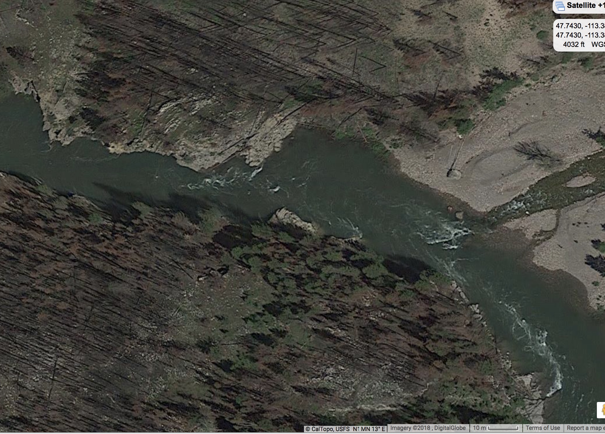
You can have a look at that little canyon at Bear Creek when you arrive to see if you want to run it or not, as there is a nice pool and take out right above this on river right. It’s easy to eddy out and mull it over. A big part of me flipping in 2013 was being fatigued and slow to react after a long day. I’m not a great paddler, so I’m sure for a good paddler it wouldn’t be much of a challenge. But it could also be much more serious at 15,000 CFS rather than the 8000 CFS I flipped at (and ~6000 CFS I was successful at in 2015).
Below Mid Creek gorge the River is generally fine, but there are some boils that are a bit creepy. It should be fine, but stay on your toes.
Calories
I did 6000 calories last years over 3 days and actually had 200 – 300 left over, but mostly because I lose my appetite when I’m pushing hard. I need calories to climb hills, but for flat walking I can metabolize enough fat to cruising.
But this year might take longer than last year and there could be some serious calorie burning post holing. So I’m thinking something in the 7000 – 9000 calorie range. I try to keep things personally challenging in the BMWO, so if the conditions were looking tame I might try to push it further, but I think I’m going to have my hands full as is.
Is this the spot (Bear Creek) where the water pushes you into the rock wall on river right, and then sometimes holds you, as it makes a sharp turn to the left?
This is the spot below. Bear Creek feeds in on the right, then there is a large pool where you can stop and look at the pinch point ahead (keep in mind at high flows this pool grows larger, while the constriction doesn’t).
In 2015 at about 6000 CFS it wasn’t hard to stop here. I stopped briefly to take a look at the constriction ahead. I didn’t take out, but it looked easy to do so via the gravel shoreline. This is where I would take out but there is another gravel area just upstream of Bear Creek also on river right. One could take out there and have this as a backup.
Before I forget, here’s the link to follow the GPS tracker. I’m not sure how many people will be keeping score at home, since Dan will be out on the field himself.
here’s mine (John got an inReach for his birthday a week ago, so he has one too :))
no password
“A big part of me flipping in 2013 was being fatigued and slow to react after a long day. I’m not a great paddler, so I’m sure for a good paddler it wouldn’t be much of a challenge.”
Dan D. doesn’t give himself enough credit; he has a lot of experience and has run stuff I wouldn’t even consider (like the S. Fk at 8000 cfs for example!). For some perspective from a moderate-level paddler who makes conservative choices, I went through that section last year at 3000 cfs and opted to avoid the rapids after Bear Cr. Probably just class II then and I would have given them a try if I hadn’t been solo at the time; can’t imagine how crazy they might be at this level (unless it’s just washed out entirely). Last summer, there was plenty of room to go around at river right (floating, not portage), but who knows what it’s like now. Personally, I would just take out at Black Bear cr. and not worry about it. That’s adding just 4.5 miles of easy, snow-free, level trail versus a big risk as the canyon narrows. On the other hand, don’t pack the wet gear away, because you’ll likely have to put in again to get around/ over Mid creek.
Also, don’t forget the tree sweeper up by Burnt Park where folks spilled in the past. I believe that was a mile or two past Burnt Park, but not sure. It’s just after the river splits and comes back together — tree sticks out from a big pile on river right and you want to paddle hard to river left to avoid the surprisingly strong current pulling toward the pile.
https://share.garmin.com/JohnNasset
no password
Here’s my InReach:
https://share.garmin.com/DanDurston
Thanks for the SF Flathead beta y’all. I’ve been looking at that constriction on google earth for like a month just thinking “huh” to myself. Sounds like a takeout at Black bear creek is very likely. I hear you about being slow to react, Dan. A lot of times I feel like my ability to maintain focus while coldish in a boat for many hours limits what I can safely run much more then my technical ability does.
Also: I just got back from two days in the Belly river area- I hiked up to sue lake, contemplated trying to get over to the highline via Chaney glacier but thought better of it, then floated the mokowanis and belly river back to the th. It was exquisite, worth the trip out here from Massachusetts just for that. Not knowing the area as well as a lot of yall, I don’t know the relevance of the conditions. Based on the gauges the rivers coming out of most of glacier definitely look a bit lower than the ones in the bob. But for what it’s worth:
– Snow in the NE facing drainages started around 5200 feet and became more or less continuous around 6000.
– The snowpack was well consolidated all the way up to Sue Lake at 7200 feet (aside from the obvious places: tree wells, downfall, etc). I used an ice axe and MSR lightning ascents for two steep snowfields with terrible runouts, but I would have been much happier with a lightweight crampon than the snowshoes. Postholing sucks but when bushwacking in the conditions I saw I would rather posthole periodically than navigate two feet of snowshoe around deadfall, etc. Plus trail crampons are lighter and give better traction on the steep stuff. I really only like snowshoes if the snowpack is pure powder or pure garbage. I’m rethinking taking them now since so much of my route is low, but maybe that’s foolish.
– After two warm and mostly sunny days the Belly was high but far from flooded. The bridge hadn’t gone up yet so I forded up to my chest but never felt like I might swim. The mokowanis below the falls before the confluence with the the belly was lots of fun but didn’t feel harder than it should (thanks to Dave for the tip in the packraft guide not to miss this section).
fyi – to matt, will , others looking for lift to start- i’m planning on being at marias pass at 12:30 fri ,meeting dan d . there – will have room if you looking for a lift–
Here is My InReach. I’ll be bringing up the rear. 5-6 day plan
<span id=”mapShareURLText” data-bind=”text: mapShareInfo.URL”>https://share.garmin.com/scottgrimm</span>
<p style=”padding-left: 30px; text-align: left;”>I’ll be bringing up the rear. 5-6 day plan</p>
I wouldn’t be so sure about that :)
Psyched that you got up to Sue and rafted that stretch Will, that place is awesome this time of year. Any bears?
Trying to wrap my head around the South and Middle Forks looking to head north (possibly well north) of 20k cfs by the weekend, though the South Fork of the Sun currently at 3500 is oddly enough harder to picture. Historic data for the gauge just above the Klick Ranch is spotty, but I don’t think I’ve had more than 800-1000 for that stretch personally. Snowshoes, raft gear, foam PFD, and a drysuit seems both excessive and underkill at the same time.
Everyone should expect pretty much worst case scenario for almost all the stream crossings.
With most of my stress being centered around floating, I’ve had to continue to remind myself to be mindful of the walking water crossings. At the very least I can float across the Spotted Bear if a ford is impossible, or walk back to the campground and cross on the road.
Yeah, I actually got a half-hearted charge from a young looking grizz on the border swath about a quarter mile from the TH when I came up over a bench and surprised it. It was half-hearted on the bear’s part- my heart was beating at about 250 bpm of course, but it pulled up around 80 feet short of me and ambled off in to the forest after watching me back away for a while. I need to remember not to smell the barn and quit yelling just because I’m near a TH.
Adrian, are you planning on rafting the SF Flathead? My main concern at this point is the water level washing out eddies and making strainers much more dangerous. Good reminder not to forget about the other crossings though!
Become a member to post in the forums.
 Air-Permeable Fleece HoodieLightweight fleece hoodie weighing just 5.2 ounces.
 Loading...