Topic

Bob Marshall snowpack/melt this year


Forum Posting

A Membership is required to post in the forums. Login or become a member to post in the member forums!

Home Forums Off Piste Packrafting Bob Marshall snowpack/melt this year

Viewing 25 posts - 1 through 25 (of 27 total)
  • Author
    Posts
  • #3395805
    Skibbs
    Spectator

    @skibbs

    Locale: Conifer, CO

    Snowpack looked light this year based on the NRCS site:  http://www.wcc.nrcs.usda.gov/webmap/index.html

    How has el nino affected the area this winter?  Expecting an early melt?  Another really dry summer?

    I have a packrafting trip planned for late July just trying to get some feedback… may be a smidge early in asking this but i’m already anxious for my trip :)


    #3395931
    Dan Gregerson
    BPL Member

    @dlgregerson

    Locale: Bob Marshall Wilderness

    Others will likely provide a more thorough response, but from my perspective, it’s been a relatively normal year overall for snowpack. Most of the state is reporting near normal to above normal snowpack (big exception being areas just east and southeast of the continental divide/Chinese Wall, which are closer to 70% of normal). Seems to me the melt has been a bit early, perhaps 2-3 weeks sooner than average. The official projection is for a “normal” fire season.

    I’m planning a packraft trip for the first week in July, trying to hit the ‘sweet spot’ of around 3-5000 cfs on the South Fork (based on the work of Dave C.). I would guess a person would still be fine the second and third week in July, but things might be a little thin by the end of the month. Obviously, this could all change rapidly if the sunny weather really kicks in.

    #3396050
    Skibbs
    Spectator

    @skibbs

    Locale: Conifer, CO

    Thanks for the info, I erred on the side of caution (as far as CFS flows) as we have a decent sized group going this year and are all novices.  We are planning to do a lot of fishing so dragging in the upper reaches isn’t too big a deal since we will be in and out a lot anyway.  From my notes taken from various sources the upper reaches requires a minimum of 900cfs to avoid dragging and 1200 is recommended from the confluence to big prairie.

    I looked up the CFS averages on the USGS site between 2008-2015 on the day we will hit the headwaters and removed 2 outliers (2011 @ 3500cfs and 2015 @ 575cfs) which brings the average to 1170cfs, hopefully it works out ok for us.

    EDIT: http://flatheadbeacon.com/2016/04/08/snowpack-levels-remain-average-in-northwest-Montana/  found this article… sounds like better snowpack this year but who knows what the next few months will bring to your area….  “At this time last year, snowpack appeared to be in good shape before spring, but below average precipitation during March-June resulted in below average flows in our rivers last summer and fall. Given current conditions and assuming normal precipitation and temperatures over the next three months, this year looks to be different.”

    #3396365
    Dan Gregerson
    BPL Member

    @dlgregerson

    Locale: Bob Marshall Wilderness

    According to the fire information site: Inciweb the Bob received “10 inches of new snow” at lower elevations this last Wed-Thursday. Nice little boost for the snowpack!

    This far out, we can only make educated guesses which lead to ‘most likely’ scenarios, but ultimately, if geared up properly (which includes attitude), there’s no ‘bad day’ to be in the Bob.

    Look forward to hearing how the trip turns out!

    #3396452
    David Chenault
    BPL Member

    @davec

    Locale: Queen City, MT

    Low elevation stuff melted early, but the higher elevations are what is important for runoff, and thus far the spring has been cold and snowy. Best guess at this point is that the floating in the Bob will be a little lower than normal, but not much. Mid July would be safer than late July. As Dan mentioned the Sun River forks will go down quite early unless something drastic happens.

    #3401445
    Skibbs
    Spectator

    @skibbs

    Locale: Conifer, CO
    #3403400
    Skibbs
    Spectator

    @skibbs

    Locale: Conifer, CO

    Badger Pass around 7000′ in the Bob looks awfully thin on average for this time of year, even lower than last year at this time… is this a decent gauge of the higher elevation snowpack?  Would a wet June mitigate this low snowpack enough to not be in the situation as last year?  How dry was May/June last year?  Thanks.

    NRCS Link


    #3404196
    David Chenault
    BPL Member

    @davec

    Locale: Queen City, MT

    Usually Badger is a good metric, but for whatever reason this year the east side of the Bob was light on snow.  Look at the Flattop snotel in Glacier for a more representative picture.  Still a decent amount of snow up high, and it will take some good heat for it to let loose.

    Last May and June were very dry, and June was exceptionally hot.  No question that the rivers will drop sooner than usual, but a cool and rainy June could help a great deal.  If June is hot and sunny the rivers will spike once more, then drop off for good, much like last year.  If June is cooler, that final peak of runoff could be pushed back towards July, and we could have a closer to normal curve.

    #3404428
    Skibbs
    Spectator

    @skibbs

    Locale: Conifer, CO

    Thanks for your help David, appreciated

    #3406583
    Owen M
    BPL Member

    @harryhood04

    I have a trip planned for June 16-23, and I am worried that I might hit it perfectly for the South Fork to be too high but the upper Middle Fork and the Sun forks to be too low.  Any thoughts from anyone?  I guess there’s nothing I can do at this point. Just have to see how the weather unfolds and then make the best game-time decision at the start of the trip.

    #3406751
    David Chenault
    BPL Member

    @davec

    Locale: Queen City, MT

    The forks of the Sun will be problematic this year, as the snowpack was particularly low over there, and those drainages (esp the N Fork) have lower altitude basins.

    I actually think the third week of June will be a decent bet for that trip.  Low water on the Sun will be more of a concern than high water on the S Fork Flathead.

    #3409866
    Skibbs
    Spectator

    @skibbs

    Locale: Conifer, CO

    Wish I could move my trip up a couple weeks but the logistics make it impossible for me to change my itinerary at this point..

    Gauge is only about 450cfs higher than last year at this time so i’m expecting a lot of dragging in the upper reaches when I go but plan to do a lot of fishing anyway and hopefully will be better going once I make it to Big Prairie.

    Let us know how your trip went when you get back Owen :)

    #3410735
    Owen M
    BPL Member

    @harryhood04

    My trip was amazing.  I just got off the trail a couple days ago, so I’m still resting and recovering (and eating a lot).  I am grateful that the river was at a good level for packrafting–not too high that the fish weren’t biting and not too low that I had to do any dragging on the South Fork.  Just below 3000cfs, which was a great level.  The fishing was unbelievable.

    I hope that there’s still enough water for a good trip for you OP.  Late July might be a bit sketchy, so you could consider going in over White River Pass and starting the South Fork from there.  I wouldn’t want to be dragging half the day in those upper reaches.

    All in all, I had a very powerful experience.  A week alone in the Bob is an intense and beautiful time.  I pushed myself to some edges physically and mentally, but I came out happy, healthy, and rejuvenated by the fantastic land there.  Thank you Montana for hosting me for a week.  And thank you, Dave C, for your enthusiasm and generosity in posting about packrafting in the Bob.  I can’t wait to be come back next year and explore more rivers and creeks.

    #3411017
    David Chenault
    BPL Member

    @davec

    Locale: Queen City, MT

    Glad you had a good trip Owen. In many ways I’m jealous; that first trip experience is a big deal and can never be recaptured.

    It has been and will continue to be a weird year for our rivers. Plenty of high altitude snow left in Glacier, a bit less in the Bob. I expect another surge whenever we get a few days in the 90s again, but things will bottom out early. August will likely be marginal for flows.

    #3412871
    Skibbs
    Spectator

    @skibbs

    Locale: Conifer, CO

    Glad to hear you had a good trip Owen!  This will be my first multiday packraft trip as well (South Fork).  Looks like there has been some mild weather this week and again through next week, including some rain.. definitely cooler and wetter than last year so while conditions may not be ideal hopefully it wont be too rough.  Dragging will be… well a drag, but I can think of worse ways to spend a day here in TX :)

    #3413004
    Dan @ Durston Gear
    BPL Member

    @dandydan

    Locale: Canadian Rockies

    FWIW, paddled the SF Flathead and NF Sun last week (last week of June 2016). SF was fine at ~2500 CFS but the NF Sun was really low at ~240 CFS. It was definitely last call for that river for the season unless there is a lot of rain. We did a lot of scraping.

    Also FWIW, the NF Sun carved out a new channel for ~200 yards about halfway between Gates Park and the reservoir. There is about 50 trees across this new narrow channel. Hopefully next spring changes that.

    #3413295
    Dan Gregerson
    BPL Member

    @dlgregerson

    Locale: Bob Marshall Wilderness

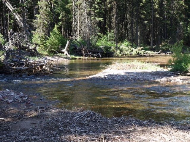
    I did the “Bob-White Loop” last week; floated the South Fork on 7/3/16 when it was ~2000 cfs. Put in on Danaher about half a mile downstream from Camp Cr and it looked like this:

    This is the worst spot on Danaher:

    Between the scraping in shallow sections and wood pressure, I spent more time out of the boat than in. It took 2.5 hours to go 4 miles to the confluence, which is slower than even I hike. After the confluence, it was much better; although, still lots of rubbing, especially anytime the river braids.

    As an ‘advanced beginner’ or ‘low-level intermediate’ rafter, I spent many hours worrying about the Burnt Park section; however, I’m happy to report than when I finally got to the focus of my anxieties, it was no problem, actually quite fun standing waves with minimal rock dodging. Grateful again to Dave C. for intel on the ‘dead tree rapid’ (not actually a rapid, but a sweeper sticking out of a large pile of trees river right), which allowed me to recognize it immediately and take a strong left line. There really is a powerful current pulling you toward that pile, so even at this level, you don’t want to underestimate it. A couple who went through just behind me (two people, two dogs, one boat) took a swim there.

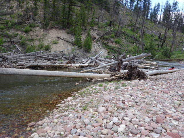
    This is the take out at Holbrook ford just upstream from the White river confluence:

    I hiked over White River Pass and back to Benchmark over two days. I judged the West Fork of the Sun to be too low already, so hiked the last section out. It looked like a very fun river at the right level (although I have to give props to Dan D. for floating the N. Fk. at such a low level! Makes me a wimp for passing on the W. Fk.)

    If you have flexibility regarding the route of your trip, I would suggest moving the put in as far south as reasonable for more water — perhaps Gordon Cr., Big Prairie, or even to the confluence with the White R. Folks with more experience may disagree, but as a novice packrafter, I worried about the wear/tear on the bottom of the raft with all that scraping. Thank God it’s nearly indestructible!

    #3413654
    Skibbs
    Spectator

    @skibbs

    Locale: Conifer, CO

    Thanks for all the great trip reports and pictures!  Looks like the SF basin caught that rain so river has gone up a bit so i’m happy about that.  I have heard reference to Burnt Park in many posts as a place to watch out for but never see it marked on any maps.  Is this where Burnt Creek dumps into the SF?  Any other spots of concern?  I have backpacked in the Bob and can only think of another problem spot being just above where black bear creek dumps in.  Anything of major concern between black bear creek and mid-creek takeout?

    #3413691
    Owen M
    BPL Member

    @harryhood04

    The wave trains get a little higher the closer you get to mid-creek takeout, but I wouldn’t say there’s anything of real concern.  I would rate the whole SF above the gorge as consistently class 2–enough to keep you on your toes or cause you to flip if you don’t make the right moves (especially in a packraft), but never anything I would call a Class 3 “rapid.”  The consequences of a swim are minor, and even if you lose your boat the chances are it won’t get very far before eddying out somewhere.  Nothing requires any scouting.

    What could be dangerous is if you miss the mid-creek takeout and end up unexpectedly going into the gorge.  Someone posted on the 2016 Bob Open thread recently who did this.  Make sure you pay close attention as you’re getting close, as the water is moving pretty quickly down there.  Look for a large wooden sign high on the right bank that’s kinda hard to read.  It’s not in a great place, imo, as it’s located right after the place to take-out.  There’s also a long gravel bar on the right just before the takeout.  I played it safe and took out at the beginning of the gravel bar, cause I wasn’t sure where I was and the sign looked like something vaguely official (but impossible to read from afar).

    #3413692
    Owen M
    BPL Member

    @harryhood04

    I’ll edit my post to say that there is always a real risk while boating and that strainers/sweepers can be deadly even in minor rapids or at low water.  If you flip or fall out, it’s always a good idea to keep your feet downstream and try to hold on to any objects (logs, rocks) that you bump into rather than allowing yourself to get sucked under them.  And if you’re nervous or with very inexperienced boaters, a whitewater helmet, while probably not necessary for the SF, can be a helpful safety/piece of mind item to pack.

    #3413722
    Dan Gregerson
    BPL Member

    @dlgregerson

    Locale: Bob Marshall Wilderness

    Burnt Park is just upstream from where Burnt Cr enters. If you count the confluence of Youngs and Danaher creeks as river mile 0, the bumpy sections are apx. river miles 8 and 10.5. Burnt Park is identified on the Cairn maps, which are awesome resources and I no longer plan trips in the Bob without staring at them a long, long time.

    Which leads me to a silly, but effective trick for remembering where to watch for these two sections. If you look at a map of the S. Fk, after Big Prairie, the line of the river forms ‘three big bumps,’ i.e., actually large curves to the east. Mile 8 is at the bottom of the first bump. After the third bump, there is a very sharp corner to the right (east) and 10.5 is after that corner. Looking at the river via Google Earth, I had guessed that sharp corner was itself the problem, but it’s just a deep hole, the fun bits come after.

    Hope that helps, ’cause I’m a little embarrassed to admit I floated while chanting to myself “three big bumps.”

    #3413755
    Dan @ Durston Gear
    BPL Member

    @dandydan

    Locale: Canadian Rockies

    At 2500 CFS on the SF Flathead we put it at the Danaher/Youngs confluence. There were a few spots I thought were shallow, but after floating the NF Sun at 240 CFS now it seems like there was so much water there. I was surprised we made it down the NF Sun without portaging any large sections for being too shallow. There was lots of careful line picking and some occasional boat dragging.

    Burnt Park was no issue at all at 2500 CFS. It was trickier in the past at 6000 CFS but it also looks like the river has taken a new inside route at the hardest corner (sharp bend with a boulder in the middle) so now it ‘s not much more than a few faster corners with wave trains. There was some wood across the river upstream of Big Prairie. I recall it being clear after that.

    The log that was over the river at the mini gorge at Black Bear Creek is now gone sadly. That was my plan to cross the South Fork had I attended the Bob Open – quite likely I would have arrived there disappointed.

    I think this is probably “dead tree rapid” with a victim in the foreground. At 2500 CFS, a nimble paddler can avoid or duck under the log.

    With super low flows on the NF Sun, we also paddled the lower gorge which was easily scouted and could be easily portaged although the half of our crew that opted in managed to paddle everything, albeit with a few swims. I posted a little more beta here: http://packrafting.org/forums/viewtopic.php?f=37&t=1578&start=10


    #3413836
    Dan @ Durston Gear
    BPL Member

    @dandydan

    Locale: Canadian Rockies

    I just finished a short video of my Bob Loop this year. There’s some good footage of both rivers and our ascent of Silvertip. You can also see a near miss with the “dead tree rapid” at 1:10

    #3413908
    Dan Gregerson
    BPL Member

    @dlgregerson

    Locale: Bob Marshall Wilderness

    Great video Dan, thanks for sharing that. Looks like you gave a bunch of people the trip of their lives (and makes me want to climb Silvertip).

    #3413923
    Dan @ Durston Gear
    BPL Member

    @dandydan

    Locale: Canadian Rockies

    I got the Silvertip idea from Forrest McCarthy and Tom Turiano when I ran into them back in 2012. They made it look great in there video (easy to find on YouTube). The Silvertip route has some good brush on both sides but the middle 80% with all the alpine is 5 star. If you’re ever heading this way send me a message and I can provide some more specific advise.

Viewing 25 posts - 1 through 25 (of 27 total)
  • You must be logged in to reply to this topic.
Forum Posting

A Membership is required to post in the forums. Login or become a member to post in the member forums!

Get the Newsletter

Get our free Handbook and Receive our weekly newsletter to see what's new at Backpacking Light!

Gear Research & Discovery Tools


Loading...