Topic
Bob Marshall Open 2019
Forum Posting
A Membership is required to post in the forums. Login or become a member to post in the member forums!
Home › Forums › Campfire › Hiking Partners / Group Trips › Bob Marshall Open 2019
- This topic has 155 replies, 26 voices, and was last updated 5 years, 7 months ago by
 Jane Baack.
-
AuthorPosts
-
May 20, 2019 at 1:56 am #3593746
Well, I ended up picking up a Smith River permit for the 23rd. Not sure the Smith float for 5 days will have any better conditions than the Bob but looks like I’m out for this year. Between picking up the permit and my packraft not going to make it in time for the Bob i’m gonna bail on this years Open.
I’ve got the whole week off of work so I might head in on Wednsday or Thursday for a short trek. Good luck to everyone. I’ll be watching reports. Looking Ominous!!
May 20, 2019 at 2:08 pm #3593790Scott- enjoy the Smith, see you next year
Dan M- there were times additional flotation would have been handy on our outing last weekend, but for the most part the Shifts were fine
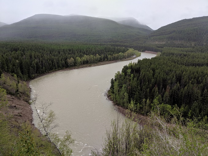
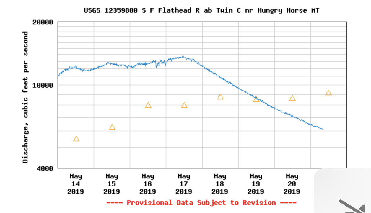
May 20, 2019 at 3:19 pm #3593796I spent the weekend scoping out the water conditions on Spotted Bear and the South Fork downriver from the foot bridge. Saturday, the gauge above Twin Creeks was reading 11,000 and the river was big, but nothing too frightening. Even that hairpin bend before the bridge never got rowdy.

The falls on Spotted Bear just below Big Bill Creek were ripping pretty good, and there’s not much of a chance to exit above them.

In light of that, I opted to float from the Trail Creek Trailhead access just below the corrals. It takes a little bit of attention, but there’s nothing overly scary most of the way. Wood is easy to spot, and I never saw anything bigger than a small branch floating down the water.

The canyon by the ranger station is easily floatable, but the confluence has some scary hydraulics with a couple gnarly whirlpools. I’d recommend taking the inside corner and catching the eddy up a ways to position yourself to get past the rocky point.

Basically, Spotted Bear & SF Flathead are good to go. It seems the scary stuff this year will be the snow. For anyone looking to track me, my mapshare is https://share.garmin.com/acupino and my InReach is andrew.cupino@inreach.garmin.com
May 20, 2019 at 4:12 pm #3593801My first thought looking at the forecast this morning was that it would be somewhat difficult for conditions to be worse this coming weekend. Looking at snotel and streamflow data doesn’t change that opinion much.
May 21, 2019 at 2:33 pm #3593943Thanks for those pictures of the Spotted Bear Andrew. Nice to see those falls near Big Bill Ck. I was wondering what that was on the satellite.
River levels in general have come down a lot from a high of near 15,000 on the SF Flathead a few days ago to 6000 now. That may change, but it’s looking like a relief after the super high water last year. The SF Flathead was stable near 20,000 during the BMWO last year.

My map link is:
May 21, 2019 at 3:51 pm #3593953Will, I’m leaving my car at the start as well. My wife is flying and then driving in to pick me up at Swan Lake on the 28th. We’re gonna rest at a hotel and then go pick up my car at Swift sometime between the 29th and mid-day on the 30th. I was planning on checking to see if anyone needs a ride back to the start, so you and anyone else are welcome to ride with us if that suits your schedule.
May 22, 2019 at 2:23 pm #3594082Has anyone ever gone off trail from Gunsight Lake to Whitcomb Creek (to the FS road)?
May 22, 2019 at 6:08 pm #3594117I haven’t. It looks like it would work though.
May 22, 2019 at 6:15 pm #3594118I haven’t either, but looking at the map- agree with Dan D
May 22, 2019 at 6:22 pm #3594119See post #3593670 ;)
May 22, 2019 at 6:26 pm #3594120Matt, Dan, & Mike,
I was just there Saturday.
May 22, 2019 at 6:27 pm #3594121Tom, thanks! Is that the photo from the post you mentioned?
May 22, 2019 at 6:33 pm #3594122Matt,
Your welcome. It was taken at 47.9800, -113.3498
May 23, 2019 at 12:46 pm #3594211Hey Matt,
Glad that you’re back this year. I was planning to take that same cutoff down Whitcomb just before Gunsight lake. Looks like there’s an old user trail that takes off a little ways before the lake, although I won’t be surprised if it fades out in the burn. Certainly looks doable and less switchbacks, as long as the bushes haven’t gone crazy since the last google earth image. Look forward to seeing you at the start!
May 23, 2019 at 2:23 pm #3594218Here we are, less than 48 hours out from my 5th consecutive Open. I’ve not trained as much as past years but what I’ve learned from previous years is for me it’s more of a mental game. I have a willingness to suffer for the Bob. We have been super fortunate with great weather the past 4 years but looks like that may be coming to an end this weekend. All of our chosen route is new trail for me so that has me pretty excited. Still up in the air about shelter-was hoping to just use my poncho tarp and bivy but may end up throwing in something more substantial. My inReach address is [email protected] and map address is https://share.garmin.com/JohnNasset. See y’all tomorrow.
May 23, 2019 at 7:11 pm #3594269Did we agree on Buffalo Joe’s in Dupuyer for dinner? I guess around 5 or 6? I’m meeting my ride at the finish at noon, so I should be in Dupuyer around 3 or 4.
Also, am I missing all the bad weather forecasts? In the valleys it looks like weekend highs around 50F and lows in the high 30’s, which is reasonable – and then mostly cloudy weather with precip chances on Sat and Sun around 60% and 40%, with maybe a 1/10th inch falling in scattered showers. Seems a lot better than the blizzard of 2012.
https://forecast.weather.gov/MapClick.php?lon=-113.2880307534209&lat=47.922649008987605#.XObz8C0ZPOQMay 23, 2019 at 7:18 pm #3594270that’s the plan- I should be arriving about 6
May 23, 2019 at 8:30 pm #3594292Super excited to meet everyone.remember the most dangerous part of hiking is driving to and from the trail-head. Safe travels everyone!! https://us0-share.inreach.garmin.com/twofeathers
May 24, 2019 at 1:28 am #3594333“…..the most dangerous part of hiking is driving to and from the trail-head.”
This seems likely to make it into my trip report: “As mama grizzly stalked closer, I took solace in knowing the most dangerous part of hiking was driving to the trailhead”.
May 26, 2019 at 2:31 am #3594661Tragically, it appears that the mama griz has eaten Dan’s inReach. Or more probable, a wolverine.
Nothing like an evening stroll up and over the Trilobite Range, in May. Jealously level is high right now. Well done Dan, and others as well (haven’t been able to see the other maps).
May 26, 2019 at 3:03 am #359466624 starters this morning; a new record.
Looks like Badger Pass didn’t go easily, but it didn’t slow folks as much as I would have thought. Dan has the previous 3 years of tracks still live on his page.
May 26, 2019 at 4:01 am #3594675Sun setting on day one. Never has it been more exciting watching dots connect across a computer screen. Looks like a challenging first day all around. Middle Fork looks like it may have given John and crew a tough ford … or a really long dinner break. With that crew, what would a Bob Open be without a really sketchy butt-scoot across a log that may or may not break and float away.
Thad probably fond another cottonwood.
What will Sunday bring?
May 26, 2019 at 10:27 am #3594693Tom hasn’t stopped moving all night. Waiting for his 4:06 am ping to show
May 26, 2019 at 4:56 pm #3594738Sad to say I bailed early this morning at Bear Creek trailhead. I’ll post a full report later but here’s the short story:
Had a fantastic first day except for some weird metabolic stuff (pooped 4 times and bonked harder than usual when I didn’t eat). Dan led us through gateway pass and then I paddled everything on the MF up to granite. Took out there at around 9:30 and hiked up to Spruce Park, getting there around 2:15am for a 60ish mile first day. I tried to sleep but realized that my experimental system (active layers and a drysuit on a small neoair) meant I was basically not gonna sleep at all this trip as I thought the drysuit would add a lot more warmth than it did. But that was fine since I was shooting for just one night out there, so I inflated for a dark crossing of the MF and headed down Long creek. Turning onto the Bergsicker creek trail around 4:30 I was not feeling good. First I thought I was just sleepy and cold. Then I thought I was bonking, but looking at my food I didn’t want to eat it. Then I was puking. I wanted to build a fire to buy myself some time to see if it was just a passing squall, but finding anything but truly soaked wood before first light was nearly impossible and I couldn’t get anything good going. So without a fire and without enough insulation to stay warm stationary I had to get moving, which meant choosing between going forward and bailing. Going forward seemed unwise having just put myself even deeper in a calorie hole. Plus I have to admit I wasn’t super inspired about gaining 3k feet, much of which was sure to be on bad snow, to gain circus peak when it was probably going to be covered in clouds and sans view. So I bailed.
May 27, 2019 at 12:29 am #3594836Around noon and still 5 miles from the Posey Creek turn, I called for a ride due to a painful knee. Tom, I am assuming you finished already or close to it. Nice job. I had fun trying to catch you last night in the dark :)
-
AuthorPosts
- You must be logged in to reply to this topic.
Forum Posting
A Membership is required to post in the forums. Login or become a member to post in the member forums!
Our Community Posts are Moderated
Backpacking Light community posts are moderated and here to foster helpful and positive discussions about lightweight backpacking. Please be mindful of our values and boundaries and review our Community Guidelines prior to posting.
Get the Newsletter
Gear Research & Discovery Tools
- Browse our curated Gear Shop
- See the latest Gear Deals and Sales
- Our Recommendations
- Search for Gear on Sale with the Gear Finder
- Used Gear Swap
- Member Gear Reviews and BPL Gear Review Articles
- Browse by Gear Type or Brand.


