Topic

Advice needed for Wind River Range in early Sept.


Forum Posting

A Membership is required to post in the forums. Login or become a member to post in the member forums!

Home Forums Campfire Trip Planning Advice needed for Wind River Range in early Sept.

Viewing 25 posts - 1 through 25 (of 25 total)
  • Author
    Posts
  • #3382373
    Leap Frog
    BPL Member

    @leapfrog1

    I’m planning a trip to the Winds around the first week of September. Would likely have around 5-6 days of hiking, possibly covering 10 – 12 miles per day.

    Any suggestions on route or helpful resources? I don’t think I’d have time for a full 80-90 mile hike (traverse, High Route, etc.).

    Thanks for your advice and suggestions!

    #3382393
    Lester Moore
    BPL Member

    @satori

    Locale: Olympic Peninsula, WA

    The Winds are really beautiful in the Fall. I’ve seen a few inches of snow on the ground at Island Lake in mid September and temps in the low 20’s, so plan accordingly.

    For a 6 day trip, I really liked the last one I did in the winds, going in at Elkhart Park past Seneca Lakes, Fremont Crossing to Jean Lakes, then past Elbow Lake to Summit Lake and back. Or, stop at Jean Lakes, backtrack a half mile S of Fremont Crossing, then cut easily cross country to Island Lake, then back out. Could also visit Island Lake, then hop over Wall Lake Pass (or backtrack to Seneca and hop over Lester Pass), then head past Cook Lakes to Pole Creek Lake and back out.

    Many people just set up a base camp in the Island Lake area and so day hikes from there (such as Titcomb Basin, Indian Basin, Fremont Peak, etc.) However, it’s more crowded and impacted at Island lake so I like to avoid camping there.

    Many many good options.

    #3382397
    Link .
    BPL Member

    @annapurna

    Andrew Skurka’s Wind River High Route
    It includesBASIC INFO

    Overview Map
    Route Description
    Elevation Extremes
    Route Development Parameters
    History
    Trail & Route Comparisons
    Section Hikes
    GEAR & SUPPLIES

    Clothing Systems for the Winds
    PLANNING INFO & RESOURCES

    Scheduling Considerations
    Topographic Maps
    Trailheads & Transportation
    Are you ready for the High Route?
    WRITINGS, PHOTOS & VIDEOS

    Alan Dixon and Don Wilson Wind River High Route – A Guide
    Alan and Don have a lot of great info
    BPL Member Ed Hyatt’s Write up from Aug. 2015

    #3382517
    George F
    BPL Member

    @gfraizer13

    Locale: Wasatch

    A great time of year and so many options. A lot of sources mention the chance of an early season storm before the fall weather settles in, so my only thought is to be hesitant about a planning route that crosses over to the back side of the range. That way if you do get hit, which isn’t that likely, you don’t have to cross any high passes to get back out. You have so many choices of great trips in the Winds this shouldn’t be an issue.

    #3382525
    Dean F.
    BPL Member

    @acrosome

    Locale: Back in the Front Range

    The weather could turn on you, but it probably won’t.  I know that’s not terribly reassuring but that’s the way it is.  Maybe as advised above just avoid high passes in your planning.  I was in the Winds a couple of years ago in August-September and all was fine other than being unusually wet.  We had planed to do the high route but the weather was just barely looking threatening for the hop over Knapsack Pass so we bailed to doing the CDT from Green River Lakes to Big Sandy.  Which, frankly, I still regret because the weather cleared within a couple of hours.  But, I find myself being much more conservative since I had a kid.  I’ll be back to do the high route at some point.

    Frankly, if you just get a map set and scope out almost any route on the regular trails that makes sense then you will not go wrong.  The Winds are truly one of the last great places.  Unlike most, I like the Green River Lakes end of the range more than around Titcomb, but I’m weird.

    #3382528
    Andrew Skurka
    BPL Member

    @askurka

    Leap Frog –

    Since it was offered by @annapurna, I want to quickly chime in. With 5-6 days and with the intention of covering 10-12 miles per day, I would not recommend either my route or Alan’s. Most folks will see a 25-50 percent reduction in their normal miles per day on either of these routes, depending on their off-trail skills and fitness. It wouldn’t seem like you have enough time (which you suspected), and I generally think you would be better off staying mostly on trails so that you can see more.

    The only related option that I might recommend is a Wind River High Route section-hike, which range from 37-67 miles and can be done in 3-7 days, depending on the route and, again, fitness. Some loops are harder than others; you might want to look into Loop 1 or 2. More details are here: http://andrewskurka.com/adventures/wind-river-high-route/section-hikes/.

    Andrew

    #3382586
    John Vance
    BPL Member

    @servingko

    Locale: Intermountain West

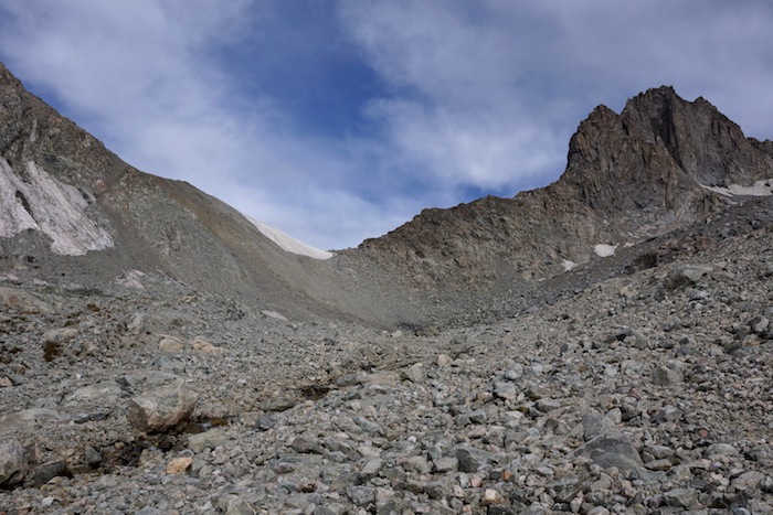
    I have been on all the high route options and the most difficult section would be Indian pass through the the Alpine lakes, which is certainly one of my favorite areas in the Winds, but there are many favorite places to choose from.  You are pretty much committed thought that section and it wouldn’t be easily done in foul weather.

    Also, don’t overlook the northern end going in at Green Lakes or Dubois along the new or old glacier trail.  If you are comfortable with off trail travel high above tree line the northern end of the range is truly spectacular.  From Green Lakes You could head up past Slide lake taking the drainage heading SSE up to Baker Lake and follow the divide north or dropping down along Kevin lake, Hourglass, Rocking horse, past Daphne and make a big loop due north past Roaring Fork and then back west over the divide and down the CDT back to Roaring Forks and Green Lakes.  If you like to see Big Horn sheep, this area will not disappoint but you will have hunters up there at that time if that is an issue for you.  This is also the area where I have seen Grizzlies on two occasions, both late September early October.

    You could also go south from Baker and out Tourist canyon as well, drop down to Elk park as I recall and up and over the pass to Lozier Lakes and head north over Porcupine pass and down back to Green lakes.

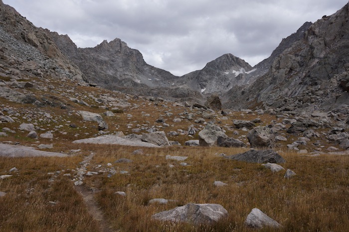
    The options are many and each one has the opportunity to provide a very memorable trip.  I am not as well traveled as Andrew, but in over 40 years of backing, I haven’t found a finer place to spend time than the Winds.  Throw in no permits, no bear cans, and a good chance of solitude – especially in the less traveled northern end, and it is one of the premier areas in the lower 48 states.

    It is visited more often than it used to be but compared to the Sierras it is a place where you can go several days without seeing anyone much less passing on the trail.  For many years I could go on a 10-14 day trip and see no one, sometimes not even at the trail head. September is the best time, little to no bugs, relatively warm days, 50’s/60’s give or take, and cool nights, usually at freezing or so.  However, be prepared for colder temps and check the forecast before you head out.  I have seen it get into single digits after an early snow storm passes through up high and while one night like that isn’t too bad, several in a row could be worrysome.

    Sorry, I have rambled on a bit.  I also apologize for punctuation and spelling as I am working off my touch screen and have two dead thumbs, as my kids call them, having had one reattached and the other one overhauled.  I am also working off memory which hasn’t been as reliable as it used to be so I may have misnamed things or gotten them a bit out or order. The best advise would be to get a map, pull up Google Earth and imagine the possibilities!


    #3382665
    Brad Rogers
    BPL Member

    @mocs123

    Locale: Southeast Tennessee

    Are you up for off trail travel?  I have a loop I am doing this year in late August that might fit the bill.  It is a little over 50 miles and it is over 50% off trail and crosses 8 alpine passes.  I think its a really good route and I will be glad to send you the caltopo link if you PM me.

    I also recommend that you pick up Nancy Pallisters book.

    #3383978
    Sam Buchta
    BPL Member

    @sbuchta

    A couple of years ago (2013) I did a 7 day trip where we headed to Timico Lake on the first day (but didn’t make it, stayed at Chain Lakes that night but if if you can do 16 miles or so on your first day you can make Timico), then up over the continental divide via Fall Creek pass, down to Upper Golden Lake. Originally I was thinking of heading up into the Alpine Lakes but ended up bailing on that as we got stormed on pretty hard the day before and were feeling tired and soggy. We went back up and over Angel Pass down to Cook Lakes, then on to Island Lake (stayed at the lake above Island Lake, fewer people) and spent a day exploring the Titcomb Basin. Then hiked out from Island Lake to the trailhead.

    Was a solid trip with some pretty easy off trail travel though you’d want to be comfortable with boulder hopping if you go over Angel Pass. It wasn’t hard, but it was hopping from big rocks to big rocks.

    There are definitely less traveled areas of the range but the areas around Island Lake and the Titcomb Basin are spectacular even if you have to share it with some people. Honestly my favorite area I’ve camped at over anything I’ve been to in the Sierra, etc.

    #3384167
    Randy Nelson
    BPL Member

    @rlnunix

    Locale: Rockies

    The only thing you need to guarantee a great trip in the Winds is simply to go. Every place I’ve been in the Winds has been wonderful. I only have 2 pieces of advice. First is to go after Labor Day. I’ve only been 4 times so far but I’ve barely seen anyone once you get out of range of a day hike from a TH. Even going thru the Cirque, I saw 2 people at Lizard Head meadows and 2 at Lonesome Lake.  1 other person on that trip. Last year I saw 2 people near the first camp which was only 5 miles in. 1 person the rest of the way.

    The second is to assume you’ll be back (because you will if you go) and not get caught up in hitting a particular destination. There’s no must see’s in the Winds for me. Only places that I’ll get to in a future trip if it doesn’t make sense this time.

    I’ll be starting out on 9/10 this year, most likely out of Elkhart Park. If you (or anyone else) see a a guy with a Golden Retriever along that will be me.  Make sure to say hello. Enjoy your trip.

    Sorry to hear about your thumbs John. I hope that doesn’t slow you down any. I’ve very much enjoyed your insight to the Winds in your posts here. Thanks for that.

    #3384195
    John Vance
    BPL Member

    @servingko

    Locale: Intermountain West

    My thumbs don’t bother me much backpacking but fine motor skills with them can be frustrating.  When I messed up my left thumb last spring my first thought was “is that all bone?”  The second thought was if I would be healed up enough for my fall backpacking trip.  The answer to both was yes….

    My plan when I check out of this life is to have my ashes scattered to the wind in the Winds.  I have a number of places selected and the list continues to grow every time I visit.

    I also have a soft spot for Yosemite having spent many weeks there camping with my family growing up and climbing in the seventies as a teen.  My wife may not be up for a back country trip in the Winds with my ashes in tow when the time cones, but she could certainly handle some great spots in Yosemite.


    #3390473
    Leap Frog
    BPL Member

    @leapfrog1

    Thanks, everyone. This is extremely helpful information. I’ve been poring over maps, Caltopo and Google Earth for the last few weeks.

    The current plan is to depart from the Elkhart Trailhead and see some variation of Seneca Lake, Island Lake, Titcomb, Indian Basin, Fremont Peak, and possibly Jean Lakes or Chain Lakes. Based on previous posts I don’t think I’ll cross to the east side of the range. I suspect I’ll need to freelance a bit depending on the weather.

    In terms of logistics, any suggestions on places to stay in Pinedale? Rivera Lodge looks like reasonable non-chain option that is near a brewery. Are there other shuttle options besides GOTCO?

    Thanks again.

    #3390801
    Sean B
    BPL Member

    @studlintsean

    I sent you a PM with the caltopo of the ~45 mile loop I am planing on doing in August with 2 of my brothers. Not sure if I will get a PM back (never used it before). I hope it might help a little bit.

    #3391214
    Leap Frog
    BPL Member

    @leapfrog1

    Thanks, everyone for the very helpful information.

    I will take George Frazier’s advice not to cross the continental divide due to snowstorm potential that time of year.

    Lester Moore suggested looping down from Island Lake to Cook Lakes. Does anyone have thoughts on the likelihood of an early September snowstorm cutting off Lester Pass? Is the Wall Lake Pass an unmaintained trail, or just cross country travel?

    Sean B – Your Caltopo route was incredibly helpful. I’ll reciprocate once I decide on a proposed route, although I think your caltopo skills exceed mine. What time in August are you going? I like the northern part of your route as well – I’m wondering what Knapsack Pass is typically like in early September.

    Randy – I’ll be getting back to Elkhart just as you are departing. I may look for you and your golden in Pinedale around the 9th/10th.

    John Vance – I’m impressed: you can hammer out more on your two thumbs than I can with two hands!

    #3391224
    Sean B
    BPL Member

    @studlintsean

    We will be in the area Aug 13-20. We plan to start the 14th and we fly out of SLC the 20th so we plan to be done no later than the 19th. I will report current conditions when we get back.

    #3391227
    Lester Moore
    BPL Member

    @satori

    Locale: Olympic Peninsula, WA

    Lester Pass is all on trail, so if you have a few hour’s break in the weather, you can hop over the pass reasonably fast. Wall Lake Pass has some unmaintained trail and cross country travel, with more time above treeline and more route finding. The crux is finding the right way around Wall lake, but it’s really pretty there and worth the extra effort IMHO is weather is favorable.

    #3391262
    John Klinepeter
    BPL Member

    @johnzotk

    Locale: Northern Rockies, USA

    I will second Randy’s “The only thing you need to guarantee a great trip in the Winds is simply to go.”

    In the last 15 years I have spent probably 75+ backpacking days in the Winds in the early September +/- time frame. Snow has been an issue that affected our route planning and scheduling only twice. The first time we took a layover day after 2-3 inches of snow fell overnight. It was mostly gone the next day. On the second occasion it snowed about one inch overnight; we were near the end of the trip, were close to the trailhead so we decided to leave for the comforts of town rather than remain one more day.

    I don’t spend much time in motels but will offer this if your goal is to save a few bucks and if you are willing to drive an extra 10-12 miles south of Pinedale to Boulder you can probably save $10-20 vs what I am familiar with in Pinedale. There is only one motel in Boulder and no continental breakfast. Sorry, I’m not familiar with Rivera Lodge.

    Happy Hiking!

    #3391281
    Brad Rogers
    BPL Member

    @mocs123

    Locale: Southeast Tennessee

    While snow is possible (we got snow in 2014) it usually melts quickly. I went over Knapsack Col on 8/30/12 and probably only walked 50 ft on snow.

    #3391499
    Sean B
    BPL Member

    @studlintsean

    So Knapsack Col will be my/our first time hiking off trail (apart from here on the East Coast). Based on the videos, write ups, etc that I have seen, it looks like it should be well within our limits. Anything I should know before we get out there?


    Sorry to the OP if this is too much drift but I hope any beta received may help you as well.

    #3391501
    Leap Frog
    BPL Member

    @leapfrog1

    Sean B – No apology necessary. I am in the same position (east coaster, haven’t done off-trail previously) and have the same question. Any input would help me as well.

    #3391661
    Brad Rogers
    BPL Member

    @mocs123

    Locale: Southeast Tennessee

    Are you planning on going from east to west or west to east over the pass?

    #3391700
    Sean B
    BPL Member

    @studlintsean

    We are going from West to East. Our plan is to camp just East of peak lake the night before.

    #3391754
    dreamer
    BPL Member

    @ejcfree

    Knapsack Col


    #3391759
    Brad Rogers
    BPL Member

    @mocs123

    Locale: Southeast Tennessee

    Dreamers pics are spot on. The first one is the east side and the second two are the west side.

    The walk from Peak lake is a really nice walk after you get through the rockslide going around the lake. It was still really loose when I went through in 2012. The pass going up from that side is scree and is fairly loose but you can probably see where people have gone up/down before.

    You will take the talus down from the pass (it will be your left hand side) skirting around the snowfield in the picture. From there it is all moraine hiking down to Titcomb basin. It is slow going but navigation isn’t an issue, just follow the drainage down to Titcomb Basin.

    The beauty of navigating some of these glaciated valleys is they steer you in the right direction.

    #3391762
    Sean B
    BPL Member

    @studlintsean

    Awesome. Thanks Dreamer and Brad. I can’t wait to get out there.

Viewing 25 posts - 1 through 25 (of 25 total)
  • You must be logged in to reply to this topic.
Forum Posting

A Membership is required to post in the forums. Login or become a member to post in the member forums!

Get the Newsletter

Get our free Handbook and Receive our weekly newsletter to see what's new at Backpacking Light!

Gear Research & Discovery Tools


Loading...