Hi Folks,
I moved to western Colorado last year and have explored many of the more popular trails in my vicinity. Now that I’ve gotten more comfortable with my surroundings I’ve started to do more off-trail hiking and I’m finding my maps are inadquate for navigating many of the small canyons and washes I like to explore. I’ve been cliffed out and dead-ended several times now because my maps show nothing more than a blank spot between two contour lines. I’m an avid Caltopo user and I’m finding the 40′ contour lines just don’t cut it for micro-navigation in this type of terrain. So, do any of you map knowledgeable users have any advice? Are there more detailed maps available for micro-navigation in really technical terrain? Or am I missing something with Caltopo? Perhaps I just missed the “Super detailed” map setting?
Thanks for any advice.
Topic
A Topo map question
Become a member to post in the forums.
- This topic has 10 replies, 9 voices, and was last updated 8 years, 6 months ago by
 .
.
The best way I’ve found to really see what kind of terrain you’ll encounter is Google Earth. Topo maps only show elevation profile and gross terrain data (wooded vs. clearing vs glacier, etc). Google earth will let you zoom in and see if it’s talus (and size of talus), if it’s scree, if there rock stabs or small cliffs that don’t show up on topo maps. You can get a good idea of vegetation coverage on a small scale (grass, tundra, willows, brush, open forrest or dense forest, etc).
You can also see trails for where they really are (maps are notoriously inaccurate regarding exact trail position, plus you can see abandoned trails and game trails for cross country travel.
All you need to do is first carefully explore some areas that you know really well. That way you’ll learn how to read the terrain on Google Earth when you view unfamiliar areas.
Isn’t there a Google aerial view in Caltopo? I wonder how this works in this application, perhaps with other overlays?
Using Google Earth and CalTopo aerial view by themselves has some benefit in research at home, but I’ve found them to not be all that useful in practice during a hike. I use Gaia almost exclusively (which has CalTopo map layers) so I’m pretty sure you can do this to make your maps from the CalTopo base maps as well. Bring up the area you want to explore using a CalTopo base layer. Now add in shaded relief and toggle that in, until you get a hybrid base map with the amount of shaded relief you need showing as well. You can also experiment with other layers by adding in, or subtracting them, such as satellite view, aerial view, historical and others, until you get the map with the information that meets your needs. Then que it up to print.
I agree with what has been said before. Google Earth provides a much better “picture” of the terrain you will encounter on the field. Not only allows you to go into “deeper” zoom levels but also provides you a three dimensional perspective. On the other hand Caltopo, provides much better tools for planning your outings, as you can switch to different layers, etc.
Luckily you can have both perspectives without much additional work, as Caltopo allows you to export your maps into google earth. There is even an option where you can link them so any change you do in a caltopo map gets carried over to your google earth. On Caltopo try “Export” and then select “Google Earth / Download Network Link”. Then check your planned route on google earth, zooming in and panning from different angles to your hearts delight. If you see anything that you don’t like, switch back to caltopo and do the appropriate modifications on your tentative route. Those modifications will automatically be reflected on google earth.
here a few screen captures to illustrate the differences…
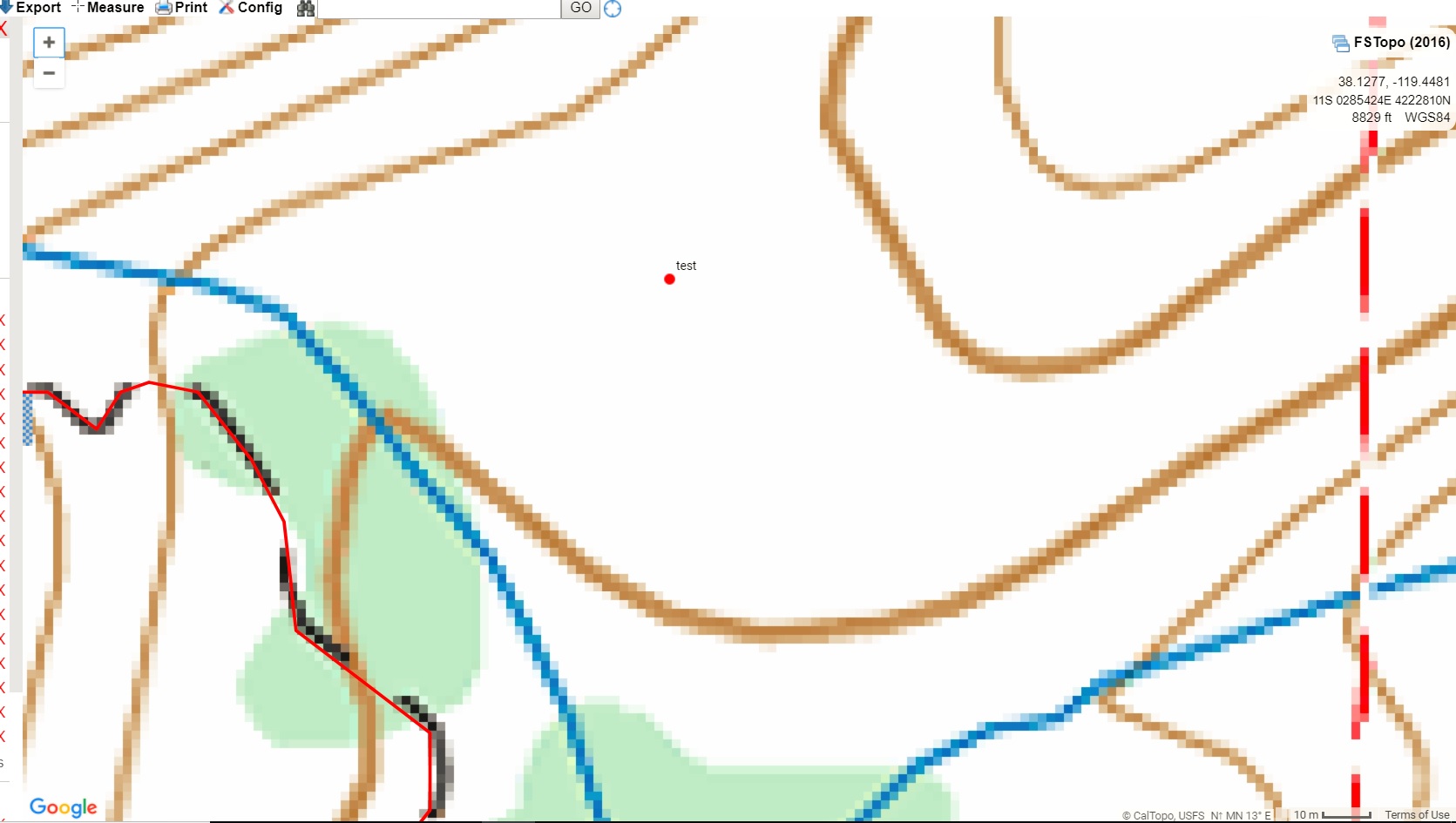
Point on Caltopo using USGS Topo Map. Notice red dot with the label “Test”. Contour lines are at 40′ intervals.
Here the same spot gets viewed on caltopo using the “Satellite” layer. Zoomed to the maximum allowed.

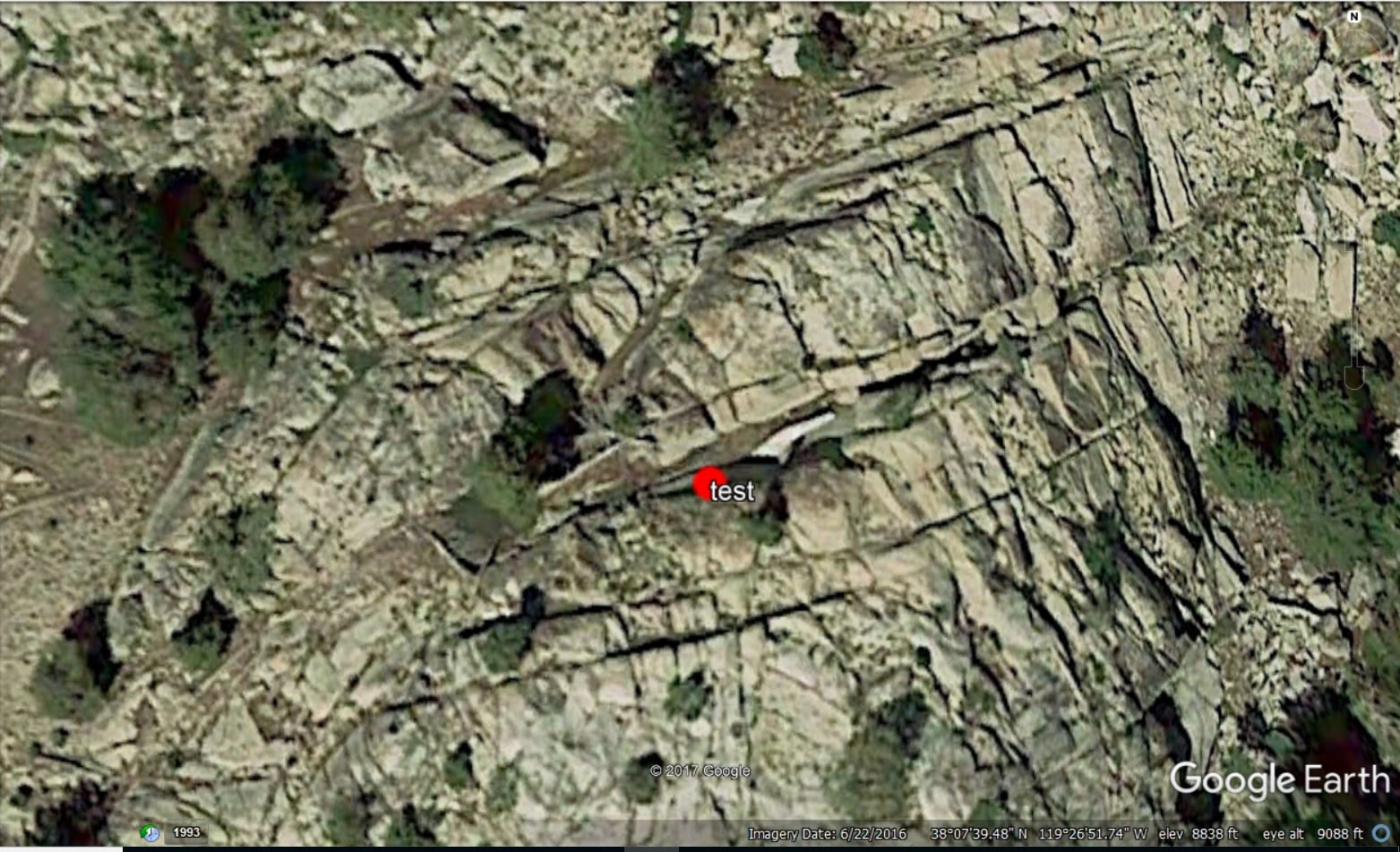
Now lets switch to Google Earth. Same spot viewed from top, allows “deeper” zoom level than the satelite image on caltopo…
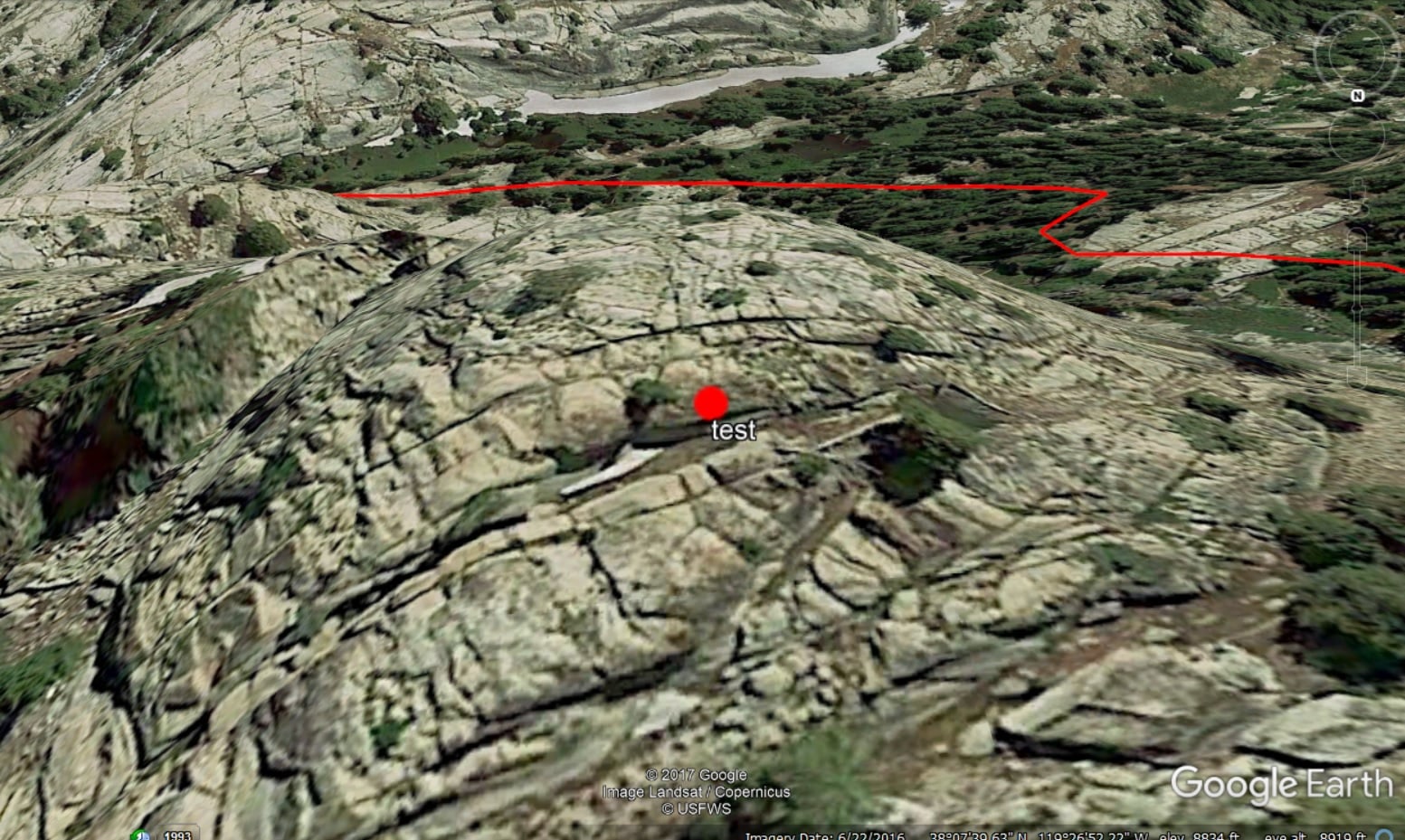
But the main advantage of Google earth is that you can see things from different angles (3D), and not just from top. Here is a better picture of that dot.
I too use Google Earth, saving edited screen shots and sending them to my iPod for use in the field. It takes a couple of iterations to get things right, but once accomplished the zoom feature provides the necessary detail to figure out stuff.
It is very reassuring to match a distant pass with “image 1”, and then use “image 2” to get to the top.
I’ve found “micro navigation” in difficult terrain to be a skill unto it’s own, especially in rocky terrain like you find in the canyon country of western CO and the CO Plateau. The best maps will let you know where you are at and keep you from getting lost, Google Earth can help you pick a route that “may” go, but reality is that a lot of rim and wash walking are often necessary to get in and out of the canyons. With time, you get used to the layers, understand which ones form ledges, walls, ramps, etc. Trip reports and photos from someone who has gone through the effort already are the most valuable resource, but can be tough to come by.
Great area. Enjoy!
I really appreciate the input folks. Thanks to all who responded!
Are you sure the contour lines are 40 feet? Many USGS maps now use 20 meters, which is 65 feet! I have a couple USGS 7.5 topo maps with 80 foot contour lines!!
I have seen (and used) adjacent USGS maps for off trail hikes in desert canyons that had different contour intervals.
The problem with some of these computer systems is they stitch together maps and you have to watch the elevation markings on the contour lines, especially if the map margins are not made visible .
Also in canyons the terrain is constantly changing with rain and floods and many USGS maps are decades old.
I have found that the paper USGS maps work well for me and a full 7.5 map provides the needed perspective when judging terrain.
Here is a blog post I wrote last year noting several of the inconsistencies between different versions of USGS topo maps.
Unless you commission a surveyor you are unlikely to get a better topo map than what you describe. So yes, you sort of have to interpolate a bit, and Google Earth helps.
Isn’t half the fun of canyoneering the routefinding, though? If you want predictable, stick to trails.
Become a member to post in the forums.
 New Ultralight ShelterFreestanding silpoly shelter for lightweight adventures.