Topic

GPS Advice – Recommendations

  • This topic is empty.
Viewing 25 posts - 1 through 25 (of 36 total)
Turley BPL Member
PostedNov 22, 2014 at 5:17 pm

I've always solely used a Map and Compass for backpacking/hiking but have had an eye on purchasing a GPS.
I'm currently looking at the Garmin Oregon 600 and eTrex 30 Models, and for the most part, seem to prefer the former for its touch screen and menu.
Any advice regarding the pros and cons between these two (seem similar except screen) would be appreciated.

Cheers and thanks

jimmy b BPL Member
PostedNov 22, 2014 at 7:19 pm

I have an Etrex 20. I used it at first as a speedo for small boat sailing. Took it day hiking many times for toying around & checking mileages. I don't usually take it on well traveled trail like the AT and Adirondacks around here but I did take it on our BPing trip to Zion this year. Only used it once to confirm my position on my map and I dropped in way points at water source coordinates. I chose it at the time because it uses the Russian sat system as well. It has a ton of little tools, some handy like MOB marker and anchor alarm for on the water. Lots of interesting yet not that necessary stats. I did use the area calculator to estimate Lime needed for my lawn :)

I find it very intuitive and easy to use. Its pretty compact and has never failed to get a signal, knock on wood. With base camp software I down loaded a free Zion map overlay and some others out East here. I must admit I'm not much of an electronic geek, I don't even own a smart phone. Out side of it being accurate for location I have learned not to trust GPS maps. To many screen shots from sailors where the GPS showed water where the land was and vise versa. In this manner GPS mapping has been suspected to have contributed to some deaths from grounding without an active watch. Showed me once walking through the middle of a lake, funny, didn't get a bit wet.

In general I find GPS coordinates very useful paired with a good map but I would sacrifice the other features for a device much smaller/lighter that was equally as accurate for coordinates only.

jimmyb

Bob Gross BPL Member
PostedNov 22, 2014 at 7:24 pm

"I chose it at the time because it uses the Russian sat system as well."

What does that do for you?

The problems with GPS maps that you mention are typically not the problems of maps, but more the problems of the receiver itself. Due to the weaknesses that we have discussed here, nearly all GPS receivers will have some temporary problems from time to time.

–B.G.–

Turley BPL Member
PostedNov 23, 2014 at 7:29 am

Thanks for the above info……
Additionally, is the preloaded microchips or discs preferred?

PostedNov 23, 2014 at 8:50 am

I have the Etrex 20 (my first GPS). A few things that took me a while to figure out…

1. GPS drift. When you’re sitting still, the odometer keeps incrementing. Not nearly as much as when you’re hiking, but it does increment. That’s pretty normal as explained here.

2. When I arrive at the start of a hike, turn the Etrex 20 on and reset it, it will often include the drive from home. It needs to be reset AFTER it locks into the satellites and starts incrementing distance, etc.

3. The elevation reading usually seems pretty good but can be way off wonky at times. The Etrex 30 has a barometric altimeter which is supposed to make the elevation reading more accurate. Dunno the extent to which that’s true. The Etrex 20 relies only on the satellites for an elevation reading. The worst was a bike trail in heavy forest. I was waaay below sea level for a while. I assume it was unable to lock into enough satellites to accurately get my elevation. The elevation readings have seemed OK on most hikes.

Overall, after figuring some things out and adjusting my expectations, I’ve been pretty happy with it.

jimmy b BPL Member
PostedNov 23, 2014 at 8:57 am

My choice would be disks for my Etrex. If my chip is damaged ,as per Garmin, it will not be replaced. With the disk I can simply reload the info. YMMV.

jimmyb

Mike W BPL Member
PostedNov 23, 2014 at 9:25 am

If you want to use the Garmin mapping on your computer then you have to get the disk version. You can't load the media card data onto your computer.

I prefer the Etrex as the touch screen Oregon can be problematic in cold weather (slow response and glove issue).

Richard May BPL Member
PostedNov 23, 2014 at 11:02 am

So, this thread drifts…

I have the eTrex 10. It's fast to lock position and isn't as affected by foliage as the one it replaced. Both can be attributed to newer receiver technology, regulations that allow better accuracy of civilian GPS and the dual satellite feature.

I use it to log trips, geo-tag images and to triangulate my place on a map. For that this device is perfect.

GPS altitudes are calculated differently from maps. So there's always a discrepancy to account for. A barometric altimeter like in the 30 probably fixes that, but I don't know for sure. If anyone can give me a good explanation of the discrepancy that'd be great.

Stuart R BPL Member
PostedNov 23, 2014 at 2:09 pm

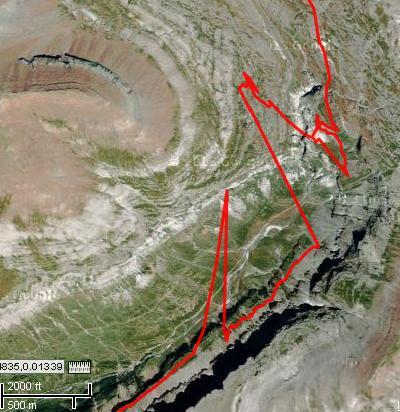
"nearly all GPS receivers will have some temporary problems from time to time."

Like multi-path interference, which can put your position a mile or more from actual

Ordessa track

Bob Moulder BPL Member
PostedNov 23, 2014 at 2:22 pm

The Etrex 30 altimeter works quite well when in auto calibrate mode.

It recalibrates itself when the barometric reading is at significant variance with the GPS altimeter, WHEN the GPS signals are strong and reliable, and there are enough satellites to ensure the triangulation is correct.

There are those here at BPL who know a lot more about the technical details of how it works, but in my experience it is a pretty much "set it and forget it" function that will be pretty darn close almost all the time. I don't know if the Russian GLONASS satellites hurt or help this process, so it would be interesting to get some expert input on this.

Years ago I was standing on top of Humphreys Peak in AZ (12,635) with an older Garmin Vista (also with alti auto calibrate) and the altimeter was dead on. I looked at the satellite page and all 12 bars were solid black. Don't see that very often!

PostedNov 23, 2014 at 2:27 pm

"If you want to use the Garmin mapping on your computer then you have to get the disk version. You can't load the media card data onto your computer…."

I'd have to quibble with that. I bought the media card version of the Garmin Western Canada Topo maps. When I connect my Etrex 20, it uploads and displays those maps in Basecamp.

PostedNov 23, 2014 at 3:39 pm

So, in terms of altitudes…

First, there is the ellipsoid, a nice smooth shape that is based on the hypothetical equipotential gravitational surface. This would be convenient if you were flying a spacecraft, or a satellite, and a basic GPS-calculated altitude may be the height above ellipsoid (HAE).

Second is the geoid, which is an attempt to follow mean sea level (MSL), and approximate that same level over land. Now, even though you might expect sea, being liquid, to fill the oceans to the same level everywhere, that's not the case. The sea is smoother than the land, but still undulates on a global scale. Good GPS devices will use the location data to convert the HAE number to a geoid-based altitude.

Third is the barometric altitude, which will also vary according to local temperature and air pressure. GPS devices with a barometric altimeter can report this number in addition to the GPS altitude, and use the GPS altitude to calibrate the barometric altimeter.

The geoid and ellipsoid ideas of "0 altitude" can vary by +85/-106 meters. The barometric altitude can vary by even greater amounts. If you calibrate your altimeter at your local sea-level REI, which it's balmy 59F outside, then head up to the mountains and catch a 0F cold snap, your device might think you are 250 meters higher than you really are. This means with a barometric altimeter you want to be calibrating it fairly regularly.

Side note: this is also why aircraft use "flight levels" above a certain altitude; rather than worry about properly calibrating their altimeters, they base the calibration on a standard model. Exactly where the ground is doesn't matter, all that's important is that the altimeters on any nearby planes are "off" by the same amount.

-Jeremy

Bob Gross BPL Member
PostedNov 23, 2014 at 4:20 pm

"GPS altitudes are calculated differently from maps. So there's always a discrepancy to account for."

Primarily that is because GPS altitudes are not calculated from maps.

When a basic GPS receiver has three or more satellites in view, it can calculate its 2-D location. When it has four or more in view, it can calculate its altitude as well. Now, the altitude is not as precise as the 2-D location. At the very best, the vertical dilution of precision is 50% worse than the horizontal dilution of precision. At the worst, it could be several times worse.

So, if your horizontal error would be 5 meters, then the vertical error might be 7.5 meters or more. Even that assumes that everything else is normal.

A barometric altimeter has nothing at all to do with GPS reception. A good GPS receiver with that barometric altimeter has to do some interesting guesswork to know when to take the barometric calculation versus when to take the GPS vertical calculation. There is a lot of heuristics going on, and that is all proprietary.

–B.G.–

Bob Gross BPL Member
PostedNov 23, 2014 at 4:25 pm

Stuart showed an excellent example of what you see when multipath interference is in the mix. Now, if the human can study that track and figure out what is the practical solution, that is good. Some GPS receivers can start to do that a little, but not much. The other alternative is to use a GPS antenna that is not so susceptible to multipath.

If you have a very good receiver, you can change the reception mask angle, but you probably would not want to do that unless you saw a wonky track like this to give you a strong suspicion of multipath problems.

–B.G.–

Bob Gross BPL Member
PostedNov 23, 2014 at 4:32 pm

"I don't know if the Russian GLONASS satellites hurt or help this process, so it would be interesting to get some expert input on this."

Prior to a few years ago, the Russians were having lots of problems with their satellite constellation and its maintenance. Back then, GLONASS was probably more of a hindrance than an asset. Then they got it together. Now, you could probably use GLONASS to get a good position, or you could use GPS equally. I doubt seriously that there is any advantage to using both simultaneously. In the event of global thermonuclear conflict, both are going to be affected somewhat. The Russian economy is a little bit unpredictable right now, so I don't know what will happen to GLONASS. It takes a lot of money to maintain the infrastructure.

I stood on the highest peak in the entire western hemisphere, so the view of the sky was perfect. My oldest GPS receiver was accurate to 1 meter there.

–B.G.–

Robert Blean BPL Member
PostedNov 23, 2014 at 4:38 pm

My understanding is that GLONASS does a better job of covering the far north than GPS does. I would expect that a GPS receiver that can use GLONASS might be the better one for things like an Arctic canoe trips.

–MV

Richard May BPL Member
PostedNov 23, 2014 at 5:22 pm

“A good GPS receiver with that barometric altimeter has to do some interesting guesswork to know when to take the barometric calculation versus when to take the GPS vertical calculation. There is a lot of heuristics going on, and that is all proprietary.”

LOL so it calibrates and is synched with the GPS but still not the map?

From my rudimentary map skills I recall that one should calibrate an altimeter when at a known location and at a known altitude.

Now I’m really curious. I would hope that since the GPS has topo maps loaded, it would use the three data sets to calibrate altitude… other wise it you could run into the kind of problems Rodger faced.

Mike W BPL Member
PostedNov 23, 2014 at 5:34 pm

>> I'd have to quibble with that. I bought the media card version of the Garmin Western Canada Topo maps. When I connect my Etrex 20, it uploads and displays those maps in Basecamp. <<

Viewing the maps while the GPS is connected does not upload them into BaseCamp. They will only be there while your device is connected. As I said in my post, if you want to load the maps directly onto your computer for use with BaseCamp or Mapsource, you have to purchase the disks.

This is explained here:

https://support.garmin.com/support/searchSupport/case.faces?caseId={16315fb0-39b2-11de-5dd5-000000000000}

Katherine . BPL Member
PostedNov 23, 2014 at 6:05 pm

curious why you want to move to GPS? (and maybe that would influence the recommendations…)

anything more ambitious that what you could do with one of those smart phone apps?

Bob Gross BPL Member
PostedNov 23, 2014 at 6:28 pm

"LOL so it calibrates and is synched with the GPS but still not the map?"

I can't parse your pronouns.

"Now I'm really curious. I would hope that since the GPS has topo maps loaded, it would use the three data sets to calibrate altitude."

Which three data sets are those?

When a GPS receiver has a good signal lock, it computes Position, Velocity, and Time. The position is normally a 3-D computation, and that is done purely off the satellite signals and has nothing at all to do with any base map that your receiver may or may not have inside. In other words, it cannot "read" the numbers or contours of a topo base map.

Some receivers have a better topo base map that includes DEM data. So there the map actually feeds elevation data over to the screen display. Note that this doesn't do you much good unless you are traveling on the surface of the Earth. Aircraft need a better way.

Now, what would you put the most faith in, the GPS elevation, the barometric elevation, or the DEM elevation off the map? There is no perfect answer to this.

–B.G.–

Richard May BPL Member
PostedNov 23, 2014 at 7:30 pm

> "I can't parse your pronouns."

Fair enough. I'm only talking about the altimeter. Altitude can be measured in three ways as described by Greg and Angela above: ellipsoid, geoid & barometric. So the barometer can be calibrated to sync altitude with ellipsoid or geoid but not both since they each reflect different ways measuring altitude.

The three data sets on the GPS would be: the GPS altitude determined from satellite triangulation; the altitude indicated on the internal map; and current air pressure.

> "Now, what would you put the most faith in, the GPS elevation, the barometric elevation, or the DEM elevation off the map? There is no perfect answer to this."

Exactly.

Personally, I want the altimeter to match the map in my hand… but then I still believe in paper.

Robert Blean BPL Member
PostedNov 23, 2014 at 7:40 pm

"Personally, I want the altimeter to match the map in my hand… but then I still believe in paper."

Absolutely! My ideal is for the GPS map, the paper map, and the reported altitude to all agree.

–MV

Bob Gross BPL Member
PostedNov 23, 2014 at 8:04 pm

Think about the crew of a nuclear submarine. They can't rely purely on GPS, because they can't easily get a GPS fix when submerged. They can pop a trailing wire with GPS on the end, and it floats to the surface to get a fix. But, that isn't foolproof.

Although submarines can use ocean bottom maps, they can't be used quite the same way as a hiker uses a topo map.

Submarines can use star maps, but they have to be close to the surface for that also.

In general, submariners rely on an Inertial Navigation System with atomic clocks. All of that uses a fair amount of power, which a nuclear submarine has readily available. A hiker does not unless he has ten or twenty square feet of solar panel over his head.

–B.G.–

PostedNov 25, 2014 at 1:05 pm

FWIW, just got an e-mail from REI previewing their "Black Friday" sale, and will have the eTrex 30 for 40% off ($160).

Brendan S BPL Member
PostedNov 25, 2014 at 1:26 pm

I use a etrex 20 for work and like it. Coworkers use probably every other Garmin model from the last 10 years and I've never had any gps envy for other models. Hits the sweetspot of price/size/weight/usability.

Viewing 25 posts - 1 through 25 (of 36 total)
Loading...