Probably a question asked a million times but the last time I had a gps it my hands it had black and white screen and could never find a satellite. Ok this was about 15 years ago and I know they have come a long way since then. What I'm looking for is a little help on finding a GPS that I can upload my gps data to a software program for a mac. I would like to make detailed trail maps showing my different routes. does something like this exist. Thanks for any input
Topic
GPS help
Become a member to post in the forums.
- This topic is empty.
Here's an old thread that helped me out.
I use Caltopo to make my maps. I create my waypoints on Caltopo and transfer them to my GPS. I always carry maps so I don't worry about having mapping capabilities on my GPS so I can't help you there.
If you carry an iPhone, you can download the Gaia ap. When I had one, I'd download the map large enough to cover the area I was traveling through. For example, when I was on the Wonderland, I downloaded the entire Rainier NP. Didn't eat up too much memory and you can delete the file later if you need to.
http://switchbacks.com/ has good maps to download to GPS
free
only for Pacific Northwest though
shows trails more accurately than other maps
never mind. LOL
A Garmin GPS would be a good choice as you can download and use their mapping software (BaseCamp) with a Mac.
You will have to buy the mapping software to make decent maps but if you buy a mapping GPS you'd want that anyway. Free mapping software is available for the GPS but it won't work in BaseCamp (I don't think…), so buy some Garmin mapping software with the GPS (but make sure you buy the DVD version not the preloaded SD card if you want to use the mapping on your computer).
Here's a few samples of what you can do (I have purchased Garmin's Topo and BirdsEye Imagery).
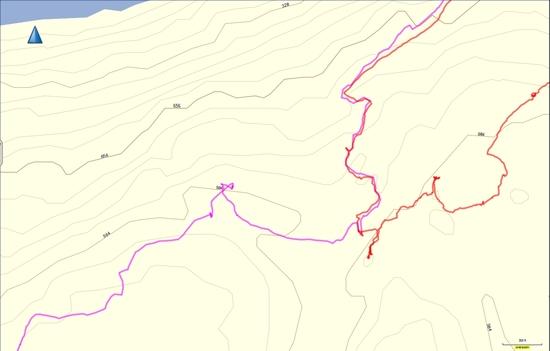
This is BaseCamp with Garmin's Topo Mapping (and some tracks).

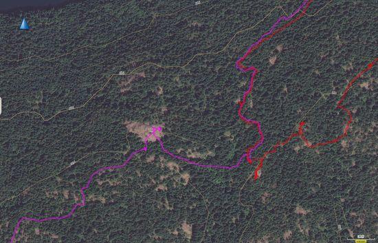
This is Garmin BirdsEye Imagery in BaseCamp (Same Area with tracks)

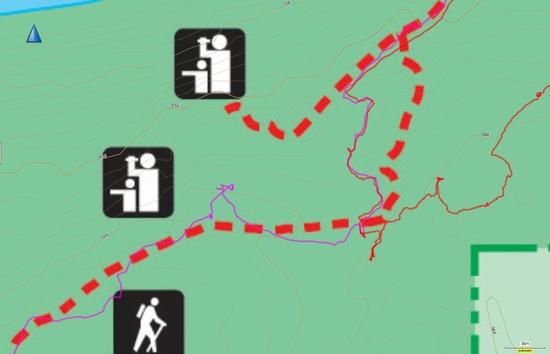
This is a Custom Park Map overlayed in BaseCamp (Scanned a PDF and Georeferenced to fit the Garmin Topo Base) – same area with tracks (note the parks map shows the trails, lookouts etc)

Note that the Garmin Topo contours show through on both the BirdsEye Imagery and the Cusom Map (that's a nice feature).
Awesome Mike, Thanks!
More expensive GPSes like Garmin 60CSx (which is probably obsolete now?) have better antennas and electronics so they keep a signal better in canyons or under dense forest. Even with them the signal may drop out occasionally.
The cheaper ones are still usable. You can estimate pretty good where you are and eventually it will get a signal again.
If you want a good track of where you've been, then the more expensive GPSes are better. The cheaper ones are still good if that fits into your budget better.
Another useful app on the Mac (as well as Linux or Windows) is GPSBabel. It’s a general purpose converter between various data formats – in particular, I use it to slurp in tracks from my Garmin Foretrex and put them out in Google Earth compatible format. This gives you the flexibility to see them with all sorts of overlays.
What Mike says is good stuff, but the fact is that Garmin Maps suck… bigtime.
If you want really detailed topo maps that look like USGS topos, the Garmin maps will not cut it.
However, you should be able to find a good topo map program and then upload the GPX files from your Garmin to that map program.
I'm not sure how to do that on a computer.
But what I have done is to upload the GPX files from my Garmin to the BCN (Back Country Navigator) app on my Android powered tablet using a computer running Base Camp by Garmin.
I can also use the tablet running the BCN app to set waypoints for a trip and then load those waypoints onto my Garmin.
All of this is way more complicated than it should be. Garmin does not help as they seem to make it difficult for their hardware and software to work with any other stuff.
You might look at the Delorme GPS offerings as I believe that at lest some of their GPS units run the National Geographic top maps which are great.
Or just forget a dedicated GPS device and get a smart phone that has GPS and topo apps.
This may be the simplest approach… but not sure if the smart phone apps will print to paper maps. All of this is still a bit of the Wild West, and likely to get easier as time goes on, my guess.
Billy
>> the fact is that Garmin Maps suck… bigtime <<
I won't disagree with this statement and having a variety of map sources when planning trips is really what you want (I do). But after years of trying to put together the perfect set of mapping and GPS tools I finally decided that having a printed map "in hand" on the trail that agree with my GPS is invaluable (relating the screen display to the map). I do take additional hard copy maps as well but find the convenience of the integrated Garmin maps a real plus in their favour (even if they are less accurate than I would like).
I would also point out that it depends on where you are… I've read terrible reviews of the Garmin BirdsEye imagery but in the areas I hike in I find the imagery pretty good. The same goes for the Topo. I suspect they have many sources of mapping when they put together mapping for all of North America and in some areas the quality of mapping will be better than others.
One of the things I realized a few years ago when I was building a custom map for my Garmin was that Garmin actually strips out detail from their mapping to keep the screen display clean. I overlayed their topo with a drainage layer that I had access to and found that there were thousands of rivers and creeks on my drainage layer that didn't show on the Garmin map data. The interesting thing was that Garmin's contour data (topo) matched my drainage "exactly" but the Garmin mapping didn't show the rivers and creeks (they had obviously been removed so that the tiny GPS screen wasn't too cluttered).
Everything stated so far is true. You just have to decide what you want and what you need in GPS mapping. Some users want to keep it very simple, so the map display has all sorts of information stripped out. This keeps the data from overloading the display and the electronics supporting the display. This makes it quicker, but the user still has to interpret what is displayed and relate that to the real world in front of the eyes. Other users want everything that they can get on the display. This is OK, but it requires a more expensive/newer GPS receiver that draws more battery power.
In my opinion (having started working in the GPS industry in 1994), if you are forced to use proprietary topo maps that you have to pay money for, you are doomed.
–B.G.–
switchbacks.com has a great Pacific Northwest map, but just barely gets into California
24K level of detail on topo contours
more accurate locations of trails is nice
My experience with the Garmin 24K topo maps is that they definitely do NOT suck. They are fantastic, at least where I hike with them — mostly in the White Mountains.
The routable trail locations aren't always completely accurate, nor are they on any topo maps that I've see. For that, I download actual GPS tracks for the trails and display them on top of the topo maps.
Here's an example:
http://i218.photobucket.com/albums/cc14/hwc_1000/gps_eisenhower_zpse18cff77.jpg
The current Garmin handhelds — Montana, Oregon, etc. — allow easy use of third party topo maps. I have several installed in Basecamp that can be easily copied to and used on the Montana. The only one I use is a Trails.com map with nothing but GPS tracks of hiking trails in the US.
How do the third party maps get the registration right for a particular GPS receiver?
I mean, if the map is just a JPEG image, then that is only partly OK. But the GPS receiver determines your coordinates (lat/long, or whatever), and it needs to show that hovering over the map image in the right spot.
I'm just curious.
–B.G.–
I don't know how they do it. I just know that I've got two different third party (free) topo maps for NH, plus the Garmin 24K high-rez topo maps. I can select any of them (like selecting layers) and my GPS tracks superimpose properly. I also have a Trails.com map that is nothing but red line GPS tracks for all the National Parks in the country. That can be displayed transparenty on top of the Garmon topo map, so I see the topo map, the Trails.com red lines, any of my previous GPS tracks, and my current GPS track. They all superimpose properly.
The Garmin 24K topo maps are routable in the same way that roads are routable on a car GPS. I used that feature for playing around with possible hikes in Acadia National Park. Worked great. It's not perfect (because the trail locations on topo maps are not GPS-accurate), but in a well-mapped place like Acadia is was close enough. I could route from trailhead to summit or by placing waypoints on the map. Do all the planning on the computer at home and then transfer it to the Montana.
For the original poster. If all you want to do is record your GPS track and then transfer that to a mapping program on your computer when you get home, then you can do that perfectly well with any of the recent generation GPS watches — Garmin Forerunners. Garmin fenix, Ambit GPS, etc. I have used three generations of Garmin watches (Forerunner 405, Forerunner 610, and fenix 2). For all intents and purposes they are all every bit as accurate recording my GPS track as the MOntana handheld mapping GPS. They all work very well.
The uploaded tracks can be displayed on any number of computer programs Garmin Connect on line. Garmin Basecamp. SportTracks. MapMyRun. Google Earth.
Here's a GPS track I recorded on my fenix 2 watch last week in Acadia National Park, displayed in Google Earth:

"My experience with the Garmin 24K topo maps is that they definitely do NOT suck. They are fantastic,"
You must live in a different universe than me then. Those raster maps that Garmin uses show little of the detail that you get on a USGA topo map… streams, meadows, vegetation/tree line, shading, USGS grid, etc… … all left off by Garmin… presumably to save space and get by with smaller chips…
billy
Yep. Must be a different universe. I actually use the 24K Garmin Topo maps. Here's a sample of the Garmin map installed on my Montana GPS. Small chips are really not an issue in the current universe. My Montana has a 4G internal storage plus a 32G SD card. I have the 24K topos for the entire Northeast and Southeast US installed with nearly 24G still free. I could probably install the entire US. "Small chips" are not a limitation…

I don't generally use it, but if you want even more detail, you can superimpose the 24K Garmin topo maps on satellite imagery. Here is a detail from the same hike as it would appear on my Montana handheld, if I had the sat imagery layer turned on. I think treeline can be seen pretty clearly on this view.

I hike with the first view above: the 24K topo map with a GPS track of my hike super-imposed so that I can easily see if my new track follows my intended route properly.
I carry the crazy good AMC White Mountain paper topo maps as a backup, but hardly ever refer to them, except for something like identifying a distant peak.
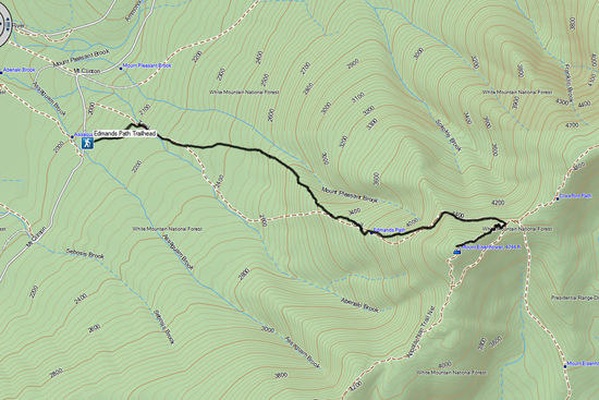
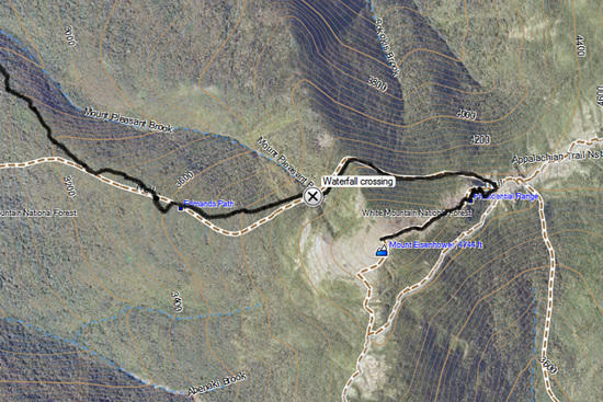
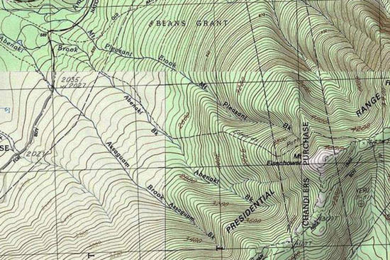
Here's a comparison of the same trail on the Garmin 24K topo maps and the USGS quad topo map, both showing 40 foot contour intervals:
Garmin 24K

USGS topo:

Keep in mind that I can carry the entire US topo map, at 24K resolution, in my handheld Montana GPS.
Interesting to note that both show the same, incorrect, location of the first part of the Edmands Path trail compared to the actual GPS track location (black track on Garmin map).
>> How do the third party maps get the registration right for a particular GPS receiver? <<
Recent Garmin devices allow you to add custom map images to your GPS. The process of registering an image is fairly straight forward if all you want is a referenced image of a smallish map. First you create a Jpeg of the map you want (I typically convert the PDF files to Jpg files using Photoshop.). Once you have the map saved as a jpg image, you take the image into Google Earth and Geo-reference the jpg (by fitting distinguishable detail on your custom map image to the Google base map). Then you save to your device and it will display correctly on your GPS with tracks and way points and the location pointer all sitting on top of the custom map.
Detailed instructions from Garmin shown here.
Edited to fix link.
I’ve never had to do any of that. Garmin is such a widely-used standard that there are tons of free map downloads that install seamlessly on Garmin units. Here’s a site with a bunch of Garmin topo maps:
Garmin Basecamp also imports (and exports) Google Earth KMZ files.
I use a Garmin Oregon with their 24K Topos and load a few of the GPS File Depot custom maps for some of the areas I backpack in Montana (better boundaries for private land on them). I like the touch screen interface, so I've passed on the line GPSMap line. I think the sattellite lock/accuracy on the touchscreen models has improved sufficiently that the advantages of the GPSMap line have been minimized now.
Absolutely no complaints here about the Garmin Oregon or the Garmin 24K Topos. The only flaw in the Garmin system is the crappy free maps that come on the devices. You just have to spend $100 each on the Regional 24K Topos for the areas that hike in, or spend the time and effort to search up the freebies that are worth using on the web.
I haven't used the Etrex line of their hardware. So, I can't speak to the cheaper models. But, the Oregon has met me needs perfectly and, if you have the cash to blow, I'm sure the Montana's bells and whistles are nice too.
My tracks are so accurate that, when I backtrack on a trail, the lines are literally right on top of each other.
I have one I'll sell you. PM if interested. Thanks!
Become a member to post in the forums.