Topic

Yosemite area in late May

  • This topic is empty.
Viewing 25 posts - 1 through 25 (of 40 total)
PostedApr 9, 2014 at 9:23 am

Does anyone have any recommendations for a 4-5 day hike in the Yosemite area (actually, anywhere that is easily accessible by bus from San Francisco, as I'll be visiting there) that would be suitable for mid-to-late May? On the NPS website, it said that most of the trails above 7000' would be covered in snow, but I understand that this has been quite a low snow year. Any recommendations would be helpful, thank you!

PostedApr 9, 2014 at 1:30 pm

This hike has the benefits of a loop trail under 50 miles and elevations are pretty low, or you can do it one way with a shuttle bus back to the start. I have to defer to others in the community to comment about the trail as I am going on this loop in Sept for the first time. So, it's less of a recommendation than a suggestion of a potentially good hike!

Bob Gross BPL Member
PostedApr 9, 2014 at 1:38 pm

The Grand Canyon of the Tuolumne trail is good if you can hit it in the right season. I think that it is done best from bottom to top, starting at Lukens Lake or White Wolf, going along Morrison Creek, then ending at Tuolumne Meadows. If the snow is persistent, it will be wet toward the top end. On a normal year, you want to see the waterfalls at the peak of the snow melt flow. However, this year is not a normal year.

–B.G.–

PostedApr 10, 2014 at 12:16 pm

Grand Canyon from White Wolf (Pate Valley) to Tuolumne is a great late May or early June hike in a dry year (I did it last year). Perhaps a couple weeks later is best in a wet year. There are numerous cascades and side waterfalls all the way to Glen Aulin.

But I don't think the buses run that early. YARTS (http://www.yarts.com/schedules.html) shows service starting June 1st. Tuolumne Tours (http://www.yosemitepark.com/tuolumne-meadows-tour.aspx) shows service starting June 20.

If you can get/rent a car, you could park it at the White Wolf entrance (campground won't be open yet) and then hitch a ride back from Tuolumne Meadows. Of course, all this assumes upper 120 will be open then (it should be in such a dry year).

Note that looping around Hetch Hetchy is problematic this year as the Rancheria Falls trail is closed due to a land slide and the downstream half of the reservoir was burned out in the rim fire last year.

PostedApr 10, 2014 at 12:41 pm

I hiked in Yosemite last year at the end of May/1st part of June. The snow pack was a bit heavier than this year and hiking was mostly snow free up to almost 9000 feet. I've not been there mid-may in recent years.

For bus access, you might consider Happy Isles to the Illilouette area (some dates show open for permits at http://www.nps.gov/yose/planyourvisit/upload/fulltrailheads.pdf). Or you could try for a walk up permit for HI to Little Yosemite Valley (reserved permits are mostly sold out). The Illilouette area is mostly under 7000 feet and the LYV trail hits ~7200 feet at Merced Lake. There are lot's of loop possibilities south of Illilouette.

Other areas you *might* be able to bus to and backpack are Point Reyes (north coast from SF) and Big Sur (south coast from SF). Also, Tahoe could be worth considering, lot's of busses from the Bay Area go that way.

PostedApr 10, 2014 at 4:23 pm

Thank you all, it seems like the Grand Canyon of the Tuolumne trail is a good choice–although it may be slightly problematic to get to the White Wolf trailhead from Yosemite Valley (I checked Amtrak, and there is bus service to Yosemite Valley from San Francisco on the dates that I am considering). It looks like it might be possible to hike up to White Wolf from the Yosemite Falls trailhead, although it would add ~10 miles (just from eyeballing it).

In any case, thanks again, since now I feel confident that there will be some good hiking to be had in the area in mid-May (whereas the NPS site makes it seem as though there is very little that is open during that time).

By the way, if anyone is using this as reference, this is a very helpful trailhead map: http://www.nps.gov/yose/planyourvisit/upload/wildernesstrailheads.pdf

PostedApr 10, 2014 at 4:24 pm

Tahoe is a great recommendation for a place accessible from SF, but unfortunately I've hiked in Desolation Wilderness a couple of times in the last few years and want to chart some new waters.

PostedApr 14, 2014 at 7:59 am

I should add that the side stream coming from Mattie Lake just above California Falls tends to flood the trail in May/June. You may need to wade ankle deep for ~300 yards. Barefoot is doable, but you may want Vincere grip socks or a water shoe.

Also, if you plan to hike back to the valley via Murphy Creek/Tenaya/Olmstead/Snow Creek, the trail junction to Murphy Creek hits ~8700 feet on a north slope. That area was about 1/3rd snow covered last year the first week in June, so you might want to have microspikes or something if you try it in May. The alternative May Lake trail rises to over 9300 feet, so that may have even more snow.

Paul Koenig BPL Member
PostedApr 15, 2014 at 1:12 pm

Brendan, reply back to this thread following your adventure, as I and many others will be watching for first hand snow reports. Also, I've read many good things about the Grand Canyon of the Tuolumne trail.

Depending on how fast the snow melts, an option to have in your back pocket might be the Red Peak Pass loop, leaving either out of Glacier Point, or Mono Meadow trailheads. I've read many people on this site rave about this trip, although it might be quite a challenge if the snow lingers.

I'm headed to Yosemite June 4th – 9th, and I was considering a dayhike across the North Rim. Up Yosemite Falls, across to North Dome, and down Snow Creek, back to the Valley? 17 miles or so … I struggled to find any trip reports for this dayhike … should I take that as an omen to avoid this? It looked like a worthy alternative to the Mist trail's half dome crowds.

-Paul

Bob Gross BPL Member
PostedApr 15, 2014 at 1:52 pm

Another good North Rim dayhike is the western part, El Capitan to Yosemite Falls. The problem is that the far western access is from either the New Big Oak Flat Road (that runs from Crane Flat to the valley) or else from Tamarack Flat Campground, and it may or may not be open when you need it.

I used to lead a group backpack trip every year, and we would start from Tamarack Flat and camp near El Capitan or just slightly west. Then, for a layover day, we would like from camp to the top of Yosemite Falls and then back to camp. That was always good.

One year, we were hiking to the top of Yosemite Falls when one of our women hikers asked me to loan her five bucks. I thought for a second and then asked where she intended to spend that money. She said that she wanted to buy ice cream. Apparently she expected to hike down to Yosemite Valley, buy and eat ice cream, then hike back up to the top of Yosemite Falls, and then hike all the way back to our camp… that day. Reluctantly, I gave her some money, fearing the worst.

The rest of the group hiked back to camp by 4 p.m, had happy hour, and cooked our meal. Finally, at dark this gal came limping back to camp. I asked her if she had gotten her ice cream, and she had. She bought it at Glacier Point!

That is an awfully long day.

–B.G.–

PostedApr 15, 2014 at 3:31 pm

Thanks all for the replies. I bought my flights and now have set dates: May 15 – May 20 (6 days, though I wouldn't be able to start hiking until ~1-2pm on May 15 and need to be out by 4pm on May 20 due to the bus schedules). I will definitely report back on conditions and the hike overall once I am finished.

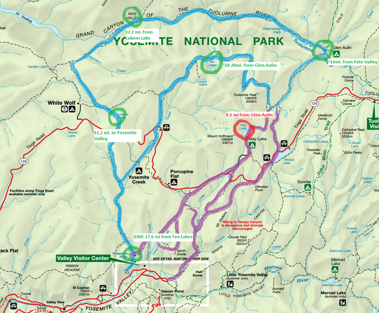
I haven't taken the time to carefully calculate all of the mileages and elevations, but I sketched out a few options based on the feedback I've received. The blue is the main "Grand Canyon of the Tuolumne River" hike as I understood it, and the purple is some alternative trails back to Yosemite Valley (it looks to me that it would possibly be shorter, though it seems that it may be higher elevation and potentially snow-covered). Worst case scenario, I can take it slow and hitchhike back to the Valley from Tuolumne. Or, worser-case scenario, I just play it by ear and schlep around whatever trails are traversable for 6 days.

I am planning on hiking the PCT next summer (2015), so I'll invest in some microspikes and the snow travel aspect of this trip will be a good warmup. I'm not too concerned with wading through stretches of ankle-deep cold water enough to bring any special gear for it–I always just bring socks to swap out (or wear my shoes with no socks on for a stretch so I don't soak a pair).

I think this itinerary looks doable in the time that I have (assuming conditions are cooperative), though it is slightly ambitious

path

Bob Gross BPL Member
PostedApr 15, 2014 at 4:01 pm

I noticed your blue line. If I understand it, you plan on camping overnight at Lukens Lake. That won't work, and one of my ranger friends routinely writes citations for people who camp there. It is too close to the highway, so it is out-of-bounds for an overnight stay. If you continue toward Morrison Creek, it is legal.

By the way, Morrison Creek can be a very risky crossing in early season. I have friends who were injured there. The water can be very deep, very fast, and very cold. Other than that, it's fine. It is especially risky if you are traveling solo, because you can't set up a self-belay.

The trail north of Tuolumne Peak isn't used that much, and in early season it won't be cleared.

May Lake is much less risky.

Delaying by one month would be smart.

–B.G.–

PostedApr 16, 2014 at 9:29 am

Bob,

Thanks for the reply. It's good to know about the Morrison Creek stream crossing–I'm not willing to gamble on risky crossing, especially traveling alone. Will the low snow year make the crossing a bit safer, and are there any alternative ways around it?

The areas that I circled were the trail-distance landmarks that were available on the NPS website, I wasn't necessarily planning on camping at those exact locations, it was just to approximate a few roughly one-day segments.

Unfortunately, delaying is not an option since these dates are the only time that I can visit Yosemite this year, and I will be out there during this time for family business anyways. I have a strong preference for hiking in Yosemite if it's possible, otherwise I could potentially rent a car and go to an area more amenable to early-season hiking (e.g. the Redwoods).

Paul Wagner BPL Member
PostedApr 16, 2014 at 11:13 am

That's a long trip you are considering, and it begins and ends with a very steep section. I am trying to figure out where you are going to stop each day…and I think it is very ambitious for you to do this trip.

First day you start late, and begin with a 3,000 foot climb out of the valley. That's probably about enough for one day. The second day you have a long trek across the north Rim to White Wolf. Say you camp at Harden Lake…because to try to get down the very steep climb into the Grand Canyon of the Tuolumne is a lot to cover.

So then you have three days to hike the GCT. It can be done in three days, but a lot of people prefer four. And at the end of the fifth day you are at Glen Aulin.

No way are you going to be able to get back into the Valley from there in one day—particularly if you are trying to catch a bus at 4 p.m.

And worst of all, once you head down into the GCT, there is no easy option out.

A better route might be to limit yourself to the north Rim…Yosemite Falls trail across to North Dome (two days). North Dome over to Tenaya Lake and then over to Little Yosemite Valley (Three days is enough here) and then down to Happy Isles on the last day.

Bob Gross BPL Member
PostedApr 16, 2014 at 11:30 am

_Morrison Creek_ Will the low snow year make the crossing a bit safer, and are there any alternative ways around it?

The low snow year should make it easier, but that doesn't make it easy. It's hard to predict. I'm not aware of any alternative ways around it.

In past years when we had a whole group, we had the manpower to set up a rope belay at the crossing point.

–B.G.–

PostedApr 16, 2014 at 12:36 pm

I haven't hiked it, but the Google Earth Nat Park trail set shows western access also from the trail opposite the road to Foresta (Yosemite National Park Rd.) along Big Oak Flat Road. The map says 3.9 mi to the Tamarak-El Cap trail. The elevation is from ~4,800 to ~6,000 and you wouldn't need to wait for upper 120 to open. I'll have to try that hike sometime.

PostedApr 16, 2014 at 12:39 pm

The Morrison Creek crossing was trivial on May 30th last year. Of course, you are going earlier and year-to-year variation can be large … I don't recall whether there are alternative crossings.

As someone pointed out, the trail approaching Tuolumne Peak is likely to have a lot of snow as it tops out at ~9,800. There are north and northest slopes along the climb as it nears the trail junctions and heads towards the peak that might have a lot of snow. They were about 50% covered on ~6/3 last year. They show up as forested areas in Google Earth. So I think your purple line passing by Tenaya Lake is the most likely to be passable without snowshoes around May 18th. But you'll only burn another ~2 miles to check out the May Lake and Ten Lakes routes as you'll be able to tell shortly after the May Lake trail junction whether Tuolumne Peak/Pass is worth doing.

Unfortunately, the Harden Garden area (cool botanical area at ~7k below Harden Lake) doesn't really bloom until mid-June.

PostedApr 16, 2014 at 12:43 pm

I haven't done the Snow Creek leg, but the views along the Falls trail, Yosemite Point, and the North Dome sections are terrific. The leg from North Dome towards 120 is mostly pleasant forest hiking. It sounds like an excellent long day hike to me and a decent alternative to the Glacier Point/Illiloutte/Nevada/Vernal 14 miler.

Bob Gross BPL Member
PostedApr 16, 2014 at 12:45 pm

"I haven't hiked it, but the Google Earth Nat Park trail set shows western access also from the trail opposite the road to Foresta (Yosemite National Park Rd.) along 120."

That's the one that I mentioned earlier. It's OK, but there is a lot of up and down and stream crossings.

–B.G.–

Paul Koenig BPL Member
PostedApr 22, 2014 at 12:38 pm

Bob – OH MY GOODNESS!! Ha, I can't tell if your joking or not. That sounds like an incredible jaunt just to score some ice cream. Unfortunately, this sounds like a story YOSAR would we telling.

Onto the dayhike. One thing I really liked about Yosemite Falls – Snow Creek was the ease of transporting us to and from the trailheads. We'll be staying in the Village with a friend so I guess we could drive our rental to Tamarack or NBFOR and then shuttle it back later. I'm also intrigued to catch the views of Half Dome, Cloud's Rest, and Glacier point from North Dome and the Snow Creek descent. It looks like the ascent from the West, less steep, and more drawn out?

I haven't been to Yosemite since I was 7. Which loong dayhike would you recommend for a nearly first time visitor who's ready to see more than what he did from a minivan window last time?

PostedApr 22, 2014 at 1:44 pm

Sorry Bob, I missed that.

Paul, If you've only been through via car, I'd start with the classic GP/Falls loop. You could start at Yosemite Lodge (Green shuttle stop 7). Hike across the valley to the 4 mile trailhead; up to Glacier Point; over to Illilouette Falls; across the panorama trail to Nevada Fall; down to Vernal Fall; and then Happy Isles to catch the green shuttle (stop 16) back to the Lodge (or other starting point). I recall it being 13.5-14 miles. You could cut off a little distance by taking the purple shuttle to the 4 mile trailhead (stop E5).

Or you could try Half Dome (permit needed) if climbing up/down 5k of vertical in one day is not daunting and you don't mind the crowds. Round trip is also ~14 miles.

PostedApr 22, 2014 at 2:02 pm

I received the confirmation for my wilderness permit today, so I'll be starting from the Yosemite Falls trailhead on May 15 (for 6 days). The exact route I'll take is TBD, but I feel confident I'll be able to craft something worthwhile and safe from that start point. I know that some of the outlined routes are ambitious, but I don't think they are unreasonable (and I highly doubt hiking to the top of Yosemite Falls would take me an entire day). I'll post any other questions/updates, as well as a report after I'm done.

Paul Koenig BPL Member
PostedApr 22, 2014 at 2:20 pm

David, thanks so much for the ideas. I'm actually going to be in the area for a week … and I have a permit to hike down from Cathedral Lakes trailhead, up and over Cloud's Rest, with a morning visit to Half dome and descend into Happy Isles. I was thinking about doing the North Rim dayhike following that two night backpack, but I'm rethinking my whole itinerary.

I've actually just posted to the Pre-Trip Planning forum about my whole trip. Check out that post (probably overly detailed) … and let me know your thoughts.

Viewing 25 posts - 1 through 25 (of 40 total)
Loading...