Topic
Trip report: Sierra Trip – Shepherd Pass and Piute Pass
Forum Posting
A Membership is required to post in the forums. Login or become a member to post in the member forums!
Home › Forums › Campfire › Member Trip Reports › Trip report: Sierra Trip – Shepherd Pass and Piute Pass
- This topic is empty.
-
AuthorPosts
-
Aug 15, 2012 at 6:03 pm #1293017
Tom Kirchner kindly agreed to take me into the Kern Basin and show me around – my first trip in the Sierras! Tom's a delightful hiking partner – great sense of humor and an intelligent conversationalist. Couldn't ask for more in a hiking partner.
We both flew into Reno Sunday, Aug. 5, and met at the airport. I figured the old, bald galoot with the wide grin was probably Tom, so I walked up and said hello. I grabbed my bags (Tom had arrived before me) and we got the rental car and drove down to Independence, staying at a local motel that night. Monday morning we were at the trailhead around 7 and headed up the trail.
.

Getting ready to hit the trail!
We were in shade most of the morning, and the temp was cool, which made for a delightful start to our adventure. We moved along at a good pace and still felt strong when we turned to the sunny side of the climb.
.
Getting ready to hit the sunny side of the trail
We hit Anvil Camp around noon and stopped for half an hour – had a bite to eat and refilled our water bottles, before pushing on. It was warm and sunny and our pace slowed accordingly. That last bit of the pass is a bear! Oof! But we crested and stopped for a few pics.
.
.
The obligatory top o' the pass shots!
We headed down the trail, then went off trail to the right to a nice lake, where we camped for the evening. We hit camp around 4 p.m., pleased with how much ground we had covered.
.
.
The trail ahead after cresting the pass
.
Our campsite view
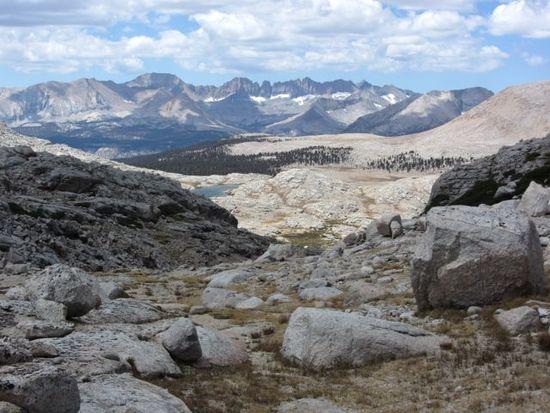
After a leisurely morning (really, all of our mornings were leisurely, we were never in much of a hurry!) we headed uphill and picked up the trail to Lake South America. After passing a small group of mule deer we climbed the pass and looked down on the lake. Gawd I loved the views I kept getting everywhere we went!
.
Looking back before cresting the pass to Lake South America
.
Lake South America
We skirted the lake to the far side and walked some ridges and took a right and walked some more. Heck, I don't know exactly where we were, Tom was leading! I was just enjoying the scenery and the walk and the company.
.
It began raining as we reached the first lake. We walked around it to the left, then around the second to the right, and around a third not in the picture, where we camped
It began raining in the afternoon – fairly light rain, but steady, as we hiked around a couple of lakes. We arrived at our campsite – at the end of the third lake – as the rain tapered off. It had stopped by the time we set up camp. No rain throughout the night.
We hiked on a bit further in the morning – another beautiful, cool, sunny morning (as they all were), then retraced our steps and took the Kern Connector trail to the JMT.
.
Mucking about in the morning
.

The trail to the Kern Connector Trail
.
Tom enjoying a bit of Perpetuem at the top of the first climb on the Kern Connector Trail
.
Since they're not hunted, the wildlife isn't all that fearful of humans
We hiked down the JMT a bit…
.
On the JMT. Storm approaching!
…then as we were coming up out of the woods began bearing slightly left off trail and hiked down some talus to a bit of a valley, up over another rise and then down to Wright Lakes Basin (I believe) where we camped our third night. Once again it rained in the afternoon, complete with thunder and lightning, but stopped just as we set up camp and stayed away overnight. Our plan for the fourth day of hiking was to make our way back to the lake at which we camped the first night, camp there again, and then make our way down Shepherd Pass to finish this portion of the hike.
.
Heading toward the pass that will bring us back to the trail to Shepherd Pass
But Tom developed a sharp pain in his stomach – possible bacterial infection – and the weather really started to turn sour, so we ended up just going down the pass that day, about 19 miles total Tom figures. On the way down the Shepherd Pass trail we could see the effects of the rain and hail we had experienced over the last two days, and on much of the first part of our descent on this day: rock slides had 'washed out' 3-5 foot sections of the trail. We kept a watchful eye on the rocks above us until we got out of that section!
.
Mr. Marmot hanging out, watching us pass
.
Past the danger of rock falls, heading to the final descent of Shepherd Pass
We got to the car around 8 p.m. and headed to Bishop, where we spent two days before heading over Piute Pass. Our plan was simple, go over the pass, make it to Lower Honeymoon Lake and camp there, and then retrace our footsteps the next day, ending our journey. It rained/hailed for much of the hike after we crested the pass on the way down, but not even that could dampen my spirits!
.
Lower Honeymoon Lake. I told Tom not to get any ideas…..
.
My Hexamid Solo performed wonderfully on this trip, even during a pretty hard, enduring rain at Honeymoon Lake
It was not only a fitting end to the journey, but a fitting way to turn 54! Tom bought me a birthday dinner at Mahogany Meats (my choice of restaurant!) – their hot pastrami sandwich is truly outstanding! A truly wonderful trip – I'll be returning to the Sierras, no doubt about that!
Aug 15, 2012 at 6:11 pm #1903041Sounds like the two of you had a grand time walking about in the High Sierra. Thanks for the report and pictures.
Aug 15, 2012 at 6:18 pm #1903043Terrific. What an introduction to the Sierra! Beautiful country. Happy belated birthday Doug. Thanks for the trip report.
Aug 15, 2012 at 6:35 pm #1903048Great stuff Doug! Being your first trip into the Sierra's you picked a excellent area. It really looks dry up there.
Aug 15, 2012 at 6:47 pm #1903053 AnonymousInactive
"Sounds like the two of you had a grand time walking about in the High Sierra."
We did, indeed. I couldn't have asked for a better hiking partner. Doug came ready to party, and party we did. It was one for the books. Thanks, Doug, even if you did turn me down at Honeymoon Lake!
Aug 15, 2012 at 6:55 pm #1903059AnonymousInactive"It really looks dry up there."
It does look dry, Jay, but looks are deceiving. The entire area is laced with lakes and streams, which only show themselves when you get either down in the recesses or up high on a ridge or mountain. Most folks have the same impression when they see panoramic pictures of the area. If you look at the Tom Harrison "Mt Whitney High Country" map, you'll see what I mean.
Aug 15, 2012 at 6:59 pm #1903064..with envy here :)
Sounds and looks like a wonderful time even with the rain and some pain ( since Doug is involved there has to be a rhyme).
Beautiful pictures as well.
I hope to meet you someday Tom and what better place than the mountains.Aug 15, 2012 at 7:12 pm #1903069AnonymousInactive"I hope to meet you someday Tom and what better place than the mountains."
A sentiment I share, Kat, and truly, what better place than the mountains?
"since Doug is involved there has to be a rhyme)."
You should've heard him up there in that thin air. It took his game to a whole different level, and had me in stitches half the time. I finally figured out the stomach pain had nothing to do with bacteria, it was all the laughing. ;)
Aug 16, 2012 at 6:34 am #1903177Great report guys. Doug I am glad you had such a knowledgeable tour guide. I too was at the same lake that you guys stayed at on your first nigh, just a month earlier….courtesy of Tom BTW….now you know why many of us hikers are obsessed with the Sierra Nevada
Aug 16, 2012 at 12:07 pm #1903254I remember that feeling 7 years ago when I made my first trip to the Sierra's. Since then I have made a trip each year to experience the magic of the Sierra's. This year's trip is 36 days away (not that I'm counting or anything).
Doug only thing better than your trip is taking one in mid to late September…
Brad
Aug 19, 2012 at 6:14 pm #1903999Nice looking trip guys. Two men I wouldn't mind meeting on the trail someday.
Aug 19, 2012 at 9:24 pm #1904062Great pictures and commentary. I'm glad you all had a great time! I can't wait to get out there. (Doug, why did you opt for the Hexamid solo for this trip?)
I'm beginning to get backpacking antsy out here in Latvia, where the summer days are drawing to a close and my gear still hasn't arrived yet after our move from the United States.
Aug 22, 2012 at 7:27 pm #1905129I'm heading up Shepherd Pass in a couple of weeks (aiming for the summit of Tyndall). I'd sure appreciate any first-hand recent account of the water conditions between the trailhead and Anvil Camp. I've been up the trail several times in past years but given this year's super-dry conditions I'm concerned that the normal spots where you cross the creek on the way up to Anvil will be dry (and therefore impossible to refill our water bottles at). What's been your recent experience in this regard?
THANKS for whatever info you can provide!
BTW, nice trip report. Great pics.
Aug 22, 2012 at 7:31 pm #1905130"I'd sure appreciate any first-hand recent account of the water conditions between the trailhead and Anvil Camp."
Tom would be a better person to ask, since I'm usually lost in a daze of delight when I'm hiking, but I do know there was at least one spot where we easily refilled water bottles between the trailhead and Anvil Camp, and another spot between Anvil Camp and the summit.
Aug 23, 2012 at 4:46 pm #1905445AnonymousInactive"but given this year's super-dry conditions I'm concerned that the normal spots where you cross the creek on the way up to Anvil will be dry (and therefore impossible to refill our water bottles at). What's been your recent experience in this regard?"
Hi Russ,
In spite of the super dry conditions, the normal first available water source where you cross the creek after losing ~500' was still running when we were there on 8/6 and 8/9; although it was very low, it was still usable as a water source. There is also water available from Shepherd Creek about 1/4 mile or so further on as the trail comes near to the creek. Look for a pathway leading off the main trail when the sound of the creek indicates you are right next to it. It will be before the trail switches back on the long reach that takes you directly above the usual source you just passed, now visible below you on the right. You can also access Shepherd Creek from any of the campsites just off the trail, on its south side, as it passes thru Mahogany Flat.
Aug 31, 2012 at 3:08 pm #1908031Missed a lot while I've been gone. Great report and pictures.
Thanks. -
AuthorPosts


- You must be logged in to reply to this topic.
Forum Posting
A Membership is required to post in the forums. Login or become a member to post in the member forums!
Our Community Posts are Moderated
Backpacking Light community posts are moderated and here to foster helpful and positive discussions about lightweight backpacking. Please be mindful of our values and boundaries and review our Community Guidelines prior to posting.
Get the Newsletter
Gear Research & Discovery Tools
- Browse our curated Gear Shop
- See the latest Gear Deals and Sales
- Our Recommendations
- Search for Gear on Sale with the Gear Finder
- Used Gear Swap
- Member Gear Reviews and BPL Gear Review Articles
- Browse by Gear Type or Brand.
