Topic

John Muir in Late April

  • This topic is empty.
Viewing 25 posts - 1 through 25 (of 27 total)
PostedFeb 1, 2012 at 6:42 pm

After reading about other members experiences with this year's mild winter (i.e. Tahoe Rim Trail in January) I was wondering if it would be possible to complete a John Muir thru hike in late April- early May. I live on the East Coast so I'm not too familiar with what the weather and snow pack has been like out west but if anyone who has been out in the Sierras lately could give me a gage of what a trip that early in the season would entail I would be very appreciative.

Bob Gross BPL Member
PostedFeb 1, 2012 at 6:53 pm

I have never hiked the whole JMT, end to end, so I am certainly no expert.

Without knowing what kind of cross country skis you intend to use, it is difficult to say much about late April.

Personally, I would not think about trying to hike the JMT before June. This year is still up in the air. It looks like the trails may open up early, but not as early as April.

–B.G.–

Justin Baker BPL Member
PostedFeb 1, 2012 at 6:57 pm

Our currently mild winter doesn't mean much in terms of planning, especially since you are talking 2 months from now. We tend to get the most snow in February and sometimes just as much in March. There could easily be a few big storms that dump snow and make the areas inaccessible until June, however the deep snow in mountain passes probably won't last as long into the summer.

Regardless, it would be a winter snow trip. Just because most of the Sierras are dry does not mean the high sierras are dry. The high mountain passes have had snow since November, and the John Muir trail goes through some of the highest places in the Sierra.

There is already plenty of snow in the high sierras, just not as much "snow pack" as normal in the very high mountains which causes potential for low water supply.

Hiking Malto BPL Member
PostedFeb 1, 2012 at 7:41 pm

Unless you are fully prepared for anything that the Sierra could throw at you including avalaches etc you should probably find another option. Just because it's been a low snow year SO FAR means nothing if you get out there and get FEET of fresh snow dumped on you. And regardless of the snow level you will have nearly 100% coverage on the JMT. Plus there are no resupply options other than Mammoth and that is not actually easy. I have done several weekend trips into this area in April but only when the weather outlook is good and avalanche danger low. But frankly I'm not sure how quickly I would do some of those trip again after seeing the avalanche destruction in areas that I would have never guessed would be particularly danger such as Rae Lakes when I hiked through the Sierra last June.

Bob Gross BPL Member
PostedFeb 1, 2012 at 7:50 pm

I've skied one section (Evolution) of the JMT in April of a normal snow year. So, I would not recommend that for a hiker unless they were a real glutton for punishment.

–B.G.–

kevperro . BPL Member
PostedFeb 1, 2012 at 7:54 pm

The Donner Party made it out in March with only a few casualties and hardships. I'd give it another 60 days, check the snow levels and that way you don't need to eat your family members.

PostedFeb 2, 2012 at 12:19 pm

If late April is your timeframe, southern Utah and the desert Southwest in general are superb right around then.

Without trying to be rude, it's funny how many "can I go to the Sierras in the spring" and "I'm going to Grand Canyon in July" posts I see at various backpacking sites. The remote American west is unforgiving; you want to go when conditions are good, and for each ecoregion there is a very specific window. Desert southwest in March-May and Sierras in July-September. Even in a year with very little snow, I personally wouldn't do the JMT any earlier than June 15 or July 1; the HIGH passes are going to have snow no matter what.

– Elizabeth

Chris S BPL Member
PostedFeb 2, 2012 at 1:16 pm

But for those that aren't familiar with each ecoregion and their very specific windows, it seems like asking the question is the logical thing to do. I'm not sure what's so funny about it.

PostedFeb 2, 2012 at 4:12 pm

"it seems like asking the question is the logical thing to do. I'm not sure what's so funny about it."

Nothing funny about it at all, Chris. Ignore those who condescend and ask whatever question you want. That's part of what this community is about. I think most of the replies so far have attempted to address your question with solid advice, probably enough for you to make an informed decision. Good luck with whatever you decide to do.

Edit: I should have addressed it to John, the OP, but I think the message is clear and applies generally.

PostedFeb 2, 2012 at 4:56 pm

I think if you wanted to take a stab at it in that time frame this is shaping up to be the ideal year to do it. I agree with what has been previously said, that they could get 100% (or more) of their normal snowfall for the rest of the winter. I don't think you'd have to worry about avalanche danger with wetter spring snow and warmer, longer days but I would be prepared to deal with the snow. Keep an eye on the snow reports and decide accordingly — I just heard today that its 26% of normal snow pack.

Some guys from Oregon came out and did CT stretches–if not all–in May. I only saw their sporadic condition reports and log entries. CO had a May 1 snowpack of 200% state wide.

PostedFeb 2, 2012 at 5:04 pm

Late April/early may is the prime backcountry skiing window. Hiking – not so much. It is vaguely possible that this year will be so abnormal that you could do a god portion of the trail at that point, BUT: the high passes will still be mountaineering, not hiking. Now late May is another story, but you'd still want to plan for some steep . icy snow on Mather, Forester and Glen passes at least – and that's if it does turn out to be a REALLY low snowpack by then. And the possibiity of serious storms is still there for late May even, although not as much as late april/Early May.

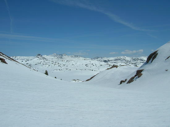
Here's a shot from a ski trip in late April of 2007 – the lowest snowpack in recent years, I think around 50% of normal – in the Emigrant Wilderess, which is north of Yosemite. This is about 9600 feet elevation.
Brown Bear Pass looking South

Oh – and at the end of that week we finished off the trip with a blizzard and whiteout conditions, on May 2nd.

PostedFeb 7, 2012 at 7:49 pm

Thanks for the info, it was exactly what I was looking for. I didn't want to show up in Yosemite with my 3-season gear only to to be trudging through three feet of snow. I think I will stay back east and take on the Tuscarora trail and save the JMT for another year.

PostedFeb 14, 2012 at 3:42 pm

I found this thread because I was looking for the same info. I'm from the East Coast and will be in CA in late april. Wanted to do a several-day hike starting in Seven Pines, going west on Sierra High Route, south on JMT, then through Mt. Whitney downto Whitney Portal trailhead.

My friends and I climbed Mt. Whitney in late April 2009 via the Mountaineers Route, and it was fine. We didn't have skis or even snow shoes, only crampons and ice axes for the last, steep stretch. There was only minor postholing between lower and upper Boyscout lakes, and firm footing everywhere else.

Could anyone please be more specific about the dangers of this hike (which I want to do only if the snow remains at these record-low levels through April).

Thanks!

PostedFeb 14, 2012 at 4:07 pm

And forgot to ask: do you guys know a good source of snow pack data? I found a bunch of info on the NOAA site, but it's hard to make sense of.
Thanks,
RM

PostedFeb 14, 2012 at 4:36 pm

If you've been up the Mountaineer's Route on Whitney, then you likely have the mountaineering skills and gear to deal with what you might find on the HST in late April. However, I wouldn't equate conditions on Whitney with conditions elsewhere in the range. When you climb Whitney from the east side, you're climbing it from the drier side – so less snow usually. So, if you do plan to go, be prepared for more snow than you are thinking you'll see. I would still expect that snowshoes or skis would be faster than postholing, unless we end up with an extremely low snow year. You'd likely want those crampons and axe along for the passes. And kep in mind that sizable storms can and do happen in late april, so be prepared to get a foot or two of snow dropped on you and on the trail.

You also need to have plenty of off-trail experience, so that you can be confident that you can navigate if the trail is completely covered by snow, which it may be even if it is only a couple feet of snow.

The other thing to be aware of, and this is the real danger, is creek crossings. In late April they can be deadly. Deep and fast.

Snowpack info – here is the place: http://cdec.water.ca.gov/snow/current/snow/

both real-time sensors and hand measurements (once monthly) are available. The sensors closest to your route look like Chagoopa Plateau and Upper Tyndall Creek.

PostedFeb 14, 2012 at 4:52 pm

"The other thing to be aware of, and this is the real danger, is creek crossings. In late April they can be deadly. Deep and fast."

+1 You'll need to watch your step crossing Wallace Creek down in Kern Canyon and once you're on the JMT. However, the potentially most problematic of all is Wright Creek where it crosses the HST about half way up to the JMT from Junction Meadow. It flows out of a very narrow slot in the canyon wall on the upstream side and, when running high, can shoot across the trail, making a crossing extremely difficult/dangerous. There is no good option on the downstream side of the trail to avoid this.

Bob Gross BPL Member
PostedFeb 14, 2012 at 4:54 pm

"There is no good option on the downstream side of the trail to avoid this."

Tom, what about upstream?

–B.G.–

PostedFeb 14, 2012 at 5:06 pm

"Tom, what about upstream?"

It's a near vertical wall, Bob. No good options there, either. In early season when the streams are running high, Whitney, Wallace, Tyndall, Wright and the Kern can all be difficult to cross, but at least with all but Wright you have the option of looking up or down stream for better places. That is not the case with Wright Creek going up the HST from Kern Canyon. If you had to retreat, your only options would be to move upstream and take your chances with Tyndall, or head downstream and bushwhack up Whitney Creek out of the Kern Canyon. I've been down that route 3 times, and it is really steep. I wouldn't want to try ascending it, especially when I'd still have to get across the creek just after reaching the rim of the canyon, with the possibility of success unknown.

Kattt BPL Member
PostedFeb 14, 2012 at 5:14 pm

"I wouldn't want to try ascending it"

Tom, what about descending it?

J.K.

Bob Gross BPL Member
PostedFeb 14, 2012 at 5:22 pm

I've made some notations on my electronic topo map about Wright Creek in early season. I would not want to let Wright Creek become the Wrong Creek. Thanks.

I'm always open for suggestions about how to make difficult stream crossings when the water is high. It is not so difficult when you have two or three people, because you can rig up a rope. But when solo, ropes are almost impossible. This is further complicated since I seldom use trekking poles. If there is one place that poles are useful, it is in a stream that is knee-deep or worse. Some of us skinny guys don't carry enough ballast to hold us down in the water.

–B.G.–

PostedFeb 14, 2012 at 7:11 pm

"Tom, what about descending it?"

Eminently doable, Kat. I did it 3 times in the 80's on my way to Colby Lake, Kaweah Basin, and The Upper Kern Basin, respectively, coming in over Crabtree Pass from Horshoe Meadows. I stayed on the south edge of the deep gorge cut by the creek until I came to a long, steep gully that took me down to the creek just below a pretty high waterfall. After crossing the creek I descended to the HST on slightly less steep terrain thru thick manzanita. Don't wear shorts. There is also another gully that I ended up taking on my third trip because I was yakking with a friend and not paying attention to business. It was an even steeper, loose, cr^ppy gully that was a much shorter trip down, but very hard on gear and my butt. I had my thermarest lashed to the bottom of my pack and sliced a hole in it that couldn't be patched. I did not sleep well for the remaining 11 days of that trip. Last time my pad was ever outside my pack. It is a lot of fun if you have strong legs, are comfortable off trail, and can interpret maps reasonably well. Very seldom done, no trace of humans, very wild. I highly recommend it.

Edited: However, if you decided to do it in early season it would probably be wise to take the second gully, the rotten one. If the creek was running too high to cross at the bottom of the first gully, you would have to climb back up the gully, not an easy task. By taking the second gully, you would cross Whitney Creek down in the canyon where it is flowing on a lower gradient with more options for crossing, either up or downstream.

PostedFeb 14, 2012 at 7:14 pm

"Some of us skinny guys don't carry enough ballast to hold us down in the water."

It's sometimes called the unbearable lightness of being Wright. Or is it Wrong? ;=)

PostedFeb 14, 2012 at 7:53 pm

Take it for what it is worth at this stage of our winter, but I have been working a little over 9000' around Tahoe lately, and where there was 16 – 18 feet of snow in Feb. last year, there is only about 16 – 18 inches this year. We are expected to get a storm tomorrow, so all bets are off what it will be like after, but if we don't get a significant quantity of snowfall the rest of the month and into March, I wouldn't completely rule it out. I also wouldn't make any non-reservable reservations or plans either!

Viewing 25 posts - 1 through 25 (of 27 total)
Loading...