Topic
5-day route in Winds in late July this year?
Forum Posting
A Membership is required to post in the forums. Login or become a member to post in the member forums!
Home › Forums › General Forums › General Lightweight Backpacking Discussion › 5-day route in Winds in late July this year?
- This topic has 25 replies, 6 voices, and was last updated 4 years, 8 months ago by
 John Vance.
-
AuthorPosts
-
Jun 19, 2019 at 5:06 am #3598407
see below
Jun 19, 2019 at 5:06 am #3598408tl;dr Any suggestions on 5-day routes in the Winds that have will have minimal bugs and snow-free passes in late July, and a consistent variety of scenery?
I have a rare opportunity to do a 5-day solo backpacking trip; therefore, I plan on heading to the Winds. This trip will be in late July, and yes, I realize that is probably peak mosquito season and that they will completely destroy me and forever ruin my love for the outdoors, but that’s my only chance this year so that’s when I’m going.
My only previous trip to the Winds was in the Elkhart/Titcomb area. I was thinking this time I’ll probably try a different area. The Cirque of Towers would be nice to see, but a number of other places have also caught my eye (from browsing the Pallister book) such as Bonneville Basin, East Fork/Desolation Valley, Baptiste Lake, Deep Lake, Lizard Head Plateau, New Fork Plateau. I don’t need total solitude, although I want to be able to easily find campsites. I’d really love to do some relatively easy off-trail travel but nothing exceeding Class 2+ or so. I tend to care more about consistent and varied scenery than I do about the best scenery. For example, I actually preferred Indian Basin over Titcomb Basin because it had more variety in the views; even though Titcomb is slightly more spectacular, I felt like the views walking down Titcomb basin were basically the same most of the way in, whereas the trail in Indian Basin would wind around and have more varied scenery.
Anyway, here are my questions:
1. Snow conditions: Will most of the passes be pretty much snow-free by late July this year? I haven’t planned a specific route yet, but some of the passes I am considering include Texas Pass, Illinois Pass, Jackass Pass, Raid/Bonneville Col (“Pain-in-the-Ass Pass”), Middle Fork Pass, Hailey Pass, and Macon Lake Pass (obviously not all of these). If any of these will likely still be difficult due to lingering snow, please let me know. I won’t have an ice axe or crampons, and would much prefer to leave the microspikes at home if possible.
2. Bugs: Any tips on how to avoid them? Any suggestions on routes and campsites that will have fewer bugs? Campsites up higher away from water would be great, especially if they have a little breeze to help with the mosquitoes, but I also would prefer to not be totally exposed to the full wind. I will plan on wearing long sleeves/pants (soaked in permethrin) and will bring a headnet; any other tips to mitigate the mosquitoes would also be greatly appreciated.
Jun 19, 2019 at 3:05 pm #3598433Lots of options for 5 day routes – Caltopo.com and Google Earth are good tools for basic location and trail research. You’re right about peak mosquito season – plan on good clothing barriers and camp as high as is prudent given the weather, your gear and your experience level.
Snow levels are quite high this year as show here:
https://www.wcc.nrcs.usda.gov/ftpref/data/water/wcs/gis/maps/west_swepctnormal_update.pdf
Here are some prior BPL threads on this topic you may find helpful:
https://backpackinglight.com/forums/topic/5-nights-in-the-wind-river-range-trail-suggestions/
Jun 19, 2019 at 3:16 pm #3598435Thanks Lester. I agree that Caltopo and Google Earth are great tools. What I am not as good with is predicting the snow conditions up there, so thanks for the link. I don’t know Wyoming very well—would the Southern Winds be roughly the area marked 152% on that map?
Jun 19, 2019 at 3:32 pm #3598438“152” % of median – at 150%+ of normal.
Here is a more detailed map of WY:
Jun 19, 2019 at 10:20 pm #3598484You can also look at the CDT graph posted on Postholer Postholer CDT Snow Graph
If you correlate that graph with their trail Data Table here: Postholer CDT Trail Data Table
It appears that the heavy snow in the Winds this year runs from the south up to @ MP 1850 which correlates with Bonneville/Raid Lake/ Pain in the @ss Pass etc. and is actually maybe low north of that.
At that end one tactic might be to pick passes that aren’t so steep on the north side like the pass above or possibly Macon. Illinois and Texas look steep on both sides. I’ve seen Texas but not crossed it. Not seen Illinois or Macon. Seen the north side of P.I.T.A.
Jun 19, 2019 at 11:26 pm #3598487PITA is one of my favorite passes. Especially if you cross high and descend or ascend just south of the lake. It is steep, slick, and exhilarating with fantastic views. Texas is the easiest pass of those mentioned and the scenery either direction is world class.
Jun 20, 2019 at 4:33 am #3598511Thanks everyone. I’ll take this all into account as I look over the map in more detail over the next couple of weeks and plan some possible routes!
Jun 20, 2019 at 12:27 pm #3598544Ryan – Here is one I did a few years ago that you might be interested in. It is a combo of on trail and off trail, and goes to a couple of areas you mention, Bonneville Basin and Cirque of the Towers.
Jun 20, 2019 at 5:56 pm #3598593That’s a great route. I would just change two things assuming a clockwise route. When you come over the pass between middle fork and Bonneville, just head up the pass at the south end of the upper Bonneville lake passing the lake on the west side, as the right side is heinous to say the least. This is the PITA pass referenced earlier. This year’s snow may make it too sketchy and in cooler weather it can be iced up, but I really like it and it’s faster. Also, no need to drop down south of pyramid lake only to hike back up, just head up the pass east of the lake and drop down on the Haley pass.
Jun 20, 2019 at 8:19 pm #3598613Brad thanks for posting that route.Nice to see it on Caltopo and get some basic lines verified Anything special or noteworthy regarding Macon? Was Illinois all that and more? (dicey – loose – really difficult)
John Vance you answered 2 questions I’ve been wondering for awhile. Verification about the route to Raid – Bonneville Col from the outlet dam of Bonneville Lake AND the “shortcut” around the north side of Pyramid Lake up to the corner of Pyramid and over to Hailey Pass. That looks like a good route if you’re going to or from the east side of Hailey to the upper East Fork. Thanks for that verification. Yes and the climb up to Bonneville Lake from 10521 seemed harder than the Pass over to Donna!
BTW the hike into 10521/Bonneville from Scab Creek is not that hard at all and gives one another point to start/end a loop.The “trail” from Raid /CDT is easy and obvious and Scab Creek TH Is a lot closer to Pinedale than Big Sandy.
Jul 1, 2019 at 2:44 am #3600123Thanks again all. Brad—that route looks great but probably a bit long for me on this 5-day trip. John—that shortcut up to the corner of Pyramid and over to Hailey Pass sounds nice, but I’m worried there might be snow/ice on the North side in late July this year?
Also, I have two other related questions (if people don’t notice these questions here, I may start a new post):
- By all accounts, the bugs are typically awful in the Winds in late July. Do they tend to go away at night? I would love to bring my pyramid tarp/bivy, but if bugs are swarming right on my bivy at night an inch from my face, I know they would keep me awake. The only times I have ever backpacked with lots of mosquites in the past, they have disappeared after dark, and I was either fine with my tarp/bivy or wished I had brought it instead of the tent. But if in doubt I’ll just bring the full 4-lb double-wall tent.
- I am thinking of doing the Texas Pass loop (Big Sandy TH to Shadow Lake to Texas Pass to Cirque to Deep/Temple Lakes to Big Sandy TH), and I am trying to prepare for the snow on Texas Pass (this will be in late July). I bought an ice axe and practiced self arrest/belay last week, and will head out this week for a 2nd practice session.
- I was hoping that microspikes (on trail runners) and an ice axe would be sufficient for Texas Pass. Does that sound reasonable? Should I bring crampons instead?
- I’m assuming that ascending the North side of Texas Pass would be easier than descending it? (the North side is steeper and holds more snow, so I would rather ascend it, but on the other hand, the snow will have softened up somewhat if I descend it, as it will be later in the morning).
- On that note, what time of day do you think would be ideal to attempt that pass? I was thinking 8-9am or so, and I can wait a little longer if needed for it to soften up a bit?
Jul 1, 2019 at 3:04 am #3600125This year could be very different from the typical year. I haven’t seen any reports for high passes yet in the winds, but on the 21st of June some of the high meadows (10k or so) had 2 feet of snow. Snow will make some passes easier and others more difficult. Depending on cornices at the last bit of the pass, it could be a bit nerve wracking.
Asking here and on others sites will be the best way to get intel as well as the journal hosting sites, although with all the flip flopping going on this year on the CDT, there may not be much at this point. In a couple weeks it may different, both in terms of intel and pass conditions.
Jul 1, 2019 at 2:31 pm #3600160Ryan,
I’m not much help here. Though I’ve been to the Winds four times, they have all been in late August or early September and I’m not sure I’ve seen a single mosquito. I too hear they can be bad (really bad) in July. I have a trip to the Sierra in early August and am preparing for the worst.
As you already know, the north side of Texas pass is a steep scree slope. I’ve done it twice with no snow, though both times there has been a small snow field on the south side. It sounds like you are going things about this the right way, but I don’t have any better knowledge for you.
I imagine someone will have already crossed Texas pass as it sees quite a bit of use for a so called “off trail” pass. In fact, it felt like there was a spider web of trails on the north side.
Jul 18, 2019 at 4:26 pm #3602476Just came out of the western Winds, Jim Creek to Irish Canyon. Snow is still lingering, but melting FAST. Anything below 11k shouldn’t have much of anything left. Bugs were the worst I’ve seen in a few summers, but manageable with standard precautions. Fishing is really picking up, after a cold, snowy start to the summer. Snow has gone isothermal even up high, and nights were above freezing by a good margin. Kicking steps was fine in trail runners.
Jul 22, 2019 at 6:51 am #3602934Ok, now I think I’m changing my plans at the last minute. My new tentative route is as follows:
Day 1: big Sandy trailhead to desolation valley (East fork)w
Day 2:. Over Hailey pass to Baptiste lake
Day 3: over Macon lake pass to washakie lake
Day 4: to Valentine lake, then South fork lakes, then ascend to lizard head trail, then camp at bear lakes
Day 5:. Return via jackass pass
two last-minute questions:
1. Is the road to big Sandy trailhead currently doable in a minivan? In an outback? (I would prefer to take the minivan if possible)
2. Would you recommend bringing an ice axe for this route? Microspikes?
Thanks again all!
Jul 22, 2019 at 12:44 pm #3602942The road to Big Sandy can be in various states of repair, but you should be fine in a mini-van. I’ve done it twice in compact rental cars and had no issues.
I can’t attest to the conditions right now, but I have done all the passes you have listed and none held any snow when I was there.
That sounds like a really good route. Desolation Valley is a really nice walk if you go up the valley toward Bonneville Raid Col. You can stay up high around 10,700 feet and it’s wonderful walking all the way to the talus field that goes up the Col.
Jul 22, 2019 at 8:05 pm #3603012I hope you’ll post something; even just a quick recap of your experience or even pm me about what you encounter. I’m considering a similar route late August.
Snow lingers the longest on northeast exposures which make perfect sense when you think about it. Macon has a southern exposure. Your exit from South Fork to the Lizard Head Plateau I’m guessing is from Lake 10,500 and will be one of those gullies. They both face pretty much dead west and are open to lots of light. The south gully especially.
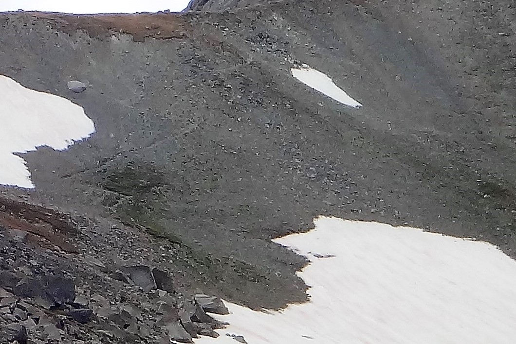
You may have to work around snow patches on the east side of Hailey. Below is a photo from @ August 15th 2017 which evidently was the big snow year but this year in that part of the Winds seems comparable.You can see the trail switch-backing up the last steep stretch. You should be able to work around BUT if the entire steep upper east side slope holds snow you may wish you had something like some Vargo cleats.Still I’m guessing you won’t be the first over that pass. The lower field can be walked without traction with care and cutting traverses.
Happy Trails!

PS: I guess that short-cut John Vance described is off frame and above the level pass to the right so kind of above that small snow-patch right of the trail/switchbacks. I’ve got another photo with a good angle of that from the trail by the upper twin lake on the west side and it certainly looks doable. Pm me if you’re curious or if anyone else is I could post it here.
Jul 30, 2019 at 4:13 am #3604047Thanks again all. I just did the route as outlined above and it was absolutely fantastic. I brought an ice axe but felt silly because it wasn’t needed. There was some snow on the North side of Hailey Pass which was easily avoided. I took the shortcut over the Pyramid saddle to Hailey Pass and it was easier than I anticipated, and totally dry. The bugs were annoying but not as horrendous as I anticipated (I came prepared). There were no sketchy stream crossings.
obx hiker—let me know if you have any other questions about the route or conditions.
All—if you have any suggestions for similar routes (routes featuring combination of easy off-trail and on-trail sections, hitting as many spectacular basins as possible), please let me know. I honestly liked 4-5 other areas along that route at least as much as the Cirque, and now I’m dying to get back to the Winds to do something similar in the future!
Jul 30, 2019 at 10:17 am #3604063Fantastic! Trip report/photo’s sometime in the future?
Jul 30, 2019 at 3:24 pm #3604102Glad you enjoyed it! The Winds are absolutely fantastic. I am heading up for the last week of August and the first week of September. Don’t know where yet but I often don’t decide until I am halfway there. With 12 days of food my Ohm will be bursting at the seams.
Jul 31, 2019 at 4:54 pm #3604321Congratulations on a nice trip Ryan! Any notes about that “John Vance” short-cut from the Pyramid saddle. I’m guessing once you get there it’s pretty obvious or you don’t have to be all that precise?
Does the snip below show the basic route from Grave over to Macon? I guess you cross Baptiste Creek near where it enters Grave Lake?
Jul 31, 2019 at 6:21 pm #3604337That’s probably the right way to do it. I followed the contour line around and didn’t drop all the way to Grave Lake but crossing the creek there was a field of apartment size talus and then willows – I wouldn’t recommend it. We walked the ridge up to Macon Lake Pass just to the left of the line you have. It was a little steep near the end but was pretty mellow overall.
Jul 31, 2019 at 11:10 pm #3604378John—how in the world do you fit 12 days of food into an Ohm? I wanted to bring my new Ohm but 5 days of food was too much for me (since I also had my full old double-wall tent instead of my tarp shelter, and an ice axe, and…) Guess I need to learn more from this website!
obx hiker—yeah, some line somewhat like that should work. I got a little closer to Grave Lake at the beginning, and ended up exploring the Chain Lake area before climbing the pass, but otherwise followed a similar line. The climb up to Rabbit Ears Lake was easier than I expected; you basically just head up the hill through grass and granite slabs. There was a faint trail (game trail?) much of the way. Perhaps I got lucky and stumbled on the easy way, but I basically just headed S/SW from the W corner of Grave Lake, like you show there, and the hill wasn’t hard at all. Finding a way up the North side of Macon Lake Pass was also straightforward. On the way down on the S side, I think it’s best to keep West and head down to the West side of Macon Lake below. That pass is not too hard overall, but do give yourself enough time to get it done before the afternoon storms come.
The shortcut over the Pyramid saddle was easier than I anticipated. I wasn’t planning on attempting it, but once I saw it (I saw it as I was approaching from the West up high coming from the East Fork basin), I thought it looked pretty do-able and went for it. Both sides were pretty easy to figure out, and snow wasn’t an issue at all. Honestly, descending the North side of Hailey Pass (on the “trail”) was more challenging and dangerous. There, you could choose between snow vs steep scree. Neither was terrible, but both were more sketchy IMO than the saddle over Pyramid (although that was more physically exhausting).
Two more notes: 1. If you do a similar route, make sure to visit Baptiste Lake. It’ll take a little time (the trail kind of disappears as you climb up to it), but it was my favorite part of the entire trip. A true gem. 2. If you go from South Fork Lakes to Lizard Head Plateau like I did, I would recommend camping at South Fork Lakes so you can get an early start on the climb up to the Lizard Head trail. I made the mistake of camping at Washakie Lake instead, and didn’t get up to the Lizard Head plateau until after noon, by which time I was stuck in rain (but luckily no thunderstorms). I highly recommend the route, but that climb was definitely the toughest of the trip (the area is outstanding though).
If you have any other passes or off-trail routes in mind, you’ll have to let me know. I have had mixed feelings about off-trail travel in the past—I love figuring out the navigation and getting away from the crowds, but I hate boulder hopping and fields of talus and the like—but most of those off-trail sections that I hit in the Southern Winds were heaven on Earth. Nice, relatively easy meadows and grassy/granite slopes, with absolutely no people and spectacular scenery. I need to start compiling a list of passes and segments that are relatively easy in terms of the terrain, so I can put together another route like this!
Aug 1, 2019 at 5:02 pm #3604474” I need to start compiling a list of passes and segments that are relatively easy in terms of the terrain, so I can put together another route like this!”
Or as someone put it so well in a post a while back on another thread; ” Get Pallister’s book and study it like a monk”
And flesh out the details in threads like this one. Thanks to all!
-
AuthorPosts

- You must be logged in to reply to this topic.
Forum Posting
A Membership is required to post in the forums. Login or become a member to post in the member forums!
Our Community Posts are Moderated
Backpacking Light community posts are moderated and here to foster helpful and positive discussions about lightweight backpacking. Please be mindful of our values and boundaries and review our Community Guidelines prior to posting.
Get the Newsletter
Gear Research & Discovery Tools
- Browse our curated Gear Shop
- See the latest Gear Deals and Sales
- Our Recommendations
- Search for Gear on Sale with the Gear Finder
- Used Gear Swap
- Member Gear Reviews and BPL Gear Review Articles
- Browse by Gear Type or Brand.
