Topic
Afternoon walk on FS Road #26, Suiattle River Road
Forum Posting
A Membership is required to post in the forums. Login or become a member to post in the member forums!
Home › Forums › Campfire › Member Trip Reports › Afternoon walk on FS Road #26, Suiattle River Road
- This topic is empty.
-
AuthorPosts
-
May 3, 2011 at 9:21 pm #1273282
I went looking for a low level walk and found some trip reports on the Suiattle Rived Road near Glacier Peak, the North Cascades and the town of Darrington.
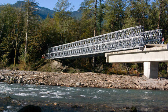
The road was damaged by erosion several years ago and has been closed to vehicle traffic, but is open to foot traffic. It is a great place to walk a dog and I had the road to myself on this weekday afternoon. Is possible to access the trails up river from the road closure, there is just the long approach hike up the road 10+ miles to the trailhead. It looks like the road will be repaired some time this year.
See http://www.wta.org/trail-news/go-hiking/hikes/suiattle-river for more information.
There was a little rain, but not bad. My Aussie had a ball running back and forth. I got in 6 miles and he easily doubled that. It was easy hiking down the road with no traffic to worry about. The views were good in spite of the rain and clouds.
Toby, my Aussie Shepherd
Glacier Peak is up there somewhere….
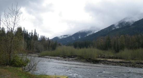
Down river towards Darrington and the highway
May 3, 2011 at 9:28 pm #1732706Nice. It's always good to go out with good company.
May 3, 2011 at 9:47 pm #1732709I forgot to mention that he swiped half my peanut butter and jam sandwich when I wasn't looking. BAD DOG!!!
He was relatively clean at that point– we were on the way up. Toby is really tall for an Aussie and he loves to run– I've never seen a dog that takes such joy in running. That means a lot of mud flung around too. He's really conked out tonight :)
May 4, 2011 at 5:02 pm #1733043AnonymousInactive"there is just the long approach hike up the road 10+ miles to the trailhead. It looks like the road will be repaired some time this year."
I'll bet a lot of the trails upstream are in terrible shape after 5 years of closure. I have a couple of friends who are going up the Sulphur Mtn trail to do the Bath Lakes High Route, and I told them to bring a saw. There'll be blowdown galore. As it stands, the 10+ mile hike from the closure point is adding 2 days to their trip. It's really too bad they haven't gotten around to repairing that road sooner; it has made it really difficult to get into some of the best backpacking in the Central Cascades.
May 4, 2011 at 6:53 pm #1733088There were some Forest Service personnel working in the area. I mentioned to one that it would have made an interesting study to do a before and after on the wildlife population, migration, movement across the roads, etc, had it been known there would be a closure for that long a period.
The roads and trails are all hurting from lack of funds. Once we stop spending billions on extra defense expenditures, we might have a little left over to fix a few roads and trails. I'll bet a few days worth of defense spending would fix all the forest service roads and trails and then some. It's not all about hikers either— those little mountain towns like Darrington really get an economic boost from all the outdoor activities. I'd love to retire and have a little supply store in a place like that! Burgers and Boots!
May 4, 2011 at 7:22 pm #1733108AnonymousInactive"The roads and trails are all hurting from lack of funds. Once we stop spending billions on extra defense expenditures, we might have a little left over to fix a few roads and trails. I'll bet a few days worth of defense spending would fix all the forest service roads and trails and then some."
Somehow it always seems to come down to that. Sad. But then, if we didn't spend all those billions on F-35's, super duper attack subs, littoral combat ships, etc, how would we keep the Taliban from invading the homeland, imposing Shari'a law on us, and mutilating our women?
May 5, 2011 at 1:37 pm #1733436A bike and said 10 miles will go by in an hour, even faster on the way back. Garage sale $50. Beats the tar out of walking!
The bridge to Milk Creek is gone and last time said trail was nearly gone when I was on it as it was. Wonder if the downey creek bridge will EVER be fixed. Doubt it.
You need more than a hand saw up there. Chainsaw or forget it. 4 foot trees with a hand saw, ug. Downey Creek was detreed a couple years ago.
PS. There should be an exception in every wilderness for chainsaws so we stop wasting money sending folks in with handsaws when they can get 10x more work done with a chainsaw.
May 5, 2011 at 5:05 pm #1733510I thought the road would make a great mountain bike trip and you're right, it would go by quickly.
Depends on the handsaw. They took down a lot of timber with "misery whip" 2-man saws. If they can drive the road with a truck, I can't imagine not using a chainsaw.
May 9, 2011 at 5:04 pm #1734705AnonymousInactive"Wonder if the downey creek bridge will EVER be fixed. Doubt it."
They're apparently working on it this summer/fall. It's scheduled for completion by November according to the list of damaged trails/projects at REI. In the meantime, for all you bikers, there is a solod temporary footbridge over Downey Creek that you can use now.
You need more than a hand saw up there. Chainsaw or forget it. 4 foot trees with a hand saw, ug."
I wasn't thinking about the big ones, Brian. I'm not quite that dumb. Close, but not quite. ;) Rather, I was thinking about all the little ones that are so annoying to get around/over/under. A hand pruning saw with a rip tooth blade makes short work of them and can save a lot of aggravation. The big ones are not as frequent, IME, and you just have to take your lumps there. Unless you want to lug a chainsaw. Even then it would take a while to get through some of the really big ones. Not exactly how I'd want to spend a backpacking trip.
I have a friend who's going to do a recon trip up the Sulphur Mountain Trail in June in preparation for the Bath Lakes High Route. I'll post what he finds when I debrief him. I'm expecting a real mess after 5+ years with no trail maintenance, and it'll probably be pretty much the same everywhere in there, so his experience may be predictive.
Jun 11, 2011 at 10:42 am #1747878Brian Austin is right, it's an easy, flat pleasant 10-mile bike ride, even with a backpack. 1-1.5 hours will see you to the old trailhead. The blowdown recently got cleared out because of some rescue effort way up miners creek way. I think there were horses up the road and horses don't "do" blowdown very weill
It's a very low valley, and snow-free most of the year, so it's a good early or late-season walk.
And it ain't going to be fixed this year–there was a lawsuit.
Use a bike. Or walk. Adapt. Enjoy.
These chicken littles who talk about how the glacier peak area is lost and closed off really crack me up. Do you want a road up the twenty-mile Hoh valley trail as well so you can climb Mt Olympus in a day, and save yourself all that tiresome hiking?
Jun 12, 2011 at 8:31 am #1748141If they are going to close the road, then it should be done. I'm all for having mountain bike access an hybrid hiking options like that. You could ride the Suiattle River road with a very basic bike.
They closed the Taylor River road years ago and I think that has gone well. The Monte Cristo road has pretty much closed itself and there are all kinds of people out walking it. I saw a couple church groups up there last summer with small kids and grandparents included. That one does need a safe foot bridge over the river.
On the other hand, you don't want to close off hiking access too much. I think there will be a loss of hiking culture and my fear is that people won't know about hiking and enjoying the wilderness, with a loss of funding and more ignorance about the natural world. The more accessible areas get tramped pretty hard too. These are hard questions and maintaining a balance is difficult.
We have long transitioned from islands of "civilization" in a sea of wilderness to islands of wilderness in a sea of developed land. We need to budget and plan to make the most of the natural areas left. No decision is a decision too.
Jun 12, 2011 at 3:52 pm #1748270AnonymousInactive"The blowdown recently got cleared out because of some rescue effort way up miners creek way."
Are you referring to the road, Suiattle River trail, both, other?
"And it ain't going to be fixed this year–there was a lawsuit."
Who sued who? Over what?
Jun 12, 2011 at 5:58 pm #1748323The North Cascades Conservation Council sued to stop repairs on the road because they hold that the Forest Service stepped outside the law and didn't do the proper environmental impact workup.
http://americanalps.blogspot.com/2011/06/suiattle-river-road-real-story.html
My take is there are a lot of "before and after" issues with access roads. Many of the roads are decades old and when they get damaged, the repairs need to follow the newer regulations. The Boundary Bridge that crossed the Suiattle River to FS #26, just below the current Suiattle River (FS #25) road closure. The far approach was washed away and newer regs for stream and rivers made repairs or replacement difficult as supports can't be put in the stream bed. The solution was to put a new bridge section on the old one and build a ramp to access it. Ugly, but functional:
I was talking with a ranger while hiking Friday and we were admiring the hard work done by a volunteer trail crew the previous weekend. They cleared a very popular trail (Barclay Lake) of some large blowdowns with a chainsaw. The ranger mention that similar work in the adjacent designated wilderness areas had to be done with hand tools– no power saws allowed. I'm grateful for the young folk who do backbreaking work like that to keep the trails in shape. I think the regs are interesting to note. I wouldn't want to carry a chainsaw with a 4 foot bar very far up a steep trail!
Thanks to the Unknown Trail Crew!
Jun 12, 2011 at 6:22 pm #1748333AnonymousInactiveThanks for the update, Dale. Interesting times. If that lawsuit wins, some of the areas accessed will become true wilderness in a short time. Dome Peak, Buckindy Snowking Traverse, Bath Lakes High Route, Lime Ridge, to name a few. Probably not a bad idea, as it will probably weed out all but the truly determined.
Jun 12, 2011 at 7:48 pm #1748394The whole road closure thing would have been interesting for a "before and after" study of wildlife in the area. Some graduate student could have done some nice work. Of course no one thought it would be closed this long.
I wonder what one day's expenses in Afghanistan and Iraq would do for wilderness projects? It sounds like a single-interest issue, but having those recreation opportunities means a lot of business for the small mountain towns, river rafting oufitters and fishing guides, not to mention the equipment industry. There are educational and health benefits as well. Think of all the businesses that revolve around the Appalachian Trail.
-
AuthorPosts
- You must be logged in to reply to this topic.
Forum Posting
A Membership is required to post in the forums. Login or become a member to post in the member forums!
Our Community Posts are Moderated
Backpacking Light community posts are moderated and here to foster helpful and positive discussions about lightweight backpacking. Please be mindful of our values and boundaries and review our Community Guidelines prior to posting.
Get the Newsletter
Gear Research & Discovery Tools
- Browse our curated Gear Shop
- See the latest Gear Deals and Sales
- Our Recommendations
- Search for Gear on Sale with the Gear Finder
- Used Gear Swap
- Member Gear Reviews and BPL Gear Review Articles
- Browse by Gear Type or Brand.