Topic

Smokies AT Traverse


Forum Posting

A Membership is required to post in the forums. Login or become a member to post in the member forums!

Home Forums Campfire Member Trip Reports Smokies AT Traverse

  • This topic is empty.
Viewing 23 posts - 1 through 23 (of 23 total)
  • Author
    Posts
  • #1262564
    Trevor Wilson
    BPL Member

    @trevor83

    Locale: ATL -- Zurich -- SF Bay Area

    I had really been wanting to hike the AT through Great Smokey Mountain National Park for quite a while. Finally I was able to take two days off of work earlier this month to give me 4 days to complete the hike from 8/12 – 8/15. I started at Fontana Lake with a base weight of 7 lbs (excluding DSLR camera gear carried around my neck in a holster) and a total pack weight of 12 lbs with 1.5 liters of water and 2 days of food (I would resupply at Newfound Gap where I met up with my wife).

    Some quick AT stats for the hike:
    Distance: 71 miles
    Total Elevation Gain: 18,660' (12,800' in first 40 miles and 5860' in last 30 miles)

    Day 1: Fontana Dam to Spence Field Shelter – 16.4 miles

    My day started early as I had to drive from Atlanta to Big Creek Ranger Station and then catch a 2 hour shuttle down to the start of the AT in the park at Fontana Lake. I received my shuttle ride from Ronnie McGaha (865-322-2752). Ronnie is part of the 900 mile club meaning he's hiked all 900+ miles of trails through GSMNP. I picked his brain for advice on the park for most of my 2 hour ride and would highly recommend him for shuttle services if you are in the area.

    I hit the trail right at 11:00 AM and began the 2000' ascent from the Fontana Lake up to Shuckstack with the hopes that I'd get some great views. About 2 miles into the hike, I saw my first of three bears for the day as he bounded off the trail about 20 yards in front of me.

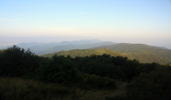
    I reached Shuckstack drenched with sweat and climbed the fire tower in hopes of great views. My stay at the top of the fire tower was cut short as I hustled down off the old rickety fire tower after noticing an impending rain storm coming straight at me from off of Gregory's Bald.

    View from Shuckstack:
    shuckstack view

    After leaving Shuckstack, I continued up the trail in light rain and saw two more bears before I reached Birch Spring Gap about mile 6. I wasn't able to get a clear picture of any of them unfortunately. I filled up my water here since I had heard the next water sources were dry until I was to reach my destination at Spence Field Shelter.

    I reached Spence Field without incident and found a very crowded shelter to my dismay. I was hoping on a random Thursday night it might be pretty open but those wishes were not granted. There were 10 in the shelter and another 4 camping there illegally in their tents.

    Disaster struck when I went to grab my spoon and realized I forgot one. I was able to eat my chicken and rice dinner with my fingers that night by rehydrating it with a little less water than usual and stirring in the hot water with a beef jerky package. Thankfully, I encountered some trail magic and someone at the shelter had packed an extra plastic spoon to stir coffee with and gave me that spoon so I could use it for dinner that night!

    Day 2: Spence Field Shelter to Mount Collins Shelter – 20.3 miles

    I woke up in time to take a few pictures of sunrise and get off to an early start.

    Sunrise from side trail to shelter:
    spence field sunrise

    Little did I know there are some great views from Rocky Top just a mile north from Spence Field Shelter. I reached this area just after the sun had crested above the mountains and I had a beautiful Smokies morning mountain view:
    view2

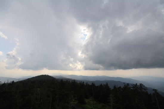
    I stopped in at Derrick Knob Shelter four miles later to fill up with water, air out my feet, and tape up my heels (still a bit tender from blisters worn on my Roan Highlands trip the month before). From Derrick Knob Shelter the trail gains almost 2,000' as it climbs up Siler's Bald and then on to Clingman's Dome. I waited out a hard thundershower in the Siler's Bald Shelter while I ate lunch and then headed north to Clingman's Dome. I had never been to this AT high point at 6,643' so I was hoping to have some nice views from the top.

    Although it lightly rained almost my entire time at on top Clingman's Dome, I actually lucked out with some pretty great views:

    Looking South:
    clingman's 1

    Looking North with Mt. Leconte in view:
    clingman's 2

    After taking in the view and relaxing on top of the Clingman's Dome observation deck, I began to descend off of Clingman's Dome in the rain and I saw a beautiful double rainbow (you can unfortunately only make out one in this picture):
    rainbow

    Because of the rain, the trail became a small creek and my feet and shoes got soaked. My feet would not be dry again while I hiked during the rest of the trip.

    I saw my fourth bear of the trip right off the AT before I turned down the Mt. Collin's Shelter side trail. I arrived in to the shelter about 8:00 PM after a long day of hiking, cooked dinner, and passed out.

    Day 3: Mount Collins Shelter to Tricorner Knob Shelter – 20.6 miles

    I woke up early to make sure I was at Newfound Gap in time to meet Brad Rogers and Megan (my wife) for the second half of my hike. I had enjoyed my two days of solo hiking but was looking forward to the good company for the remainder of the trip.

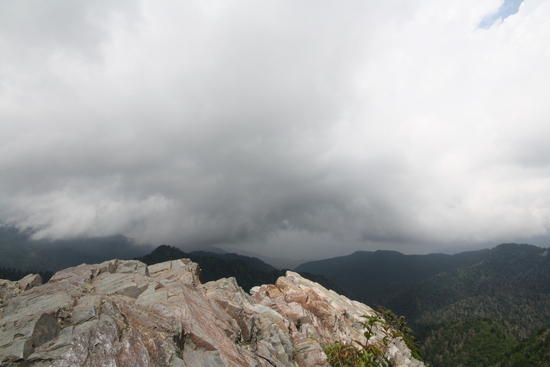
    Brad and Megan were right on time and we were back on the trail by 11:00. We headed north with aims to stop at Charlie's Bunion for great views and lunch. We stopped for lunch but it was a pretty cloudy day. These were unfortunately the best views of the day as we didn't have any visibility from the Sawteeth or or Bradley's View.

    Picture from Charlie's Bunion:
    charlie's bunion

    After Charlie's Bunion we headed north in intermittent rain. We never ended up in a thunderstorm but it rained throughout much of the afternoon and the trail was a flowing, rocky stream much of the way north to Peck's Corner Shelter. We arrived to find a very crowded shelter full of hikers and an AT trail crew that had been drenched in thunderstorms. I always enjoy talking with the trail crews. There was also an ATC Trail Runner staying at the shelter who had a way of interjecting in every conversation going on. Brad and I had doubts about his authenticity – he didn't wear a uniform or have a communication device and was quite overweight which didn't seem to indicate someone who hikes over 20 days a month covering many miles each day across the AT. In the end we concluded he was most likely legit but it was definitely suspect.

    Day 4: Tricorner Knob Shelter to Big Creek Ranger Station – 17 miles (including side trip to Mt. Cammerer)

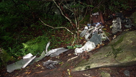
    Luckily the weather for my 4th and final day turned out quite nice and there was a lot of sunshine after the morning clouds were burnt off by the afternoon sun. As in Jamie Short's well written BPL article, we came across remnants of the F-4 Phantom fighter that had crashed in 1984 just past the Snake Den Ridge Trail:
    f4 figher

    We ate a snack and filled up with some ice cold water at Cosby Knob Shelter. From there we continued on to Mt. Cammerer to enjoy some of the best views the Smokies have to offer:
    mt cammerer view

    Mt. Cammerer Fire Tower
    mt cammerer fire tower

    From there it was about 5 miles and a 3,000' descent to Big Creek Ranger Station.

    My biggest lessons learned and take aways from the hike were:
    1. I really enjoy hiking all day long and taking in as much of the trail as possible. I much prefer this to rolling into camp early and sitting around at a shelter for a few hours before bedtime.
    2. Don't forget an eating utensil – eating really hot and watery food with fingers is not as fun.
    3. Trench foot is painful. I'm going to try Hydropel as Brad recommended on my next Summer hike or hike where significant rain is expected.
    4. Umbrella's are awesome rain gear in the hot and muggy Southeast Summers.

    Overall it was a great trip and I was happy to have the opportunity to hike the AT through the park. It would have been great to have better weather on Day 3 as the Section from Icewater Spring Shelter through the Sawteeth is an awesome section of trail. My legs felt much better on this this hike than my comparable hike in the Roan Highlands the month before. That hike along with my runs the previous month definitely increased my stamina and leg strength to help make this a more enjoyable hike.

    Edited for spelling and punctuation.

    #1639959
    Eddy Walker
    Member

    @ewker

    Locale: southeast

    thanks for the trip report and pictures. Bummer about the rain but considering how hot and dry it has been I am sure it was needed. I do need to get back up to the Smokies for a hike

    #1639996
    Trevor Wilson
    BPL Member

    @trevor83

    Locale: ATL -- Zurich -- SF Bay Area

    Thanks Eddy! The rain definitely cooled it down a bit which was nice. I was more disappointed about the clouds hiding the good views than the rain. We were pretty lucky with rain considering I think there were thunderstorms all around us that never hit us directly.

    #1640012
    Patrick S
    Member

    @xpatrickxad

    Locale: Upper East TN

    Looks like a good trip. We definitely needed the rain, but its a bummer it affected your trip. But hey it HAS to rain otherwise its not the Smokies! right? Too bad it was cloudy on that stretch near Charlie's Bunyon thats one of my favorites, but then again every time I've been on Cammerer its been raining or snowing.

    There is something special about hiking in the rain though. I love it when the trail turns to a creek. And you never have to worry about how dry the springs might be.

    #1640013
    Brad Rogers
    BPL Member

    @mocs123

    Locale: Southeast Tennessee

    I enjoyed hiking with you again and meeting your wife for the first time. Great trip report and pics, thanks for sharing.

    #1640027
    Trevor Wilson
    BPL Member

    @trevor83

    Locale: ATL -- Zurich -- SF Bay Area

    You bet Brad. Always a pleasure! I'm glad it worked out we could do another trip again before we (hopefully) move in September. Thanks for organizing the trip!

    #1640167
    Jamie Shortt
    BPL Member

    @jshortt

    Locale: North Carolina

    Trevor, Fantastic trip report! Thanks for the mention. I really appreciate the little details that help someone try to take on the same trip…for example reporting the name and number of the person who helped provided the shuttle. I've been thinking about doing this exact trip, but wasn't sure how to get from one end to the other.

    I might have missed it but was wondering how easy it is to find water when following the AT through this section as it stays high in elev? I've always looped back down where water is easy to find.

    Glad you could hook up with Brad. His work to bring together ultralight hikers in the SE is to be applauded. I hope to soon have some free time that intersects with his many trips.

    Many thanks!

    Hike on,
    Jamie

    #1640171
    Brad Rogers
    BPL Member

    @mocs123

    Locale: Southeast Tennessee

    Water isn't too hard to find. There are good springs at all of the shelters, which are spaced at ~5-6 mile intervals. If you are going in late summer or early fall, you might check the NPS website to make sure some aren't dry. They normally update the site every few days. (scroll to the bottom for water/bear updates)

    Shuttles that I have used in the area are:

    Standing Bear Hostel (Curtis and Maria) 423-487-0014 (north end of the park)

    The Hike Inn (Jeff and Nancy) 828-479-3677 (south end of the park)

    Trevor used a different shuttle driver and seemed pleased with the experience.

    #1640212
    Trevor Wilson
    BPL Member

    @trevor83

    Locale: ATL -- Zurich -- SF Bay Area

    Thanks Jamie. Great to hear you enjoyed the trip report!

    For shuttle transportation, I had quoted two shuttles and just chose the slightly cheaper option. I have heard good things about both the Standing Bear Hostel and Ronnie and don't think you could go wrong either way. It's good to know there are a couple options though in case one is already booked up.

    Even though this is one of the toughest times of year for water, I think the longest stretch without water was maybe 8 miles on the first day as the spring at Mollie's Ridge Shelter was completely dry. It was the only piped spring that was dry for the entire trip that I came across. There were two that were just a trickle and a couple where it was no longer flowing through the pipe but still seeping up into a crystal clear pool to bail water out of.

    Let me know if you have any other specific questions – I'd be happy to help out in any way.

    #1640256
    Robert Carver
    BPL Member

    @rcarver

    Locale: Southeast TN

    Glad you had a good time on your hike. The trail through the park is very nice. I find the Newfound Gap to Davenport Gap section a little easier. I was at Peck's corner the night that you were at Tricorner. Looks like you met Caleb who is the lone ridgerunner for the rest of the year. Yeah, he is a bit talkative. Nice guy though.

    #1640339
    Tom Clark
    BPL Member

    @tomclark

    Locale: East Coast

    Trevor,
    Nice report, thanks for sharing.

    Interesting comments about the umbrella. I can certainly see some advantages of an umbrella in the summer, but have always wondered about the balance of narrow trails with overhanging branches that might snag the umbrella. I also wondered about the ability to get good coverage when the wind was blowing and you'd end up needing (wanting) both umbrella and rain coat. Any thoughts?

    Tom

    #1640355
    Trevor Wilson
    BPL Member

    @trevor83

    Locale: ATL -- Zurich -- SF Bay Area

    Thanks Robert and Tom.

    Robert – what time did you get into Peck's Corner? We almost made the side trip down there to fill up on water probably around 4 or 4:30 but we decided we didn't need the refill in the end. I hope you had a great trip!

    Tom – re umbrellas. I've taken an umbrella on quite a few hikes and this was really the first opportunity I had to use it for more than a couple minutes. Overhanging branches are certainly something to navigate around but I found it not to be too much of an issue. Since we were on the AT, it was never completely overgrown. If you were on a very overgrown trail I could see branches and really tall grasses being somewhat of a problem.

    The umbrella really excels where it is either very humid and you would get drenched from sweat if you put on a rain coat or when it is very sunny (from what I hear as I have not used an umbrella for this application). In the wind, you definitely catch a few rain drops but overall I was much more comfortable with some of the rain spray than I would have been overheating and sweaty in a rain coat. I also used ULA Rain Wrap for lower body coverage and that combined with the umbrella gave me great coverage that was quite airy. I highly recommend that combo for SE summers.

    As you mentioned about coverage in blowing rain, my primary concern going into the trip with this setup was around warmth when the temps drop a bit and it is blowing rain. For this reason, I actually brought my O2 Rainshield jacket instead of my wind shirt just in case. It weighs 3 ounces more than my Montbell wind shirt but with my limited experience with this set up it made me feel more comfortable. As it turned out, the only time I put on my rain coat during the hike was after we were sitting in the shelters in the evening for warmth. I would think a wind shirt would be adequate warmth for me above 50 degrees or so while hiking in the rain and will most likely take it instead on future SE summer trips. My windshirt + umbrella (birdipal dainty) + rain wrap combo is right about 10 ounces so it's pretty light weight and I consider it pretty versatile.

    #1640363
    Kattt
    BPL Member

    @kattt

    I am impressed. Your base weight seems like an unreachable goal to me. Nice pictures too.

    #1640402
    Trevor Wilson
    BPL Member

    @trevor83

    Locale: ATL -- Zurich -- SF Bay Area

    Thanks Katharina! You can do it! In my experience, it mainly takes some re-evaluation of what you need to be comfortable and then experimenting with it. There are a couple things I've missed on these last two summer hikes(like an extra pair of dry underwear after a hot and humid day) and I will consider adding that back in pack on my next trip. For the most part I haven't really needed anything extra to be or feel comfortable over my last few trips. I would guess Summer in the SE one of the best places to experiment with pushing your comforts due to the relatively low elevation and warm temps. This last Spring and Summer has been a big learning experience for me in terms of weight reduction and comfort though. Before this past Spring the lightest trip I had taken was probably with a 10 lb base weight. After a few lighter weight trips, I felt as though I was brining some nice luxuries on this last trip with my 7lb base weight – inflatable pillow, air mattress instead of foam, umbrella and rain jacket, etc.

    It has all been a really fun learning experience though so far and I look forward to continuing to refine my style and kit. Last year, I never could have hiked 70+ miles in 4 days without crawling towards the end. Lightening my load has been a huge part of enabling me to do that in comfort and without injury and improve my backcountry experiences.

    Sorry for the long response…I'll jump off my UL soap box now…

    #1640438
    Frank Deland
    Member

    @rambler

    Locale: On the AT in VA

    Never had a view in the Smokies that wasn't smoky. Gave up umbrellas for the reasons mentioned by Tom C and when I had it waving above my head when lightning was banging about. Somewhere, however, I read that although poles do not attract lightning they are great conductors of electricity. Never saw a bear in the Smokies, but I heard reports of them whacking bear cables in hopes food bags would fall.
    Nice detailed report. You had some big mile days, and ridges in those mountains are not flat…lots of ups and downs.
    Here are a few more pics:

    http://outdoors.webshots.com/album/558298071DUtVaZ

    #1640499
    Brad Fisher
    Spectator

    @wufpackfn

    Locale: NC/TN/VA Mountains

    Very nice report Trevor. Was hoping to hike with you before going overseas, but sounds like you are heading out soon. Please keep us up to date on all the backpacking you will be doing.

    I have been wanting to do this hike for years, but for some reason can't find the time to do it. I did a portion this spring with some side trails and hope to get back this fall/winter to do something around Tricorner (maybe Brad Rogers will plan a trip).

    Glad to hear things went well.

    Brad

    #1640606
    Trevor Wilson
    BPL Member

    @trevor83

    Locale: ATL -- Zurich -- SF Bay Area

    Frank – I agree – a metal umbrella in a lightning storm could be rather interesting. In the multiple trips I had taken to the Smokies I hadn't seen a bear either so I definitely count myself lucky to see 4 this trip. Thanks for sharing the pictures. They definitely show how many of the ridgelines are not very flat. I was surprised at how few flat spots there are even once you gain the ridge out of Fontana.

    Brad – Thanks, I'm glad you enjoyed the report. I'd definitely recommend the hike. It's a great section of trail. We still haven't received our work permits and visas (this has been a big lesson in patience) but we expect to find out by mid September at the latest and be in Zurich by the first of October and start work soon thereafter. It would be great to take one more trip between now and then but my guess is our weekends will be quite full preparing for the move.

    Since I probably can't do another trip with you guys before heading out, I'm thinking a BPL hike in Switzerland is in order???

    #1645365
    alan york
    BPL Member

    @alanyork9

    Locale: PIEDMONT N.C.

    Your report inspired me.Last week I did The range:Mollies,Silars,Icewater,Tricorner.Great ridge top walking.This was my 8th trip on this 70 miles and it never gets old!I spent Fridat night at Icewater with Robert Carver who posted above.With Robert was Wildcat,a triple crowner with lots of tales and single malt to share.I spent all 4 nights with 2 thru-hikers who made it from Springer.They decided to do the trip on 8-15 and hit the trail 9-1.Neither had any experience.Made it to Fontana in 15 days.So cool to see…off the couch and on the trail & having a ball.I left them tons of food,stove + cooking set up.Shipped them databook & maps today to Hot Springs.Go John & Halston!
    Easy pace(5 days,4 nights)Ronnie M shuttled…greatguy.Water was ok.Check with Jeff at Hike Inn.He gets the south bounder thru-hiker's beta and knows the water situation well.Springs were dry from Birch Spring to Spence.Great trip,great views,nice folks…thanks for reminding me it was there!

    #1645367
    Trevor Wilson
    BPL Member

    @trevor83

    Locale: ATL -- Zurich -- SF Bay Area

    Alan – I'm very happy to hear my trip report (re)inspired you and even better to hear you had a great trip! It really is a beautiful section of trail with some great ridgeline walking. It sounds like you were able to spend some time in great company too.

    That is awesome John and Halston hit the trail just two weeks after deciding to hike it. It sounds like they are really moving! Did I read that right? Springer to Fontana in 5 days is seriously intense!

    #1645427
    alan york
    BPL Member

    @alanyork9

    Locale: PIEDMONT N.C.

    0

    #1645498
    Trevor Wilson
    BPL Member

    @trevor83

    Locale: ATL -- Zurich -- SF Bay Area

    Haha, 5 days sounded like it would be a pretty crazy feat.

    I'll definitely do my best on the Swiss treks!

    #1645663
    Jeffrey Kuchera
    BPL Member

    @frankenfeet

    Locale: Great Lakes

    I never get tired of backpacking the Smokies. Getting ready to go back again in about a month. Thanks for sharing the pictures. Rain is definitely part of any good smokies experience :) Rainfall in the Smokies is only surpassed in the Conus by areas in the Pac NW.

    #1645675
    Trevor Wilson
    BPL Member

    @trevor83

    Locale: ATL -- Zurich -- SF Bay Area

    Thanks, Jeffrey. I hope you have a great trip next month. I agree, rain is certainly part of almost any extended trip to the Smokies. I haven't been the PNW but I look forward to it (rain and all)!

Viewing 23 posts - 1 through 23 (of 23 total)
  • You must be logged in to reply to this topic.
Forum Posting

A Membership is required to post in the forums. Login or become a member to post in the member forums!

Get the Newsletter

Get our free Handbook and Receive our weekly newsletter to see what's new at Backpacking Light!

Gear Research & Discovery Tools


Loading...