Topic
Grand Canyon of the Tuolumne
Forum Posting
A Membership is required to post in the forums. Login or become a member to post in the member forums!
Home › Forums › Campfire › Member Trip Reports › Grand Canyon of the Tuolumne
- This topic is empty.
-
AuthorPosts
-
Jun 30, 2010 at 12:35 am #1260685
The Trip:
Jeremy P. planned the trip to Yosemite and took care of all the administrative stuff, which includes getting a Wilderness Permit from the powers-that-be in the Park. This requires advance planning as permits are issued about six months in advance.
The People:
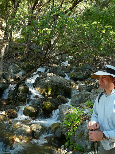
Jeremy's permit was for four people. The roster were all BPL'ers, including Jeremy, Jay, Cameron and me. I was a late addition to the program, I was lucky enough to take the place of someone else who had to bow out.
The Hike:
Our destination was a loop hike in the Grand Canyon of the Tuolumne River. The planned route followed this path (see Tom Harrison Maps, “Yosemite High Country”):
Trailhead: White Wolf 7875'
Day one: Pate Valley 11.4 miles 4380'
Day two: Glen Aulin 14.2 miles 7840'
Day three: Ten Lakes Pass 16.7 miles 9628'
Day four: White Wolf 8.3 miles 7875'Not all of us completed the original itinerary, but more on that later.
The weather was great, but it's been a long and snowy winter in the Sierras this year, so we were unsure what the conditions would be like on the ground. We figured we would take what Yosemite gave us and stay flexible. When we arrived at the White Wolf Trailhead turnoff we discovered that they hadn't opened up the gates yet. We parked alongside Highway 120 and set out from there, the first mile or so of our hike on the paved road into the resort and the trailhead.
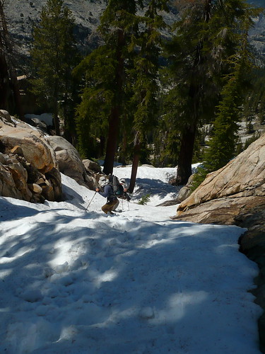
Once we got on the actual trail we moved along at a pretty good clip considering how much snow was on the ground. The trail rolls up and down for almost four miles then starts to drop to the right (East) to descend into the Grand Canyon of the Tuolumne. And it drops fast. We lost 2600' feet in roughly four miles. It seemed like a lot to me. Cameron pointed out that we were essentially putting the brakes on for our skin-out weights with each step, over and over and over again.
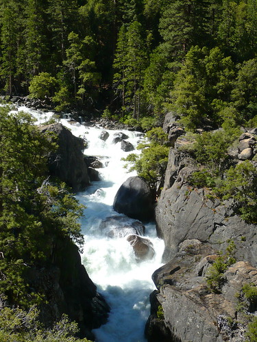
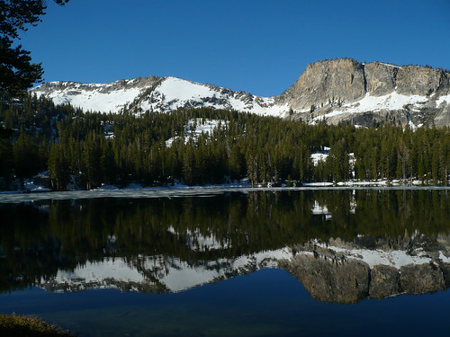
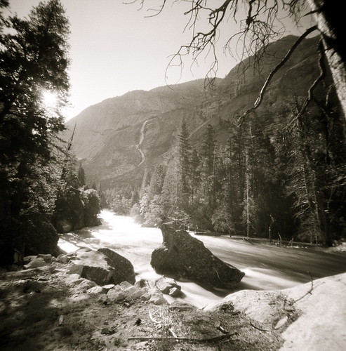
As we dropped into the Canyon we were treated to outstanding views of Hetch Hetchy Reservoir. When we arrived at the leading edge of the Pate Valley we joined up with the Tuolumne and it was BIG. Lots of water moving very fast. We continued along the river until reaching a nice, flat, roomy campsite just short of the bridge.
The evening routine was…….routine. Jeremy and I got in a game of dominoes.
We were up and moving early in the morning, crossing the Tuolumne via a bridge and starting up the Canyon itself. There is no good camping nearby on the far side of the river, at least not with this much water around.
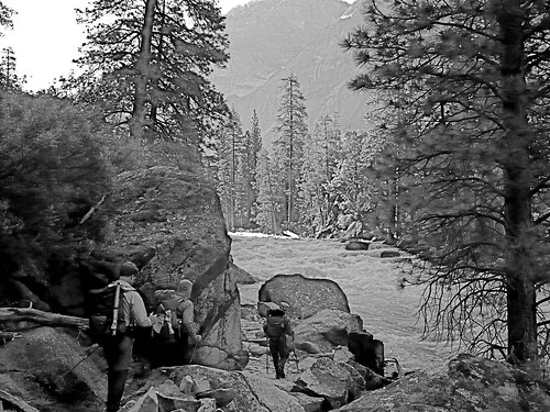
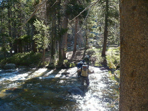
It wasn't long before we came across a rather daunting obstacle. The Tuolumne was so high that it completely covered the trail, washing up against a granite wall. We had a choice, abandon the trip and retrace our steps back up to White Wolf or wade the river. There was really no discussion, we had a close look and sent Jay out into the river. He got through, so we all gave it a go. It was pretty sketchy. The footing was good, as the trail was made up of stones laid out like a roman highway, but the stones were under two feet of very fast moving water. While a slip was not likely, the consequences would be huge. I think we waded three more short stretches of river like this and several more easier segments.
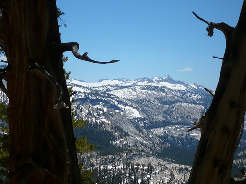
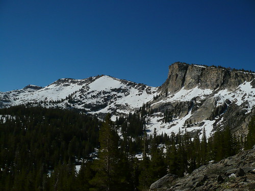
This part of the hike was very slow as we negotiated the river. We had a snack on a granite ledge opposite Colby Mountain and Grand Mountain (peaks which I think will play a role in the second half of this story), then we arrived at the big climb just as the sun was really starting to beat down. There is an excellent campsite at the junction of Return Creek and the Tuolumne.
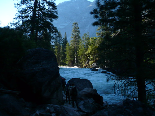
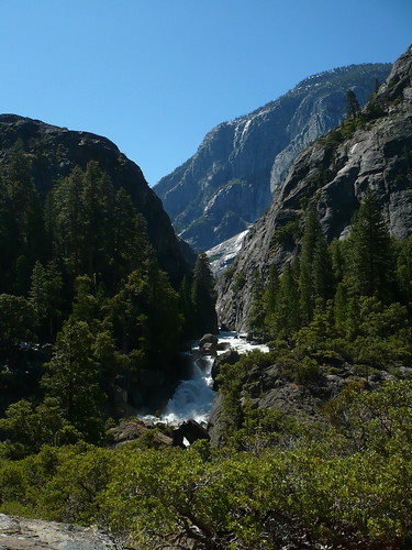
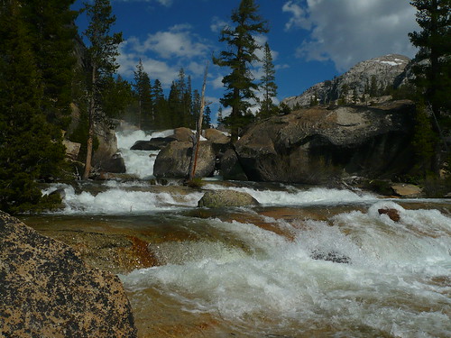
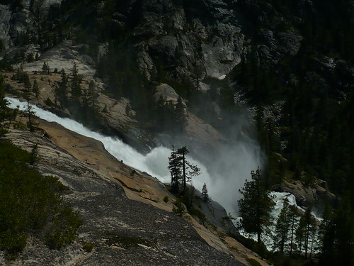
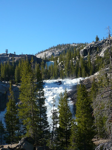
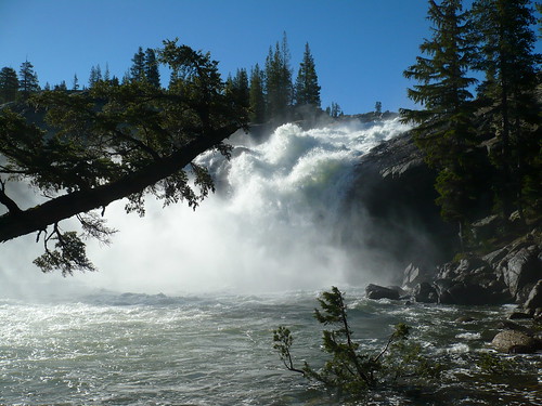
The climb was long, hot and difficult. In the morning I was hyper aware of snakes, this was prime rattler country. But in the afternoon I couldn't care less, “Bite me please, just make it quick!”. But the payoff for the all the work was in the view as we approached the end of the Canyon. Water Wheel, Leconte and California falls were all massive, just incredibly spectacular.
We arrived just short of Glen Aulin after about eleven hours on the trail and set up camp. I, for one, was completely spent. It's not that I just felt tired, I felt unwell. I broached the subject of bailing out on the remainder of the trip. There were options available for an easier way out and I was giving them serious consideration. The others made a game, low pressure effort to convince me to stick with it and I decided to delay a final decision until morning.
Way too tired for dominoes on this night.
In the morning we were up early again and underway by seven. I felt better and decided to try it out for a while. The trail out of Glen Aulin en route to Ten Lakes Pass starts out very mild for the first four miles or so. Even so, I was barely making it and was just trudging along one step at a time. It was becoming apparent to me that I wasn't going to make the day.
In the morning Jay had approached me and said “Hike your own hike. Do what works for you, don't worry about us at all.” He gave me “permission” to think for myself and make a decision that was best for me without feeling a self-imposed pressure to keep up or complete the trip. This was an immense help. I found his words very thoughtful and backcountry savvy.
You know how when you watch a good tennis player or skier and they make it look easy and effortless? That's Jay in the woods – 100% at home. That's not to take away from Cameron or Jeremy. Both are strong, accomplished backcountry walkers and excellent hiking partners.
At any rate, I ultimately decided to turn around just short of the junction with the trail leading up to Ten Lakes Pass. We decided I would return to Glen Aulin for the night, then exit to Tuolumne Meadows in the morning. The rest of the group would continue to Ten Lakes Pass, then on to White Wolf and meet me at the diner in Tuolumne Meadows.
The others have quite a story to tell about their adventure the rest of that day, night and the next day. Hopefully one of the guys will share here.
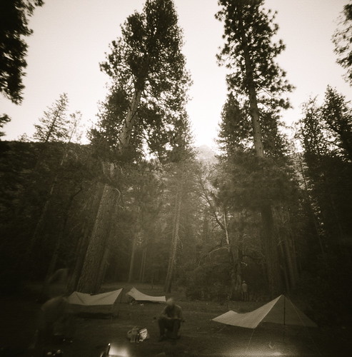
My story is more dull. I returned to Glen Aulin around noon and found a nice campsite in the woods just downstream from the High Sierra Camp. I rolled out my ridgerest pad and laid down for a second. Next thing you know, I was waking up from a nice nap. I had hours to kill before dark, so I set up a schedule. Gather firewood, mess around with my tarp, read, take some photos, eat dinner and dessert, make cocoa, hit the sack at 9:00. Glen Aulin is a beautiful place to camp, by the way, and easy to get to from Tuolumne Meadows. Not remote, but a great spot anyway.
In the morning I was feeling much better and hit the trail by 7:00 and was in Tuolumne Meadows by 10:00. I asked the first couple I saw where the diner was. They said “Oh, you mean the restaurant, it's closed”. I told them that was ok. I just needed to know where it was. “But it's closed”, they said. Ok, thanks a lot then. I walked over to the visitor center. I told the ranger there about the trail conditions in the Canyon and asked where the diner was. He said there was no diner, but the ranger working next to him interrupted and said, “You mean the grill? It's about a mile that way”. Ok…the grill it is then!
I made it over to the store next to the closed grill and gorged on a constant stream of junk food and enjoyed some excellent people watching. Lots of “dirt bag” PCT through hikers around, characters all. And I mean that in the best possible way. They were already lean and mean, tanned and lined and mailing home their ice axes.
The rest of the group showed up exactly on time at 2:00, we took off toward home, sharing stories the whole way.
This is a spectacular hike, even just the part I did. I had a great time, suffering and all, and experienced some great scenery.

White Wolf Resort, closed.

Alpinlite Strat I tarp, Katabatic Pinon bivy, GoLite Jam 2 pack in "Ben2Blue", Coors 24oz.

Jeremy is prepared for rain or wind, but not rain AND wind.
"So, what you do, Cameron, is you place your feet about shoulder width apart, put your hands on your knees and squat down. No problem."
"You want ME to go first?"

Glen Aulin Falls

Home Sweet Home

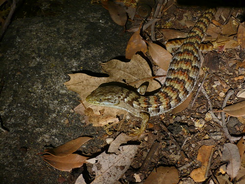
This guy came out and did some push-ups for me at breakfast. Show off. I don't know why he thought he was so cool, half his tail was missing.

Really cool natural sluice at Glen Aulin.
I guess they're not sure if this is the visitor center.
Jun 30, 2010 at 2:07 am #1624780Thanks for starting the trip report Daivd, nice report on the trip.

Jay will know what this is . . .
Starting the trip,
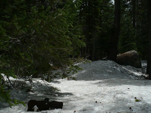
Lots of areas were snow free, some soggy.
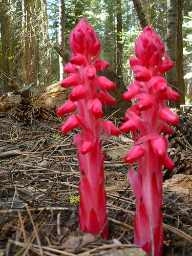
Snow plant
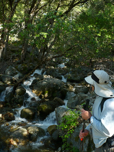
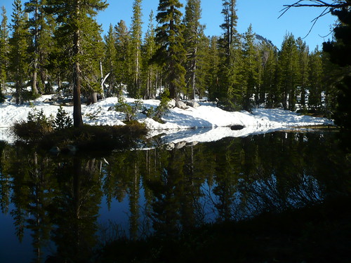
With the melt going on, water was plentiful
Jay is pleased with the way that water was flowing
preparing to start the wade upstream
Here we go !
Near Muir gorge
The water was well oxygenated, and cold. Tasted a little dusty.
I think this might be register creek
more of the tuolumne river.
waterwheel falls
california falls I think. I lost my map in a yard sale.
Glen Aulin falls.
creek crossing
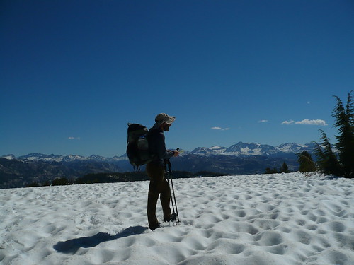
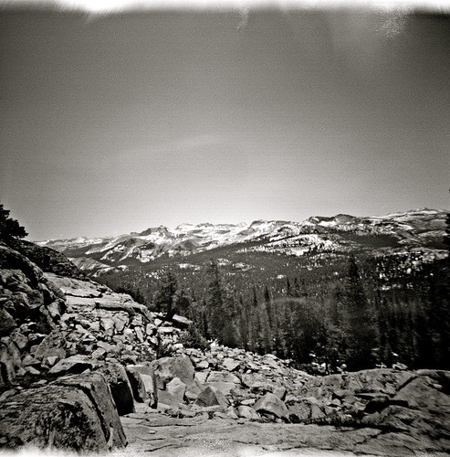
The views were awesome
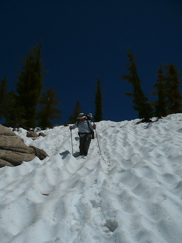
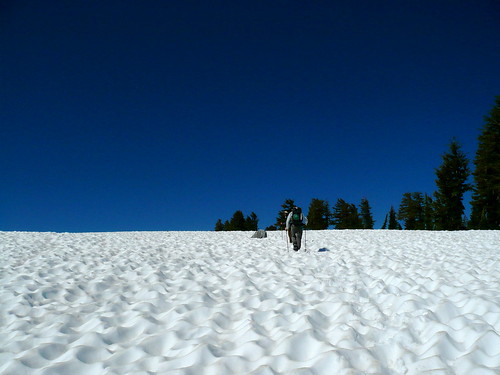
Snow play
Once we get down the snow, we get to the rock scrambling.
We were only about 500 meters off course, and a few hundred too high.
A shortcut, really.
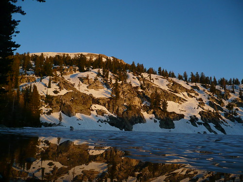
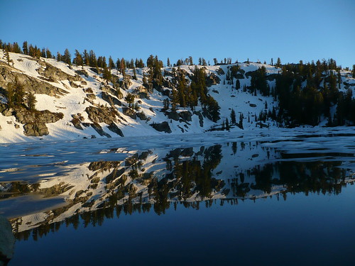
One of the ten lakes
campsite views from one of the ten lakes
more views from the campsite.
Wandering around the ten lakes before making our way out
climbing out to the ten lake pass
Jay and Jeremy going up the snow field to the pass
Jeremy taking in the viewsImagine there was a picture of us at the meadows with fine IPA in hand.
Jun 30, 2010 at 4:44 am #1624802Wow, my kind of trip, looks excellent. The Tuolumne moves a tremendous amount of water, the sound near the falls must have resembled a jet taking off next to your ear.
Jun 30, 2010 at 5:53 am #1624820Jealous of course. Who wouldn't be. Fabulous.
Jun 30, 2010 at 5:59 am #1624823thanks for sharing, great pics.
Jun 30, 2010 at 7:44 am #1624849Great trip report David–I wish I had writing skills apposed to outdoor skills. Thanks for the kind words….
Here is a few pictures:
Just north of Hetch Hetchy Res.
Dave plotting our route.
This one picture really says it ALL about our Adventure!!!

What a view from the top….
"No Comment" I leave this to the imagination….
This was the last day exit strategy..Jun 30, 2010 at 9:53 am #1624902A great tale well told by all. Thanks for sharing, guys!
That, is a LOT of water.
Cheers,
Rick
Jun 30, 2010 at 11:13 am #1624917Great trip guys….David, sorry that you couldn't continue on with the rest of them, but thanks for sharing with your gift of writing.
Love the photos too….great stuff.
I sooooo want to get out and take a trip!
-Tony
Jun 30, 2010 at 12:43 pm #1624942
Flooded trail in Glen Aulin–
Peaceful Tuolumne River
Roaring Tuolumne river
Incredible, panoramic views!!!!Jun 30, 2010 at 1:08 pm #1624949More photos, please!!!
Do you have any shots of gear/camp setups?
Always nice to see what everyone was using.
Crazy amounts of water blasting down the river.
-Tony
Jun 30, 2010 at 1:21 pm #1624954Thanks for sharing the trip report and all the pictures. That is some amazing stuff. I love to see all that snowmelt blasting downstream! Great stuff!
Jun 30, 2010 at 9:55 pm #1625174A little bit on day 3 and 4. After Dave turned back, Cameron, Jay and I pushed on toward Tuolumne Peak. The snow started getting thick, and the trail hard to find, but we found the half-snow covered turnoff toward the peak. Once we got out of the trees onto the Southeast facing switchbacks, the snow was gone and we had a nice lunch near the top of the switchbacks overlooking some spectacular yosemite peaks.
After lunch, we found ourselves completely in snow once on the North side of the peak. We all took out map and compass and carefully decided which way to go. Jay wanted to go West around the peak; Cameron and I thought down a gully and over a ridge directly in front of us was the place to go. Thus, on a 2-1 vote, we promptly decided to head down a snowy gully, carefully cross a snow bridged creek, climb out of the snow rock scrambling up a ridge, only to realize we had gone the wrong way. Now, we consulted Cameron's GPS and headed toward the trail. After trudging through snow we got to within 0.25 miles of the trail. Unfortunately, it was also several hundred feet below us, leaving us a somewhat sketchy snow and rock scramble down to get back to the trail.
Eventually we made it down, where we ran into a group of heavily-laden traditional backpackers who told us they had tried to follow the trail in the other direction, but had given up due to the heavy snow and non-existent trail. They were surprised to find out we had made it through (though we'll never know if we would have made it on the actual trail route since we got lost and ended up scrambling down a gully).
We finally got to Ten Lakes, where we set up camp and enjoyed a beautiful evening, except for Cameron's serious altitude sickness. I won't go into details, but just think backpacking food meets nausea, and you get the idea.
The next day we started out early toward Ten Lakes pass and promptly got lost in the snow again. We almost headed back down into the Grand Canyon of the Tuolumne. Considering we each had one ProBar left, that would have been bad. Eventually, the GPS saved us again and we made it up and over the pass. Eventually, we decided to shorten the trudge through the snow by taking a trail down to Yosemite Creek on Tioga Pass rather than going all the way to White Wolf. Jay eventually thumbed a ride back to Dave's car, and then we went up to Tuolumne to pick up Dave and head back to civilization.
Overall, lots of high fast water and snow, no permanent injuries (our egos were bruised for having to fall back on GPS, but they will heal), and one heck of a good time.
Here are some of my photos:
Starting out on the road to White Wolf because the gate was closed.
Dave getting one of our first looks at the canyon
Looking back toward Hetch Hetchy
BPL tarp and bivy city invades Pate Valley
The Tuolumne overfloweth
Looking up the Canyon
Muir Gorge
Tired Jay keeping the skeeters out
From near Waterwheel Falls, looking back down the Grand Canyon of the Tuolumne
Cameron photgraphing Waterwheel Falls
Jay walking the flooded trail near Glen Aulin
Falls just below Glen Aulin
Yosemite expanse viewed from switchbacks near Tuolumne Peak
Jay photographed from both directions as we go the wrong way
Hmmm. . . the trail is down there somewhere
Jay communing with a local resident
Instead of crossing the base of Tuolumne Peak, where the trail is somewhere under the snow, we ended up in one of the gullies to the left of the peak
Ten Lakes
snow adjacent bivy at Ten Lakes
Ten Lakes reflection
Jay climbing Ten Lakes Pass
Jul 1, 2010 at 9:51 am #1625284Jeremy,
What were the night time temperatures like and was your Golite Quilt able to keep you warm enough.
Looks like you ran into heavy bugs requiring the head nets too.
Man, traversing those fields of snow must have been something!
-Tony
Jul 1, 2010 at 10:01 am #1625288Last weekend I was on the other side of Mount Hoffmann from where they were. The sun cups were about a foot deep, and that was very tiring to traverse. For a steep ascent, it was kind of helpful, as long as we didn't fall.
–B.G.–
Jul 1, 2010 at 11:24 am #1625346I see your post is 6/30, when was your trip? Just a couple days ago? I am going on a reverse of your trip starting next Tuesday, and folks in our group are reluctant, worried about the safety of the creek crossings. I wonder if one of you would be willing to give me a call today before 5. Five-five-nine, 561-6556. Thanks
Jul 1, 2010 at 11:42 am #1625355Keio–We went from 6/25 to 6/28–The Tuolumne River is very sketchy at times–it is Hazardous but possible at the right crossings..I don't know your groups skill level but I would say that it is a (very advanced hike) at this time in late Spring..Hey go for it-life is to short…..Bugs are not to bad yet–get snow cups for your trekking poles for sure…waterproof socks help with all the multiple river and stream crossings…GPS really helps because the trail is covered in snow at times and the trail markings are not well maintained in that area yet. Good luck and get ready to drop a few pounds.
Jul 1, 2010 at 12:20 pm #1625367Thanks for your fast reply!
Thanks, forgot about baskets for poles. I have some Kahtoola MICROspikes I haven't tried out yet (tempted to replace that heavy rubber for some webbing straps), for the loooong snow and suncup traverses. Are the snow fields long enough to warrant lugging them along (vs slowing pace and tiring out keeping traction)?As to xings, I am pretty experienced (forded the Middle Fork Kaweah in River Valley below Little Bearpaw Meadow in May), but others in my group are less experienced. Where is the scariest spot? Or are there many?
My map shows a bridge at Return Creek, yes? Thanks again! I'm game to try and take it one step at a time, but others in my group want more specific info to decide to start off from the TH.
Jul 1, 2010 at 12:52 pm #1625383Won't need spikes.
River likely to be Lower somewhat, but I'd prefer wading upstream to down.
Easier to climb toluene peak on dry side than snow too, potentially a good reason to go the way we did.
Make sure all
Your party members have poles, you will want them.Boots would be miserable.
Snow bridges likely to be much thinner too.Jul 1, 2010 at 1:20 pm #1625391I know what you mean by hiking upstream, I thought about that, thanks for underscoring. Maybe I can convince trip organizer to reverse her trip direction..
After my last post, I took a better look at y'alls great photos, the snow looks pretty mushy all the time.
"Boots would be miserable"? You mean like high top leather? For me boots are always miserable, even when I have to wear them in winter.. Did I miss something?
Thanks for everything, guys.
Jul 1, 2010 at 1:47 pm #1625402Keio, We all hiked in running shoes- no Boots..The running shoes dry very quickly after river crossings as opposed to leather boots..Boots would of been better say a month ago (more snow)…
Jul 1, 2010 at 1:57 pm #1625406If I remember right, there is a bridge at Return Creek. You have to wade the crossing at Register Creek, which is a little scary.
The worst parts were wading the Tuolumne were it flooded the trail toward the bottom of the canyon. I would feel much better going upstream than down.
The payoff for dealing with all the water are the spectacular waterfalls. As Cameron said, the river is likely down a bit by now.
How many days are you taking to complete the trip? I would do at least five. It's a burner. All the way down, then back up, then up some more (the part I missed). The members of our group that completed the route in four days are all VERY experienced in the backcountry, and strong.
Jul 1, 2010 at 8:04 pm #1625553Tony: Night time temps in Pate Valley (between 4-5,000 ft) were "warm." I was too hot in the quilt. Second night they were "comfortable" at 7800 ft. Third night they were close to freezing but still pretty warm considering all the snow and ice around (approx 9500 ft). The quilt was plenty warm. I have no idea actual temps.
Bugs were out, but not as heavy as I expected, though one shoulder got a lot of bites.
Snow was fun, and actually easy on the feet. For once, I went 50 miles without blisters. I think all the time spent in cool water kept my feet from swelling, which is the typical reason I tend to get blisters.
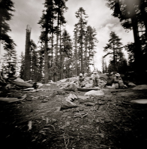
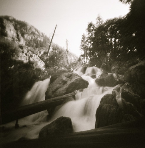
Jul 3, 2010 at 7:49 am #1625943
Pinhole optics, holga body.
Jul 3, 2010 at 8:18 am #1625952Holga! Nice :-)
Cheers,
Rick
Jul 3, 2010 at 6:55 pm #1626072""No Comment" I leave this to the imagination…."
Was there a backpack under the sleeping bag, bear cannister, pad, etc.????
-
AuthorPosts


- You must be logged in to reply to this topic.
Forum Posting
A Membership is required to post in the forums. Login or become a member to post in the member forums!
Our Community Posts are Moderated
Backpacking Light community posts are moderated and here to foster helpful and positive discussions about lightweight backpacking. Please be mindful of our values and boundaries and review our Community Guidelines prior to posting.
Get the Newsletter
Gear Research & Discovery Tools
- Browse our curated Gear Shop
- See the latest Gear Deals and Sales
- Our Recommendations
- Search for Gear on Sale with the Gear Finder
- Used Gear Swap
- Member Gear Reviews and BPL Gear Review Articles
- Browse by Gear Type or Brand.
