I've got a trip planned for the first two segments of the Grand Enchantment Trail (46 miles) starting december 17. I'm a lifelong resident of Wisconsin next to Lake Michigan, so I know what to do WITH water. I could use comments/suggestions on what to do WITHOUT water, as I hear that area has been going through quite a drought. I'm also new to desert camping and hiking, so any and all advice is welcome. Thanks!
Topic
Drought in the Superstitions- Help!
Become a member to post in the forums.
- This topic is empty.
Travis, I have hiked the Sups a few times and have been able to find water in springs every time I've been. I don't want to blow smoke though, so i'll try to make at least a day hike trip to look for water sources.
Have you looked a your trip in fine detail? Do you know the water sources that should exist in a normal year? If so, you could start with contacting rangers and asking if those sources are dry.
Brady, that'd be great! Darn, another excuse to go hiking, huh?!
Is there indeed a pretty bad drought now? Any tips on desert hiking? I know how to bear bag my food, but what about all the little desert critters getting into my stuff? I guess anything you could tell me about the area would help. I have family in Glendale and have been there many times, but never in any sort of hiking/camping context.
Jack,
Yes, I have talked briefly with Brett Tucker, who I think runs the Grand Enchantment Trail website. It lists water sources and reliability, but not since Spring of this year. Normal rain is about 8.5 inches per year, and I think this year is only at 2.5, so I"m a little leery of the water situation. I've also gone through the trail guide on Brett's site, step by step, and following along with the topo maps.
Travis,
If water is normally available, and the location is a critical refill point, then you MUST verify from a reliable source that in fact water is currently available. No verification then no go, unless you carry enough water in reserve just in case!!
Plan on needing a minimum of 1 gallon of drinking water per person per day. Water is heavy, so if there are long stretches between verified water sources, you may want to eat meals that do not require water for preparation or clean up.
Desert hiking in December is awesome. Check the temperature forecast, as high and lows can be 50 degrees F or more difference.
please describe your planned itenerary, and i can assist you in determining where to find water in the Supes.
True aquifers need no rainfall. however, places like Reavis creek have been running lower than recorded back in 2000 or earlier, but still are running. LaBarge, Charlebois, and Kane springs for instance have great water. you can also visit http://www.hikearizona.com for more detail.
Current info from the Grand Enchantment Trail forum:
http://groups.yahoo.com/group/grand-enchantment-trail/
· I left Superior with 12 liters of water. I was planning on making it to Charlesbois without finding water.
· Whitford Canyon – Dry
· Reavis Trail Canyon – Pools just north of the stone coral. Pools and flow where the trail crosses at N33 22.763 W111 08.435.
· Rogers Canyon – dry
· Clover Spring – dry
· Nighthawk Spring, La Barge Spring #2 – DNV
· Upper La Barge Box – Dry
· La Barge Spring – pool in drainage and good flow from tree roots on bank.
· Charlesbois – DNV [considered reliable]
· East Boulder Canyon – dry
Travis – if you can possibly find a way to cache water near Rogers Trough Trailhead (4WD-accessible only as I understand it), then this would really help, esp. in the event that Reavis Trail Cyn goes dry between now and your arrival date.
I would plan on a pace of no more than 12 miles per day for a newcomer to the Superstitions, especially in winter with short daylight hours.
1.5 gallons of water per day (incl. meals), give or take.
Snakes and scorpions will be dormant. Bears (any that might be active then) in the western Supes (along the GET) are much less common than in the higher, forested eastern terrain.
Sounds like fun to me! But why are you posting on BPL when the GET has its very own forum? ;-)
Touche, Brett! Thanks very much for the detailed information. It will certainly be of invaluable use to me. I'll take some time to look over stuff, and if I have any other questions, maybe you'll see me over at GET forums!
Edit: I've got a membership pending over there…until then, I google-mapped the area, and I've "routed" the dirt road at Rogers Trough Trailhead back to Route 60. I'm guessing this is really the only point to cache water? If you or anyone you know has any details about caching water here, i.e. specific driving conditions from US 60, it would be of help. Thanks yet again!
te-wa (mike?)– I'm planning to hit the trailhead at the western terminus (First Water Trailhead) on the early morning of December 17th. I'm doing the first two sections, and planning to be picked up in Superior. I'd like to do it in 4 nights, 5 days, averaging 11 miles a day, but may have to alter plans due to water. Thanks a bunch!
from 1st water t/h you will find water at charlebois and labarge, both only 1 mile apart from one another. given that fact, labarge is more reliable of the 2.
on to the hoolie bacon trail water was in Kane spring and looks to hold water year round.
i agree to cache water @ Roger's trough t/h, although any medium clearance vehicle can make the newly graded road. i was just there 2 weeks ago and plenty of passenger cars/low clearance suv's (honda crv for example) were there. only a shallow sandy wash could cause any issue. DONT stop in the sand, youll make it thru fine.
after that the only water source i know of is the spigot on the side of Circle K store
Te-wa,
I've looked on my topo maps, but can't find Kane spring marked. Do you know what mile marker its at?
As far as the road to Rogers trough, is it easily marked via US 60? Which way should I take?
Edit: I only ask about the road because at least up in Northern Wisconsin, the forest roads are sometimes poorly marked, and can occasionally be mistaken for well-traveled fire lanes or ATV trails.
Kane Spring looks to be on Peters Trail 105, which the GET doesn't use. And the spring location doesn't show on the GET-specific maps. Approx location N 33 28.554 W 111 18.451. Signed Peters Tr junction just S of Charlebois Spring will lead past the spring as the trail approaches Tortilla Creek. Tr ends at Tortilla Well (now on the GET map again) where you would join JF Trail 106, soon back on route. This actually looks to be several miles shorter than the suggested route, but misses Upper La Barge Box, which is ooh-ahh nice. Can anyone comment on scenery along Peters Trail?
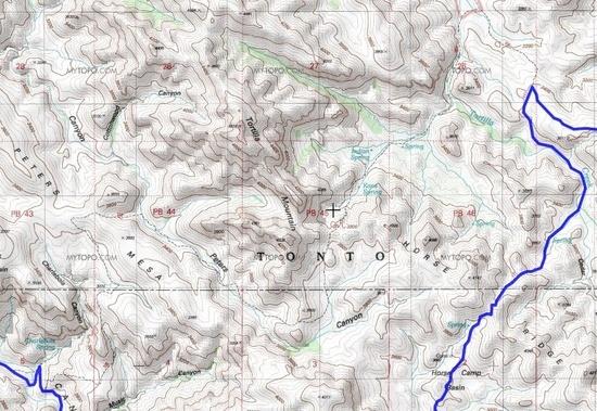
Map attached below – blue line is GET. Hard to read, but Charlebois is at bottom-left, blue lettering; Peters Tr heads over toward Peters Canyon, and then past Kane Spring (ENE of crosshairs). Rejoin the GET at the dogleg in the blue line at right. (This is all hypothetical.)
Also, Mike, thanks for the update on road access!
Ah, you guys are awesome! Brett, I posted a little something over on the GET forums regarding caching water. This has certainly been a learn-as-you-go experience for me, and I already know much more about how to handle this than I did a week ago!
thanks brett for the clarification on Kane, i dont have my map in front of me and it was an error on my part. either way, if you needed water from Kane it is just a simple short detour that ends at the same general area. there is a windmill at the Peters trail and 100 yards to the east is where the JF trail starts.
US 60 to Queen Valley road (just east of the defunct "town" of Florence Junction.)
after about a mile in QV road you'll see a right turn on a dirt rd. called Hewlett Station – take this about 3 miles to fr 172 turning left to go north across the wash and then you'll come to an intersection at 172A which will take you to a large parking lot. this is Roger's Trough trailhead.
Thanks te-wa!
Mike – How would you rate the reliability of Kane Spring compared to La Barge? And what about that windmill? Is that at the Tortilla Well trailhead?
Brett,
On the map from your CD, I see a little trail just south of Horse Camp Basin, I believe is part of Peters trail. You warn to stay away from this "abandoned" trail in the guide in order to stay on the marked route. Could you still hit up Kane Spring this way? Or is that part of the trail too ambiguous to travel anymore? That way, I'd still get to see Upper La Barge Box, and maybe find water at Kane Spring also. Pending verification, that puts a water source about 16 miles into the trek, which may help a lot.
The only way I'd do it via Upper La Barge would be to stick with Hoolie Bacon to JF Tr then N to Tortilla Well TH. If the supposed windmill there has water, major mileage savings. Otherwise press on W via Peters Tr to Kane Spring, then double back to JF, 4 or 5 miles round trip detour. Detours like this can be more palatable if you plan to camp en route.
If I got stuck out there without water, and couldn't find any on such a detour, I would double back via Peters Trail to Charlebois or La Barge Spring, and either load up for the push to Rogers Trough or return to the starting point, depending on available time and motivation.
the windmill is in disrepair.. only the tower stands.
Peter's Mesa is the high point of the Peter's trail and affords great views in all directions. If you get water from charlebois then it makes sense to climb Peter's trail which starts a mere 100 yards away, and you will miss the Upper "Box" but by doing that you'll also miss the catsclaw nightmare that will destroy anything not made of Dyneema, including your skin. The Red Tanks trail is usually not very well maintained and if it has been then its been done by fellow hikers. The forest service usually does nothing outside of sit inside their $40,000 trucks and sip coffee. I actually had a female ranger ask me to go to charlebois spring, and call her office later to tell her what the condition of the trough was!! (trough contained a habitat of endagered Gila topminnows)
Its a real tough call on my behalf to give advice on which area is more scenic. The upper box is nice, but the views from Peter's are equally, but differently, nice.
one last suggestion: get the "Beartooth" publishing Superstition Wilderness Map. cost about $12 worth every penny.
Thanks Mike.
By the way, Travis, catclaw is type of aggressively thorny shrub common to the Sonoran desert. It's mostly an unavoidable nuisance here, regardless of which trails you choose to hike. Arizonans love to haze newcomers with dire warnings about catclaw (among other localized species of flora & fauna). The reality is that there are far worse plants to mess with than catclaw (such as jumping cholla), and most of these are easily avoided with care. As for catclaw requiring bulletproof armor, in my experience it is a myth. I carried a homemade sil-nylon pack on my first GET hike and it wasn't affected at all by the plant life. In fact the tight weave and slippery nature of the fabric gave the thorns no purchase, and they just brushed on by with the rest of the plant.
Haha, thanks for the heads-up. When I was a kid, we visited my aunt in Phoenix–who by the way is a big reason why I chose this hike due to proximity to the trailhead, among other things like awesome scenery!–anyways, when I was there, we went on a few very pedestrian day hikes and was "warned" of some sort of cactus that if we got too close, would jump at you and stick you! Is this the jumping cholla you speak of? I also remember flipping over cow dung to find scorpions…
On a more serious note, I believe I'll be able to cache water at Rogers Trough Trailhead. I think I left out the fact that I'm hiking with my girlfriend, who's quite small at 106 pounds, and unable to carry the water weight I can. I'm going to have the capacity to carry 8 liters of water, and she 4. So thats 12 liters total. If we start out and can fill up at Charlebois or LaBarge, then we would have 12 liters to make it to Rogers Trough, 19 miles away, or about a day and a half. If I fill up at my cache, it'll be about 17 miles to Superior, another day and a half. I think this is reasonable. What do you think? Too little water? Just right? If there was water at the windmill, that would be a huge help. If necessary, I can carry a bit more, and maybe convince her to add one more liter.
This trip is quite ironic because the last one we did was along the Pictured Rocks National Lakeshore in the Upper Peninsula of Michigan. For the ENTIRE 42 miles, we had Lake Superior and its tributaries for a constant water source. We had TOO much water!! My avatar is a picture from then. The cliff you see behind me was about 200+ feet down to the lake. Beautiful trip.
As mentioned, a gallon and half per person per day would be a good baseline. Everyone's needs will be different, though. And temperature will play a major role, obviously.
Plan but don't overplan. Leave room for adventure, and trust your instincts when you're out there. If nature is the catalyst, then she will only change us if we first allow her to act upon us.
You're right. I've done what I can to plan and should now just take what happens in stride!
"Arizonans love to haze newcomers with dire warnings about catclaw"
dang you brett! i was just starting to have fun w/ this guy… lol
more importantly as a severe and serious warning about risks involved and expected in the Sonoran Desert are issues such as hypothermia, exposure and hostile enviromental challenges that far outweigh the goofy and gimmicky legends of jumping cactus and snakes slithering into your bag at night.
be careful out there, and you will have stories to tell your eager listening grandchildren. the superstitions are different than most places people are used to hiking in, and should gain your respect as a wild place that has its share of challenges, but proper planning will avail you the benefit of respect for such an interesting mountain range. it truly is a magic place and one of my favorite places to enter. i hope you take a piece of it home with you to give you lasting memories.
Become a member to post in the forums.
advertisementYour privacy is protected: We do not transmit your user data to third-party ad platforms or advertisers, and we do not host third-party tracking pixels. Backpacking Light serves ads on its own custom, native, and internal platform.
 New Ultralight GearSee the latest releases in ultralight cottage-brand gear from small makers.