Hendrik,
Excellent job at giving us some insight as to who is behind the gear. Truly enjoyed all of the interviews, especially the Fritz Handel one. Keep up the good work!
Topic
Cottage manufacturers – interviewed
Become a member to post in the forums.
- This topic is empty.
It was a bit silent here, with me being hiking. Nevertheless, Here is the next interview, featuring Judy Gross from LightHeart Gear. Interviews should now continue as usual =)
I have really enjoyed your interviews, and have a suggestion for you. Joe from Zpacks.
Hei Gary, thank you! I’d really like to interview Joe, but he was interviewed here not too far back, and I am not certain if an interview with me would add more value at the time being. Maybe later in the spring, though =)
for the link, it was an interesting read.
George Andrews of AntiGravityGear is answering my questions today, and tells what we can expect besides pot cozies from them in the future =)
Well I guess it's time for me to do a little pimping!
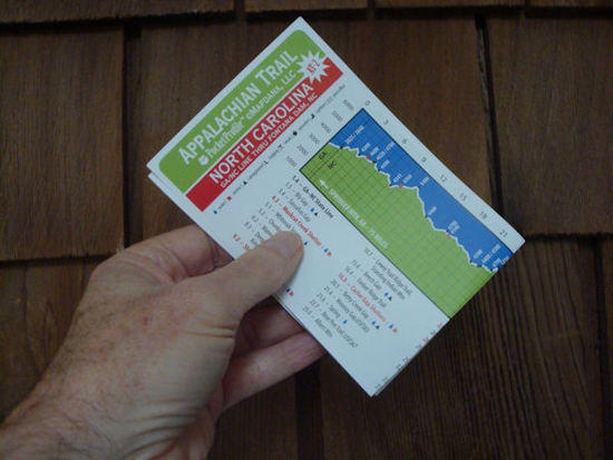
I stopped by George's home shop in early December and he gave me a hand full of those profile maps as a promo-treat. (I kinda figured OK whatever) but a couple of weeks later I did a hike including a stretch of the AT near Standing Indian. I must say those profile maps are perfect. They are tiny compared to a map being 3.75 x 17 inches and weighing 4 gr.

and the one I have at hand covers a 90 mile stretch of the AT. It's Tear-proof & folds up about the size of a couple of playing cards.
The best part is that except for situations where you are switching trails and need info along the new trail…. they actually have more readily available info than either a gps or a contour map providing at a glimpse the trail profile in an easily readable graph format along with the distance to major trail intersections, shelter, water,gaps and peaks, and highway intersections with mileage to adjoining towns for re-supply.
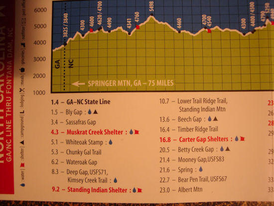
The graphic also includes info on access to food, supplies, water, shelter, motels and etc as shown. ( That's elevation on top of the image and trail miles running down the right side so each cube in the graph is 500 feet of elevation up or down and one mile left and right)
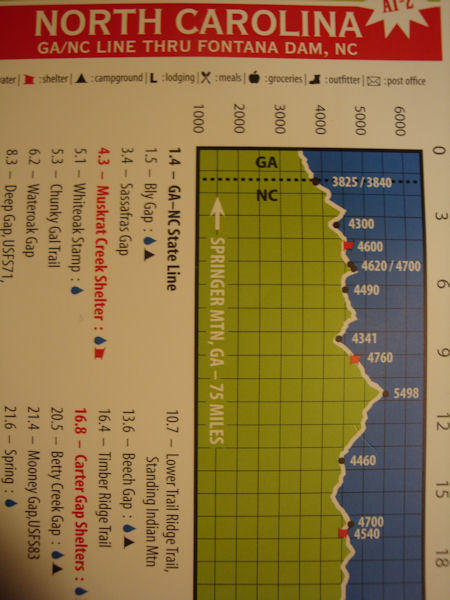
The best part is how easy it is to get the some of the main questions one typically has when on the trail; how far is X and how much of a climb or descent, answered in a flash. No more waiting for a gps signal or fumbling with a huge trails illustrated map which really won't accurately ( or hardly even approximately ) answer those questions anyway. How can a gps tell you the distance from Standing Indian to Albert Mountain? Even if you have those points marked it will only give the distance in a straight line. And try calculating the elevation gain and loss. So these are a nice litle tool! Hope they become available soon for lots of major routes…. Like George if you read this how about the mountainous part of the MST here in the good ol Tar Heel State? or the Bartram trail, foothills trail …………etc….etc….
Rod Java from TheStickPic.com answers the questions and tells us that there’s a backpack in the making from their company!
Matthew Lagas-Rivera from Elemental Horizons answers my questions this Monday morning – Enjoy!
Donald Kevilus from Four Dog Stove answers my questions today, so grab a cup of tea and learn about the inventor of the Bushcooker LT!
A relative new cottage manufacturer, Katabatic Gear and its founder Aaron Martray are interviewed this week.
Another great interview!
Brandon Waddy from Warbonnet Outdoors interview is online ^_^
Kim Coupounas from GoLite is interviewed this time, as part of the “Women in the Outdoors” series running this week.
Awesome interview Hendrik! Nice to hear the perspective of a larger company.
These interviews are awesome. Nice work, again!
Thanks Nathan and Steven! It was great to see her answers, and also that she didn't shy away from answering about "GoHeavy" and Ray Jardine which probably was on many folks mind.
Tom Hennessy from Hennessy Hammocks answers my questions this time around. I got another few interviews lined up during the coming weeks, so stay tuned =)
Another great interview! Thanks so much for doing these. I bought my first Hennessey almost 10 years ago. Met Tom at the 2nd ADZPCTKO and bought a set of snakeskins out of the trunk if his car. Great guy.
Eric Hardee from Rivendell Mountain Works interview is online.
Awesome Hendrik – I have been waiting for this one…; )
Mike St. Pierre from Hyperlite Mountain Gear takes time out from managing his young cottage business to answer my questions =)
great series.
Yes, thanks for that. I like Aarn
Franco
Become a member to post in the forums.
advertisementYour privacy is protected: We do not transmit your user data to third-party ad platforms or advertisers, and we do not host third-party tracking pixels. Backpacking Light serves ads on its own custom, native, and internal platform.
 New Ultralight GearSee the latest releases in ultralight cottage-brand gear from small makers.