My college age son is now into backpacking. I always send him a summary of my trips. Here is what I did for Memorial Day weekend.
Trip Description:
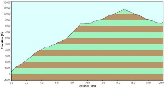
· 3 day loop of the San Jacinto Mountains
· Total Mileage: ~ 61 miles
· Elevation Gain/Loss: 10,568'/10,568'
· Temperature Range: 45F – 97F
Day 1:
Palm Springs Art Museum to Mt San Jacinto (Skyline Trail).
Mt San Jacinto to Little Round Valley.
Elevation gain: 10,568'
Mileage: ~ 17.75
Day 2:
Little Round Valley to Mt San Jacinto.
Mt San Jacinto to Wellman Divide.
Wellman Divide to Saddle Junction.
Saddle Junction to Little Tahquitz Valley.
Little Tahquitz Valley to Pacific Crest Trail.
Pacific Crest Trail to Fobes Saddle.
Elevation Loss: 4,420'
Mileage: ~ 23 miles
Day 3:
Fobes Saddle to Cedar Springs.
Cedar Springs to Jo Pond Trail.
Jo Pond Trail to Palm Springs Indian Canyon Visitor Center.
Palm Springs Indian Canyon Visitor Center to Palm Springs Art Museum.
Elevation Loss: 6,148'
Mileage: ~ 21 miles
Started to think about this trip several months ago. The goal was to hike the Skyline Trail, and put together a round trip route that would take 3-4 days. Hiking this trail and other routes at the same time presents some challenges. Specifically dealing with weather and water. The Skyline Trail begins on the desert floor in Palm Springs and ends at the peak of Mt San Jacinto. The trail gains 10,568 feet over approximately 16.5 miles.
The optimum time to hike the Skyline Trail is May/June or October/November. July – September is too hot, unless you hike at night. This is due to the desert climate over the first 11 miles and an 8,000 foot elevation gain. This section has no water, and daytime temperatures can exceed 100F. During the other months of the year, the hike at the 7,000 – 8,000 foot level can be treacherous with snow and ice chutes. During this period, this section often requires an ice axe and crampons. Most hikers attempting the route in the late spring typically start the hike a couple hours before sunrise to minimize the full sun on the east facing side of the mountain. If "The Loop" is hiked during the months of May or June, water can be found in the streams and springs in upper elevations. Doing the loop in October or early November, water in streams and springs can dry up.
Some facts about the Skyline Trail (also known as the Cactus to Clouds Trail): The trail is known as having the greatest elevation gain of any one-day hike in the continental US. The route crosses through 6 ecosystems, the most of any one-day hike in the lower 48 states. The hike starts in the Lower Sonoran Zone and ends in an Arctic Alpine Zone. It is like hiking from Mexico to Canada in one day.
Some caveats about hiking this trail: It is a cross-country route and not on any map. The first 7,000 feet is well worn and easily identified. The last 1,000 feet (1+ miles) is a scramble up ravines with loose and rocky soil. Navigation and footing are not ideal. There is no water for 11 miles and 8,000 feet of elevation gain. Most people hike the lower 11-mile section, and then take the Palm Springs Aerial Tramway back down. A few will continue to the Peak and return to the Tram, a total hike of 23 miles. The trail requires many Search and Rescue operations each year, and several people have died on the trail, usually during the winter season. The latest fatality occurred this past Sunday, May 21, 2009, due to heat exhaustion. The BLM, City of Palm Springs, and State of California discourage its use, and there are many foreboding warning signs posted on the first couple of miles of the trail. However, with properly planning, water, and equipment Skyline is a great hike. The Skyline-PCT-Jo Pond Loop is probably the most diverse 3-day hike in the continental US… at least in my opinion.
Now for the hike: I had been running and working out at the gym to prepare, but had not been able to do any long preparatory hikes, due to work commitments. I wanted to complete the hike in 3 days, so I could spend Memorial Day at home with my wife. Feeling that 3 days might be a stretch, my itinerary called for 4 days. I didn’t want my wife to panic if I did not make it back in 3, which was my real goal. The route traverses some private lands, the Agua Caliente Indian Reservation, the San Jacinto State Wilderness, the San Jacinto US Forest Wilderness, and the San Bernardino National Forest; requiring separate permits from each Wilderness agency. I obtained the necessary permits by mail a month in advance. Because I was not in optimal condition, I put together a Super Ultra Light Gear list. Total weight of my backpack and gear weighed under 4 pounds, plus my food and water. Although rain was unlikely, I carried a poncho/tarp in case of injury, which would provide shelter in the desert areas. Also to reduce the effort of hiking I wore Cross Country Racing Flats, at 5.3 ounces each instead of hiking boots or trail running shoes. It is estimated that one pound on the foot is equal to carrying 5 pounds in the pack, as far as energy expended. So these shoes weigh half of the lightest trail runners… requiring half as much work to hike. Due to the need to carry extra water, minimizing every ounce is crucial to this trip, and I don’t know of anyone who has ever done the Skyline-PCT-Jo Pond Loop as a single hike.
I left on Friday morning of the Memorial Day weekend, in order to avoid other hikers that are on the trails on most weekends. I hit the trail at 5:30AM, opting to skip the typical pre-dawn start by most Skyline hikers. Upon hoisting my pack, I took out my new camera to take a picture and found the battery was dead. Leaving the camera connected to my computer over night, with the computer off, must have drained the battery. I left the camera in the truck, and saved 5 ounces in weight. So instead of taking pictures of the hike, I will include some Google Earth pictures of the route. The routes are freehand, and are an approximation of the hike. Not having a camera was enjoyable. Instead of looking for photo opportunities, I just enjoyed my hike. By noon, the temperature was 90F. Which was the predicted high for the day. I was lucky on the temperature, as a week earlier the temps had been over 100 everyday.
I only saw one person on the trail, a fellow who was doing a short 4 mile round trip. I carried 4 liters of water, probably 2 liters shy of what is generally recommend for this time of year. Because I live in the desert and am acclimated to the heat, I was comfortable with this amount of water, which weighed almost 9 pounds.
I did see a fox early in the morning. No other notable wildlife was seen in this harsh desert environment, although I was hoping I might chance upon aome Big Horn Sheep. The trail ascends a long ridge and the serpentine route provides alternating views of Tahquitz and Tachevah canyons, along with the pearl of the desert, Palm Springs. The lower section is primarily creosote bush, desert willow, burro bush, and a few ironwood trees. Then, almost as if a line was drawn across the face of the ridge, there was ribbonwood, manzanita, scrub oak and then a few pinion pines. Most of the day was in full sun, although there was occasional shade in stands of ribbonwood. Later in the afternoon finally brought shade of pine and fir trees at around 7,000 feet. Once the last ravine was scaled, I finished the last of the water. I now was in the State Wilderness area, a lush forest of pine and fir trees. This section of wilderness does not feel like “wilderness.” The Aerial Tram deposits thousands of tourists here every year. The trails are more like roads, with log curbs outlining most of the trails in Long and Round Valleys, to keep idiots out of meadows and fragile areas. Hiking toward the Long Valley Ranger Station to refill my water bottles, I passed a pedestal with a sign declaring “Meet Jeff” and describing the Jeffery Pine tree behind it. I say, dismantle the tram, and let the “wilderness area” revert to a real wilderness. And let the people buy books if they want to learn about trees… why pollute the area with signs? Oh, well!! I filled my water bottles, and started the 5.5-mile trek to the peak. Good thing I started my trip on Friday and not Saturday, which would have had dozens of people hiking the trail to the peak, after taking a short ride on the tram. As I hiked through Long Valley and Round Valley, there were a few hikers on the trail. Saw a couple of deer in the meadow in Round Valley. After enjoying the 360-degree view at the peak, I headed down the other side to Little Round Valley for my night camp.
By this time, I was exhausted and my legs were sore. The aches were so bad, I feared that the following morning I might not be able to continue the hike, and would need to cancel the rest of the trip. In addition, to save weight I had only brought a torso sized 3/8” foam pad to sleep on, which might cause me a restless and poor nights sleep on my sore legs. I cooked dinner, took two Advil’s and went to sleep.
Google Earth picture of the Skyline Trail to the top of Mt San Jacinto.

Saturday morning, I stretched my legs and walked around while cooking breakfast (boiling water for instant oatmeal) and felt very good. Amazingly good. My conservative goal for the day was to make camp just past Little Tahquitz Valley. Now I considered trying to hike all the way to Cedar Spring, which would be mostly downhill and about a 28-mile hike. Time would tell. I left around 5:00AM. At 7:30, two volunteer rangers who wanted to check my permits stopped me. They were skeptical about my light gear, but one was very interested in my backpack, after he saw I had hiked the Skyline Trail on Friday. I kidded him that his empty pack weighed more than all my gear. After a friendly chitchat, I headed towards Wellman's Divide and Saddle Junction. The trail was shadded by Lodge Pole Pines, and then changing to towering Jeffery Pines that provided shade to ferns and skunk cabbage, making for an enchanting morning walk.
It was Saturday and the hordes of hikers were struggling uphill from Saddle Junction, and I cruised downhill past them. The temperature was cool and patches of snow still lay along the trail. I greeted many folks, and answered slews of questions about the trail ahead, and made excellent time. At Saddle Junction, the main trail from Idyllwild to the San Jacinto State Wilderness was now behind me, and I would see few other hikers for the rest of the day. From Saddle Junction it is a short hike to Tahquitz Valley and then Little Tahquitz Valley. I hit Little Tahquitz Valley around 10:30AM, and still feeling good, decided to make Cedar Spring the day’s destination, instead of the original plan to camp a couple miles past Little Tahquitz Valley. I refilled all my water bottles, because the next water was at Apache Spring 8 miles away; just in case I needed to make camp before Apache Spring, I wanted to make sure I had plenty of water. Leaving Little Tahquitz Valley the trail connects to the Pacific Crest Trail. This section of the PCT, is called the Desert Divide Trail and the mountain ridge separates Garner Valley and Thomas Mountain on the west from the magnificent desert canyons with their palm tree oasis’s on east. This 20+ plus mile section is my favorite part of the San Jacinto Mountains. The granite mountain and the trees are reminiscent of the High Sierras. The miles rolled by and most of my time was occupied with high mountain vistas. My legs started to tire by the time I got to the Apache Spring trail junction, but decided to keep on going.
During a steep, narrow section, several hikers were headed down hill towards me. I stepped to the side to let them pass. The last person slowed to look at my gear and hesitated. He looked familiar, and asked him if we had met before. We had not and he introduced himself as Glen Van Peski, the owner of Gossamer Gear, whose backpack and hiking poles, I was carrying with me. We talked for a few minutes. Glen is a real gentleman.
My hike continued and as I hit Fobes saddle, the wind was blowing hard. Decision time. Should I continue the remaining 5 miles to Cedar Springs, on the windy, exposed ridge, or just stop. If I stopped, then I would be hiking during the heat of the next day descending the Jo Pond Trail into the desert. However, continuing with tired legs and extreme wind could lead to an injury. Common sense prevailed, and I stopped and made camp in the protection of a grove of scrub oak. After an enjoyable meal of freeze-dried spaghetti and meatballs, I took two more Advil’s and went to sleep well before sunset.
Google Earth picture of day 2, Little Round Valley to Fobes Saddle.

Sunday morning was calm and clear. I felt even better than the previous morning. Met two hikers on the trail, and then a group of mountain bikers who were packing up their camp at the Cedar Springs. These would be the only people I would see all day, until I got to the Indian Canyons in Palm Springs. The hike from Fobes Saddle quickly changed from scrub oak to a forest of pines, firs, and sycamores. Saw a couple mule deer in a meadow. The trail soon mounted the ridgeline along corridor of huge manzanita bushes. Most were above my head in height, and in full bloom. For maybe two miles the drone of millions of bees collecting nectar was all I could hear. Got to Cedar Spring early in the morning, filled the water bottles and took a rest and a check of the topographical map. And then I made the one bad decision of the trip.
Looking at the map, I noticed an old trail I had hiked many years ago that would intersect with the Jo Pond Trail. I decided to head cross-country and pick up this trail. The route was over grown with brush and was difficult going. I caught a branch on my pack and ripped a 1” tear in the side pocket of my pack. At this point it was best to abandon the exploration, and I turned back to take the Jo Pond Trail down into the desert and the Agua Caliente Indian Canyons. The start of the Jo Pond Trail is shady among the tall Incense Cedars. However, it was short lived and I soon was in the open on a flat plateau heading down canyon. The way down is not really a trail, but a 8 mile route over scree, talus and rocks. Soon the bottom of my feet began to tire from the beating on the thin soles of the racing flats. The rocks did tear some of the sole material from the shoes, but they held up and got me through it. Other than the inability of these shoes to hold up over time, I was thrilled with their performance. 60+ miles, no break-in period, and no blisters! My son who is a distance runner on his college team, told me that he quit using the Asics Piranahs, because they don't last. He has switched to the Asics Hyper Speed 3, and suggested I do the same if I want to use racing flats for hiking.
Soon the temperature hit 97F, 7 degrees warmer than the forecast three days ago (who can trust a weatherman anyway?). About a mile from the Indian Trading Post, I drank my last liter of water. The trail had been unprotected from the sun for nearly 8 miles, and the cool shade of the Palm Oasis was a welcomed rest. Stopped at the Trading post, bought a double popsicle to cool off and two liters of water. The journey was almost complete. All that remained was a long walk to downtown Palm Springs where my truck was parked. Got in the truck and called Joyce to surprise her, since I was home a day early. She cooked us a huge pile of fried shrimp and we relaxed. It was good to take a shower and sleep in a soft bed.
Google Earth Picture of Fobes Saddle to the Indian Trading Post and then to the Palm Springs Art Museum.

Google Earth picture of "The Loop"

GEAR LIST
Pack:
Gossamer Gear Murmur Pack 6.8 oz
Shelter:
MLD 2mm XtraLowStretch Guyline 1.0 oz
MLD Silnylon Pro Poncho/Tarp 8.8 oz
MLD Titanium Stakes (6) 1.8 oz
Sleeping:
GG 3/8" Foam pad cut to torso 2.6 oz
GGr Polycryo Ground Cloth 1.7 oz
Nunatak Arc Specialist Quilt 15.8 oz
Clothes in Pack:
Montbell Ex Light Down Jacket 6.1 oz
Montbell U.L. Windshirt 2.7 oz
OR PS50 Watch Cap 0.8 oz
Smartwool Glove Liners 1.5 oz
Smartwool Walking Socks 1.7 oz
Kitchen:
Caldera Cone, Stove, & Keg 3.8 oz
Platypus 1 liter water sack 1.8 oz
Platypus 2 liter water sack 1.3 oz
Snowpeak Titanium Spork 0.5 oz
Utility:
Dr. Bronner's soap 0.5 oz
Finger Toothbrush 0.05 oz
First Aid/Emergency Kit 0.6 oz
Spares Kit (Cuben Fiber sack) .06 oz
Spares Kit (matches) 0.1 oz
Spares Kit (Micropur tablets) 0.2 oz
Toilet paper (10 sheets) 0.2 oz
Carried or Worn:
Bandana 0.9 oz
Book of matches 0.1 oz
Fox 40 whistle (on lanyard) 0.2 oz
GG LightTrek 4 Trekking Poles 6.8 oz
Maui Jim Sunglasses 0.6 oz
Nylon Lanyard with Clip 0.8 oz
Photon II MicroLight(on lanyard) 0.4 oz
Sun Thermometer (on lanyard) 3.0 oz
Swiss Army Classic Knife 0.7 oz
Timex Expedition Watch 1.2 oz
Fisher Space Pen 0.2 oz
Topo! Maps 0.5 oz
Asics Piranha Racing flats 10.6 oz
RailRiders Adventure Shirt 7.7 oz
RailRiders EcoMesh Pants 12.0 oz
Smartwool Walking Socks 1.7 oz
Tilley AirFlow Hat 3.6 oz
Consumables:
Alcohol for stove 4.0 oz
Beef Jerky 16.2 oz
Instant Coffee 0.8 oz
Mountain House Dinners (3) 19.4 oz
Oatmeal (6 instant) 9.2 oz
Trail Mix 27.9 oz
Water (4 liters) 136.0 oz
Pack Base Weight: 3 lbs 14.8 oz
Consumables: 13 lbs 5.5 oz
Pack Weight (Total): 17 lbs 4.3 oz
Worn: 3 lbs 2.3 oz
Total (FSO): 20 lbs 6.6 oz