Topic
2016 Bob Marshall Wilderness Open
Forum Posting
A Membership is required to post in the forums. Login or become a member to post in the member forums!
Home › Forums › Campfire › Hiking Partners / Group Trips › 2016 Bob Marshall Wilderness Open
- This topic has 377 replies, 28 voices, and was last updated 8 years, 8 months ago by
 Mike M.
-
AuthorPosts
-
Dec 28, 2015 at 3:32 pm #3372868
I ended up going with the MTI Quest; basically a Journey with a daisy chain and velcro pocket, and just 13.5 oz. $59.95 at REI, so if you find a “20% off one regular priced item” coupon, it would be dirt cheap. BackcountryGear has the Journey for $53.95. You can access either site through Active Junky and save another 5-10% (no affiliation).
Haven’t had a chance to try it out yet on the water, but the Quest seems to be roomy enough cut and same flotation as the Journey.
Jan 6, 2016 at 8:22 pm #3374288Got a good view of the heart of the Bob on a flight back into Kalispell this afternoon. Definitely winter out there, though I was surprised at how many rivers (South Fork, White all the way up to Brushy Park) were still open.
Jan 6, 2016 at 9:06 pm #3374304Nice :)
the effects of El Nino on the upper Mtn West thus far has been naughta, zero, zilch- we’re above average snow levels and below average temps- the exact opposite of predictions of the “experts”, still have a lot of winter left and their predictions could still carry some weight, but at this juncture I give them a F (fail)
Jan 6, 2016 at 9:53 pm #3374320All I know is Cali is getting our first real winter in years, I’m headed up next week to play in the white stuff.
Jan 7, 2016 at 8:36 am #3374360I’ve had very few excuses to be in an airplane in the past year or two but there was a time when I was flying East somewhat often and what a treat it was to be routed through Denver on a clear winter day and get to spend the first 30+ minutes of the flight languishing in the views of the Crown of the Continent.
Jan 11, 2016 at 2:52 pm #3375176Hi guys, Just wanted to say hello and introduce myself. I’m new to the BPL forums and new to the Bob Marshall Wilderness Open. Assuming I can get my ducks in a row with family/work obligations, I’m planning to participate in the 2016 event. I’ve ordered the maps and have been reading all the TRs, and am getting more excited by the minute!
Jan 11, 2016 at 7:04 pm #3375228welcome aboard to BPL and hope things align for you this spring :)
Jan 11, 2016 at 7:23 pm #3375233Welcome to Backpacking Light. I think I could say with pretty good confidence that I have learned more on these forums than just about any other Internet resource for any subject that I’ve heavily used the Internet for.
And best of luck getting your ducks in a row. I too am currently shuffling some details around regarding being able to participate in May (fingers crossed). All the while I’m drawing lines on maps and factoring mileages, elevation gains, and x-factors against one another determining what would serve me best for a short vacation up in god’s country.
Jan 11, 2016 at 7:25 pm #3375234I’m selling my NRS Clearwater as I recently replaced it with an Astral Ronny PFD but for those who were discussing them earlier there are a couple of the EAM GA-12 life preservers on eBay right now.
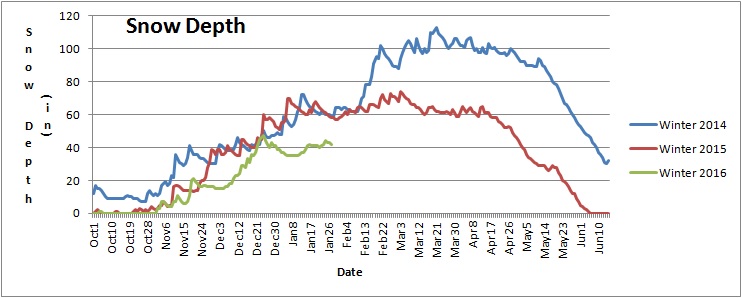
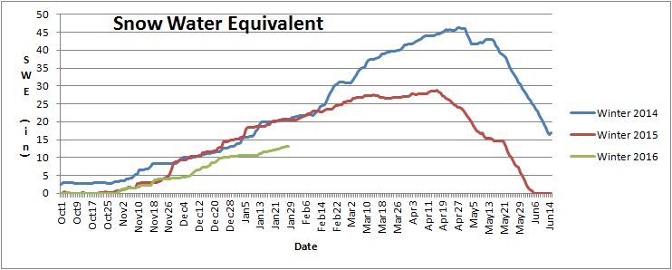
Jan 21, 2016 at 3:25 pm #3377115Badger Pass snotel is my benchmark for the whole Bob complex. Of all the snotels, it’s the most representative of what you need to worry about come late May, namely the amount and consistency of snow in upper-mid elevation north facing areas with dense timber. There’s plenty of spacial variability across the whole area, but by late May Badger will typically give a good picture of what you’ll find in comparable areas elsewhere.
Right now Badger is about halfway between the historic average and the historic minimum, but as the graph will tell you, only half of the years snow has fallen by now, and a big February or March could change things drastically.
Consider 2014, when my route took me over Badger on the way south. The SWE and snow depth chart for that year not only shows a lot of snow depth on May 28th, it shows a snow pack which was loosing depth faster than it was loosing water. That means the snow was compacting, rather than melting, which when you also have reasonably low daytimes tempts means snow which can be walked over without snowshoes and without postholing. I still brought snowshoes that year, as a lack of freezing nights and plenty of rain leading up to go day made it likely that lower elevation snow would be slushy. It was, and had I not had snowshoes the ~5 miles along Muskrat Creek to Beaver Lake would have been very slow. I kept my snowshoes on for the climb up and over Badger, but I did not need them.
Another thing to keep in mind is that in the two weeks prior to the Open the Badger area had lost 10 inches of SWE. That’s a lot, which I saw on the morning of day 2, when the Strawberry Creek ford right about the Middle Fork origin was up in the weeds and well over head high, compared to the year before when it wasn’t even knee deep.
Now look at the same data for 2013. Badger lost 10 inches of water in the same period of time leading up to the Open, but two things are worth noting which explain why that crossing of Strawberry was so mellow. First, the Badger area started with a bit less SWE, and meltoff started a bit earlier and was happened faster. This is significantly because the headwaters of Strawberry face dead south, and can be assumed to have melted considerably faster than the snotel area itself, which faces north. Second, the data shows a small plateau in snow depth which happened on memorial day weekend. This is because that Friday and Saturday were both fine sunny, mellow days, with clear and very cold nights. Sunday morning I woke up a ways past Wrong Creek on the North Fork of the Sun and my shoes were frozen solid, at a fairly low elevation. This pause in melt dropped creek levels considerably, even though the larger rivers did not. The Middle Fork dropped briefly below 10000 cfs at West Glacier, but my on the ground recollection is that most of the creeks dropped far more. The exception was of course south-facing creeks with relatively high elevation, multi-aspect headwaters, like Lodgepole and 25 Mile.
Charts are your friend.
Jan 21, 2016 at 3:51 pm #3377130great beta Dave- thanks!
Jan 28, 2016 at 11:44 am #3378691Stopped snowing up there yet? Anybody else find a route shorter than 90 miles ;-)
Jan 28, 2016 at 12:36 pm #3378702probably lost a little snow this week, several days above freezing- Great Falls was seeing a few days into the 50’s, fair bit of wind too that also tends to take snow
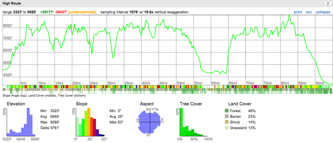
Jan 28, 2016 at 1:24 pm #3378710Just for heck of it I marked out a “high route” that comes in at 91 miles. 43k feet of elevation gain though. I’m sure my high route includes some knife-edge ridges that might not go as well as plenty of terrain that would require serious avalanche hazard mitigation.
Jan 28, 2016 at 4:59 pm #337875743k????! Something special needs to be done for anyone pulling off that route, even without taking into consideration the avalanche/terrain dangers. Finishing in one week on that route would be an amazing effort!
I too keep pretty close tabs on the Badger site. This year has been interesting, as a lot of low elevation snow has stuck around (at least here in Bozeman) which I think has led people to believe it’s a great snow year. I’m not liking the snowpack this year. Aside from being a dangerous snowpack (10 avy fatalities in 10 days this month in the US) , the mountains just aren’t getting a ton of snow so far.
As has been discussed here, the key months are March and April. Below is a great example between 2014 and 2015. Snow levels were nearly identical in mid-February. In 2014 the snow and moisture kept coming and we had lingering snowpack and high rivers well into summer. Somewhat related, we had a great August and September (i.e. no smoke). In 2015, you can see things dried up. The snow was pretty much gone by the time summer rolled around and rivers were flirting with record lows. There were campfire bans by July 4 and August was pretty miserable with fires/smoke. Badger is tracking well below both previous years right now. The good thing is, one big storm of 20-30 inches of snow can go a long ways, so let’s hope for that.
 Jan 28, 2016 at 8:03 pm #3378786
As Tanner and Dave wisely point out discussions of snow are rarely worth having until March has come and gone.
As for the high route here’s a profile. Google Earth tells me the route is 43k. Caltopo tells me its 35k. Either way it’s big, and the average elevation is nearly 7,000 feet so it is truly a high route.
Jan 29, 2016 at 10:58 am #3378892The first month of 2016 has been lame. Very modest precip and too damn warm. A good month for nordic skiing, but not a good harbinger of summer.
There is a killer ski route which would be awfully tempting in the right conditions. The AT rig I just finished is a hair over 5 pounds for skis/bindings..
Feb 15, 2016 at 2:38 pm #3382234For those who attended last year’s BMWO, or who are interested in seeing what it’s like to participate in a BMWO, I quickly put together the GoPro video clip segments from last year’s event. Note: I’m not a movie producer and have never edited a movie before. I only created this movie for fun and to document the journey, then decided recently it could be useful for someone planning to attend. Oh and Justin PM’d me and asked for the footage too since he’s in it (here you go Justin!). Have plenty of coffee on hand if you’re going to commit 42 minutes of your day to this. I know some the facts are off and the video quality is poor; I couldn’t quite figure out how to get YouTube to upload the video without compressing the res and lowering the bit-rate.
Feb 15, 2016 at 4:10 pm #3382246Nice! Brings back some great memories.
I can’t believe you guys wussed out on the SF ford
<—– wussed out too :)
Feb 15, 2016 at 5:06 pm #3382255Thanks, that video is great for a BMWO newbie like me!
Out of curiosity, do most of you guys carry bear fence (as shown in the video)? Guns? Bear bells? I admit I fast-forwarded at a couple points so forgive me if you talk about that in the movie and I missed it.
Feb 15, 2016 at 5:22 pm #3382260Thanks for sharing, Chase. I’m glad you didn’t include in the video the time you pistol-whipped Alex after he asked to stop and eat breakfast on Day 2.
Feb 15, 2016 at 5:27 pm #3382261I know, It’s really long and boring. Sorry, I’ll make the next one more interesting and cut out all the BS. No Jessica, we were the only one’s who carried all that crazy stuff. Alex and I are from NW Oregon and we don’t get to camp in bear territory much so we brought things that made our girlfriends feel better about us walking with grizzlies (okay fine, maybe we were a bit worried too). I pictured grizzlies roaming in every valley and meadow, but to my surprise we didn’t see a single grizz. We only saw one bear and it was an adolescent black bear who was very standoffish and wanted nothing to do with us. We were newbs, I’m much more comfortable with bears now that I’ve met one in the wild face-to-face (literally) and studied their behaviors in books. I definitely won’t be bringing my magnum or my bear fence this year, way too much weight and absolutely ridiculous (I did have the 5 best nights of backcountry sleep EVER with that fence around us). Debating leaving the bear spray too. I’ve been educating myself heavily on bears and their behaviors lately so I’m confident that If I select my camp site properly, cook on the trail, control/minimize odor, and pay attention to signs of uneasy behavior etc. I can avoid any problems with the bruins.
Feb 15, 2016 at 5:32 pm #3382262I’m confident that If i select my camp properly, cook on the trail, odor control, and pay attention to signs of uneasy behavior etc. I can avoid any problems with the bruins.
Cool! That was my assumption/approach too, until I watched your video, and then I wondered if I was missing something… good to know you felt overprepared in terms of “bear-protection.” :)
As for the video, I watched almost all of it, and it was great! Thanks again.
Feb 15, 2016 at 5:40 pm #3382263hey but that .44 was titanium! :)
I’ve been involved (after the fact) with several grizzly encounters in my former career and I will continue to carry bear spray in grizzly country (anywhere else it stays home)- granted chances are slim in needing it, but if you did………..
Feb 15, 2016 at 6:54 pm #3382266Jessica,
This is the best video I’ve seen that provides information on what to bring when hiking in bear country, and what to do in the event of an encounter: https://www.youtube.com/watch?v=PExlT-5VU-Y
Oh, and I made that stuff up about Chase pistol-whipping his hiking partner. Sorry Chase.
-
AuthorPosts
- You must be logged in to reply to this topic.
Forum Posting
A Membership is required to post in the forums. Login or become a member to post in the member forums!
Trail Days Online! 2025 is this week:

Thursday, February 27 through Saturday, March 1 - Registration is Free.
Our Community Posts are Moderated
Backpacking Light community posts are moderated and here to foster helpful and positive discussions about lightweight backpacking. Please be mindful of our values and boundaries and review our Community Guidelines prior to posting.
Get the Newsletter
Gear Research & Discovery Tools
- Browse our curated Gear Shop
- See the latest Gear Deals and Sales
- Our Recommendations
- Search for Gear on Sale with the Gear Finder
- Used Gear Swap
- Member Gear Reviews and BPL Gear Review Articles
- Browse by Gear Type or Brand.
