Topic

White Mt., CA

  • This topic is empty.
Viewing 9 posts - 1 through 9 (of 9 total)
Don A. BPL Member
PostedJul 29, 2015 at 3:15 pm

Over the years of hiking in the Sierra I've paid little attention to the nearby White Mountain range. Last weekend I was invited to join a couple of friends to go into the Whites to climb White Mountain and also to visit the Ancient Bristlecone Pine forest in the area. It sounded like a great adventure to me. 4600 year old trees and a 14'er to bag.
Twice a year the road to the White Mt. trailhead is opened beyond the normally locked gate to the Bancroft Research Station, shaving 2 miles off the summit hike.
We headed up Sat. morning from the LA area and arrived at the Grandview Campground. After setting up we drove another 5 miles to the Schulman Grove to check out the Bristlecone Pines. It hard to grasp the age of these trees and their ability to survive in the harsh environment if Whites.
Sunday morning we headed up to the Bancroft Research Station where we began our hike. The hike starts at 12,470ft. and White Mt. is 14,246ft. The distance is relatively short at about 10 miles round trip. The weather was great. Sunny and cool with mild wind. The trail is actually a 4 wheel drive track all the way to the summit though I can't image driving up there in any vehicle. There is a research hut at the summit that is reminiscent of the summit hut at Mt. Whitney.
On the summit the view is spectacular. The entire length of the Sierra is seen to the west and areas of Death Valley are visible to the southeast. Interesting to stand on the second highest peak in the lower 48 and see the highest peak, Mt. Whitney and Mt. Williamson the second highest peak.
I would highly recommend taking time to visit the Whites. It's somewhat of a hidden treasure.
The destination.
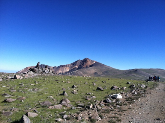
White Mt.
View from the summit. Mt. Whitney to Mt. Abbot
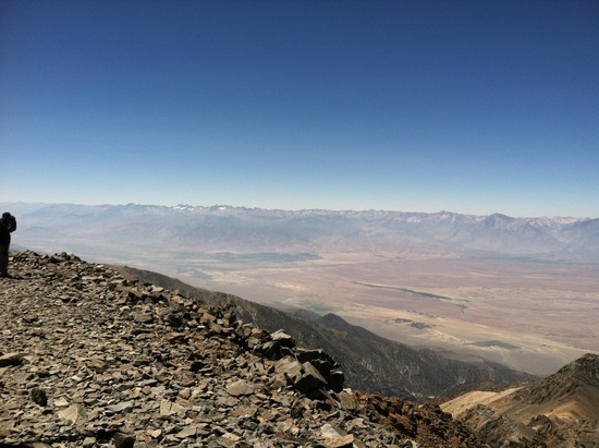
View from summit.  Mt. Whitney to Mt. Abbot
The summit hut.
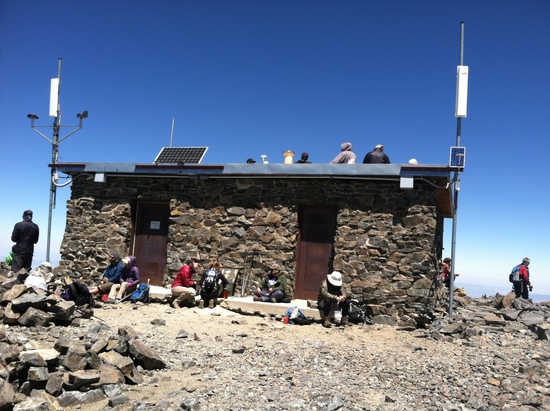
White Mt. Summit Hut

Angus A. BPL Member
PostedJul 29, 2015 at 3:37 pm

Looked up some photos of the area…it's amazing. Would love to check it out one day.

We need to plan a backpacking trip again.

Ken Thompson BPL Member
PostedJul 30, 2015 at 6:44 am

Bad weather aborted our trip there to the summit. The Bristlecone Forest was amazing. Six week growing season and wood so hard it erodes instead of rots up there. Need to get back. A little gem of an area certainly.

PostedJul 30, 2015 at 10:05 am

wow the view is incredible from the summit. i have been to the grove for sunrise on the sierra, but not higher. seems like it's time for a summit hike. was just down in owens valley and looking up at the whites, but it's a whole different view from the top. nice!

PostedJul 30, 2015 at 5:32 pm

Nice pics Don.

My daughter and I attempted to hike to the summit last Sept., but were stymied by the remnants of a snow storm from the prior week and couldn't make it up the last 1,000 ft. without risking coming back in the dark. She needed to bag a 13,000'+ peak for Girl Scouts, and we made it to 13,300. I'd say, after about 12,000' we had to stray off the road about 50% of the time to avoid post-holing through softening snow. We saw some bike riders attempting to slog up through the slush and it looked downright miserable. To their credit, they were doing the right thing by not going off the road into the "tundra." Hopefully the road/trail will be snow-free by end-July.

If you camp up there (e.g. Grandview), bring a telescope if you can. Even with a cheapy from Walmart you can see the rings around Saturn. We had an amateur astronomer who brought his 12" Dobsonian telescope and were able to see some pretty cool stuff (nebulae, star clusters).

If you hike the bristlecone pine forest, and want to see the Methusula tree, it is no longer signed due to past vandalism (unbelievably, people cut branches off as souvenirs). So search the web for pictures and you may recognize it; otherwise, you probably "saw it" anyway if you hike the whole trail.

Pedestrian BPL Member
PostedJul 30, 2015 at 10:20 pm

The most important thing to note is that Grandview is a DRY campground! Bring all the water you'll need for as many days as you plan to spend up there.

As others have noted, the drive past Schulman grove is a dirt road that can get rutted and has rocks strewn about. While I've seen people make it up to the White Mtn Trail head in a Honda Civic, it's gotta be painful and the car may not survive the abuse even if the passengers do.

My friend drove us in his Ford F150 – going back down was worse than going up.

Ken Thompson BPL Member
PostedJul 31, 2015 at 6:12 am

"While I've seen people make it up to the White Mtn Trail head in a Honda Civic"

Been there, done that. No big deal. Took the 4WD road on the west slope that drops you off in Bishop. A few stream fords and all was good. Still driving that Civic.

Don A. BPL Member
PostedJul 31, 2015 at 1:51 pm

I guess I still fantasize about Mrs. Robinson after all these years. Thanks for the correction Mike.
Regarding the road to the trailhead (the locked gate and the Barcroft Research Station), it was in good shape. There were a few Civic type vehicles up there. I don't think I would attempt the 4WD route to Bishop like Ken but I'm probably not as adventurous as him. The dirt road to the trailhead starts at the Schulman Grove parking area that's about 5 miles from the campground. Oddly there is a short section of paved road on the way up between Schulman Grove and Barcroft. If anyone has an explanation for that mystery fill us in.
I suspect the dirt road could be rough and possibly impassible after storms and/or a hard winter. Then again the station is manned about 6 months out of the year depending on snow conditions so the road is probably maintained regularly.

Viewing 9 posts - 1 through 9 (of 9 total)
Loading...