


Subtract 3.4*F per 1000ft of elevation gain from your forecast area and that "should" get you close.
Of course the weather tends to be more volatile at elevation so keep that in mind.
Topic
Become a member to post in the forums.
Subtract 3.4*F per 1000ft of elevation gain from your forecast area and that "should" get you close.
Of course the weather tends to be more volatile at elevation so keep that in mind.

sometimes there are inversions, temperature actually goes up with altitude
scrolling around on that weather.gov link should find actual forecast for that day
I just scrolled over to Packwood – tonights low 56 F at 1585 feet, 7057 feet is 53 F – hardly any difference with altitude – 0.5 F per 1000 feet
If you look at high temperature it's 4.2 F per 1000 feet which is pretty close to your rule
"Both of your links look like they give temp forecasts for Packwood (elev. 1290') so I'm guessing that's not going to tell me much about what's going on at 7K, but should warn of possible storms. I'll be keeping an eye on it."
No. That's one of the annoying design features of NWS's site. The 1290' is for the nearest weather station to the point you've clicked on. Why it leads off with current conditions somewhere other than where you asked for the forecast, only a low-paid government contractor employee could explain.(*) Scroll down to the next block of information that's labeled something like
Extended Forecast for
9 Miles SSW White Pass WA
and you're looking at the higher elevation point you asked for. Just a little further down and on the right side, just below the clickable/zoomable map, it tells you exactly what elevation the point forecast applies to. On my link it's 6142'; on Jerry's it was a little higher.
(*)Disclaimer: I work for a government contractor…
So I just want to post a quick follow up here. Goat rocks was spectacular, awesome, amazing, etc!
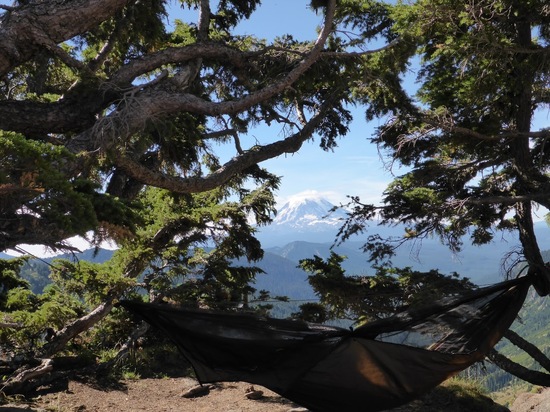
Thanks so much to Todd and Jerry for all the advice. I had a great trip. The weather cooperated perfectly. Cool nights, warm days and no rain. There were lots of other people on the trails but I never felt too crowded. I mostly hiked my plan. Camped first two nights off the Lily Basin Trail about halfway between the Flats and the Lake. Got to the top of Old Snowy and out on the Knife Edge on PCT. The third night I camped at Goat Lake instead of Jordan Basin. I got to the Lake at 9am on Sunday morning and the crowds were packing up. I was able to get a sweet hammock site near where Goat Creek goes over the edge. I set up camp and day hiked up to Hawkeye Point and then out to Johnson Creek. I’m going to have a hard time topping this campsite:
The other 250 pictures I took are HERE in case you’re interested.
thanks again BPLers for steering me to a fantastic place.
good that worked out
I may head up there in the next couple months
forest fires may affect my decision – either areas closed, or too much smoke
Become a member to post in the forums.
 New Gear with Aluula FabricsLighter, stronger, more abrasion-resistant, and highly water-resistant - explore ultralight backpacking gear made with ALUULA Graflyte fabrics. Engineered for exceptional strength, durability, and lightweight performance, ALUULA Graflyte helps reduce pack weight without sacrificing reliability, making it ideal for demanding backcountry adventures.
 © Beartooth Media Group Inc.
 Loading...