Topic
Missing hiker found dead in the Whites
Forum Posting
A Membership is required to post in the forums. Login or become a member to post in the member forums!
Home › Forums › General Forums › General Lightweight Backpacking Discussion › Missing hiker found dead in the Whites
- This topic is empty.
-
AuthorPosts
-
Feb 16, 2015 at 5:37 pm #1325813
-30F and winds over 100mph. 32 yrs old – Same age as my wife. What a shame. Video and more information at link.
http://www.wmur.com/news/rescuers-search-for-missing-hiker-near-mt-adams/31294362
Ryan
Feb 16, 2015 at 6:12 pm #2174838That is very sad… such a young woman! You have to wonder what reasoning was used to reach the decision to proceed in such brutal conditions.
A group of us used to hike up there quite a bit in the winter, and the closest we ever came to having a fatality on a hike was in that very same area, same time of the year. One of our members was trailing behind, hypothermic and incoherent, and was very nearly lost in a whiteout while I was having a serious discussion with my co-leader about navigation. No GPS then, and we had exactly one known landmark to work with and exactly one chance to get the bearing right. We were very relieved not to end up as statistics.
Feb 16, 2015 at 6:15 pm #2174839When somebody gets into trouble like that (slow and hypothermic) one of the next symptoms is loss of good judgment.
–B.G.–
Feb 16, 2015 at 6:40 pm #2174845:( definitely wouldnt want to be there in that weather. it is a few miles back to the road from there too. Madison hut isn't open during the winter either.
you definitely don't day hike from appalachia to mt washington (and back?) solo in the winter in those conditions… not sure what was going on in thinking or communication of the plan.
Feb 16, 2015 at 7:00 pm #2174850The Whites have to be the most notorious mountains here in the US. Very sad.
Feb 16, 2015 at 7:28 pm #2174862This sign is posted on many many trails.. I read it every time. It should make you think real hard.
 Feb 16, 2015 at 7:46 pm #2174870
"The beacon signal, initially picked up by the Air Force Rescue Center in Panama City, Fla., was pinged to a coordinate between Mount Madison and Mount Adams."
"The beacon signal showed a coordinate between Mt. Madison and Mt. Adams. Attempts to contact Matrosova via her cell and satellite phones were unsuccessful, and a rescue mission was launched."
"Unfortunately, a lot of the coordinates that we received over the night are all over the place within a mile circumference,"
So, a McMurdo, ACR, or similar PLB (versus a SPOT or inReach) was used.
I found only the above reference to the sat phone, so that is suspect.This reinforces my belief that even though I carry a PLB, I've got to be able to take care of myself for a couple of days, regardless of the situation. There are lots of reasons why the calvary can be delayed.
And it reminds me that even when I'm at a trailhead, or half way up the trail, turning back is always an option.
Hats off the S&R.
And condolences to the family.This was an avoidable tragedy.
Feb 16, 2015 at 8:39 pm #2174880Sad news. One possible reason the coordinates were all over the place would be that she had no choice but to keep moving in an attempt to stay warm. This would happen if her insulation was inadequate, possibly because her shell layer wasn't blocking enough wind. (Quite likely at 100+ mph!)
Bob, it was interesting to hear about your experience there this time of year. Glad everyone made it out!
Feb 17, 2015 at 5:00 am #2174918The key is to get down to treeline and out of the wind, but the approaches to the ravines can be extremely treacherous.
But as BG mentioned, judgement becomes impaired.
A photo from that area in comparatively benign conditions…
Feb 17, 2015 at 8:20 am #2174963Here is a rescue case study about the challenge of PLBs and the "error" rate
http://blog.oplopanax.ca/2011/08/personal-locator-beacons-from-the-rescuer’s-perspective/
The conditions of this search were far less than ideal. The DeBeck Creek valley in that area is deep, heavily forested and has significant terrain to the north and south, blocking clear views of the sky and the satellites. Additionally, the heavy rain and cloud cover could interfere with both the GPS satellite signal reception, and the 406MHz signal transmission. I suspect, based on our experience and the data (see map below), that the PLB didn’t manage to calculate a GPS fix until late morning on Tuesday, after being in operation for almost 24 hours.
I made the point in a previous thread (before it degenirted to its usual BPL fun) that no matter the conditions you have to be able to survive the night and possibly longer … You cant always run out if the conditions are heinous or if yr injured
What is less obvious if that you need to be able to survive at roughly the same spot you triggered the PLB … SAR reports up here are filled with folks running around while SAR is looking for em, making everyones job harder and more dangerous … Once you trigger a rescue stay in thr same general place as best you can
I have no idea how those mountains in new england are right now, but if someone said theyre going solo in -30F weather and 100 MPH winds i would hope they are exceptionally experienced folks who are training for an antarctic expedition
Feb 17, 2015 at 10:36 am #2175023Good points Eric.
Ryan
Feb 17, 2015 at 11:06 am #2175037My friends and I used to do a yearly February backpacking trip to the Mt. Adams area. Most of the time we were pretty lucky with the weather, but one year was not so great (windy, cold). We brought all the stuff (snowshoes, full crampons, insulation tops/bottoms, mountaineering stoves; I even wore plastic mountaineering boots).
Knowing the area well, I immediately wondered what the poor woman was thinking — even on a sunny summer day (which you can't count on in the White Mtns), that would be a pretty ambitious hike. And yes, it would have to be a "return" trip, because the road up Mt. Washington is closed in winter (some people snowshoe up and ski down).
If she had made it to the summit of Mt. Washington, the weather observatory would be manned, and she could have gotten help. But even sadder is that there's a small hut near Mt. Adams that is open in the winter (sometimes manned; sometimes not), but it has a woodstove, and she would have been out of the wind.
It sounds like she didn't know much about the area, and it very sadly cost her life.
Edited to add more detail (see post from Jake D, below) — No, I was not referring to the Lake of the Clouds Hut; the small hut I'm talking about is not part of the AMC system, and IS open in winter. But if I were in dire straights as she must have been, and the AMC hut was visible, I would use a rock to break in, save my life, and deal with the consequences of my B&E later!
Feb 17, 2015 at 11:18 am #2175045She was using an ACR ResQLink 375, coincidently the same one I use. Reportedly it transmitted multiple incorrect locations, the reasons for that have yet to be analyzed. I've asked NH F & G for updates when they come available.
Feb 17, 2015 at 11:43 am #2175051Bob Moulder, that is a good photo with all of the red jackets. That's about what it looked like on the summit of Mt. Washington at the first time I went up there. Yes, and that was good weather.
–B.G.–
Feb 17, 2015 at 11:55 am #2175056"Reportedly it transmitted multiple incorrect locations, the reasons for that have yet to be analyzed."
A device like this can't think up random location data to transmit. It transmits its location as best that it can guess. The issue is that its internal GPS receiver functions can get mightily screwed up in certain conditions, so it will transmit those screwed up positions and vary a bit.
Normally, a GPS receiver will have only small position errors. If you hang a ball of ice over the antenna, then you will get all kinds of error. It is nice that it was able to transmit positions that varied over a mile, because that will get SAR people into the ballpark. There are just so many things that the user can do that will cause problems for GPS. Transmitting from underneath an ice-laden tree tends to get bad results.
On the first time that I climbed Mt. Washington, I wanted to prevent this very problem, so I put the GPS antenna between two layers of warm hat on my head. That way, it was always pointed upward, and it was unlikely to be blocked by anything, and it was unlikely to have a big ball of ice on it.
–B.G.–
Feb 17, 2015 at 12:12 pm #2175061It takes hours to mobilize a rescue even somewhere only a few miles from a road, it takes even longer in those insane conditions and reportedly she wasn't prepared to stay put above treeline like that. I doubt it would have mattered if her beacon was spot on or malfunctioning, she hit it at 3:30 PM and SAR was unable to reach her until the next day.
The mount washington observatory higher summits forecast urged people to stay out of the mountains and below treeline since rescuers would not be able to help until the weather cleared, which is exactly what happened.
Feb 17, 2015 at 2:01 pm #2175091I haven't seen anywhere that indicates if she was out for an overnight backpacking type trip or an ambitious dayhike. Does anyone know if she actually had overnight gear with her??
I just can't imagine heading out in that!
Feb 17, 2015 at 2:15 pm #2175094" But even sadder is that there's a small hut near Mt. Adams that is open in the winter (sometimes manned; sometimes not), but it has a woodstove, and she would have been out of the wind."
Do you mean Lake of the Clouds hut? that is not open in the winter. There is a small room that is sometimes open called the Dungeon but it could be buried in snow or locked. A few years ago they had problems with people using it as a camping destination instead of the intended emergency shelter only.
Carter notch, zealand and Lonesome lake are the only ones open during the winter.. and the Highland center. http://www.outdoors.org/lodging/availability/index.cfm/fuseaction/availability.main
Feb 17, 2015 at 2:34 pm #2175099Feb 17, 2015 at 3:16 pm #2175118https://www.youtube.com/watch?v=DP4u6VyrgCk#t=43
Video by SAR during the search.. that is in "improved" conditions on day 2 i believe. Props to them for sure.
Feb 17, 2015 at 3:20 pm #2175119I have to wonder if this is an instance where carrying a PLB put the young woman at greater risk. While it is impossible to know what she was thinking when she headed out there is a chance she assumed that a push of a button would make up for other gear or safety precautions and encouraged risk taking. Perhaps not, but safety devices don't always make us safer.
Feb 17, 2015 at 6:06 pm #2175188Putting GPS theory and operation aside (and it would serve users of PLB's well to understand it as you did), what gets looked at first in a case like this, and where my interest lies, is any defect in the unit itself.
Having used EPIRB's and now PLB's professionally and personally for going on twenty years, been involved as a nearby able vessel in SAR response under seriously bad conditions, and, yes, been the subject of an intensive nighttime search in the Gulf of Maine due to a manufacturing defect in an EPIRB I have more than a passing interest how this particular unit performed.
But, more than that, is the knowledge that when that come get me button is pushed, people are going to come, and I don't want somebody putting their life at risk because my PLB wasn't 100%. Having someone I knew personally die up there while trying to save two people from their bad decision only makes that responsibility more real for me.
Feb 18, 2015 at 7:51 am #2175331Thanks to all for your excellent discussion. I only backpack in three seasons, and I'm not well schooled in the various emergency devices, but I do carry a SPOT. It never occurred to me that a device's signal could fail even from a mountaintop.
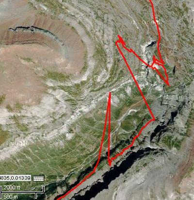
Feb 18, 2015 at 8:32 am #2175344GPS is very accurate most of the time, but many people do not realise how inaccurate it can be in the 'wrong' conditions. When you are surrounded by high, steep slopes GPS suffers from 'multi-path reflection' that can put your position out by a mile or more. Even if you are stationary, your apparent position can move rapidly as the satellites orbit. Here is a track recorded with a regular GPS that apparently has me skipping across to the other side of the valley and back.
 Feb 18, 2015 at 11:18 am #2175404
GPS reception can be tricky. Stuart mentioned multipath reflection, also called multipath interference. That tends to happen worst when there are large surfaces of smooth vertical rock. They act like mirrors, so they tend to make your apparent position jump around erratically. The same thing happens deep in the metal and glass canyons of Manhattan.
RF interference can happen anyplace, although the GPS frequency is about 1.57GHz, and there isn't a lot of stuff that operates near there except for some point-to-point microwave radio. Harmonic frequencies from cell phone towers might do it. It might be possible that a high voltage power line might do it, but I have never personally seen it happen. If you had any sort of radio transmitter (FM, FRS, GMRS, etc) and you transmit right next to a GPS receiver, that will do it. When this happens, all satellite reception is lost temporarily.
A GPS blunder is amazing to observe. They don't happen so much anymore ever since the satellite constellation has gotten so robust.
–B.G.–
-
AuthorPosts


- You must be logged in to reply to this topic.
Forum Posting
A Membership is required to post in the forums. Login or become a member to post in the member forums!
Our Community Posts are Moderated
Backpacking Light community posts are moderated and here to foster helpful and positive discussions about lightweight backpacking. Please be mindful of our values and boundaries and review our Community Guidelines prior to posting.
Get the Newsletter
Gear Research & Discovery Tools
- Browse our curated Gear Shop
- See the latest Gear Deals and Sales
- Our Recommendations
- Search for Gear on Sale with the Gear Finder
- Used Gear Swap
- Member Gear Reviews and BPL Gear Review Articles
- Browse by Gear Type or Brand.
