
Over the last two years, I have had many grand backpacking plans get compressed, radically changed, or nixed altogether – as I know many of us have. A free summer for slow section hiking with friends turned into a two-week solo sprint as family, school, work, and COVID slowly chipped away at my backpacking tithe. When my graduate program gave us a full ten days off for Thanksgiving during an unseasonably warm and dry Colorado fall, I knew I had to take the opportunity to get out there, move my body, see the land and reset my mind.
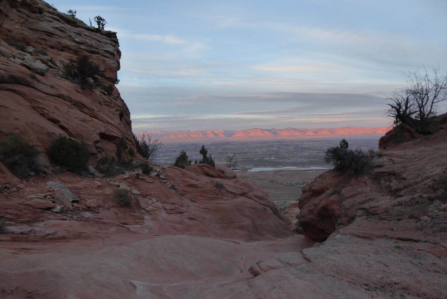
I know it will not get easier to find a free week as the rest of life continues to sink its hooks into me. I looked for a trip accessible by public transit, not too cold for my current skill level, and not devoid of water sources, and settled on jumping off from Grand Junction, Colorado. I would start in Colorado National Monument, hike down to the Colorado River, then go west and south through the canyons and ridges of the Black Ridge Canyons Wilderness, and finally end walking down Monument Canyon. My prior experience in this area consisted entirely of oohing and aahing while driving through. I looked forward to exploring the truly breathtaking canyon country in the offseason.
Getting there
My trip started from my house in Fort Collins. I journeyed from there to Denver Union Station, where I caught the Bustang West across the state. One of my favorite differences in hiking here in the Mountain West versus Northern Virginia, where I grew up, is that the entire trip to the trailhead is breathtaking the whole way. The Bustang wound its way up and over the Front Range and Vail Pass, then descended deep into Glenwood Canyon. Here engineers had diverted the mighty Colorado through the sheer cliffs to avoid the mudslide dams that clogged the river with debris loosened by the recent Grizzly Creek Fire. We kept moving west, watching a herd of bighorn sheep as we passed through De Beque canyon before finally arriving in the Grand Valley.
After catching a local bus from Grand Junction to Fruita, I set out on foot from the valley floor through giant slabs of rock, sloping and slipping away from the fault that drove them up thousands of feet some sixty million years before. I marveled at the sheer size of the landscape. Just as you have a different feel for a mountain looking at it versus climbing it, I felt the true enormity of the cliffs and canyons for the first time. I had to start at the National Monument visitor center to get a permit to camp within the park boundaries. I planned to hike out of the park and only really see the monument on my last day, and the trip through geologic time excited me for the next few days of exploration.
I was hoping that the rangers at the visitor center would point me to some unmapped reliable source of water that I could use after filling up at the Colorado. No such luck. After amending my last day’s route on the ranger’s advice and acquiring my backcountry permit, I filled up my water and hit the trail.
Canyon country
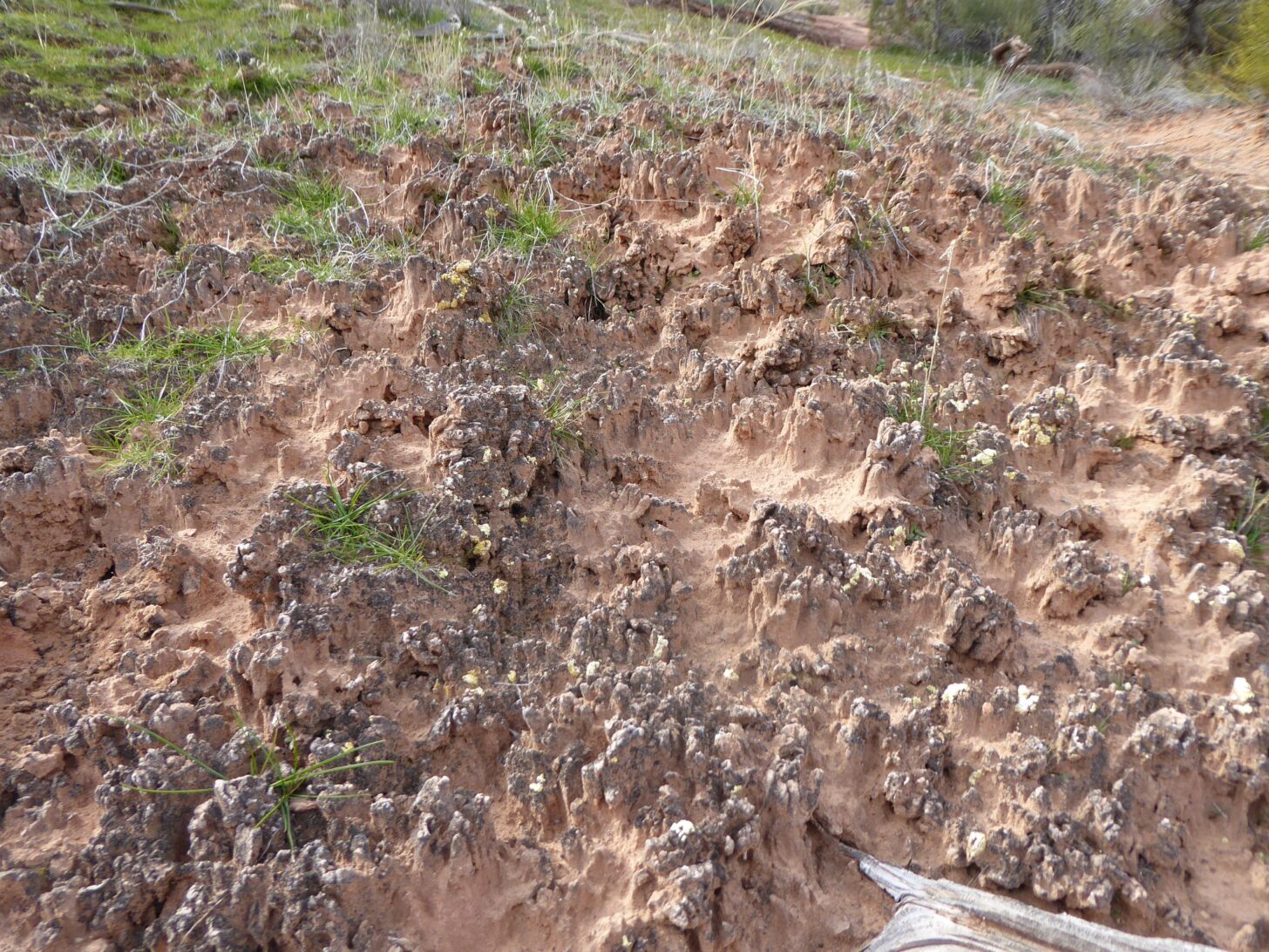
I walked east from the visitor center, away from the canyon edge, then turned north onto a historic Civilian Conservation Corps (CCC) trail. The trail often went invisible, and I found ground feedback just as helpful as vision in navigation. When I strayed from the trail even a few inches, the hard-packed sand became noticeably softer. On the occasions when this warning was not enough, one step further would send me sinking through the sand-covered biological crust. The travel to the trailhead had eaten most of the daylight, but I made good time and only had a few easy miles to go until my planned first-night campsite. I came to the edge of a canyon that seemed enormous and walked along the ridge, marveling at the depth and steepness. This canyon was rapidly overshadowed by the next, and the next, until I stopped keeping track and just marveled at each new canyon individually.
As I walked, I thought about the young men who, a century before, built the trail I was using. During the depths of the Great Depression, the federal government employed young men to develop its natural resources. They built roads, trails, buildings, fire towers, dams, and more, relying on literal manpower swinging pickaxes and shovels. I reflected on how different their world was. The CCC was one of the most popular programs of the New Deal and employed only unmarried men. Crews were racially segregated, and run by veterans of WWI. Each worker was paid $30 a month, which when adjusted for inflation, would be around $600 in today’s money. Each man was required to send $25 of that home to his family.
I have a personal relationship with so many CCC projects. A trip to Glacier National Park up the Going to the Sun Road as a kid helped spark a love of the Mountain West. Trail Ridge Road through Rocky Mountain National Park is my extended backyard and cross country ski trail. Back in Virginia, many of the lakes and parks I explored as a kid had trails built by the CCC. My friends held my bachelor party in a cabin built by the CCC in Shenandoah National Park, just off of Skyline Drive – which the CCC built too.
I turned into the side canyon that would host me for the night and followed the bone-dry streambed up to a place level enough to hold me. I pack a bivy sack when traveling alone, and love how simple it makes campsite selection – if I can fit my body laying down, it’ll work! I often try to find a spot that is sheltered from the wind or angled in a way that I’ll be able to watch the sunrise warm and snug in my bag. This flexibility lets me hike as long as I want without worrying about having enough light for campsite selection and set up. After dinner, I wiggled down into my quilt and waited for the best perk of bivy camping: the stars.
Most of my backpacking experience has been in the long-light days of summer, and I like to hike until or past sunset, so it was a strange experience to be done with the day before 6 pm. In preparation for my hike, I had read and watched Ryan Jordan’s field notes on winter backpacking. Most of the tips and tricks I learned there were much more useful on a later cross country ski trip with, you know, snow. But I did learn to bring my headphones and download an audiobook to help with the hours of darkness before sleep. My sister had recently picked The Anthropocene Reviewed for our family book club, and I found it a perfect companion for my activity and thoughts for the day.
Day two of my trip started with a hike down to the Colorado to fill up my water for the rest of the trip. It was a Saturday, and as I left the park, I passed many people out for a morning run or exercising their dogs. The trails intertwined, some with good signage and many without, but my route was easy – follow the water as it descended to the river. Or, at least, follow where the water would be, as every streambed I walked in was as dry as dust. I reminded myself that while I might hope to find a water source back up on the Uncompahgre Plateau, my map research, the ranger, and everything around me told me that I should act like I wouldn’t. I needed to camel up.
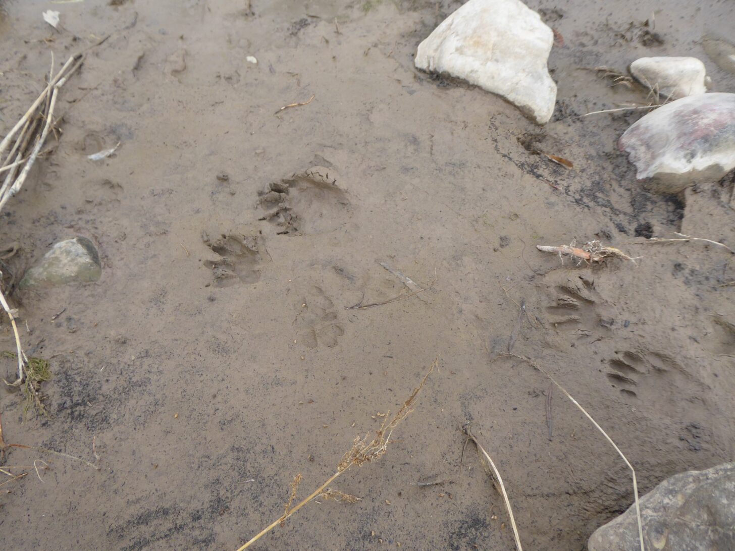
The arid landscape gave way to the river startlingly fast. Desert sand and rock turned to mud so deep that I had to balance on rocks to get close enough to fill my water. It was still very cold, with ice crystals hovering over the eddies, and it took some courage to let any of my hand touch the water. On most trips, filling three-fourths of every bottle would have saved my fingers from the cold water. But I knew I did not want to head back into the desert with anything less than all I could carry, so I grit my teeth and topped my bottles off. I took a break in a nearby duck stand facing the perfect direction to block the wind but keep the warmth of the sun, and rubbed some feeling back into my fingers while I snacked and drank water. The world in front of me was in stark contrast from the one behind me, with bright green grass, huge cottonwoods, and raccoon and waterfowl tracks crisscrossing the mud. After basking and sipping as much water as I felt reasonable without risking hyponatremia, I hopped the rocks back to the river, filled my last bottles, and headed back up the next canyon.
Detours: voluntary and involuntary
I had the option of a shorter route to Rattlesnake Canyon or a detour that my cousin, formerly of Grand Junction, had highly recommended. While my pack was now quite heavy with water – even my cook pot was full – I reasoned that the theme of this trip so far had been taking advantage of the opportunities as they came. So I turned south up Flume canyon. The landscape immediately rewarded me with geography that reminded me more of wadis in the desert of Jordan than of any mental pictures I had of Colorado.
Member Exclusive
A Premium or Unlimited Membership* is required to view the rest of this article.
* A Basic Membership is required to view Member Q&A events

Discussion
Become a member to post in the forums.
Companion forum thread to: Canyons and Contemplation
Exploration and reflection on a backpacking trip in the Black Ridge Canyons Wilderness
Loved this, love the use of public transport to get to the trail. DM me if you want some info on another canyon route in this area
Thanks! I will message you next time I’m looking at that area. My wife needed our car, glad I could make it work anyways
Become a member to post in the forums.