Topic

Winter Superstition Mountain Backpacking – Need Help!

Viewing 6 posts - 1 through 6 (of 6 total)
Al K BPL Member
PostedDec 15, 2025 at 12:35 pm

I was supposed to do Cottonwood/Marble Canyon in Death Valley during Christmas week but just found out the road to it got washed out and need to pivot to something else…like the Superstition Mountains. I have three days on the trail Tuesday 12/22 to December 12/25. We want to cover some ground but somewhat chill (8-13 miles a day depending on difficulty).

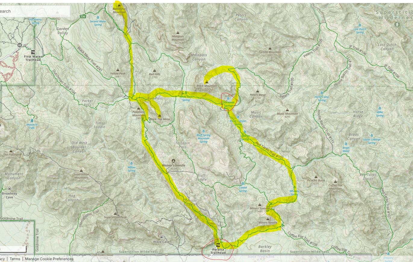
Since this is a last minute switch, I do not have much time for research so turning to others for help. In the picture below I strung together what looks like a 20 mile loop plus another 5-10 miles of side trips up Battleship Mountain, Black Top Mesa, and Black Mountain. Am I missing any highlights or sections of trail I should do in addition to or instead of what I highlighted? We would start/end at Peralta (we have just one car) unless anyone advises otherwise.

Also, is water just at the circled Charlebois spring? Anywhere else?

Is temps pretty mild? I am seeing 7 day forecast for 50-77F degree range. Is that typical?

Anything else I should consider like where to camp, etc.

Thank you for any advice!

PostedDec 15, 2025 at 1:17 pm

Great route, if you get a chance for a couple of side trips, both Music Canyon and Trap Canyon are really beautiful.

Al K BPL Member
PostedDec 15, 2025 at 1:47 pm

I see that both Music Canyon and Trap Canyon are south of Charlebois Spring. Is the idea to just start off trailing up the canyon a bit to explore? Or is there a specific thing to see “X” miles up the canyons?

PostedDec 15, 2025 at 1:58 pm

The prettiest parts of both canyons are where the walls constrict and the canyons get narrow, lots of pretty greenery in both of them, they’re just very quiet and serene places, and feel like an oasis in the otherwise barren landscape.

The neatest part of Music canyon is about 1/2 mile up from the trail. Trap Canyon is more rugged, and it’s about a mile from the trail to get up into the heart of it.

Steve Thompson BPL Member
PostedDec 16, 2025 at 8:04 pm

Very nice route, pretty close to one I day hike. Since it will be one month since any rain Charlebois could be iffy.  LaBarge Spring is always the better bet. Suggest reaching out on hikearizona.com you may find someone with a current report.

Arthur BPL Member
PostedDec 16, 2025 at 10:17 pm

I have had the same issue in the Cottonwood Marble Canyon road being washed out.  We hiked it from the West side.  Longer dirt road to the “trailhead” at Quackenbush Mine.  If the road is not wet, 4wd is not necessary. If its wet, it can be ugly with clay.  Trail is often called the Upper Marble Canyon Trail to the big loop.  Some minor bushwacking due to lack of use, but no big deal and easy navigation. I’ve done the Supes area you are talking about many times and the other posters have covered it well. Understand in the last 4-5 years 120,000+ acres of the 160,000 acres of the Superstitions have burned. Little news coverage because Ca was burning and the Supes have no human structures to burn so it was left to burn.   Many annual and hearty small woody plants are coming back, I will not live long enough to see the grand saguaros and other cactus recover. It’s still beautiful and I still recommend it.

Viewing 6 posts - 1 through 6 (of 6 total)
Loading...